DirefulSine5563, would you know where I can download a free ingame VR map that shows ICAO? Unfortunately fspm-panel-vfrmap no longer shows ICAO, it was a great map until it got broken and never fixed.
Moved as this was Off-Topic in G3000 Support thread.
A bit overkill but the excellent (free) Little Navmap provides plenty of info via the in-game panel which you can open in VR. Just configure what you want to see before you start as the only thing that can be changed in VR is the range, and it’s not particularly big. If you get the associated maps with it, you can choose the background, Google, StreetMaps etc. I think there may be one for VFR charts but not for everywhere - no UK for instance.
Thanks a lot Terrylawdinn I’ll try it out and let you know!
not free but excellent, the all in one gamepanel. maps, little navmap display, and much more.
Trying to find how to enable it in VR…overkill is for sure.
Little Navmap is not working in VR and using the fix cripples all the functions…so I’m back looking for a free moving map that shows ICAO.
Littlenavmap works with the All in one panel in VR!
Instructions are in the LNM help files - but yes they are somewhat detailed!
You need to download the fs-base-ingamepanels-lnm, link in the LNM help file, and make sure it gets into your Community Folder. This puts the link into the on-screen toolbar (maybe blank/no icon but it’s there). Then in Little Navmap click on Run Webserver in the Tools drop-down menu. In VR just select LNM from the screen toolbar and move it to somewhere convenient - you might have to click on the minimise button twice.
I use it all the time but now having a go at All-In-One as it looks to be more comprehensive and hopefully will take up less visual room (and maybe resources too!)
Navigraph also has an excellent VFR in-game panel, suitable for use with VR
Hi thank you all for all the feedback! I read the help manual earlier and installed bkiel-ingamepanels-lnm not fs-base-ingamepanels-lnm, are they the same.
Working well now…lots to read lots of settings.
I’m trying to figure out in settings how to get 'panel can read data correctly…NO to switch to YES.
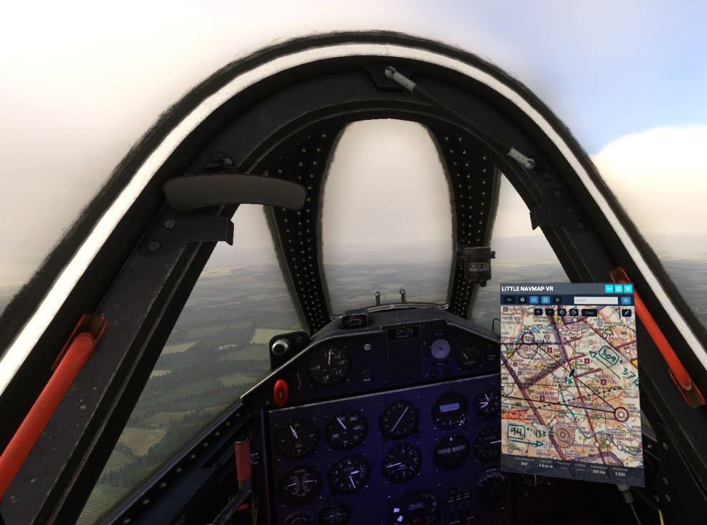
This is the Little Navmap VR Panel I’m using…works well.
https://flightsim.to/file/43086/little-navmap-vr-panel
How did you like All-In-One? If you recommend it please send link.
I’ll admit to having a few problems getting it to work and almost gave up but emails back and forth to a very helpful developer assisted me in locating the problem - which turned out to be my anti-virus programme, the otherwise excellent Bitdefender, which wouldn’t let a vital programme run whilst registering. Once past that hurdle installation was a breeze.
Managed a reasonable flight this afternoon with All-In-One running in VR and was pleased at the result. Although I only use a few of the current processes available it seemed to handle them much better than the sim’s own toolbar and having everything in one place (in the copilots lap!) made for a much less cluttered cockpit. I still need the ATC window open but that simply wouldn’t be workable if on the tablet as well. Obviously it’s still early days whilst I fathom everything out but it’s very promising and for me worth the small investment, both financially and in the “learning time” needed for a new feature.
On the subject of Little Navmap, you need to keep it open but you don’t need LNM’s own ingamepanels extra installed, the Navmap button provides the same info, if laid out a little differently but still perfectly usable. I understand the addon you link in the post above has sectional charts for some countries but I’ve not yet had a play with different LNM “background” maps.
I also need to investigate how to get rid of icons I won’t ever need, doesn’t seem to be any instructions for that although I do have an idea. Might be in the help files I haven’t yet looked at.
Link in earlier posts above.
Terrylawdinn I found what is for me the perfect map addon:
My search for the perfect map is over…it’s clean, has everything I need no overkill, installs runs very stable and all this with the free version…definitely love at first use!
Install it…let me know what you think…
Happy for you. But I run the simulator to fly, and when I find something that appears to suit me I give it a proper workout over a period of time in varying situations - if it does what I want I’m happy and don’t bother wasting flying time on alternatives.
I’ve had a quick look but Sky4Sim Pad NG doesn’t appear to offer me anything I’d want I don’t already have so I won’t be installing it for now. I will, however, keep a note in case my first choice proves unsuitable. But I should point out, if only for information for others, that the full version is payware, the free version has some limitations.
I’m also using Sky4sim here and it does work really well (Premium version). In my case I just wanted a way to display a scanned image of an actual chart, so I could see it in VR without removing my headset. It’s just perfect for this.
There are also addon maps to display US Sectional charts, French OACI, or German DSF charts.
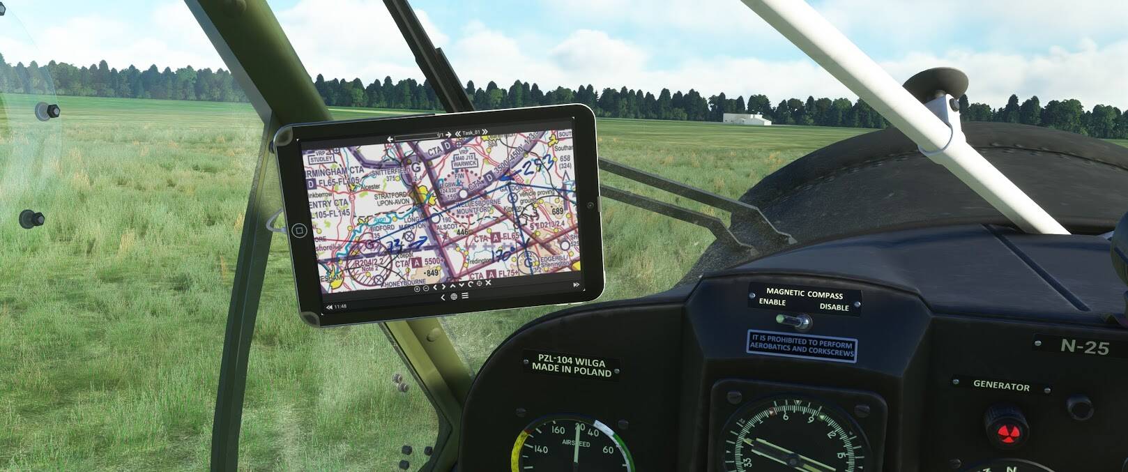
Worth mentioning that some planes have mods for full integration, like the Wilga. Instead of a floating window, Sy4sim is displayed on an iPad.
The developer is very active in Discord and will reply to any questions you have
Sounds great what you’re doing with the program. I wanted a program that could include among other things, ICAO, City, Airport search which it has…using the freeware. Is there a way within the Garmin 3000 or 5000 to find similar plate information to Navigraph which is required for VNAV, including minimums? I’ve been searching for videos or print to help me with VNAV as I’m a bit unclear about a few things.
For those interested, the latest version of Little Navmap VR can now display images saved inside the “companion” folder.
You just need to run companion.exe before launching MSFS (from inside the Little Navmap VR folder → bkiel-ingamepanels-lnm)
Works really well for scanned charts if you want to do old-school navigation
Found this searching… And I’m wondering: Does All in One v4 let you watch Netflix or listen to Audible audio books (Audible normally kicks out a separate browser tab/window for listening) in VR?