 Thank you using the Bug section, using templates provided will greatly help the team reproducing the issue and ease the process of fixing it.
Are you using Developer Mode or made changes in it?
no
Have you disabled/removed all your mods and addons?
yes
Brief description of the issue:
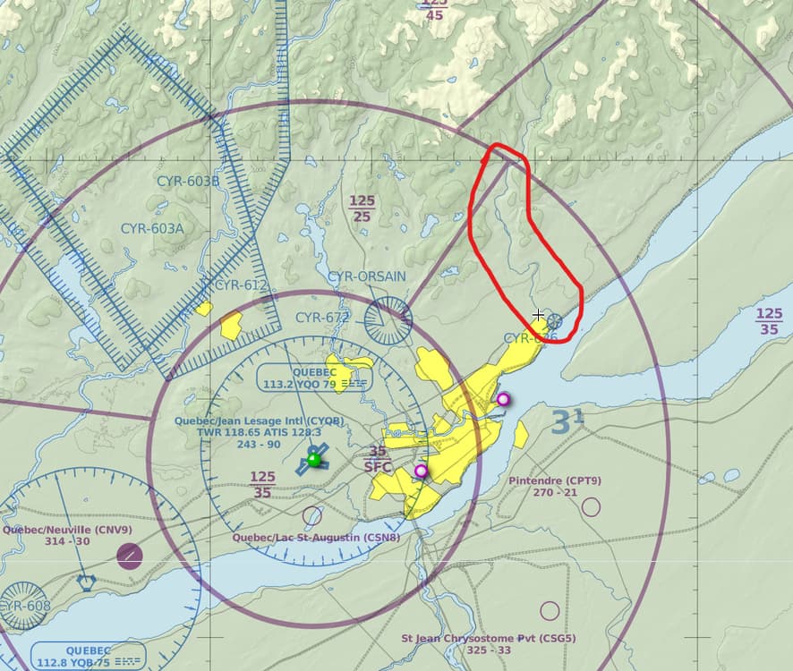
We have a bug at Montmorency River close to Quebec City just at te north side of Orleans Island. I hope that will be fix sooner. [46° 53′ 06″ N, 71° 08′ 36″ O]
Provide Screenshot(s)/video(s) of the issue encountered:
ICAO or coordinates (DevMode > Options > Display position)
Detailed steps to reproduce the issue encountered:
PC specs and/or peripheral set up if relevant:
Build Version # when you first started experiencing this issue:
 For anyone who wants to contribute on this issue, Click on the button below to use this template:
Do you have the same issue if you follow the OP’s steps to reproduce it?
Provide extra information to complete the original description of the issue:
If relevant, provide additional screenshots/video:
Montmorency River who is new POI on Canada update is underground ,We need to make correction for the elevation. Thanks for your support.
Do you have the same issue if you follow the OP’s steps to reproduce it?
Provide extra information to complete the original description of the issue:
If relevant, provide additional screenshots/video:
yep.. therefore I ask about you checked former for existing duplicates.. there are existing bugs around that spot..
one example with exact same spot
PS: and seem have nothing to do with the canada update
The problem is not at the bottom of the fall, but on the river who bring the water to the fall. I deleted all my addons in the community before I send my pictures. This issue was not there before the Canada update.
Do you have the same issue if you follow the OP’s steps to reproduce it?
Yes
Provide extra information to complete the original description of the issue:
Follow the river North from the Montmorency Suspension Bridge POI.
The bug extends at least 50NM North up the river and it’s forks, from Quebec City. It is nearly all sunken to ~MSL, and some is raised on a vertical sided platform 500ft above surrounding terrain.
If relevant, provide additional screenshots/video:
 Thank you for using the Bug section, using templates provided will greatly help the team reproducing the issue and ease the process of fixing it.
Are you using Developer Mode or made changes in it?
No
Have you disabled/removed all your mods and addons? If the issue still occurs with no mods and add-ons, please continue to report your issue. If not, please move this post to the User Support Hub.
Yes, all default here.
Brief description of the issue:
major canyon east of Lasage, splitting Canada in two. hehe
Provide Screenshot(s)/video(s) of the issue encountered:
ICAO or coordinates (DevMode > Debug > Display position)
13 miles Northeast of CYQB
Detailed steps to reproduce the issue encountered:
PC specs and/or peripheral set up if relevant:
Build Version # when you first started experiencing this issue:
Do you have the same issue if you follow the OP’s steps to reproduce it?
Yes
Provide extra information to complete the original description of the issue:
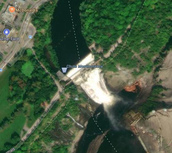
From Quebec City, follow the St Lawrence east, following Hwy 440. Just east of the junction of Hwys 440, 138 & 368 (crossing the river) is the Parc de la Chute-Montmorency. In the park there is a dam / weir just upstream from the St Lawrence river. See Pic #1 (Bing) & Pic #2 (MSFS). This forms Montmorency Lake upstream. The dam and bridge is modelled in the sim, but the elevation of the lake behind it is incorrect, being the same as the St Lawrence river. This causes the appearance of the “Canyon” noted by the OP. See Pic #3.
Partial Specs & current settings:
Build: SU15 (v1.37.19.0)
3rd-Party Addons: None, Community Addons: None
i7-12700K (No overclocking or undervolting), 32 GB 5200 MHz DDR5 CL40, Intel Arc 770 (16GB, v31.0.101.5445).
Graphics Tab: Full Screen 3840 x 2160 TAA, Render resolution - 100, AMD Fidelity - 150, VSync - On, FRL - 33% MRR (120 Hz), HDR10 - On, DX12B, TLOD @ 400, OLD @ 200, Motion Blur - Off, Other settings - all Ultra (Water Waves & Glass Cockpit Refresh Rate @ High).
MSFS Version: MS-Store, Standard, plus All World and City Updates
If relevant, provide additional screenshots/video:
Title of post changed from:
“Bug close to Quebec City”
to
“Incorrect water elevation on Montmorency Lake, Quebec”
to better indicate location and provide greater visibility in searches.
There are a lot of elevation issues in southern Quebec, especially in the Bagotville area. Northern Ontario along the Great Lakes have same type of elevation issues between the water and land.
![]() Thank you using the Bug section, using templates provided will greatly help the team reproducing the issue and ease the process of fixing it.
Thank you using the Bug section, using templates provided will greatly help the team reproducing the issue and ease the process of fixing it.![]() For anyone who wants to contribute on this issue, Click on the button below to use this template:
For anyone who wants to contribute on this issue, Click on the button below to use this template:


