I just had a chance to load the sim and test an area where a deep cloud layer is present in model data currently: Houghton County Memorial Airport in Hancock, Michigan (KCMX). This airport is on the upper peninsula of Michigan. Here are a few recent METARs:
KCMX 290614Z AUTO 12010KT 1/2SM SN FZFG OVC003 M03/M04 A2960 RMK AO2 P0001 T10281039 $
KCMX 290553Z AUTO 13009KT 1SM -SN BR OVC003 M03/M04 A2961 RMK AO2 SLP043 P0000 60001 T10281039 11028 21050 58018 $
KCMX 290500Z AUTO 12010KT 1 3/4SM -SN BR OVC004 M03/M04 A2963 RMK AO2 P0000 T10281044 $
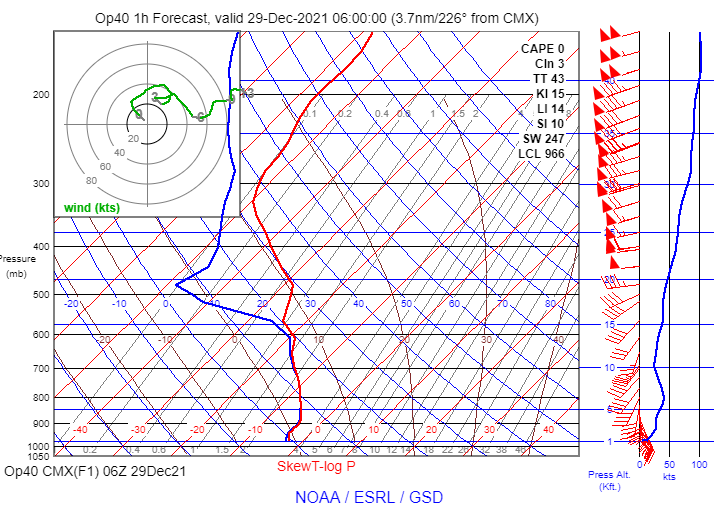
The RAP model sounding for 06Z shows a stable saturated layer between the surface and about 11,000 ft. MSL, and very high humidity from 11,000 ft to 14,600 ft. MSL:
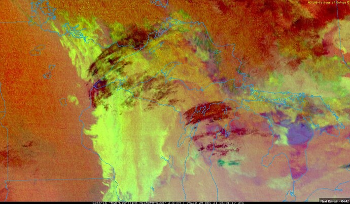
The nighttime microphysics cloud image depicts a combination of low stratus-like clouds with higher cirrus clouds passing overhead. It is difficult to see the layers clearly in the still image below, but the animated image shows the pattern unmistakably.
Here is the view after loading into the sim at a parking space (I adjusted the time of day to allow for easier viewing of the clouds and weather):
The in-sim METAR has not yet updated to the observations near 06Z, but conditions haven’t changed much in an hour according to the recent METARs shown above. The sky condition was nearly overcast, but there was one notable break in the clouds passing overhead, as shown above. The cloud formations visible through the break look suspiciously convective.
I used the drone camera to quickly climb through the cloud layer. As I expected, there was a single thick cloud layer extending several thousand feet up from the surface. I had to climb for a surprisingly long distance before I could no longer see the ground. Once I broke out above the clouds, this is what I saw:
These clouds are clearly convective in appearance, and there are a lot of individual towering clouds spaced relatively close together. Based on my tests of the cloud drawing parameters in the original post, it looks to me like the sim is using a scatter parameter above 0 here. If scatter=0, the cloud tops are much more uniform. There are also noticeable breaks between the clouds, indicating that coverage was not set to 100%. The ash-like appearance of the cloud tops suggests the density parameter was relatively high, but on the other hand, I needed to ascend far into the cloud before the ground disappeared. That suggests the density of the lower part of the cloud was low. Since this was a single contiguous cloud layer, I don’t think it’s possible for two density parameters to be used at different heights.
In any event, it is certainly possible to create a stratiform layer between 300 ft. AGL and 11,000 ft. AGL with scatter=0, coverage=100, and density = 1:
Even if the coverage is 90% instead of 100%, the clouds look reasonably stratiform with scatter=0:
This example confirms my suspicion that the cloud engine’s default behavior is not properly tuned for thick stratiform clouds, which leads to overproduction of convective cloud types.


