Is Flight Planner somehow broken or is it me being dumb?

Hello there!

I am really trying to understand how the modern aviation works these days and I try to follow all the rules in this matter. However, I am struggling with NavLog and/or Flight Planner in general.

I have made an ambitious plan to fly around the world in Daher TBM, visiting 500+ airports on the way. But I really don’t know how should I setup my Flight Planner. As I am aware, GA aircraft usually fly with VFR, but I would like to do IFR flights along the way. Obviously, flying TBM, I choose low-altitude airways. But then I hit the wall of misunderstandings.

As far as I know, it’s more suitable for ATC to “get rid of” GA aircraft from the airport as quick as possible to avoid clogging the routes which airliners are usually following. That’s why I choose direct departure and arrival on my flights, with only approach chosen manually (ILS or RNAV if possible). It would be more realistic probably to follow SIDs and STARs on longer flights, but on short trips (less than 70-80 nm) it is pointless, because the total distance to cover rises sometimes twice because of all the maneuvers.

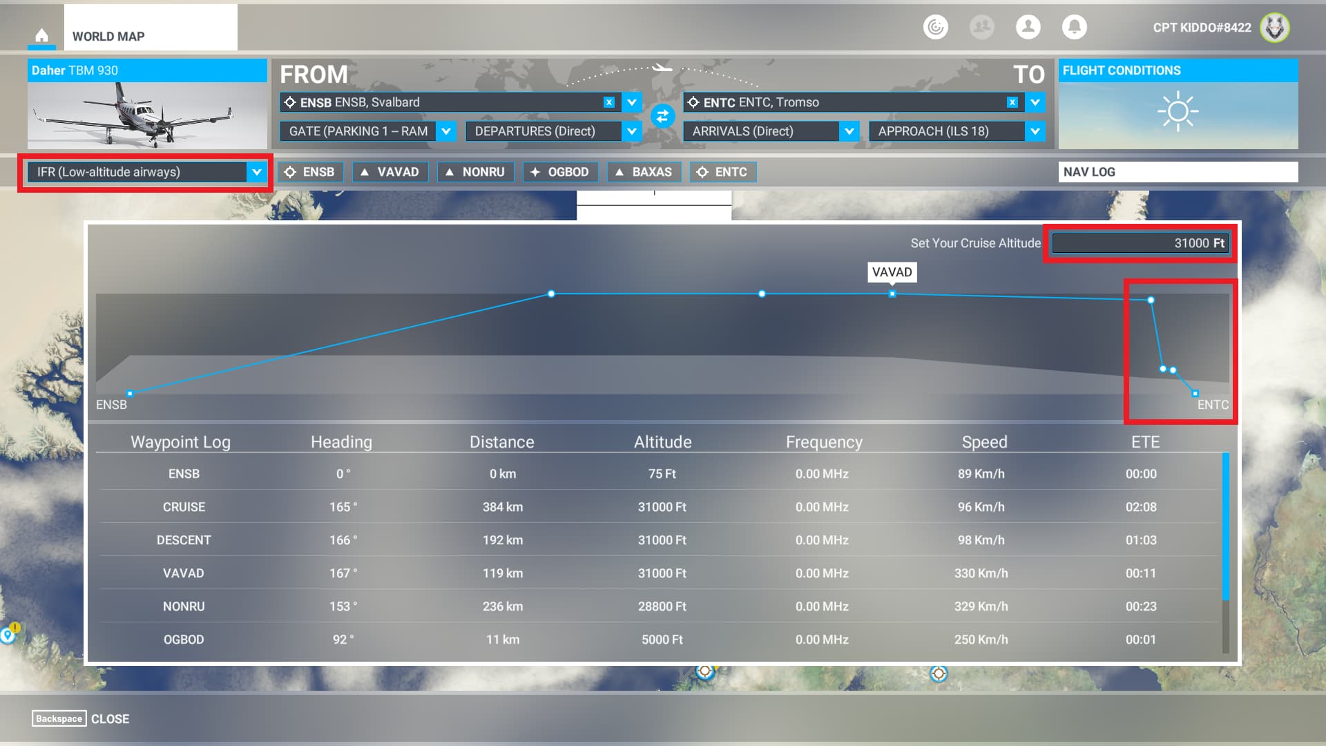
And then the NavLog enters the scene. Usually it works more or less correctly, but sometimes - as you can see on the screen provided below - its shows some nonsense. When I plan a flight from Svalbard (ENSB) to Tromso (ENTC) with direct departure and arrival, but with ILS 18 approach, it shows some absurd values. Am I really supposed to descend almost 24,000 feet within a minute to OGBOD from NONRU? And as far as I know, LOW-altitude airways should not be executed at 31,000 feet of cruise altitude.

I don’t even want to mention a problem with units and speed values - cruise speed of TBM is 96 km/h (52 knots), according to NavLog, and because of that, ETE of the whole flight is 4+ hours…

Can someone explain these absurds? Or maybe that’s me who is not informed enough to use Flight Planner correctly? I will be very grateful for any advice.
Thanks!

Screenshot:

This is not true, most GA aircraft are equipped with the required instruments for IFR flight.

This depends on the SID / STAR, you need to review the charts to see if there are altitude and or speed restrictions. If there are, and your aircraft can’t meet them, you cannot fly the procedure.

There are also equipment restrictions “turbojet only” etc…

Charts are your friend.

Scrap the in sim flight planner, use something like Navigraph or Little Nav Map.

1 Like

AFAIK there are no FAA regulations or restrictions about the use of High altitude vs Low altitude charts. (Not sure about ICAO.) There are obvious differences but there are subtle differences also. The charts are designed differently for different users, High altitude for jets and airliners, Low altitude for pistons. (Whenever I fly 50 to 350 nm in an airliner I always use Low altitude charts. I don’t want to fly to 30,000 ft for a short trip. And when flying the C172 cross-country, I won’t use High altitude charts due to the performance limitations of the C172.)

Planning an IFR direct route between airport A and airport B should be easy for MSFS but the MSFS Flight Planner is not designed for direct IFR routing. IFR users have to use either the High or Low altitude routing. “None” is not an option. This does not mean that the Flight Planner is broken. A 3rd-party flight planner might work or manually editing the flight plan.

Your question about the sharp descent from 31,000 ft in the Flight Planner is valid. However, the Flight Planner is doing what you are requesting. What is your plan to descend from 31,000 ft to the ILS initial fix assuming you will be using the autopilot without using a STAR? It is possible to request a stepped descent from ATC but you are still responsible to determine when to start descent.

1 Like

The MSFS flight plan is still very incomplete… If were possible to edit the speeds and altitudes of waypoints to calculate the TOC, cruise and TOD it would be much better to have a more accurate idea of the plan, if we could create waypoints on the map and naming them, set altitude and speed would be perfect. Unfortunately we can only create but without customization. Yes I know you can make a plan on paper and pen, use a external software /addon and in fact I even like do it with pen and paper when I do VFR flights in the sim but I believe the simulator itself should have these options.
The NAVLOG that you open while flying is also a mess haha.

In FSX if I’m not mistaken you could customize the waypoints, when I started playing MSFS I was surprised that this feature didn’t exist. Just like the mouse yoke and so many others…

You’re not dumb, it’s the simulator that has one more incomplete feature.

1 Like

Thank you very much for all your answers.

I am still trying to strike a balance between realism and pleasure to make my around-the-world trip the greatest. I had another idea some days ago: to fly as low as possible to see as much of the world as possible. I’ve read lots of publications to find out the lowest altitude allowed in certain circumstances etc. and was wondering if I can apply that to MFS.

And that’s the moment when another question rose in my head - do you usually use a built-in ATC during your flights? I wanted to test my “altitude idea” and see if ATC is aware of surrounding terrains, so I set a flight from VNLT (Langtang, elevation of 12,000 ft) to VNLK (Lukla, elevation of 9,000 ft). And the controller instructed me to climb and maintain 3,000 feet after take-off…

So I tried to follow my own waypoints, but again - I can’t set an altitude I would like to pass it over - in Flight Planner I can set only a general cruising altitude, not a specific one for each of my waypoints. Dayum, shouldn’t it be easier to plan a flight in Flight Simulator? :face_with_spiral_eyes:

Realism vs. Pleasurable has always been intensely discussed since MSFS was initially released.

Many sim-pilots use 3rd party ATC products to enhance realism. All of them have their strengths and weaknesses that also have been debated many times here. The “search” function should help you find posts/topics of interest.

One of the strongest features of 3rd party ATC is the ability to actually talk with someone making it as realistic as possible.

The built-in ATC is text based that is displayed and spoken which is clunky at times and not highly realistic. However, it is very structured and uses FAA/ICAO terminology. It is a good way to learn how to communicate with ATC using specific ATC terms and instructions.

How ATC communicates altitudes is another huge topic. In the past ATC used to give crazy altitude instructions depending on who created the flight plan. It works a lot better today using SID, STAR, and approaches altitudes correctly. Probably the weirdest instructions I hear these days is when flying a missed approach, there is a hand-off to a Departure controller. They issue an climb instruction to 10,000 ft. Ten seconds later, they see that you are flying a missed approach so they will then issue instructions to descend to 4,000 ft and then a vector to restart the approach. One other issue is the “Cruising Altitude” in the Navlog/Flight Plan. There is no error checking by ATC. If the cruising altitude is 32,000 ft and you are flying a C172, there is no way for the aircraft to go that high. However, ATC continues to issue climb instructions because they don’t know you are flying a C172.

There are jets and airliners that do not import MSFS flight plans directly into the FMS. Vendors usually have their own process to import various flight plan formats. Also, many people will take the time to manually type in their flight plan. Two-way communication between the FMS and ATC is not very well implemented yet.

Finally, you asked about two high altitude airports. If you fly VFR direct between the two, you are responsible for flying around obstacles, mountains, clouds, and other aircraft. ATC will not issue low altitude alerts. If you use standard IFR charts and stay on a published airway, ATC normally issues correct altitude and speed restrictions. If you fly direct from one waypoint to another not using published charts, you no longer have any altitude protection from ATC. However on IFR charts there are minimum obstacle clearance altitudes published for each sector. ATC doesn’t use these altitudes but you should when planning your flight.

I have flown one specific published STAR where ATC issues vectors to the assigned approach. The destination airport is in a valley with high mountains on each side. For some reason ATC gives me vectors that are too low and crashes me into a mountain. One reason for the problem vectors is the speed of the aircraft. Airliners make wide turns avoiding the mountain. Small aircraft fly slow enough to make small turns avoiding the mountain. This is the only instance I know where ATC flies you into a mountain USING VECTORS. There may be others that are repeatable.

Finally, you mentioned going around the world. MSFS has only one ATC but the world often has a separate ATC for each country or region. Every time I cross an ocean I seem to always be in contact with ATC. IRL VHF signals cannot span oceans so aircraft use HF or satellite communication neither of which are in MSFS.

1 Like

Thank you so much for your contribution, PacificSet, you’re helping me a lot!

So I decided to make a test flight from EPSY (Szymany) to UMMG (Grodno) using only MFD on Daher TBM. It all looked fine from the beginning. I also choose an approach straight in MFD (ILS 17). I was assigned 7000 feet for that flight.

At one point an ATC asked me to prepare for ILS approach but via GRD transition, so I changed it in MFD. It all went well, I descended to 4000 feet and waited to catch the glideslope on final straight. But it didn’t happen. I soon realized that I’m too high, so I began to descend without autopilot to quickly get back to more-less proper final approach, but then ATC reminded me that I should stay at 4000. So I obviously missed the approach.

Is it common that the aircraft does not catch a glideslope? It was all set correctly (ILS frequency set, AP set to LOC1 & APR), but the “GS” sign never changed to green and that little green marker was below the center on the altitude screen. And again, why that ATC told me to stay at 4000 even if that meant missing the airport completely?