Hello All,
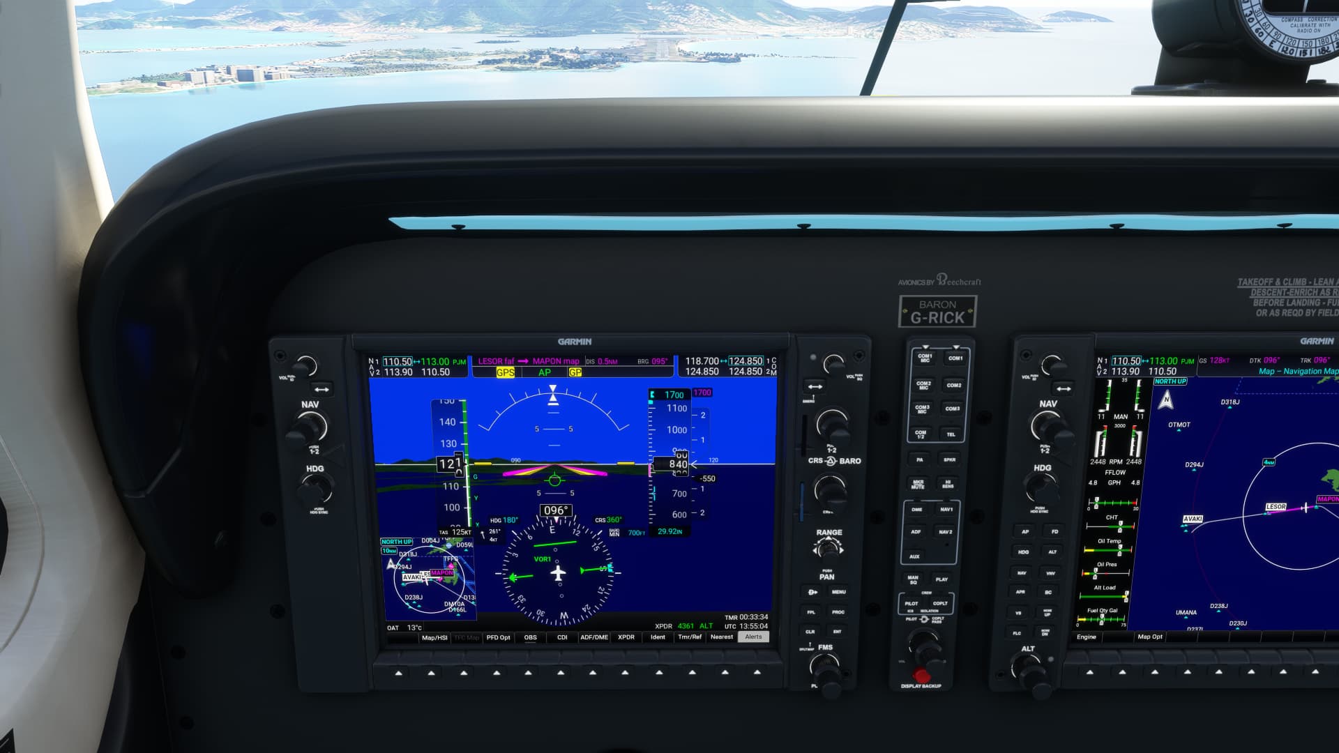
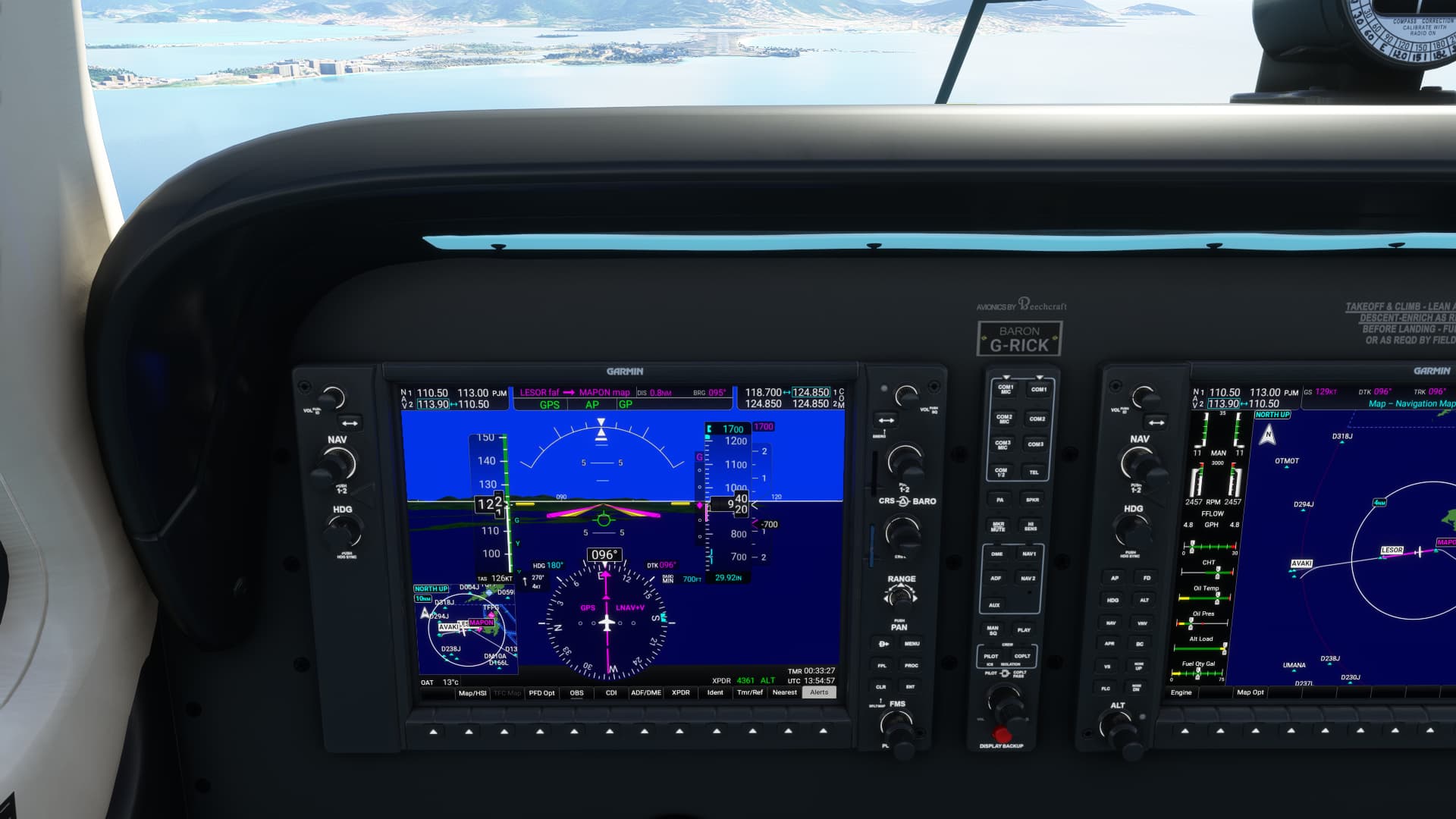
Since the recent couple of updates, VOR DME has always pointed due north for me. On the screenshots attached, I’m doing an RNAV approach into Princess Juliana on Saint Martin. You can (hopefully) see that I have NAV1 tuned to 113.0, and that the plane has recognised that as PJM (Juliana). However, during the final approach - when I am still 2.5 miles from the runway - if I switch the CDI from GPS to NAV1, it points due north, when then GPS was showing east! You can see from the Navigraph chart that the VOR is right at the runway’s threshold, so surely - at that distance - the green arrow should point in the same direction (more or less) as the GPS CDI in the other pic? Any help would be appreciated, as it is making VOR navigation impossible for me. ILS DME still works, though.
Thanking you all in adance for your sagacity.
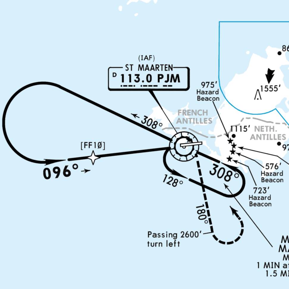
In this mode, you have to set the CDI manually to the appropriate radial using the CRS knob, in this case 096 for your final approach.
OK, thanks for the response, but that raises more questions. WHEN would 096 need to be set? When you’re over FF10? By that point, you’d have the runway well in sight, and what would be the use of VOR for that situation, when VOR is meant to be useful from 20+ miles out?
Well, there are certainly several methods to set up this approach, but over FF10 is definitely too late. I’d personally already dial-in the final course when leaving the holding for the outbound leg. When passing the VOR, I’d start the clock for the 2 mins outbound and fly the outbound radial 308 using either the simple bearing needle on the HSI or nav2. You can then easily intercept the final course.
The purpose of the approach is to get you below the cloud cover. You start the approach at 4000, so let’s say you have a ceiling of 1500, you can use this approach.
1 Like
There are a couple of things here that are contradicting each other. You said you are flying the RNAV approach but the image you posted is from the VOR X chart. So, the question is, which approach are you actually trying to fly? As the previous replies have already stated, you need to set the CDI to the proper course as soon as you tune and start navigating by the VOR signal. How I would fly the VOR X approach would depend on from what direction I was approaching the airport. If you are actually flying the RNAV approach, you don’t need the VOR at all.
2 Likes
I’m instrument rated and I’ve flown this approach. I would have 308 set inbound to PJM in the hold, once I crossed the VOR outbound on a 308 heading I’d twist the knob to 096 so I could intercept the final approach course inbound on the turn. That 096 inbound course to the VOR is what tells you when to roll out of the left-hand turn.
That’s off the top of my head. I’d have to look at the full plate.
1 Like
So this is very interesting!
Firstly, my issue is not seeming to get VOR to work. Nothing to do with what approach I’m using. I’m just trying to understand why I can’t tune in to the VOR at Juliana (and anywhere else), even though the plane has clearly picked it up. I included the Navigraph chart to show the location of the VOR: that’s the only reason the chart’s there. The only reason I picked an RNAV approach was to get lined up with the VOR, to see if I could pick it up.
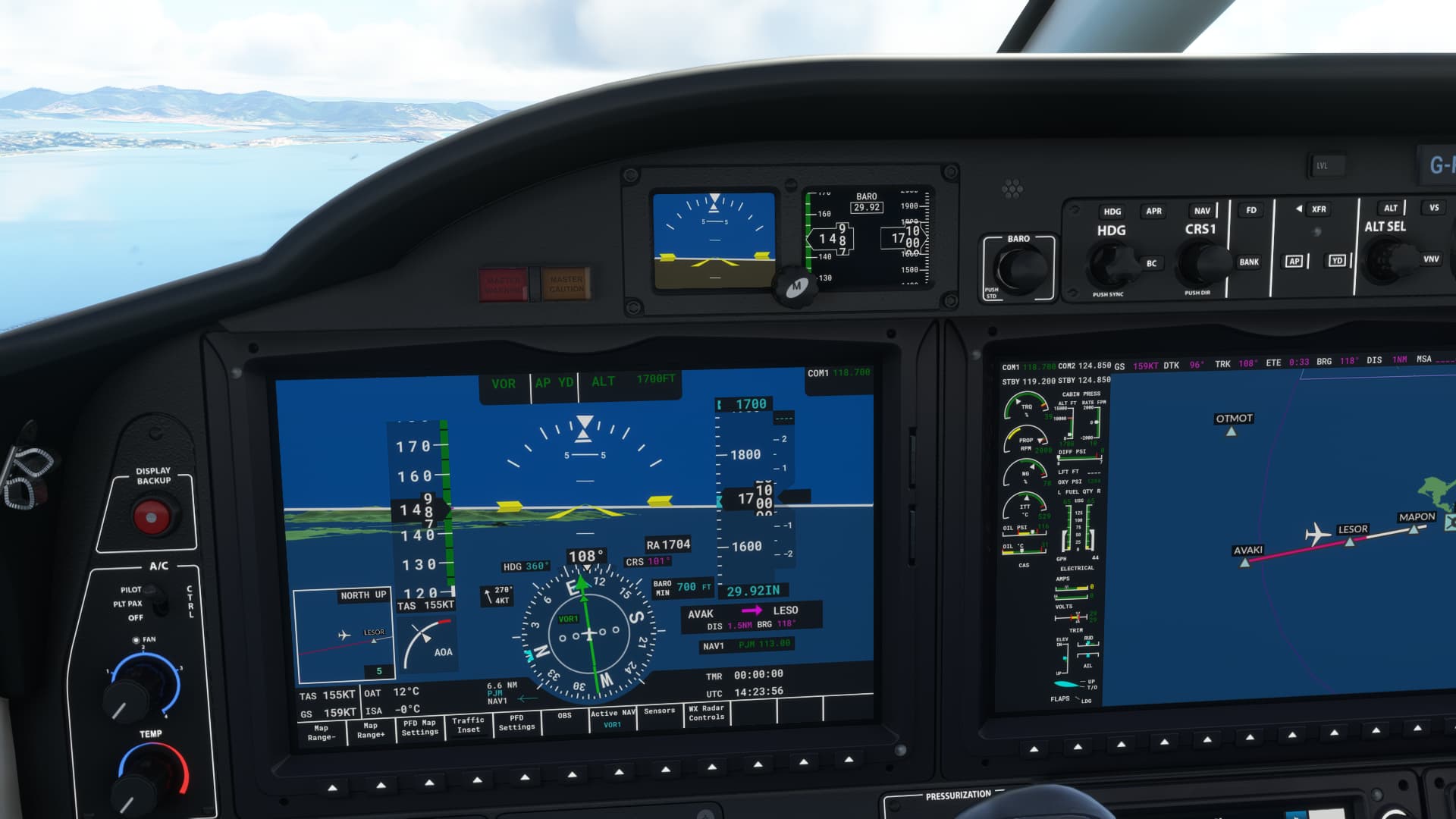
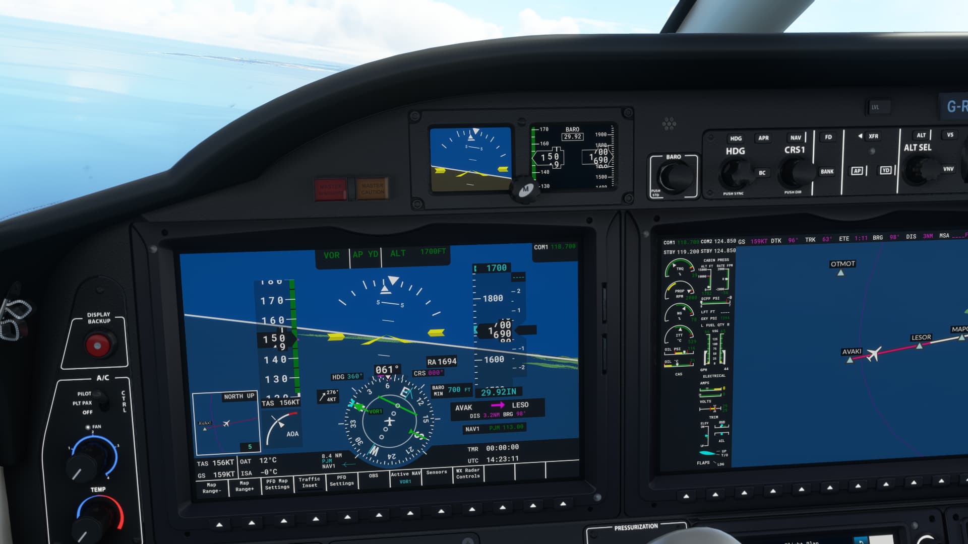
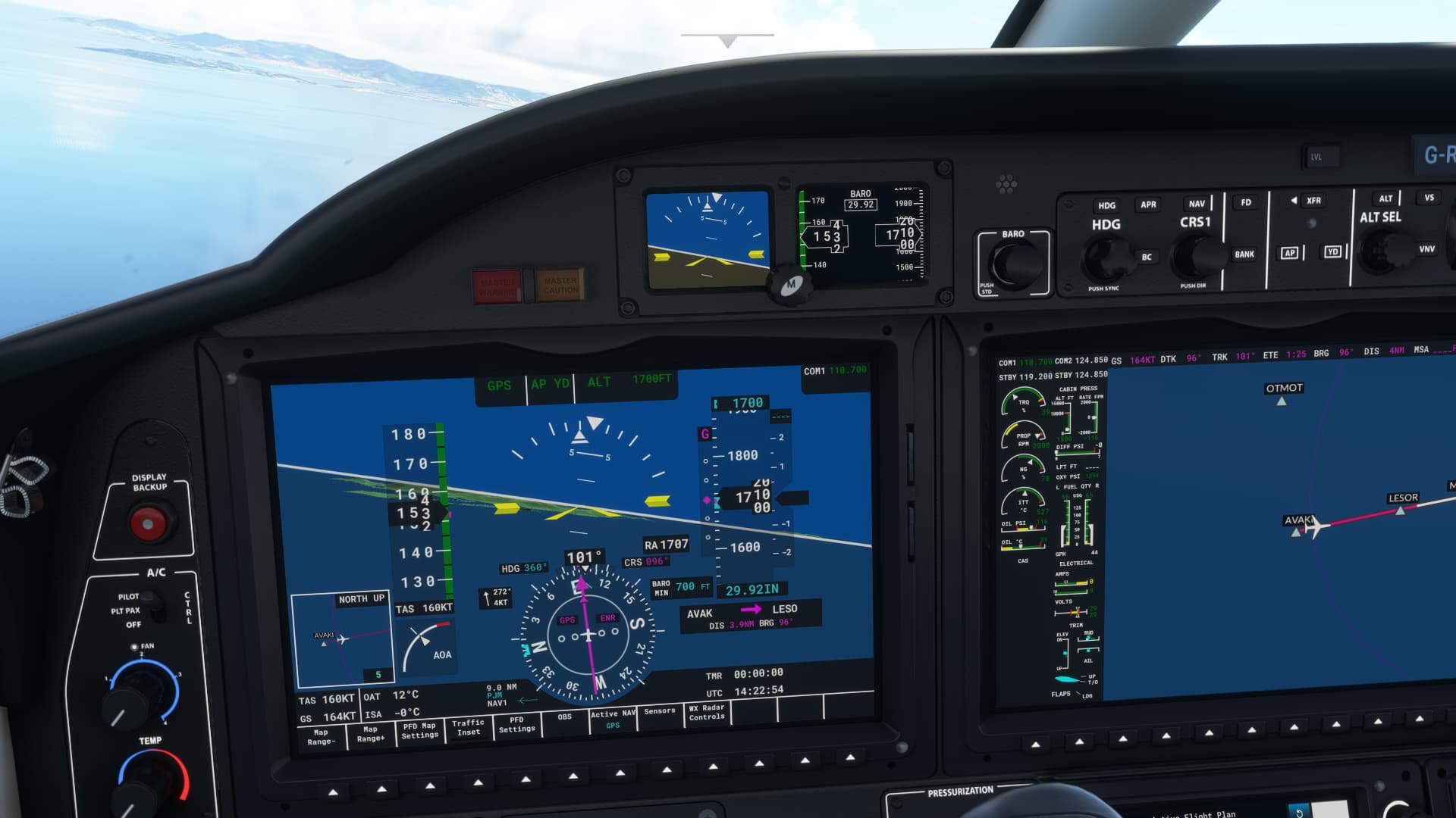
I tried the same flight again in the Daher, and I got something similar, but different: bottom pic here shows the GPS in purple with the VOR arrow in blue exactly behind it, POINTING DIRECTLY AT THE VOR. (I’m not shouting - that’s for emphasis). Middle pic shows the switch from GPS to NAV1. Blue NAV1 arrow still pointing at the VOR and the green arrow pointing due north. Top pic shows us lined up with the VOR, as I’ve fiddled with the CRS knob to line them up.
Is that the way it’s supposed to work? If the plane KNOWS where the VOR is (blue arrow), why make the pilot fiddle with CRS to fly to it? Or am I missing something? And in the Baron, there is no blue arrow, so how do you know when to use the CRS?
Thanks for replies, seems I’m getting closer to understanding this.
@ MarfeDragon
Hi,
I see this RNAV and similary also VOR approach little bit differently. let do talks as VOR approach for first, that racetrack is there for arrival and correct start/init of approach. This racetrack simply define how you need enter approach for last left turn to final track, simply imagine that any IFR aircraft approaching this airport and want use this VOR approach, due actual course to VOR from it’s flight/last fix on route, it needs do correct enter of pattern. All depends to it’s course to VOR as I said from actaul position. Here i recommend web for enter pattern from any course/direction. Let say aircraft arrive to VOR exactly from N. Then it need simply pass VOR and use safe course to then do left turn and not overfly inbound radial to VOR → 308 deg. I can say it can do that cutted line track what is Missed approach procedure, it definitelly is suitable to have enough time to do left turn and not overpass radial 308 deg. After pass VOR (aircraft can have course to it let say 310 deg.) it need continue that defined outbound radial 308 deg. With enough distance and correct hight not lower as defined at chart, it need set inbound radial 96 deg and with doing left turn to catch it and stay with it, it is on final track now. And now something what you didn’t post but is very important. I don’t know this approach plate but with VOR/DME approach you have there also descent profile and minimums per distance at final track. be careful here, you never fly lower as is defined and allowed as chart shows! All due DME distance of course, i expect it on chart. At some point defined as MAP (defined distance and minimal height) and you still don’t see runway, you need cancel landing and quickly follow that dashed line track to not crash at terrain ahead, it’s described there, therefore is also inbound track 308 there what you simply also due terrain conditions must never overfly. I expect of course due this kind of approach that MAP will be defined enough distance before runway treshold because of this approach type and also terrain conditions around airport. Coclusion? Your approach plate has another important data what we don’t see here but I’ve described to you what’s matter here. Altitude minimums and exact course required here as safety! Happy flights 
Update: maybe just again one hint, this is RNAV or VOR approach, no ILS so you need hold your altitude and descent manually in case of VOR approach, as chart with descent profile and minimum heights at parts of final track allows. You can have simply only freq. of VOR set (NAV1 or NAV2) but DME you need have functional! Without that you simply can’t do this approach. With RNAV approach you will have all defined also descent profile (IAN probably) and you can use also APP autopilot command that will fly descent also for you like ILS. Either RNAV or VOR/DME approach will use that racetrack to set correct init procedure to go to final track. Yes, you’ll need check difference of RNAV and VOR/DME approach plates but hope my description is ok for you and only drilling and training will have benefits to your skills.
Update2: aaaah ok, now i see your cockpit n1 screenshot what shows probably your test in final what NAV1 shows with freq of VOR. You have already good answer, you need in this case turn Course knob to expected course. On screenshot2 I see your RNAV approach, ok. Again, I don’t know that plates to PrincesoJ airport but from that screenshot it looks to me like RNAV app. No problem with next talk if you want.
1 Like
In answer to the topic question. It’s you not the sim. There are many good explanations here already but here are a couple of extra bits of info to help you along.
For radio based navigation it’s always been required for the pilot to dial the intended course. Some equipment makes it a bit easier by providing a means to centre the needle. The G1000 is one such device. To centre the needle just push the CRS knob.
On another point the Baron and any other G1000 equipped aircraft does have the equivalent of the blue needle that you refer to from the TBM. This is called a bearing pointer. Use the soft keys along the bottom of the G1000 bezel to turn a bearing pointer for Nav1 on and you have a pointer to that station.
1 Like
This might help you out. There are heaps of other videos on there as well.
And if you really have time watch these and you will be an expert:
1 Like
The aeroplane doesn’t know what course you want to fly to or from the VOR, it only knows where the VOR is. That’s why YOU set the course based on the approach you are flying. It’s not like an ILS where a single ILS frequency is ONLY associated with one runway and one course. The one VOR at an airport might be used for many different approaches as well as for high altitude flights overhead so you need to set it based on what you are doing.
2 Likes
Thank you so much for all who replied. So it IS me, it’s NOT the Sim, that’s how it works, and I misunderstood it. 400+ hours in the Sim under my belt, and still so much to learn! Right, I’m off to watch those videos ^^
To be fair, modern avionics tend to blur the lines a bit between ground based navaids like VORs and area navigation systems like GPS. In a suitably equipped plane you can enter a VOR approach into the FMC and it will fly it perfectly without you having to tell it what the inbound and outbound courses are, but this is a case of the FMC using all of the position information at its disposal to follow the track from its database, it’s not actually selecting a course on the VOR and flying it. You do have to have the VOR displayed somewhere so you can monitor the FMC’s performance though.
1 Like

")

