I am currently bush flying in Colombia, inspired by this documentary https://www.youtube-nocookie.com/embed/VqPIqn1upqs
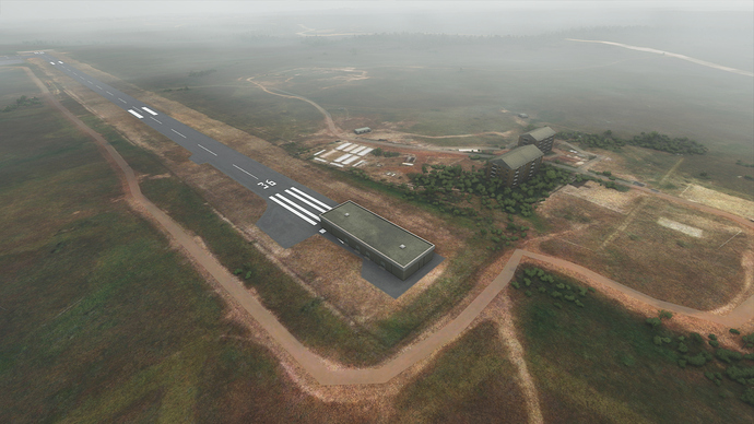
After landing in Guerima (Bing-map-view), I was suprised to see all the ground in some generic green.
This is obviously no sat or aerial data from Bing…
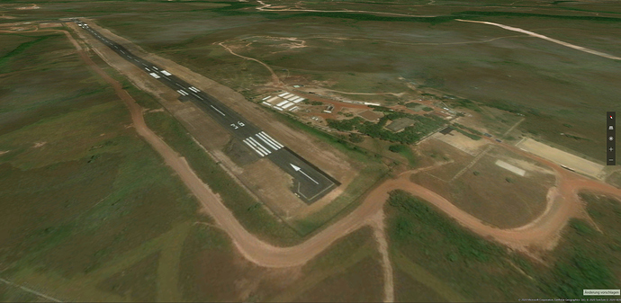
The data publicly visible on Bing maps shows nice ground textures with sandy roads and a clearly visible runway, also the little village is looking totally different.
The shape of the village looks accurate in FS, but the AI totally failed to interpret the data, now showing large warehouses instead of huts with intermitting green and trees. This is neither a satellite ground texture, nor is the AI doing anything good here. The positions of buildings doesn’t even match. It rather looks like generic autogen, nothing wich could have been worth to be downloaded…
Pretty disappointing ![]()
lmao , 510.1 million km² surface area of the earth how could they not get these buildings right omguddddd , refund refund lol
Serious though you have any idea how big the earth is ?
Earth is approximately 510 million square km (5.1 x 10⁸ km2) or 196,900,000 square miles.
I think they did good. I’d rather have generic green & forests than ugly cloudy aerials.
Probably because of the clouds, the AI replaces patches that have clouds in them with generic patches using synthesized textures. Hopefully in the future there will be satellite images without clouds for the region. It would also be great if they could make the generic patches with synthesized textures more interesting so they feel less generic and uninteresting.
That could very much be the reason for this, I agree
Also, not all parts of the globe are covered by aerial photography of the quality that the AI would need to make the best choices about the buildings. It may be cloud cover on the day of the pass, but it could also be that they’ve just not got round to that area yet, with only satellite coverage available.
Bing is being updated regularly however and I would expect at least some of those areas to be better covered.
Here watch this and maybe you can get a better idea what they really are doing.
and just because you don’t like someones reply doesn’t mean they are a troll…
Good to see you found it. So you now know the Earth could be the size of Jupiter and it wouldn’t matter.
Sigh! ok you have your mind made up on how it all works and nothing anyone can show or tell you will change that…
For another thread (where we’re unhappy with the ground textures which aren’t nearly as good as Bing has them) I made this side-by-side comparison which shows that at least in some parts of the world (here Mainz, Germany, a few miles out of EDDF Rwy 27), it’s exactly the same satellite picture. Note the dark/light edge diagonally across the fields.
Not true. I am entirely thankful for contributions of value ![]()
Yes, like LMex said, it all depends on the quality of the source images. Somehow, Google managed to collect mostly everything without clouds while bing has still a lot of work to do.
When the Blackshark AI fails at the same time, your are back on P3D/FSX autogen quality.
I guess the Blackshark AI needs even more work than bing maps. Then the occasional cloud masking ground textures could be acceptable as well.
The Oak tree outside my house is not in game wtf … and my driveway is pavement when in real world is gravel , come on Bing Maps
But at least they got the Hoffellsjokull Glacier right ![]()

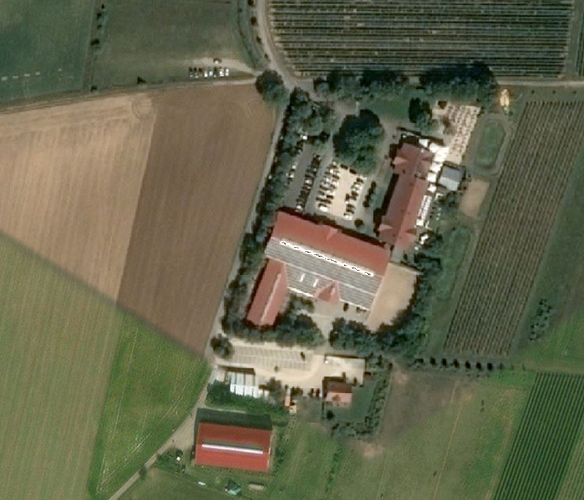
@Phustekuchen The Bing image quality is not really the problem. The farm in the picture above could be shown like this if there is enough memory for it:
Whatever mistakes the Blackshark AI makes can thankfully be fixed in the Azure cloud, independent of the update cycle. Personally, I find the AI mistakes mostly rather cute: I flew over Wales today and all the modern Welsh barns have been turned into four-storey office buildings.
Someone posted this in the #screenshots channel on Discord… ![]()


