Please tag your post with #pc and/or #xbox.
Done
Are you on Steam or Microsoft Store version?
Store
Do you have any add-ons in your Community folder? If yes, please remove and retest before posting.
N/A
Are you using Developer Mode or made changes in it?
No
Brief description of the issue:
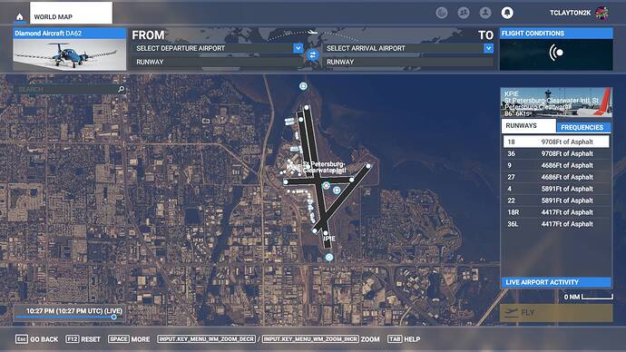
There are twice as many runways at KPIE than in real life!
Provide Screenshot(s)/video(s) of the issue encountered:
Detail steps to reproduce the issue encountered:
Pull up the airport in the World Map
PC specs for those who want to assist (if not entered in your profile)
In my profile, but N/A anyway - not performance related
Build Version # when you first started experiencing this issue:
Current - 1.19.8.0
Are you on the Steam or Microsoft Store version?
Store
Did you submit this to Zendesk? If so, what is your ticket #?
Should I even bother?
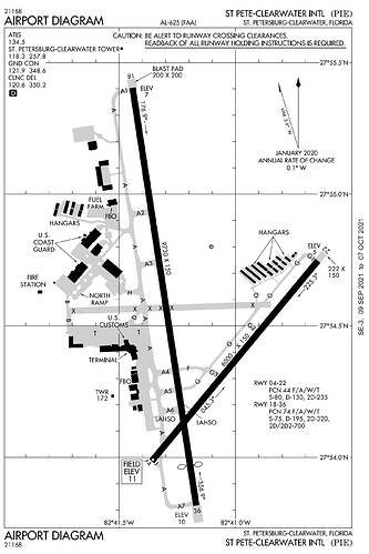
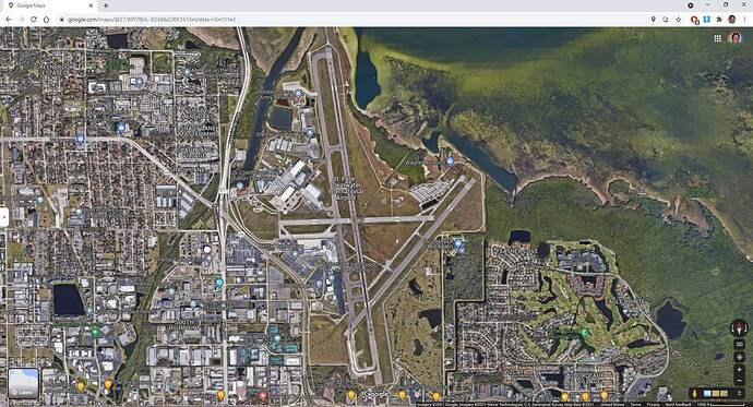
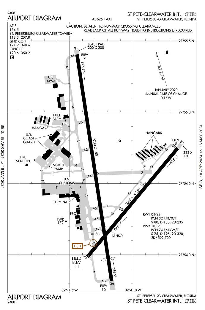
In the sim, KPIE has two runways that don’t exist. 18R/36L is actually just part of Taxiway A. It has never existed as far as I can tell. Runway 9/27 has been closed for at least as long as Google’s imagery is old - likely years.
Current FAA chart:
Current Google sat view:
Sad that this airport can be so wrong in the sim.
I just flew out of KPIE last night with the simulator up to date and no add-ons.
The airport is still not up to date more than 2 years on from this post.
There needs to be a public, crowd-sourced ability to modify basic airport layout information like runways and taxiways. Absolutely immersion breaking to be trying to use current charts with an airport so out of whack.
2 Likes
Still amazes me though that the base sim has this so wrong. Not like it’s some back woods airstrip or something.
The sim uses a pretty old database for lights and runways. If a runway was temporary closed at the time the database was scrubbed, say for construction, it’s closed in the sim. The lighting configurations are at least 15 years old.
The crosswind runway 9/27 and parallel 18R/36L at PIE were still open as late as 2014. By 2015, the parallel was being turned into a taxiway, and by 2016, 9/27 was permanently closed.
1 Like
Wrong as a current standing, up-to-date airport. Both of the so-called “nonexistent” runways actually did exist and have since been decommissioned for some time now. 09/27 being the more recent runway to go, I recall driving past the airport in the mid 2000’s seeing X-lit signs to mark the runway as inoperative to aircraft in flight and on the ground. As for 36L/18R, I can say for sure based off of a few older charts my grandfather had, that runway also existed. It may have existed as a marked runway later than I imagined, but since the runway wasn’t visible from the perimeter of the airport, I can only assume it either went at the same time as 09/27 or much earlier.
As for an accurate, up-to-date scenery, I have my hopes high that Verticalsim will deliver us the goods we’re craving sooner rather than later.
The current standing, as you put it, is really the only thing that matters does it not? We have only 2 operational runways at KPIE and in the sim there are 4. I know the history. I’m from the area and it is my base airport. VerticalSim has done a great job with other airports in this area and I’m very much looking forward to their release of kpie. Their facebook says this week actually.
I have looked into using the World Hub (now in Alpha) to change the in-sim KPIE to eliminate the two runways and make it match the current FAA Airport Diagram. Unfortunately, it appears I can’t take it any further with the World Hub because the in-sim aerial is an old one, at least before November 2023. But you may have read in this forum that old aerials have been an issue with the World Hub, so maybe newer aerials will be available soon.
There are two approaches: 1) If someone can send an FAA Airport Diagram pre-November 2023 or 2) when MSFS gets an updated in-sim aerial, the work can proceed. The World Hub rule is that any submitted airport must match the in-sim aerial.
I might also look into putting an update on FlightSim.to one of these days, but I make no promises.
Scroll up - I posted a chart from 2021. This board won’t let me upload a pdf though.
1 Like
Thank you!. Hopefully this one will match the in-sim aerial.
I went back to the FAA’s source page and downloaded the current chart. The only difference is that there’s now a Twy C Where the west end of the old east-west runway was, and there’s now one more Twy A spur at that same location, which bumps all the other A spurs up one number.
Unfortunately, even the version above from 2021 is too new. It is older than the one shown in the World Hub but does not match the in-sim aerial when I load KPIE in MSFS 2020.
World Hub (This one matches what is shown in Bing Maps):

In-sim 4/25/2024: Since I’m in the middle of working on KPIE, I can’t make a screen shot of what I see in-sim. But if you look, you should see that it doesn’t match either of the airport diagrams shown above.
I am making a version of KPIE using coordinates taken from Bing Maps. It “should” match the new version once it is available in-sim. Yesterday in the Developer Update Jorg indicated they would be updating U.S. aerials to 2023 versions for MSFS 2024. I’m guessing that is the version we see in the World Hub aerial now. But we don’t know if this will appear in MSFS 2020 prior to the release of MSFS 2024.
I will try to get this new version approved in the World Hub, but the rule currently is that submitted airports must match the in-sim aerial. However, I’m using coordinates, not the aerial, to locate changed taxiways. Maybe this will make a difference and get it approved?
There is a version available on FlightSim.to but comments indicate it has caused issues. I haven’t tried it myself. Perhaps there are other websites where I could post the airport version I’m working on once it’s done. Please let me know if you have any suggestions.
A major flaw of the world hub idea is the notion of aerial matching. The problem is we don’t know the date the photo was taken. And even if we do, we don’t often have corresponding charts to that version, so any redesignations that occurred between the two versions may cause a mismatch. Thus, we’re eyeballing everything, sometimes on aerials that are really hard to see.
Then, all that work we did realigning to a different version, looking up old charts or other aerials, etc, to distinguish sometimes the more difficult aerials, is nullified when a new aerial pops up.
TBT, editors really need to know when the aerial changes, and when the new aerial was taken.
1 Like
An “almost” up-to-date version of KPIE was submitted via the World Hub and approved today, so it should be in the May Airac release, on or soon after May 16.
Unfortunately, I couldn’t find a completely up-to-date aerial. The one currently shown on Bing Maps is what was used, so taxiways C and A4 are not included in the update. But otherwise, changes were made using coordinates from Bing Maps, so it should match what you see there and in the latest FAA Airport Diagram (above).
1 Like
