This is on the list for a long time already and its a lot of work.
I might add this in a future release but not soon.
Alex
6 Likes
I recently started enjoying disabling all forms of GPS when flying.
LNM is able to support this well by allowing to hide the aircraft in the map. However, the active leg of the flight plan is still colored magenta. Is there a way to prevent the active leg from getting marked?
I would like to keep the sim connection on as I like to study my breadcrumbs after the flight.
1 Like
Just do not enter a flight plan.
1 Like
I appreciate the reply, but that would be a very limiting workaround.
Part of the fun is determining where I am using visual landmarks and land-based navaids. From there I check how far I am from my intended flight plan and adjust my course accordingly.
Removing the flight plan would take away a large part of that fun, unfortunately.
1 Like

That hides the entire flight plan, unfortunately, and not just the active leg marker (magenta line).
Please see my reply above why this is not a valid workaround for me.
Seeing the magenta active leg is not the biggest deal, but it would make the experience even better if that can somehow be hidden (or maybe color can be changed from magenta to yellow to effectively make it indistinguishable from the rest of the flight plan legs).
1 Like
I’m not sure if this will help, but yesterday, I found that LNM was not highlighting the proper leg of my flight. Turns out, you can set the active leg in the plan by right clicking the leg and selecting: Activate Flight Plan Leg. In my case, I got LNM back on track. In your case, maybe you could select the last leg as the active leg. The magenta line will then be only on the last leg and will not sequence.
Hope this helps.
1 Like
That is a smart idea! Thanks for the tip. Unfortunately, LNM looks like it is also smart and reverting back the active leg immediately to the correct one lol.
Options on page Map Display: Disable Dim passed legs and make Active Leg color the same as Color. Hide aircraft and trail in view menu. This keeps progress updates and the active leg in the flight plan table, though. But it will still record the track and logbook entry.
Alex
4 Likes
That is beautiful. Exactly what I was hoping for! Thank you for this robust tool!
2 Likes
Hey, thank you so much for posting this question! Once I got familiar with the DC-6 I started doing exactly that - getting rid of any aircraft position in all the tools that I’m using and having to figure out where I am / where I’m headed just based on visuals and navaids - this is so much more fun!
And thanks to @albar965 for showing us how!
2 Likes
I loaded the database and have the following question. After loading the database, just before clicking “Ok” in the window, it schowed me the following:
NDB: 5889 and waypoints: 278074, markings: 7092
Then, after clicking “Ok” and again bringing up the “Load Database” window from the menu it shows:
NDB: 5647, waypoints: 245853, markings: 3493
Why this difference?
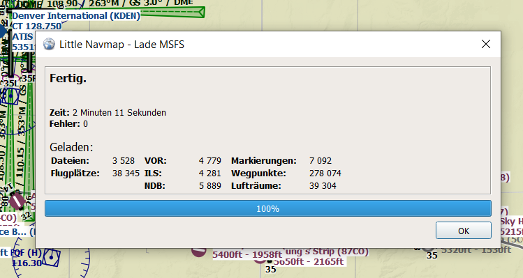

This is normal. The first dialog shows was what found and the other one what is left in the database after deduplication and other clean up.
The final number of airports, navaids and other objects shown in the
Load Scenery Librarydialog are lower than the counts shown in the progress dialog. After the data has been loaded, a separate process removes duplicates and deletes stock airports that were replaced by add-ons.
Alex
2 Likes
Does anybody know if the toolbar addon will be updated to work after the last update and hotfixes? I love LittleNavMap but fly in VR now so having the addon is a must with VR.
The addon still works, you just have to resize the window when it first loads to get the image to load.
It only works in 2D, not VR and the icon is blank.
Yes the icon is blank but that doesn’t stop it working - I’ll take your word about VR as I don’t run it - hopefully someone can pick it up and get it working fully with the new updates…
1 Like
Hi Alex,
I found that with the new Navigraph cycle 2109 for MSFS now a lot of VORs are displayed with an incorrect range, which makes pure VOR-VOR planning extremely difficult. Navigraph has updated VOR ranges to their ‘real world’ values (so far I experienced mostly reductions), but only in the MSFS data. Richard in the Navigraph forum noted that now we have to disable Navigraph data in LNM so that it pulls in the (Navigraph) data from MSFS, but the problem is that LNM still seems to just read the stock MSFS BGL files, so the VOR range info is now completely wrong. You can find details about the issue here: VOR ranges severely reduced in AIRAC 2109? - #9 by NAVData - General - Navigraph . Is it possible to fix this in LNM?
There’s also a secondary issue with switching off Navigraph data - all procedures are getting duplicated in LNM (screenshot also in that thread).
Thanks!
Dirk