Hi, when I make a plan in Little Navmap and then load it into FS2020, FS always adds an extra waypoint in the direction of the takeoff for a couple of miles, then directs me to the first waypoint I made in Navmap. So in FS that same waypoint is actually the 2nd waypoint.
It’s not a big deal, but in all tutorial videos I checked this doesn’t happen. I read the manual, googled but I just can’t figure out what is causing this. Anybody have an idea?
It seem to be an Asobo added default “Fly runway heading to approx 600ft - before turning on course”
Not that you should engage your AP that low, before passing 600ft !!!
FAA Order 8260.46, Departure Procedure (DP) Program, and FAA Order 8260.3, United States Standard for Terminal Instrument Procedures (TERPS), Volume 4, establishes guidelines for IFR departure turning procedures which assumes a climb to 400 feet above the departure end of runway (DER) elevation before a turn is made.
Ah, I installed Navmap today for the first time (and man what a great program it is) so apparently this added waypoint is a new feature/issue? One of the guides I checked was uploaded a week or 2 ago so I just couldn’t understand why I had this weird behaviour when loading a flightplan.
Maybe it’s not working correctly, as my plan showed an immediate 45 degree turn to a point 3 or 4 miles away. Also, it’s not a particularly useful feature for bush flying, in my opinion.
[Edit] I just remembered that there is a heliport on the runway heading so maybe that’s why there’s the 45 degree turn; however, 2020 doesn’t show any heliport at that location and it also doesn’t show in the satellite imagery.
It’s still not useful for bush flying! Actually, their whole VFR map is actually unhelpful for Bush flying. so I usually don’t turn it on at all.
Yes I noticed that, when I open the plan in an editor that extra waypoint is not there, MSFS adds it after loading it. And again it’s not a real issue, I just found it weird that I had this while i couldn’t find a single post from someone having the same happening
Well, I see it as well, (since SU6 I think) and thought it was quite an Acceptable addition, even if a little messed up VFR / IFR etc etc. And why 650ft ?? Interesting altitude to have picked !
Ok that is weird too. In the plans I made the added waypoint lead me a short while in the direction of the runway, which makes sense after N6722C’s explanation.
But it’s still very helpfull for bush flights I think? I made a route along roads, lakes, stuff like that, gave each waypoint a description (although I have to figure out how to make that description appear in the MSFS navlog btw), but it works great.
This has been happening to me and started right after the hotfix following the last world update. It doesn’t break the sim, but it would be really nice if this could be corrected in next sim update. This would make the sim perfect for me.
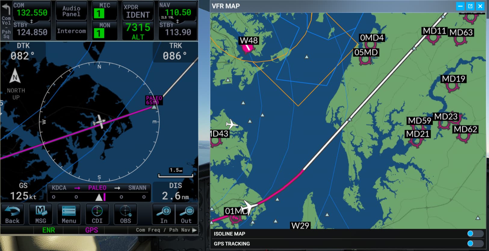
On a semi related subject, the Flight Plan as depicted in the MSFS “VFR MAP” seems not to be the same as that depicted in a GPS.
IT seems that Asobo has decided to add some “Curve Smoothing” to changes in leg heading, and seem to have matched that “smoothing of a turn” to match the higher speeds of Airlines, making it totally inappropriate for slower GA Planes.
In addition, the Magenta leg on the “VFR Map” often extends considerably past the leg’s end way-point, where it does not do so in the GPS display.
In the above screen shot, it can be seen that the “VFR MAP” magenta line curves and does not go through the way-point (Palleo) in an excessive way that would not be appropriate for slower flying GA planes, while the GPS magenta line goes to the the Wayoint, and is the actual path the plane will fly when on AP, using the FP in the GPS.
.
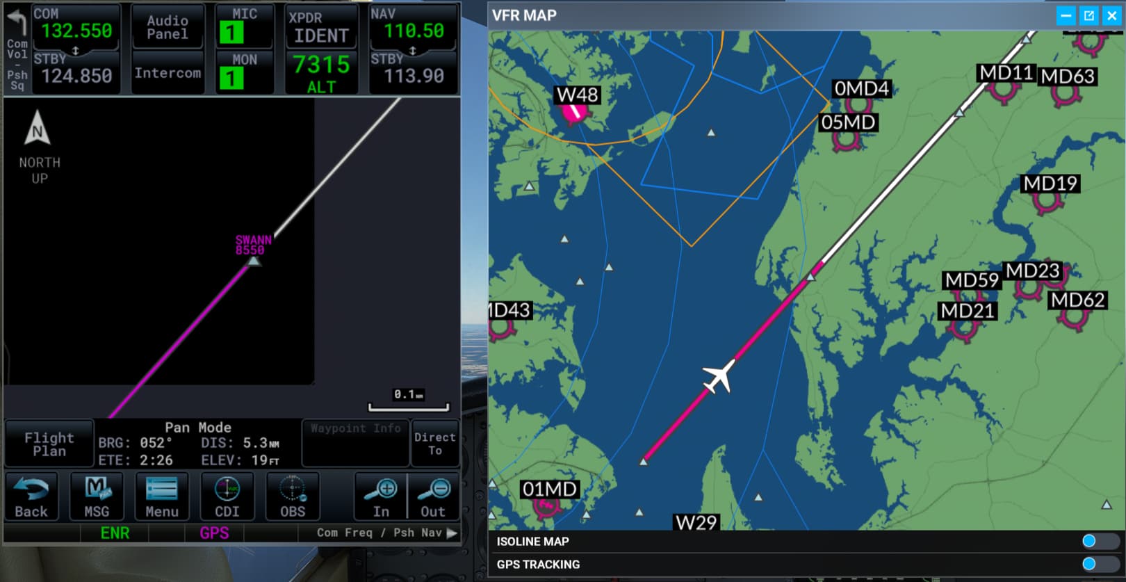
This the above screen shot, it can clearly be seen that in the VFR Map, the magenta line extends way past the end of leg way-point.
(Granted, this is more Cosmetic, and would seem to be a coding error in plotting the Magenta part of the Leg ? )
Do the CURVES really matter – probably not, as the “VFR MAP” is 100% a “MSFS SIM Feature” (like the World Map) , and not a realistic representation of anything similar in the real world.
 so I usually don’t turn it on at all.