So I just started using this software, which seems really nice. I made a flightplan, exported it for MSFS, loaded it, started flying it. All the waypoints were correct, but the flight didn’t follow the exact plan. Especially one waypoint was way off.
Here’s the specific problem:
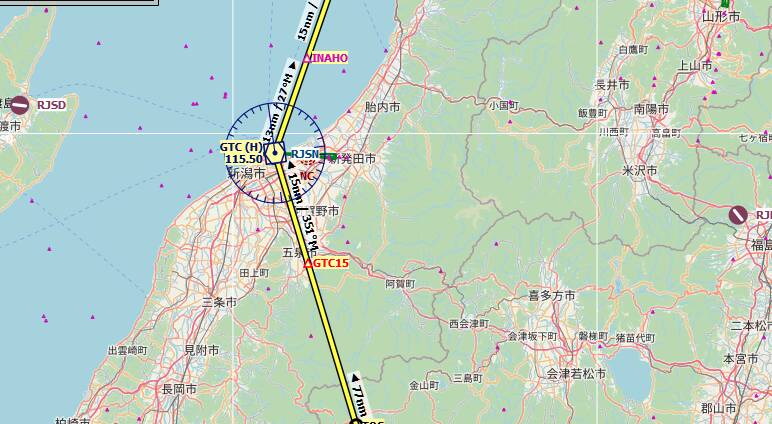
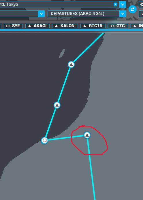
GTC15 is placed in the MS filghtplan differently than in Little Navmap.
The red circle (well… more of an ellipse  ) is GTC15 according to MSFS.
All the other waypoints seemed correct and the naming of all of them was also correct in the Airbus flightplan.
Is this a known problem or am I somehow using the wrong underlying data? I did import everything from MSFS and started with Little Navmap after the most recent sim update (no previous data). So this was a bit of a surprise. I was hoping to finally get around that dodgy flight planning of MSFS, but seem to have landed in different problems.
EDIT: So, remarkably, after reloading the flightplan in Little Navmap I now see this warning…
And it indicates GTC15 doesn’t exist.
Not sure why that only now showed up. And it’s still a bit weird, cause I didn’t invent that waypoint in the flight plan and MSFS seems to know it anyway, all be it in a different spot. I do remember turning off some other data sources, so maybe that had an impact later on (initially loading the waypoint from another source than MSFS).
Okay, well, progress…?
Did you update/import the scenery library in LNM to represent the latest state of MSFS?
Did you create the flight plan in LNM and when loading it back in, the way point is marked to be unknown? That would be weird.
Yes.
But I’m playing around with it now and starting to understand. Initially under ‘Scenery Library’ the Navigraph was switched on as source. When I turn that off, GTC15 becomes an error (as do the departure procedures).
So it’s indeed getting data from sources that do not match with the MSFS stuff (I think).
You need to use MSFS scenery library only (and update it whenever MSFS gets an update or you install a new airport addon), then you should have a matching database.
Yes. I know. That was all imported. But apparently there’s more sources you can turn on and off and I now guess they should be off.
Sadly I then lose all the departure procedures too.
Coppersens, the pic appears to have Chinese (Taiwanese?) Does, LNM cover those countries very well? Never tried a Flight Plan there…
Lord, don’t let my wife find out about this, she’s from Tokyo and expects me to know a little about the language 
2 Likes
Scratch my comment, EmemPilot just educated me, MSFS and LNM have Japan pretty well covered…
Sure. The simple reason is standardization and it’s the basis of how aviation is able to work worldwide
I think there’s a big overlap in characters, so I’d say you’re safe 
I don’t think it’s Kanji on the map, is it? Well, dunno… it might be… See, I’m no expert either
I won’t tell her.
1 Like
I really think it’s the Scenery Library setting. I lose all the goodies if I turn off Navigraph. But then at least I’m not bothered by that GTC15 anymore. I think that data-mix between MSFS and Navigraph is causing my problems. I do remember the departure procedure also not working very well.
LOL, I’d ask her but that’d give away my ignorance! The beauty of the simulator world. I’ll hop over there later and see if I can duplicate that leg of your Flight Plan…
1 Like
Ah see here… I solved my own problem by rambling about it…
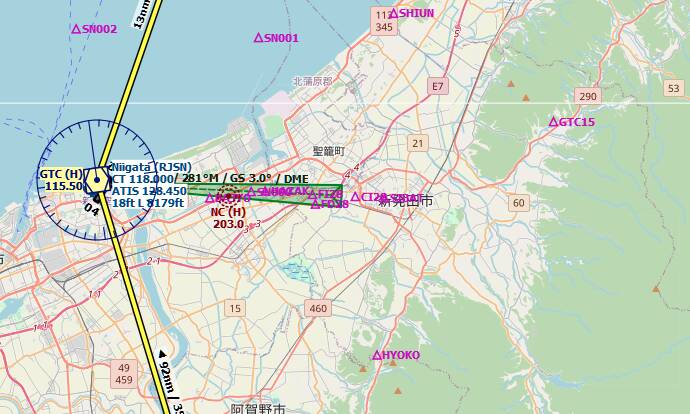
There’s GTC15 now (on the right), where MSFS places it in its own flightplan. Now at least the image matches the MSFS data.
2 Likes
Still, after this waypoint adventure, the question lingers: why is there so much conflict between sources? I thought MSFS got its data from reputable sources? Import bugs or can a waypoint really shift like that in updates?
If I were a real pilot I might consider staying away from all this sim business. It’s confusing.
1 Like
If you have Navigraph installed as an Addon and replacing NavBlue, then LNM should display Navigraph for maximum utility.
I would raise the issue of the waypoint on the Navigraph forums and see what Richard says. They do an excellent job of isolating if it’s their data, or something in the sim.
It’s usually something in the sim, like the way the Flight Planning logic works. Unfortunately that’s what WT is trying to fix - they need to embed the correct Flight Planning logic into each Nav Unit to override the core sim logic (prototyped in the CJ4, coming soon to G1000 NXi) but they also eventually have to fix the Flight Planner in the sim itself. Not a trivial task by any stretch.
No, I don’t have any Navigraph thingies installed. But with LNM comes a Navigraph cycle (1801?). And that’s default switched on. That’s why I had all these nice procedures showing up. Approaches, departures (that didn’t work properly) etc. and mismatching waypoints.
Only if I turn off Navigraph it matches with MSFS.
1 Like
So that’s part of the problem. If you want 1:1 correspondence (as best possible) for LNM and the sim, you need to load the sim scenery into LNM. It’s a four minute exercise, but then it’s WYSIWYG. The only deviation will be when the Flight Planner logic kicks in and overrides a procedure leg that it currently doesn’t understand with a haphazard use of USR waypoints. I have another thread currently underway about that.
And if you want all thos neat IAPs that NavBlue doesn’t have, I strongly recommend the cheapest annual plan with Navigraph - about 37 USD. That gets you access to the NavData (no charts) but it will override NavBlue, and by extension, appear in LNM if properly configured. Until SU4 update last week, the US alone had so many missing IAPs compared to Navigraph. That gap has now closed, but for global regions, Navigraph is still hands down better.
Dumb sick guy here, sorry.
So LNM CANNOT have the same exact waypoints as Navigraph so the data sets do NOT match 100%, of 100% of the time?
Kind of defeats the purpose of using the new Navigraph window that has charts and the flight plan on it.
Sick, dazed and confused, here. Once again, sorry.
FYI: The Chinese airports issue: I did have a mountain that did not show up on the standard LNM global data. Alex had me download the Global Data library from a different location and I installed it. The Chinese Mountain appeared.