Disappointing flight tonight. 4 hour flight to PANC for the bad weather, only to find the sim created a perfect circle around the field of mostly clear skies. Not a snow flake in sight. Visibility was poor until minimums and then it cleared up and looked like a friggin hurricane eye. Hate it when the weather logic does that. Really hope we can continue to see a better job of blending meteoblue with metar data

5 Likes
It shows how ridiculously bad the sim is with vertically thick clouds like nimbostratus, altostratus etc. Ever since SU7 it went to hell.
METAR LKMT 120730Z 22009KT 1800 -SN BR SCT011 BKN013 OVC049 M04/M05 Q1005 NOSIG=
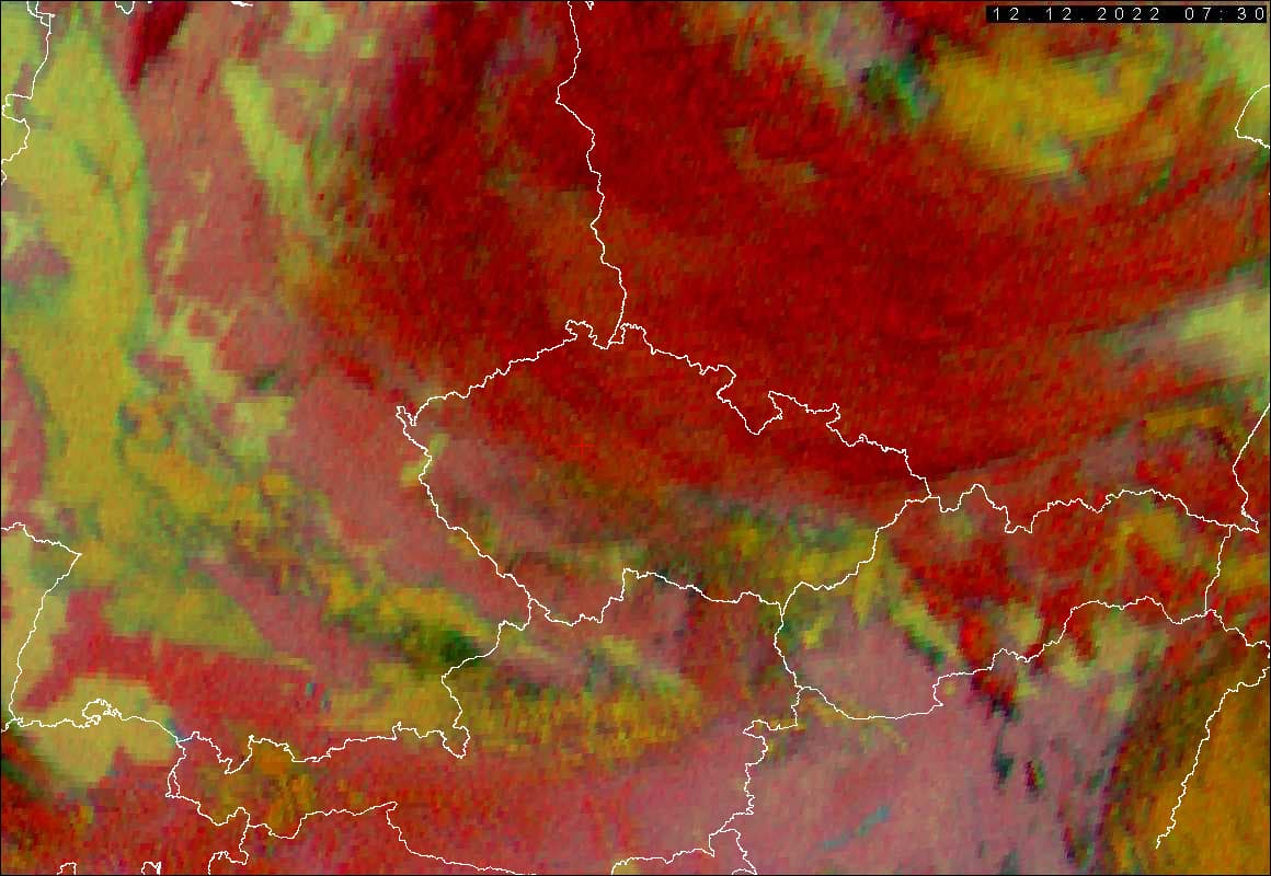
((c) 2007-2019 ČHMÚ & EUMETSAT (http://portal.chmi.cz/files/portal/docs/meteo/sat/info)
borders: (c) ArcČR, ARCDATA PRAHA, ZÚ, ČSÚ, 2016.)

Sim screenshot taken near the center of the satellite imagery image below the reddish upper-level cirriform deck.
4 Likes
Yes this is besides taking away the cloud density - one of the large faults since SU7 - absolutely no continuous cloud expansion upwards (is an eternal problem of METAR based engines anyway). The weather may be correct “from below” at the airport - but that’s about it.
That was before SU6 (say that intentionally so) - already quite different !
2 Likes
Because we do not have same weather model anymore. Thats why. They changed to another more frequent updated weather model with post processing. I think they also changed rendering of clouds to match that new type of weather model. Maybe a bit more accurate, but much less realistic behaviour. I’ve lost hope that we ever will get that weather model back again.
I expect some improvments in the next updates. But the potential has decreased much in my opinion. Only things we will se will be improvments of blending. Blending to me means a mess. Either we have it dynamic or static/fixed. Those things are completely different things. Can’t blend static and dynamic. Can’t find a word for that. It’s only in a flightsim that exists and it’s called static/dynamic hybrid or something.
Unkonown weather are able to change= dynamic
Known already reported weather is fixed and can’t change= static
2 Likes
Interesting observation, have seen a few streams from users in Europe and they seem to have had a much better and convincing levels of depictions that what I have been getting here in the US. I know weather can be somewhat specific to a certain area but when flying in the US, I feel like I have run the gamut of all the levels of depictions and am seeing less variance. Anyone else feel or notice this?
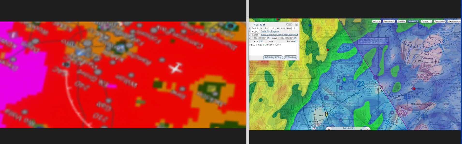
I was messing around on Saturday morning during the big storm that was affecting the Central Valley of CA. During this, I took a screenshot that seems to show a little of the blending that’s going on. On the left is the MFD from the G3000 with NEXRAD, rotated and scaled to approximately match the real-world radar depiction from SkyVector, as shown on the right.
First, I’m glad to see the generally more intense area to the west correctly located, but I feel the values they’re using (meteoblue?) are somewhat ham-fisted and over-gained compared to the actual NEXRAD resolution. I don’t understand why they can’t just pipe the latter in.
In a significant part of the US, Canada, and the Caribbean, the WSR-88D data correctly show precipitation at any given time. I believe the weather radars across Europe, Australia, Japan, and South Korea do as well (let me know if there are others). Granted, those data are slightly delayed and there are intervals for radar volume scans, but it’s a lot more granular and timely than surface observations imposed on whatever the larger dataset is that’s being used.
The hardest part is at the edge of the radar range or in mountainous areas where the scan doesn’t reach close to the ground.
Wish: If nothing else, I’d like to see that big blob of red have a lot more nuance and attenuation of the depicted precip and more focus on the variability/gradient within the areas of more intense echoes to match reality. Gain it down so green matches green, etc.
Second, where some of the airports with ASOS/AWOS (METARS) are not reporting rain (or less intense rain, it looks like it puts a little bubble of less precip around the airport (see KMHR and KJAQ in the depiction). Again, kind of ham-fisted. But I believe that’s the “blend” we’re all talking about.
“It’s close enough for jazz” goes the axiom, but if better, more granular data are available, why not use them?
1 Like
My assumption would be that those granular values are either incompatible or would alter the METAR variables. METARS work with clearly defined values, cloud type/levels, wind direction, visibility, they can’t use constantly changing variables that in depth data would provide.
Perhaps they should use the NEXRAD data for precip and just use METAR for wind, temp, and pressure? In the real world, unless the precip (or other) hits the values to warrant issuance of a SPECI, brief rain showers might not be noted anyway.
Thats what we had pre su7. At release nothing from METAR. The improvments since release in weather has been more and more things from METAR. Nothing for us that hoped to see more data from Meteoblue that already fits the weather model. Instead we have several sources of weather that disturbs.
2 Likes
I find that for snow depictions the in house live weather does a much worse depiction then for rain…If a metar is reporting rain for me the weather is usually much closer to real…but when there is snow (especially light snow) the sim doesn’t render any snow and the clouds are much farther off.
1 Like
I would agree on the cloud depictions being wrong again. OVC005 is like 2000ft AGL. The stratus layers are non existent now. It’s not bugged by METAR reports as it was working correctly at one point after SU7. This campaign against aviation weather is ridiculous. Once again though, the weather is broken. The wind is pretty much perfect. Visibility and precip is working. Precip is not always on radar IRL, especially with light precip. Cloud cover is broken. Stratus layers are incorrect.
1 Like
Once again, changes to weather will most likely be happening around mid-January (possibly) or with SU12. Asobo will reach out to MB to talk about third party access to the weather API in January. A turbulence scaling API has already been confirmed at the minimum.
1 Like
If a model can’t predict that there is no snow when in iSA conditions at sea level, I would say the problem goes deeper than low resolution map for snow… It is just flawed.
1 Like
I’d like to add that having the “metar bubble” system since SU7 doesn’t guarantee that the weather is correct, at least in airports. I’ve seen multiple times sitting on the ground in airports, weather completely different from what was reported in the Metar.
There are huge limitations even with this system.
1 Like
-
How can they plot that using METAR?
Have you ever heard of interpolation? -
I bet they do. But name one that doesn’t expect the weather to change in the meantime they fly that planed route. You mean because they have checked those reports the weather is then static and not able to change?
That is exactly what I said, they check sources and plan their navigation accounting for weather changes. Just go on and talk to some real pilots, it is good learning of how they plan and how they also consider possible alternate in case the weather goes crazy beyond predictions.
Have you ever had ActiveSky? They provide a lot more than just METAR depiction, there are ways to work with METAR and other weather observations. I am not here asking to have only METAR in the sim, that is flawed. But if you have a few years of experience with flightsims, you should know that there are other ways to work this out. The way it is now, and was before, does not work.
1 Like
Exactly! Even with the METAR bubble right now it does not match the real world. And I don’t know if they have anything against Belfast or even the whole island of Ireland, but the weather depiction around here is off. I mean, I have windows in my house, the sky is clear and it plots rain. It is raining, and it plots sky clear. Meteoblue shows what I see from my house, MSFS does not.
I am not asking for perfect real world weather as I see from my window, but something that matches, resembles, real world data. I am tired of loading on the sim for a beautiful VFR flight in Northern Ireland in a nice weather day, just to be thrown off by a horrible weather depicted in the sim. Then I go to x-plane and fly happily (just without the great visuals).
5 Likes
You should try Los Angeles or San Francisco, the sky that the sims gives you there it’s absolute nonsensical apocalypse of broken dark CBs… same as Taiwan…there is definitely arras that are worse than others…but at this point the weather has too many issues and Asobo keeps ignoring us/them and keeps on adding and adding without fixing long standing issues.
5 Likes
I have and i have also seen both after su7 in this sim and also in other simulators. I have also used Active sky. And that has tons of options to be able to make it behave more realistic like tune the hard transitions.
But no other simulator have ever had more dynamic and fluid weather as this had at release with only Meteoblue in use. It didn’t need interpolation. It were forming over time as weather does. Real weather doesn’t need interpolation either.
11 Likes
Yup. ActiveSky had their weather map which was very handy. All the way back to ASN. You go wind the clock forward and see the predicted weather. Even if they decided to use TAF’s instead of METAR the weather would be more dynamic as it has a data set that isn’t just one string. Guarantee the pre SU7 weather would come back if that was the case. It’d be more in line with MB’s model.
I live near SF and the last few days have been the same both in sim and outside, happened to do some Norcal flying there. Try again.