Switch to XP12. Their weather system is amazing. There are all clouds, including cirrus clouds and Cbs (which have severe turbulence). I’ve uninstalled FS and I’m not coming back any time soon - unless Asobo decides to actually do something about their weather system.
XP will soon also get a new weather radar. Where you can change the tilt, gain, switch between WX or WX+T, it’ll have predictive wind shear, will show echoes that bounce off of other planes etc.
The weather system in XP can be slightly inaccurate sometimes, but it’s a good tradeoff. It looks and feels amazing.
6 Likes
You are absolutely right, I have been hesitant for over 2 months. I am using Active Sky, which greatly improves the weather. However, I am disappointed with the constant bugs and bugs and bugs, and the constant excuses from Asobo. The weather has had problems for a long time and it is being ignored. I am seriously considering going back to X-Plane just because of the thunderstorms that no longer exist in MSFS.
4 Likes
I think that the weather bug has been fixed, in MS eyes, by introducing the cloud pixels to control the amount of cloud coverage to match the static METAR history (as per user feedback, sadly) and be “similar” to the geostationary satellite’s picture outside the airport areas. This is easy to spot over the Pacific Ocean, filled with white circular spots around the islands. It is very difficult to represent any dynamical weather features, like evolving thunderstorms, on such a weather platform.
1 Like
but its not difficult to show thunderstorms over an airport when its stated in the metar… and i have no idea how its work but, take ventusky, windy or other weather websites… how are they able to display flashes in realtime … also in realtime over oceans thounds of km away from any metar station ?.. for my understanding it should be simple to transfer these informations by a dedicated weather partner like meteoblue is .. btw windy.com is meteoblue.
1 Like
Real-time flashes in weather apps do not come from observations. They come from a worldwide commercial lightning detection network called NLDN which uses an array of sensors spread over a wide geographical area that detect the low frequency radio emissions (called “sferics”) generated by lightning strikes. The exact location of individual strikes is done by triangulation between multiple sensors.
Unfortunately NLDN data is quite expensive. Weather apps like “Weather Bug” can afford it because they are supported by subscriptions or by advertising revenue. The cost that MS/Asobo would have to pay to use NLDN lightning data in MSFS would probably be far too high to be justified. There would be no way to recoup the costs.
There is an alternate lightning detection network called Blitzortung that is free. It is a crowd-sourced network where hundreds of people around the world host lightning detectors at their homes or businesses and feed the data to Blutzortung servers using their local Internet connection. It is a “labor of love” for those who participate, because detectors have to be purchased out of pocket as well as the cost of the internet connection. Most of the people who host Blitzortung detectors are “weather geeks”, or ham radio operators or others with a technical background or interest. Whether MS could (or would) use Blitzortung data in MSFS is debatable. Blitzortung has restrictions on using their lightning data for commercial purposes.
The NOAA GOES 19 geostationary weather satellite also has near real-time lightning detection which is based on detecting the visible flashes that lightning produces. That data can be freely used by anyone, but the coverage area is limited to mainly North America.
5 Likes
Flew a 5 1/2 hour flight in the Hot Start Challenger 650 a few days ago. It still needs a ton of work. Cloud depecition looks terrible at times.
The age-old axiom applies:
You want accuracy, coverage, and cheap - pick two.
I know … Speculation: a thunderstorm shall not appear suddenly when METAR reports it, and thus the weather has been made “looking less wrong” without thunderstorms, than with suddenly appearing thunderstorms. In the first year of FS2020 the weather actually had its own natural cycle and the features, including thunderstorms, had time to develop naturally.
Yep, what do you do when the METAR says clear and the next one says thunderstorm in vicinity. That storm just can’t pop out of nothing. It’s not an easy problem to solve, although I think Asobo could do a better job with this.
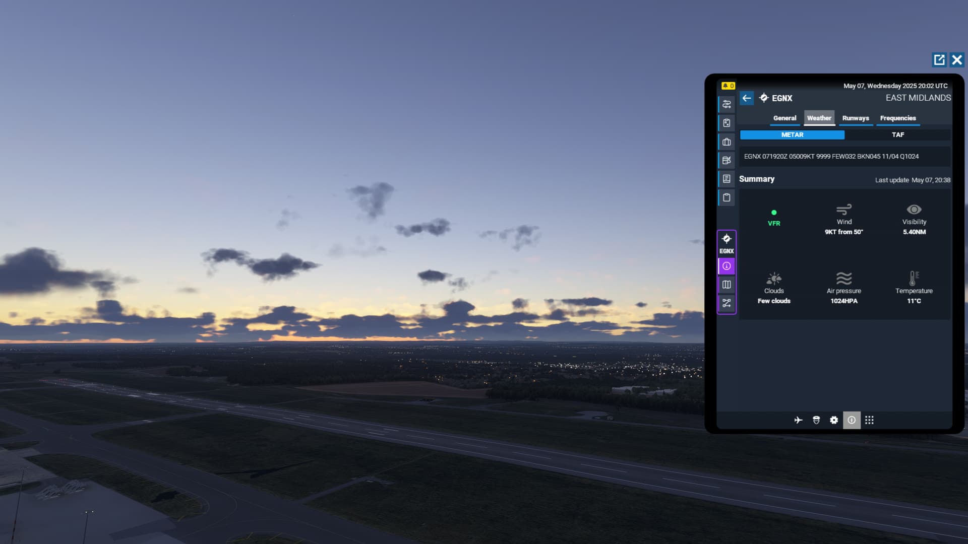
METARs are not great sources for making realistic weather depictions. I’m getting ready to fly for real here, and these are the current sky conditions:
Most recent METARs:

The METAR doesn’t report clouds above 10,000 feet, or lower clouds if they’re not right over the airport, or visibilities greater than 10 miles. Lots and lots limitations that make them problematic for recreating realistic weather depicitions.
4 Likes
Agreed! The weather system cannot be based solely on METAR data for exactly this reason. Will Asobo show that they care, or will they continue their extended radio silence?!
1 Like
I’m playing on the most recent (12.2.0.4) beta and the clouds are absolutely amazing. At least as good as clouds in the very first iterations of MSFS, before they started blending the data. Usually they look 10x better though.
1 Like
Same…
![]()
I have Active Sky for both sims and generally use them instead of what is supplied with the sim.
1 Like
EDIT: Disregard. Misread your post.
Interesting. SPI is towered and are doing manual/augmented observations, so they shouldn’t be limited to the 12,000’ of a strictly-automated station.
It’s not based solely on METAR. METAR augments other sources, otherwise we’d have zero weather in between. The problem is these sources can be disparate, revealing inconsistencies when the others are lagging or missing information, often due to geographical or temporal constraints. That, or whatever other processing is or isn’t happening under the hood to fill in the gaps.
1 Like
Okay, then I misunderstood. Exactly what did Asobo do in SU5? They claimed a new METAR-based weather-injection system, didn’t they? So how much is METAR based, and how much is still using the old system?
1 Like
We don’t know the ratio, but I can unequivocally say that the system is not entirely METAR-based. If it were, you’d never have any weather between stations, and/or all weather would only be big blobs radial to stations. It’s clearly not, however we do see that there is augmentation in the form of the blobby “METAR bubbles,” formed, once again, when the two (or more) sources don’t spatiotemporally agree.
In terms of what’s communicated, when, and the source of the past and current in-sim weather realities, we don’t really know the details because nobody in the know has been willing or able to clearly elucidate what’s going on. But I think there’s a lot of assumptions being made as to the “METAR-based injection system,” as if that’s the entirety of it. The word “injection” could be viewed in several ways, but again, nobody really speaks to it and that was several years ago, anyway.
If you want to see what the large-scale in-sim weather is doing, activate the weather layers on the free-flight or mission map. It’s a lot more dynamic than you’re giving credit, but still not good enough for some more ephemeral phenomena.
2 Likes
Roger that! However, while it may have worked previously, Live Weather is certainly not working the way it is supposed to be anymore. I hope this will be fixed.
2 Likes
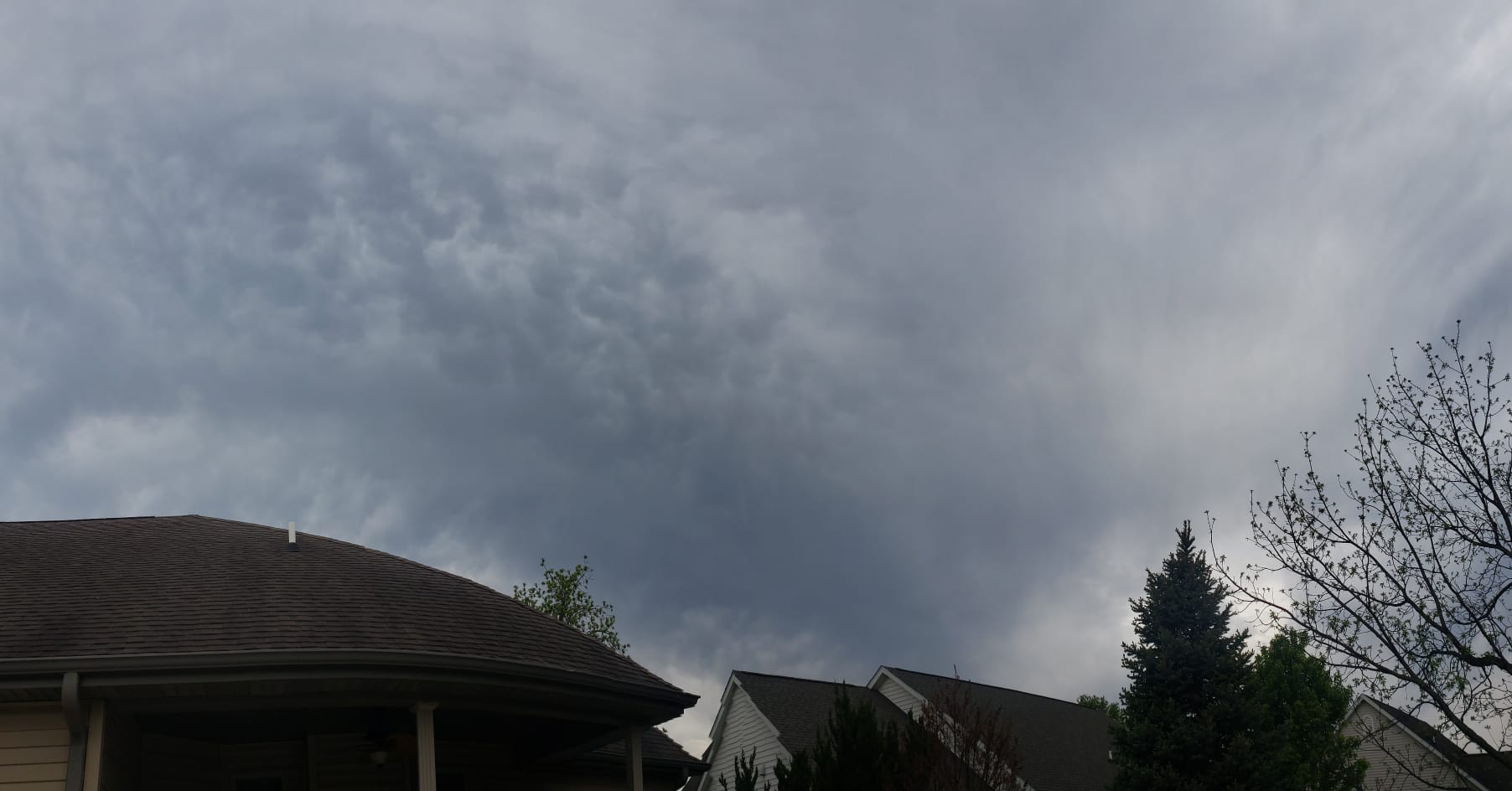
I just cannot understand why Asobo are not on top of this bug. If they believe that this is 2 cloud layers few at 3200 and broken at 4500 they are seriously deluded.
Live weather does not match. Doesn’t match real life what we see out of our window, does not match what the world map shows. Does not even match what the metar says in the sim itself.
All these years after this bug report was filed and we have heard NOTHING. Zero. Zilch from Asobo.
14 Likes
I wish they would ditch the meteoblue partnership and join forces with ActiveSky
5 Likes