Ive got myself down a deep rabbit hole with Aircraft Altitudes.
Bottom line - Does LNM display the Planes TRUE physical altitude above sea level, or the plane’s Indicated Altitude ?
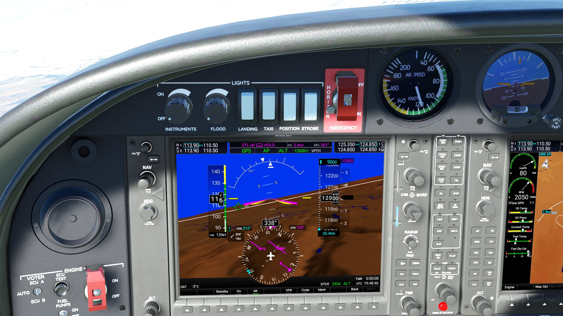
I had Assumed as a GPS type system, it was displaying TRUE Height above sea level which would not change with Altimeter setting or non Std Pressure – but it seems that LNM is displaying what my Altimeter reads, and if I mis-adjust it, then the LNM altitude changes as well.
That is fine, if that’s what it is designed to display – but in seeing this, it also now seems that an Addon like the Enhansed VFR Map is also displaying an unexpected AMSL & AGL value, which is varying with the Altimeter setting, so is only displaying the TRUE AMSL Height, at Std Pressure.
1st, thanks for taking the time to produce those two screen shots …
Yes, as you have your in-cockpit altimeter set correcyly.
My point is, that LNM is displaying your planes Indicated altitude, as displayed on your altimeter, and not necessarily the TRUE Altitude (Height) of the plane above MSL.
Its almost a if it is displaying the Instruments in your plane, as opposed to what the plane is really doing in the world, wrt Altitude.
As I said, that’s fine if that’s what LNM is designed to do … but i did not expect the Enhansed VFR Map to effective be displaying your Flight Level and calling it AMSL
If I use real weather, and note the baro setting, and then go and use a Clear sky weather profile, and set baro to the same as the real weather was, (Pressing B each time) I get different results. If is almost as if Real Weather may not be setting all the baros when I press B ? - or something … its Certainly is “Different”
Will require a little Investigation, and monitoring some sim connect variables to figure out exactly what is going on … maybe Real Weather is even more messed up than expected.
I also have Rex, so that’s a 3rd option to set Baros, and see what happens.
There is really no such thing as “true AMSL” in aviation. If you have the correct altimeter setting for your location, you will get a pretty good indication of what might be “true AMSL”. All of the related instruments, the autopilot, cabin pressure etc. will indicate and react on that basis, so if you change the altimeter setting the altimeter will show a change as well and, if you are on autopilot, it will climb or descend to get you back to the value you have set.
Above transition altitude (18,000ft in NA), everyone is on 29.92 and stays there as long as they are in the block airspace. So what happens as you fly along at a constant indicated altitude, the airplane will gradually climb or descend slightly as the barometric pressure changes. This doesn’t matter for the most part since everybody up there has the same altimeter setting.
LNM correctly displays the same info you have in front of you in the cockpit.
Hope this has helped you at least partly out of the rabbit hole!
Thanks @wilco3563 for that reply and confirmation.
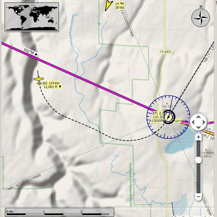
The main situation I am trying to get my head around, is why with a Weather Profile, the calibrated Altitude (Indicated Altitude) always matches the GPS Height of the plane above sea level (irrespective of temperature, humidity etc), while with Real Weather, the two can vary so much.(as it should)
I believe I understand the concept that below 18,000ft, when planes are set to local Altimeter settings, their Indicated Altitude will only match the GPS Height at current Ground level (or more precisely, the Ground level of the Airport issuing the Altimeter setting), and as the planes flies higher (Or lower), they Indicated Altitude can differ from the GPS Height — but that applies to all Planes in the area below 18,000ft so all planes that have in Given Indicated Altitude are at the same Height above MSL or ground level, which is key for separation etc - absolute exact Height only becoming a major concern near ground level.
But the above (at least to me) does not explain the difference between what happens when flying in the Sim, with a Fixed Weather Profile, as opposed to flying with real weather.
My gut feeling is that the Fixed Weather Profile is what is unrealistic, in the way it calculates the pressure occurring at varying altitudes, as it may not be talking temperature into account, and defiantly not Humidity, whereas the MeteoBlue weather, which has both these parameters simulated, is including them in the current Height’s Pressure calculation.
This may also be tied up in the issues on MP networks like Vatsim & IVAO, where XP11, FSX, and P3D are not using the MeteoBlue weather that MSFS has available.
By GPS height I mean The TRUE real World Height above MSL,(as an absolute reference) as opposed to an ALTITUDE obtained by using air pressure to derive an approximate distance above MSL.
I realize that almost all aviation is based on Altitudes derived from Pressure Transducers, although there are some exception, like Radio Altimeters, for shorter distances.
My Dilemma is not that the ALTIMETER does not read the TRUE real world height, when using Real weather, (which is realistic - temperature, Humidity etc affect things) but that it does when using a weather profile – which probably implies that when using the currently coded MSFS weather profiles, temperature & humidity are ignored (as an approximation) or because they are just not available for a Simulated profile.
I don’t think a lot of people, and even some pilots realize, that when they are flying at 4000ft indicated with their Altimeter set to the local Altimeter setting, they well may not be at 4000ft ASL, but then, anyone else near them doing the same, and thinking they are at 4000ft, are also at the same altitude, so its all relative (within reason !)