MCDU loading wrong runway STAR ILS23R KPHL

:wave: Thank you for using the Bug section, using templates provided will greatly help the team reproducing the issue and ease the process of fixing it.

Are you using Developer Mode or made changes in it?

No

Have you disabled/removed all your mods and addons?

No

Brief description of the issue:

Default A320 MCDU loads the wrong approach procedure for the selected runway.

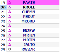
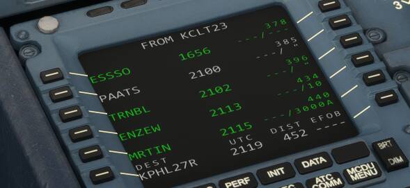
Provide Screenshot(s)/video(s) of the issue encountered:

image
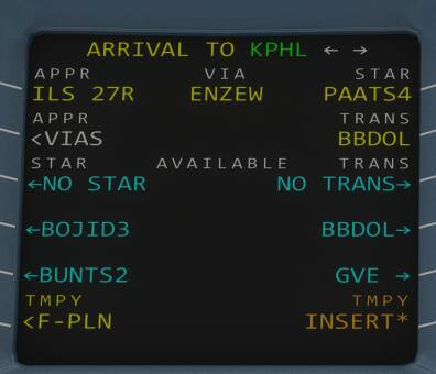
Correct procedure for ILS27R at KPHL via PAATS STAR
image
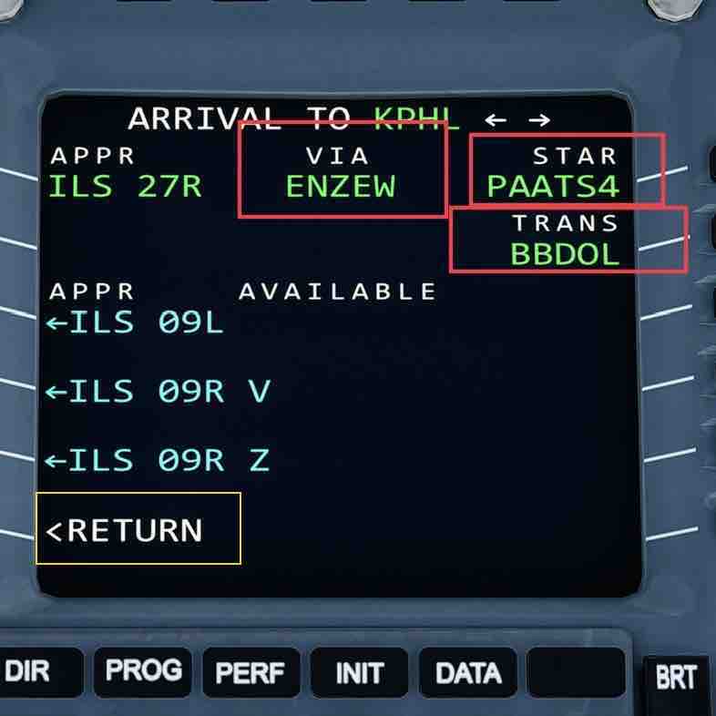
What the MCDU loads for ILS27R at KPHL. This is the procedure for 9L/9R.

Detailed steps to reproduce the issue encountered:

Fly a STAR without using the map flight planner and this will probably happen. This also happened when I tried to fly to KBOS. Flying the ROBUC3 approach to runway 27, it instead attempted to fly me on a procedure for a runway on the western side. I imagine this happens on any STAR and is extremely gamebreaking.

PC specs and/or peripheral set up if relevant:

Build Version # when you first started experiencing this issue:

Latest


:loudspeaker: For anyone who wants to contribute on this issue, Click on the button below to use this template:

Do you have the same issue if you follow the OPā€™s steps to reproduce it?

Provide extra information to complete the original description of the issue:

If relevant, provide additional screenshots/video:

Do you have navigraph navdata installed?

No. After googling apparently this is a bug that has been around since launch in Asoboā€™s FMCs. FBW fixed it after some time in theirs but I donā€™t care to install it. Guess Iā€™ll just wait for AAU3, or 4, or whenever.

Iā€™m not sure why the map flight planner isnā€™t being used. Using the A320neo and the World Map flight planner, the waypoints for the STAR PAATS4 and the ILS 27R approach load correctly into the MCDU.

Initially there were World Map issues with SIDS and STARS but they were fixed several updates ago but probably not well documented in any Release Notes.

FWIW I tried entering a flight plan manually without using the World Map flight planner. It duplicated the same error you described (the wrong waypoints for the STAR). However, I discovered that part of the STAR entry was missing. When I manually entered the transition waypoint BBDOL for the STAR and the VIA (IAF) ENZEW for the ILS 27R approach, the correct waypoints for the STAR were populated correctly into the MCDU. That is, when the approach was entered correctly, the waypoints were correct in the MCDU.

1 Like

Simple- I want to learn to use the computer.

Can you give me a step by step of what you mean/did? I am trying to replicate this so I know how to do it right.

No matter how I enter the STAR it always wants to put me to TRNBLā€¦ am I supposed to enter the waypoints that diverge from PAATS on the chart manually?

image

I donā€™t get it :frowning:

Here is my screen:

Notice anything different from your screen?

1 Like

image
image
Iā€™m absolutely clueless as to what Iā€™m doing wrong

I donā€™t knowā€¦ very strangeā€¦ The only thing I can think of is an add-on of some sort. Do you have or ever had the Navigraph add-on?

Iā€™ll send you the flight plan created by the World Map planner. It SHOULD populate everything correctly.

The original problem that was fixed a few updates ago was that the World Map flight planner wasnā€™t reading SID and STAR information correctly. Looking at the PLAATS FOUR ARRIVAL, there are 4 or 5 ā€œexitsā€. The original bug was that the flight planner always took the first ā€œexitā€ no matter what. Now it recognizes the correct ā€œexitā€ for the runway/approach, even using manual entry for the MCDU.

1 Like

Nope, no navdata addons whatsoever. I suppose I will manually enter the exit waypoints from the transition to the VIA before my departures until this gets changed but at least the transitions work-- I never had a problem between BBDOL and PAATS, for example.

The interesting bit I just noticed is that TRNBL is a waypoint on an exit but isnā€™t an exit itself. If it were going to 9L/9R, itā€™d go to TRNBL then WEEVE then ERNEY which my MCDU doesnā€™t actually do. It seems like the ā€˜defaultā€™ point that would next lead to the airport, like if you look at the STAR on SkyVector. Very strange indeed :frowning:

Here is my flight plan created by the World Map flight planner, This has the correct STAR and approach waypoints. This should work correctly in your MCDU. In addition, the flight plan has all the waypoint altitude and speed crossing restrictions.
ifr_kclt_kphl_27r.PLN (11.8 KB)

For me personally, I use flight plans created using the World Map most of the time even though I have a Navigraph subscription. I will occasionally use SimBrief or LNM but they both have too many features I donā€™t use. In addition, their flight plans leave out important information like waypoint restrictions.

Let me know if this flight plan works for you.

1 Like