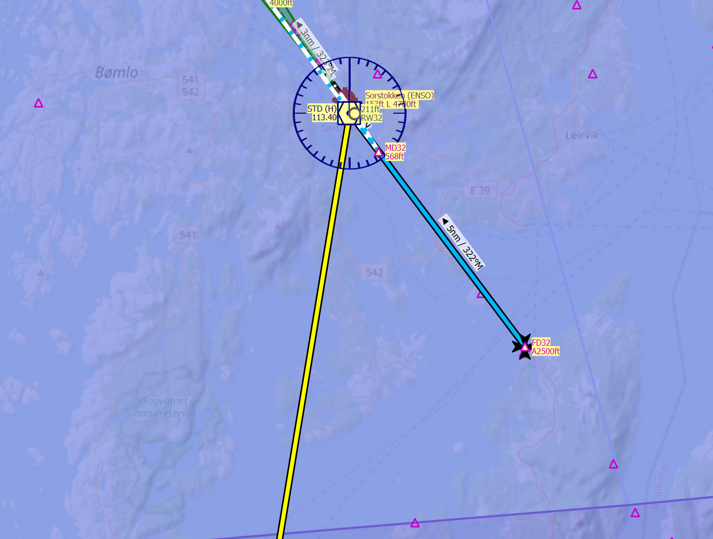
Newb here. I’ve been playing around using littlenavmap and have successfully done flight plans involving VOR navigation. At one of the airports I pulled up the VOR/DME procedure for the destination airport (using littlenavmap which is awesome) and it showed as in the below image.
Question is what does the waypoint FD32 mean? Seems like I should be at 2500ft at that waypoint but I don’t really know how to navigate to it (without cheating using the flight following on Littlenavmap) using only VOR. I was tracking STD VOR inbound. I’m probably missing something basic here.
If you have the approach chart of the procedure you want to follow, all the information for navigating is there. I am not familiar with Littlenavmap, but from the picture you posted, there is no way to navigate as it is incomplete. FD32 is the final approach point for an approach to rwy 32. If you are flying a VOR32 procedure and you have the chart for that, you will see that you have to fly the radial 129 (or 120 depends on your aircraft type) outbound for 8 miles and then make a right turn to intercept the radial 141 (course 321 inbound), you do that while descending from 4000 ft downt to 2500 ft, and you start your final descent after passing waypoint FD32 which is at 6 dme, but you need an approach chart to read all that… I dont think Littlenavmap has that…
the best one is navigraph, however as you said that is a paid subscription, well worth it.
But free sites there is skyvector.com which is great for enroute charts all over the planet, however it has SID, STARs and approach plates ONLY for USA, so if you want to fly in USA that site is excellent and free and has everything you need, outside USA I don’t really know a free site specially for approach charts.
Skyvector may not help much with that one, that’s Norway. That’s a terminal intersection, so what it appear to me is since your last plotted waypoint is to that vor located at the airport, it’s trying to tell you if you are using that vor to navigate and land at the airport, that you need to align on a 332 to the vor at 5 miles out at 2500 feet to line up for the runway. And the next one is MD32 for landing.
Wrt to that way point, and if u have a previous reference you should be able to dial in the 322 inbound radial on that vor and fly until u intersect it.
That should put u close to the wpt.
I can’t see the previous vor but for redundancy I would dial that one into the radial that intersects the 322 radial of the first VOR a few miles before the wpt and keep tracking that too
In theory u could also fly the direct inbound track and 5nm before, start a 90deg right turn dialing in 322 inbound and then track dme to stay 5nm from it while adjusting further left until u intersect basically flying a long arc
(Edit 2: I have no real experience on this irl thats just guesses from playing sims, pilots please chime in i would be interested too)
Also, intersections are used for a lot of different purposes. You will primarily be concerned with the ones tied near vor’s when you are doing “manual” flying to a destination using navaids instead of the various nav systems (which is fun). They help keep you on “airways” or “victors” to the next VOR off of the one you just passed, because many times you will pass over a vor, and you will be to far from the next one to pick up the signal. So you have to set that initial heading to the next vor off of the vor you passed, and keep that VOR tuned in and “back course” 180 degrees helps to keep you on track until you pick up the next vor. NDB’s use to be quite helpful also, but it seems those are few and far between now as they just aren’t needed anymore.
Thanks for the input. I tried a US airport instead to get the approach chart (in the below case Martha’s Vineyard). Now, for ENSO (Norway) you mentioned that the map I posted was incomplete and then mentioned that the actual approach chart looked like which seems it routes you all the way to the final approach point (which is the point where my LitteNavMap starts). So, looking at Martha’s below:
It seems that the final approach starts at WERID and the subsequent steps make sense to me. My question (in comparison to ENSO chart which it seems it shows you the route to the final approach waypoint), in this case I don’t see how to officially/route to WERID? I would be leaving KACK so I can track that VOR outbound to get close to Martha’s. Just not sure if there is an official procedure (once close) to get on final approach at WERID. Or is the case at this airport that you can do whatever you want as long as you get down to 2000 while tracking 050 inbound? Thanks much in advance.
See, you have a kink here. The airport runway you picked happens to be a Radar Required. Which means basically if I understand correctly there is no true way for you to navigate and hit that approach point on your own, so a facility with radar will have to put your there. Based on glancing at that chart, without reading the full airport chart, I gather that the tower at Martha’s vineyard may not be 24/7, so Boston approach control may walk you in there. Looking at Martha’s vineyard on Skyvector, is appears the ILS approach is 24, so you are coming in exactly opposite with no ILS approach. So I’m no expert, and if I’m wrong I’m sure someone will call me on it, but what is outlined on that plate is for radar control (whomever that may be) to put you on a 050 to cross WERID, stay with you to maintain altitude and course to BEDOW, at which point they will ask or you will declare runway in sight at BEDOW (around 5 miles) and be instructed to proceed to land on your own. Again, I’m not a pilot, but I think that’s right. Suggest you try a flight plan using whatever software you use and set it to land on that runway, and see if that’s how the tower vectors you in. You can learn how to read all these charts online, but I’m sure there are also some books you can pick up that are good bathroom reading material also. https://www.planeandpilotmag.com/article/radar-required-approaches-explained/
MVY as the VORDME for the airport you are approaching.
IIRC depending where you come from you would fly MSA (minimum safe altitude) for the sector (see the little circle top left) and then one of the following:
track outbound 143* from PVD until you intersect MVY 50* outbound which will put a couple miles southwest of BEDOW which you can then decent to as your MSA was 2100ft and use VORDME to start final or visual
track outbound 270 from ACK until you intersect 143* outbound from PVD then fly inbound 143* ( 323 outbound) on PVD until you again intersect MVY 50*. (basically continue as in 1) Here the MSA is 1600 ft so you would be at 2000ft to intercept BEDOW later
Ok, in order to fly the VOR procedure at KMVY you need to have RADAR SERVICES, and that means you will be in radar contact, and they will provide you with radar vectors to intercept the final approach course, so no, you can not do whatever you want to get there and you can not use random radials as suggested by s3p1r0t4 there. What is more, you can not descend to the MSA altitudes on your own, as that is for emergency use only.
On the other hand, the good news is that I donwloaded Little NavMap and found that there is a way where you can get the complete approach procedure for your airport.
So in the window at the right, select ENSO in the airports tab, right click on it and select “show all procedures”, so the list of available procedures will show, so now you select the one that you want to fly, in this example, VORDME32, so press the “>” in front of VORDME32 and that will open more options for that approach, so now right click on transition full from STD and select “insert VORDME32 full approach into flight plan” and now you have the complete picture, how to go from the VOR on the outbound leg and then back to the FD32 for the final approach. It also gives you the missed approach procedure… I am enclosing the picture of it, I hope that helps.
So I was wrong that little NavMap does not have the complete procedures, you just have to look for them… great…
Good to know. How do u determine radar service is required? (Apart from the chart where it says radar required in back letters… lol nvm)
As is mentioned above not a pilot and was talking about getting to that approach in the first place just from a navigation perspective.
Thanks for pointing this out
Im curious why would you fly to the vor first in order to circle back when the chart above shows a bunch of vor radial to navigate directly to the waypoints for the approach? Is it just for verification rather than navigation?
Ok so to your first question, yes you determine that you need RADAR by looking at the notes on the chart, it will say what is required and in this case those bold letters saying that Radar is required is the condition to be able to use that procedure, also you will need to have DME. so if Radar is down for maintenance you can not ask or fly, and ATC will not give you that procedure.
As for the second questions those radials are not airways, you can not fly those radials, they are depicted there just to let you know how to identify the fix, remember that this is a VOR procedure, way before GPS, so if you only have a couple of VORs the how do you know where is the fix? Well that is what those lines are for so you can tell where a fix is by the crossing of radials. And that is in this case to identify where the missed approach holding fix is.
You know that by the thickness of the line, thick line is part of the procedure that you can fly and thin lines are there to show you were the waypoints are or the missed approach procedure.
So actually in the case of KMVY VOR procedure, you do not fly to the VOR first, ATC will give you vectors to join the final approach course.
Thanks much for the info! I should have known to expand that list But, like you said, great news that it does include it in littlenavmap.
In terms of flying to the VOR and back, my thinking is that particular IAF is if you approach from the north. The other IAF (VINDA) is likely if you are approaching from the south, but like I said that is a guess. Hopefully we can get that confirmed.
your guess is totally correct. Now is good to know that Little NavMap has all the complete procedures, however if you can get a subscription to Navigraph, you will get the complete picture by referencing to the actual charts (worlwide), and I will send it to you this one so you can see the amount of info that you will be missing by just using Little NavMap…
Gotcha, interesting. That’s what I was saying on order to get to the BEDOW fix too. Ot just the hold for missed approach. In theory tho it will never happen as ATC vectors you u can get to any point by 2 crossing VOR radials. So by intersection of 2 VORs and a DME you can theoretically hit any fix (which i guess is what airliners before rnav would do in their fms?)
well, you can not get to BEDOW by follow the radial 143 and then intercept the final approach course (I mean you could, but legally that is not an option), so in this particular approach, you definitely do not have any other options to get to BEDOW other than via radar vectors. Now back in the days when there was no GPS, there was not FMS either, we only had 2 VORs, 1 DME and 1 or 2 ADFs and we had radar. So, in this case we received radar vectors that allow us to intercept final approach course, from there we could navigate on our own by following de VOR and DME and if we had to do a missed approach, same thing, we just follow the VOR as published (radial 180) until intercepting radial 270 ACK or radial 143 PVD, and that way we knew when we were at CLAMY from there we should expect radar vectors again to rejoin the final approach course for another try.
VOR navigation is covered in my eBook Navigation & Flight Planning in MSFS 2020, as well as RNAV and Instrument approaches. You can get the eBook at: https://flightsimnav.com

 Thanks much in advance.
 But, like you said, great news that it does include it in littlenavmap.