Hello,
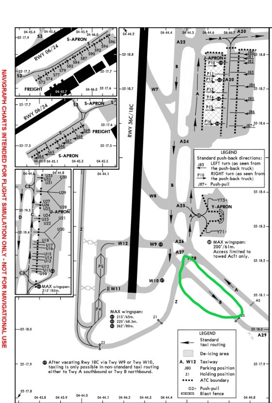
When i taxi here i dont see taxiway B. Taxiway A has a sign Q. Is that a chart problem or is the scenery not good here?
greetings
Marc

Hello,
When i taxi here i dont see taxiway B. Taxiway A has a sign Q. Is that a chart problem or is the scenery not good here?
greetings
Marc

the charts are correct. MSFS not always.
Moved to #self-service:scenery
You’re using a Jeppensen Taxi chart? MSFS will procedurally generate taxiway names and labels in some cases, so they will not always coincide. Use an EFB that reads the database directly - i.e., Little Nav Map.
yeah, i use a Jeppensen Taxi chart in Navigraph. I have the Premium Deluxe version of MSFS where EHAM airport is handmade. Thats why i am so confused missing a complete taxiway.
Personal Comments
I also have the Premium-Deluxe version. There is no guarantee that any airport will have corresponding taxiways to the real-world charts. I too have Jepp Charts through Navigraph, and while many airports match up, both Class 1 and 2, some do not. It’s just the challenge of having to find a way to procedurally generate 39,000+ airports.
Bit of a resurrection of this topic, but I happened to stumble upon it and figured I’d link to some additional information. In short, last year the single taxiway Q was largely split up into two taxiways as a step towards completing a full dual taxiway system around the terminal area. For more information, see here.
The MSFS scenery predates this extension, hence the mismatch between the current charts (which are correct) and the scenery (which is now out of date). I’d love to see Asobo revisit EHAM and include the new taxiway in the simulator, but I’m not exactly holding my breath. Especially not since the airport is also a hand-made one.
Thanks, that explains it!
This topic was automatically closed 30 days after the last reply. New replies are no longer allowed.