What you say about China is very true. But if you compare the position shift of Bing/Google satellite images to the map overlay, the difference is significantly larger. Also there are reports of similar ILS position issues at locations outside China as well.
I think there may be more too it, but I have no idea at the moment what it is.
1 Like
Think we need to check what countries this happens and what geodetic system they use? There are alot of weird systems in use around the world, maybe conversion error to WGS84?
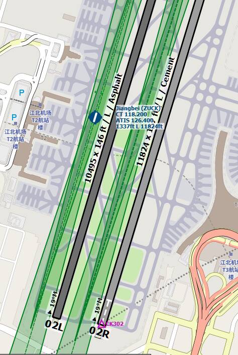
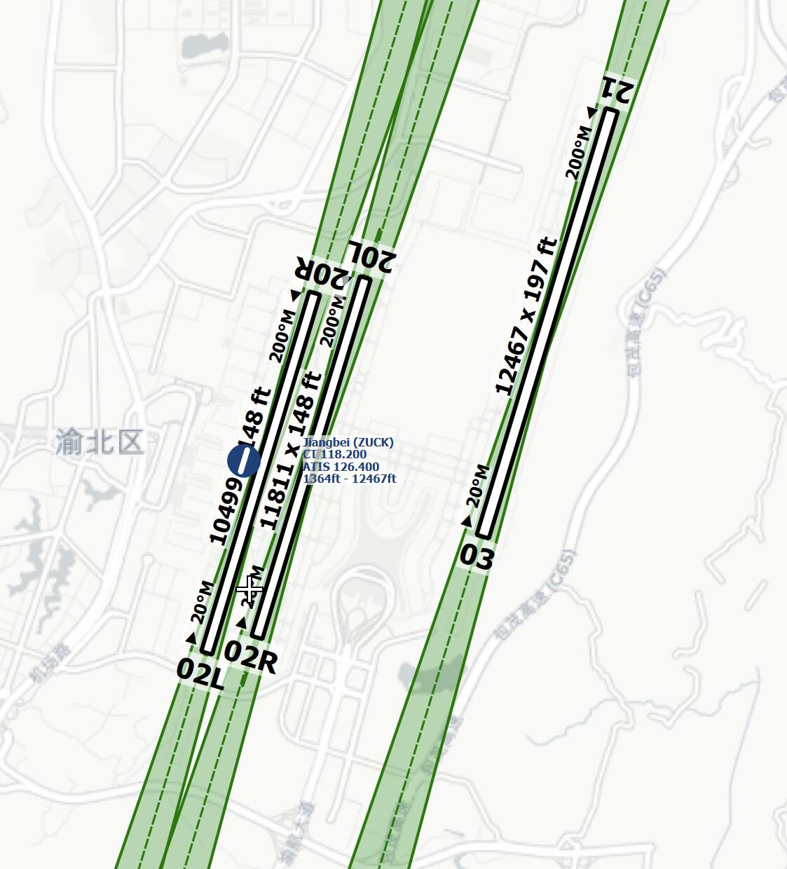
But the offset isn’t consistent. This is ZUCK.
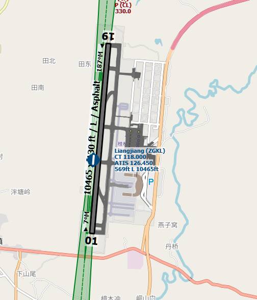
And ZGKL
So the offset seems to be different per airport. Anyway, it’s hard to find a correct one. If any. Apparently no one at Asobo ever checked. Maybe the big ones, like Shanghai and Beijing.
The offset introduced by the Chinese is also random if I understand it correctly. I don’t know if that actually is the problem but I won’t be surprised if it has something to do with it. Either that or different geodetic system.
I think @NAVData might know more about this.
Sorry,I have not read all postings now and I´m honest - I´m lost due the lot of different information. Therefore please excuse, when I can´t really help.
But what I have done now is, that I have looked on the both example with our Jeppesen data and here, I don´t see any offset:
- Here a screenshot, where I have ONLY loaded the MSFS bgl data (AIRAC 2105 rev. 4 installed) - you see this on the third runway, which are missing in the sim and therefore you have only the LOCs - no offset, the LOC is centerlined:
- The same, but with our loaded dataset for LNM (no MSFS bgls) - here again, same result no offset but the third runway is visible (ok, because this come from our LNM dataset) - so both datasets are working:
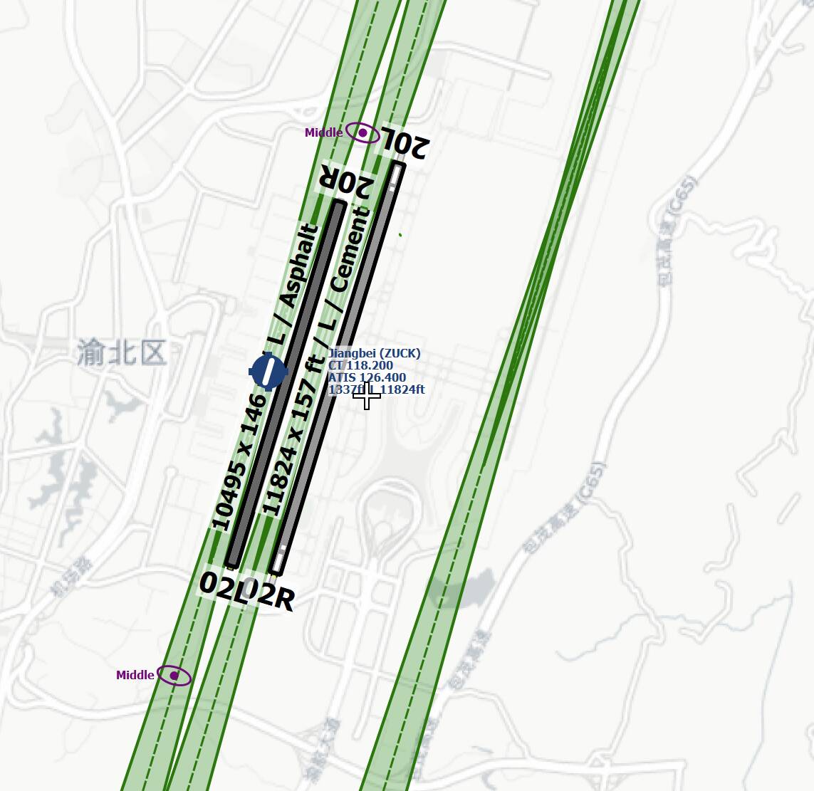
- Last a test with the mixed default bgl data from the sim, without our Jeppesen data. Here you see the offset of all ILSs (the crazy one, there is also the ILS for the third runway
 )
)
So, I have no clue, what ASOBO makes here and how they will interpret the data (or which datum code they internally use) but as you can see, the localizer position are simple not correct. In both cases, the Jeppesen data shows the correct position and the correct localizer, at least via LNM …
Sorry, I can´t really help here but it looks that our worldwide Jeppesen dataset works … the mixed FAA, NavBlue, possible some other freeware sources, … not. It is also possible, that exactly the mix of data sources produce this issue but what I have read here, that was long before they started to go away from the unified NavBlue data only.
Cheers
Richard
2 Likes
Thanks Richard.
Is there anything I can do as a MSFS user without any subscriptions to additional navigation data? Is this solvable within the sim somehow (apart from fixes by Asobo)?
P.S.: I do not fully understand why your first example with only MSFS has the correct ILS and my data (only MSFS) doesn’t. I do have the latest updates (I think).
I don´t know sorry … It´s a pity that we can´t really help here …
The first screenshot uses only our MSFS dataset (so, no stock data), which you can use when you have a subscription - the third screenshot uses the stock data only (without our data), for all without a subscription.
Thats what I have written - when you use our dataset (for MSFS and LNM) you will always have the same correct results. When you don´t use it and you use only the internal stock data, than you have the offsets.
Cheers,
Richard
1 Like
I’m now starting to think that maybe the ILS is correct, but the runways are misplaced… hard to tell… (EDIT: well, comparing the last two screenshots not so much actually… it does seem to be the ILS…)
I hope they tackle China soon in a WU or something… basically with the current data, ILS there is pretty useless.
No, the position of the localizer antennas in the mixed ASOBO stock data are wrong.
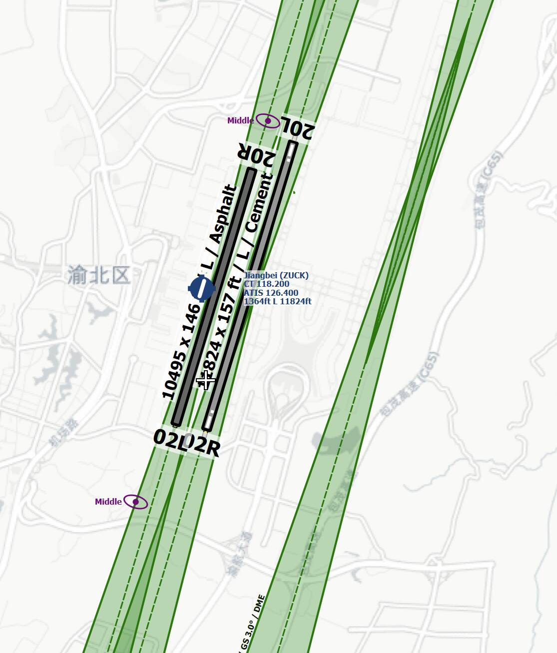
Here the positions from the stock data:
Localizer antenna position for ILS 02L/R:
Localizer antenna position for ILS 20L/R:
You see very clear, that the positions of the Jeppesen data are correct and center lined but the ILS position of the ASOBO data are completely off.
For your own cross-check:
Loc position ILS 02L:
Stock data: 29.73560281097889 / 106.64543598890305
Navigraph/Jeppesen data: 29.73463889 / 106.64694722
Loc position ILS 02R:
Stock data: 29.738983400166035 / 106.65068596601486
Navigraph/Jeppesen data: 29.73805833 / 106.65223333
Loc position ILS 20L:
Stock data: 29.703444465994835 / 106.63824990391731
Navigraph/Jeppesen data: 29.70246111 / 106.63990833
Loc position ILS 20R:
Stock data: 29.704374857246876 / 106.63450017571449
Navigraph/Jeppesen data: 29.70336667 / 106.63611667
… and by the way, there are a LOT!! such wrong positions - that´s not the only one (worldwide!)
Cheers,
Richard
2 Likes
Well this would go a long way to explain the numerous “My aircraft lands next to the runway” threads that continually appear here. (No autoland aside…)
This really needs some investigating by Asobo. How can it expect to be taken seriously as an IFR simulator with these sort of issues still present, nearly 1 year after release?
2 Likes
Yes, in China alone I could not find an airport without these problems. Beijing seems correct, but there I got weird results in the FMC when selecting one runway and getting the ILS for another one. I did not check Shanghai yet. And Hong Kong is correct. But all these regional airports seem off. Not sure if this is better in other countries. There’s also problems in the flight planner, where ILS runways are lacking but the ILS actually works on the airport.
Anyway… I hope Asobo picks up on this. I know complaining here doesn’t help, but I am getting a bit tired of all the sloppiness throughout this sim. It seems for almost everything you need a workaround.
Were those problems also present in older versions of the sim (FSX, FS2004 etc.), I don’t remember running into these problems before. Could it be some weird conversion error between geodetic systems? I haven’t run into this problem in Europe for example. Or maybe navdata providers…
I no longer have FSX on my system, but I would expect that the data was probably correct (where available) since Jeppesen was the official supplier of the core nav data for FSX and was (at the time) an official Microsoft partner. When MSFS was first announced, I assumed that Jeppesen would again be the nav data supplier. When I read last year that the partnership for this data would be with NavBlue my reaction was to say “Oh &#%”.
Having worked in r/w avionics support in corporate aviation for the last 30 years, and being well aware of NavBlue’s poor reputation among US-based aircraft operators who have used their navdata service, I knew there would be many problems - as has indeed turned out to be the case.
Imagine a professional limousine driver, whose employer has long operated a fleet of Mercedes automobiles, learning that the employer is going to replace all the vehicles with Yugos…
Fortunately, with Navigraph, we have the option to once again use high quality accurate base nav data in MSFS. I can certainly understand the objection of MSFS users who do not want to have to pay a subscription for updated in-sim nav data when the promise by Microsoft was that this data would be supplied and regularly updated for free. Unfortunately, as long as the partnership continues to be with NavBlue, I don’t see this situation getting any better. The recent addition of FAA CIFP data to supplement NavBlue was a step in the right direction - but that additional data only covers the US.
For those familiar with the climactic scene in the movie “Indiana Jones and the Last Crusade”, when it came to picking a nav data supplier for MSFS, Microsoft “Chose poorly”.
1 Like
We use NAVBLUE “chart+” as a chart service and I have to say, it is a million times better than Jeppesen (at least in European airspace). It even has the option to display the operators contingency procedures right on the departure charts, its really excellent. I don’t know about their other services. Our FMS database runs via Honeywell and its quite crappy.
I wouldn’t necessarily object to paying extra for a subscription, but the thing is that I was hoping with this sim to have it all in one program. I got a bit tired with FSX to startup first 3 separate programs (two for the weather) etc… it was a whole bunch of extra software. Then additional flight planning that didn’t coincide with ATC, etc. Extra installs, updates here and there… before you were flying an hour had passed.
With MSFS the promise seemed to be that was no longer necessary. Everything bundled. The weather I’m happy with. But the flight planning is horrible. ATC really didn’t progress a lot since FSX. Then add these ILS problems…
Ah well. More visual approaches
Maybe in the coming years.
In Europe, from my understanding, their data is quite good. That is definitely not the case with their data for the US and Canada. Somewhat ironic, considering that the original company (NavTech) that was merged with others to form NavBlue, is based in Canada.
Missing approaches is bad enough, but sometimes they have to be deleted from r/w AIRACS due to FMS memory constraints. There is no such memory constraint in a flight sim of course. But, the absolute “unforgivable sin” for a RTCA DO-200- certified navigation data supplier is to include obsolete data in their product, and that is, and continues to be, an ongoing issue in r/w NavBlue AIRACS for the US. There is something seriously wrong with their parsing and quality control of base ARINC-424 data for the US, and they have been sanctioned by the FAA more than once for this.
So Jeppesen navdata for US and Canada, Navblue navdata for Europe, Some other providers for other parts of the world and problem solved 
 .
.
I guess it doesn’t matter from which provider the navdata comes, as long as it is correct. But I really don’t want to have anything to do with the cluttered mess that are called Jeppesen charts  .
.
I suspect that the NavBlue data supplied for the US may be based on the AIRAC for a specific r/w aircraft FMS, rather than including “everything” from the ARINC-424 master files as Navigraph does. That would account for the large number of missing procedures at US and Canadian airports - especially small to mid sized ones. I have not seen any major problems with the NavBlue data for major international US airports.
I think the runways are not correctly positioned by Asobo.
When I switch between pure Navigraph data and airports from the sim data in LNM I can see the runways are not in the same position.
It’s probably a mix. For some of them it’s just the ILS (see the above discussion). But in the MSFS data the airports can be a mess too. ZPPP is infamous. The airport is bonkers, but the ILS is working. The old airport is closed, but that’s where the flightplan takes you.
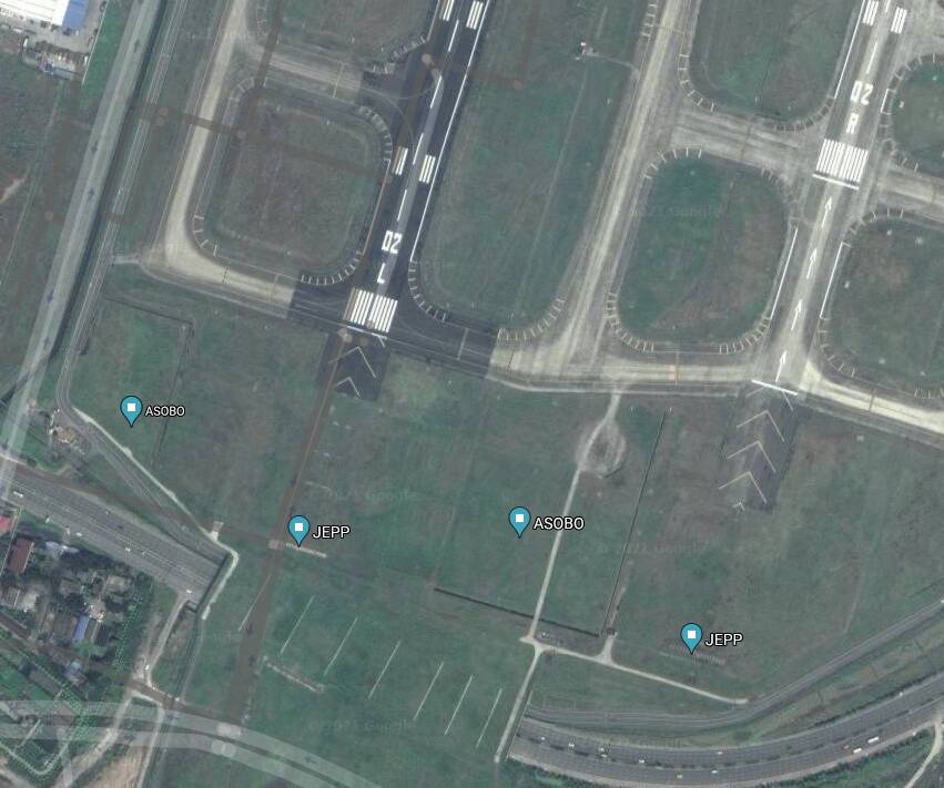
ZPPP (new airport):
So I don’t fully understand how they can put in the ILS for an airport that looks like that. They need an intern to just go over all these airports and check, or use a source that gets it right.