Pee-Wee’s Little Adventure #2
The Flight of the Ancient Mariner, Part 1
Welcome back and Happy New Year, everyone! The weather across the States was uncooperative around the holidays, so Nag is exhausted and not in the mood to write or explore…or anything involving airplanes, really! Looks like it’s time for another Pee-Wee’s Little Adventure! ![]()
Today I’m heading to Land’s End on the tip of Cornwall, then across a mythical land from Arthurian legend to the nearby Isles of Scilly (pronounced “Aisles of Silly,” which sounds like a really awesome shopping experience). I’ve visited all three places in real life but never in MSFS because there was something missing. Well, that something showed up a few days ago:

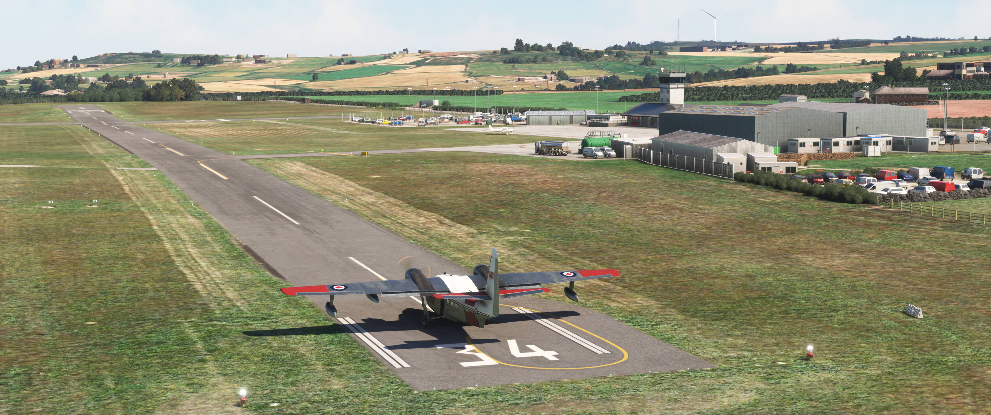
Microsoft’s HU-16E Albatross, courtesy of the Marketplace’s holiday sale. The Albatross came highly recommended by a trusted online friend, and I’m happy to say that I still trust him! Microsoft did right by the big Grumman: she’s the work of Mike Johnson (a.k.a. Lotus and @Ramasurinen), the famed creator who brought us the amazing Lotus Simulations L-39 for FSX. As expected with such talent at the helm, she looks and flies great, and everything works as it should.
The Royal Canadian Air Force operated ten “long wing” HU-16Bs with more powerful R-1820-82 engines and a snow ski concealed in their keels. Known locally as CSR-110s, they were the first purpose-built search-and-rescue aircraft purchased by Canada. This is serial number 9310 as she appeared shortly after delivery to 111 Communications and Transport Unit (111 KU). She went on to serve the Fuerza Aérea de Chile and the Royal Malaysian Air Force and was displayed at Ipoh Air Base until the early 2000s when she was apparently scrapped.
The Pisces in me loves a good flying boat, and this one’s a keeper. Fast, easy-handling, and designed for the open ocean, she’s the perfect mount for today’s maritime-themed tour. I highly recommend flying a seaplane or amphibian: some of the sites are best viewed from the water!
MSFS’s base scenery for the Isles of Scilly is nothing to write home about, but there are some third party addons available. My fellow 2020 users have two options: SuperSpud’s and the more recent offering from RealVFR. SuperSpud’s is the more complete package. RealVFR’s looks very nice but conflicts with Orbx’s Great Britain South. I went back and forth several times but finally settled on SuperSpud’s scenery for this tour. (Remember to install the complimentary scenery packages listed on the download page, like mgk07’s Isles of Scilly Shorelines.)
For my brave 2024 users, the only choice is the RealVFR package. Good news: SuperSpud’s excellent Land’s End Airport is compatible with both sims!
How about some waypoints?
| Waypoint | LatLong | Skyvector |
|---|---|---|
| Land’s End Airport | EGHC | |
| Cape Cornwall | 50.1275 -5.7071 | 500739N0054225W |
| Sennen Cove | 50.0862 -5.6940 | 500510N0054139W |
| MV RMS Mülheim | 50.0734 -5.7084 | 500424N0054230W |
| Land’s End | 50.0691 -5.7167 | 500409N0054300W |
| Wolf Rock Light | 49.9453 -5.8064 | 495643N0054823W |
The winds at Land’s End favored 2,572-foot (784-meter) Runway 34, a narrow strip of rolling asphalt aimed toward St. Just and the Cot Valley. Yes, the runway has some ups and downs but wait until you see St. Mary’s! Takeoff was a fingers-crossed affair: this was one of my first flights in the Albatross and I was only reasonably certain the runway was long enough for two people, a dog, some bags, and 680 gallons of gas! (Spoiler alert: it was.)
Flying started at Land’s End in September 1937 when Channel Air Ferries began once-daily service from here to the golf course on St. Mary’s in the Scillies. The airline’s Dragon Rapide lived in a hangar brought 400 miles (643 kilometers) from Squires Gate Airport in Blackpool until former Aer Lingus Dragon G-ACPY arrived in 1938 when the service was taken over by Great Western & Southern Airlines. Quite controversially, ACPY was shot down by a passing Luftwaffe He-111 on 3 June 1941. The pilot and five passengers—a vacationing husband and wife, their two children, and mother-in-law—were killed.
BEA took control in 1947, and its trusty Dragon Rapides remained on until May 1964 when they were replaced by Sikorsky S-61N helicopters flying from the Penzance Heliport seven miles (11 kilometers) to the east. Fixed-wing service returned with Scillonia Airways but was gone again by 1969. Another fifteen years passed before Skybus began serving the Isles with Islanders and Twin Otters. Today both the airport and Skybus are owned by the Isles of Scilly Steamship Company.
Scillonia’s Dragon Rapide G-AHAG still flies from Membury, beautifully restored in the airline’s pleasing white and turquoise colors.
Enough chatting. Let’s get going!

 So Many Acronyms: Cape Cornwall
Right after takeoff you’ll see St. Just ahead and the Cot Valley dropping toward the Celtic Sea. The valley’s mild microclimate attracts several types of large birds including buzzards and Cornish choughs (pronounced “chuffs”), and seals are routinely seen sunning on the shore beneath the valley’s mouth. I flew a wide teardrop course reversal to the northwest and followed the rugged sea cliffs southbound. Stay low: if you’re flying above 500 feet (150 meters), you’re probably missing something!

That’s Cape Cornwall down there, where the Celtic Sea meets the English Channel. Atop the rocky headland is (1) The Stack, part of the abandoned Cape Cornwall Mine. Cornwall may be a beautiful tourist destination today, but in the late Nineteenth Century it was a mining powerhouse, producing copper, lead, and nearly two-thirds of the world’s tin. At the height of the Industrial Revolution, twenty-five percent of Cornwall’s population worked the mines, the remains of which are visible up and down the coast today.
In 1987, the Heinz Company (maker of Great Britain’s most famous snack food) purchased Cape Cornwall and donated the land to the National Trust. Today, this area is part of the Cornwall Area of Outstanding Natural Beauty (AONB).
Yes, that’s an official designation! Many locales in the United Kingdom are designated Areas of Outstanding Natural Beauty (AONB), Biological or Geological Sites of Special Scientific Interest (SSSI), Areas of Archaeological Importance (AAI), and Regionally Important Geological Sites (RIGS). The tip of Cornwall is part of the Cornwall AONB and the Aire Point to Carrick Du SSSI. We’ll visit the Isles of Scilly AONB later.
South of the Cape is (2) Priest’s Cove, famous for having nothing to do with priests but for attracting brave swimmers who race annually from the nearby Brisons back to the beach here.
Cornwall isn’t just abandoned mines. All along the coast are heritage sites like (3) St. Helens Oratory, a pre-Reformation church and prayer oratory standing on the grassy slope overlooking (4) Porthledden. The chapel’s original cross was apparently taken to St. Just and later tossed down the vicarage’s well. (Why, nobody knows.) The current cross was found nearby and placed atop the southern gable.
The abandoned (5) Boswedden tin and arsenic mine lies near the mouth of the Kenidjack Valley. Powered by the Tregeseal River, the mine’s 65-foot (20-meter) water wheel was once the largest in Cornwall.
Atop the headland to the north is (6) Kenidjack Castle, one of eighteen Iron Age “cliff castles” carved from the underlying granite along the Cornish coast. They were evidently occupied until the Roman Era and in some cases even later, although their exact purpose remains a mystery. During World War 1, Kenidjack was used as a rifle range by the local militia.
Way off in the distance is the smokestack from the short-lived Allens Shaft Botallack Mine. Sinking of the main shaft began in about 1906, but like many tin mines along the this coast, the main lodes were located out of reach offshore, and mining ended here in 1914. An abortive attempt to revive the mine and reach the inaccessible deposits in the 1980s ended when the International Tin Council failed and global tin prices collapsed. The main shaft sinks about 1,400 feet (426 meters) below ground, one of the deepest mines in Cornwall.
Many Cornish miners left for greener shores when the mining industry began its long decline, with thousands taking their skills to the booming mines in the United States, Australia, and South Africa. Between 1861 and 1901, nearly one-fifth of Cornwall’s men emigrated overseas each decade! An estimated six million people worldwide—2.5 million in the United States alone—are descended from Cornish immigrant miners.
 Not for the Faint of Heart…or Visitors: Gwynver and Sennen Beaches
Cornwall is a maritime county, bordered on three sides by the Celtic Sea, Bristol Channel, and English Channel, with about 430 miles of coastline. The National Maritime Museum, Cornwall is located at Falmouth harbor and features not only historic Cornish boats but hundreds of small watercraft from around the world.
Cornwall’s commercial fishing industry is thriving, but not because of national interest. Nearly 80% of the county’s catch is exported to mainland Europe, and especially to France where cheaper Cornish shellfish are highly prized.
Millions of holidaymakers swarm Cornwall’s white sandy beaches and rugged coastline annually, contributing upwards of 15% to the county’s economy. Cornwall is also the epicenter of the UK’s thriving surfing community. All along the county’s north shore and continuing on to Scotland, you’ll find beaches with consistent waves driven by the powerful Atlantic swell. Every year, thousands of people flock to Newquay for the Boardmasters surf competition and music festival and Surf England’s English National Surfing Competition at Fistral Beach and Watergate Bay below RAF St. Mawgan/Newquay Airport.
If you plan on joining the lineup here, bring your wetsuit: the average water temperature is a chilly 62°F (17°C) in the peak summer months, but plunges to an absolutely bone chilling 50°F (10°C) in winter. ![]() I love surfing, but when it’s that cold, you’ll find me back at the lodge, sitting in front of the inglenook, wrapped up to my eyeballs in my favorite quilt and nursing a hot cocoa!
I love surfing, but when it’s that cold, you’ll find me back at the lodge, sitting in front of the inglenook, wrapped up to my eyeballs in my favorite quilt and nursing a hot cocoa!

I’m passing abeam (1) Land’s End Airport in this northeast-facing photo. Cornwall boasts more than three hundred beaches, and here inside Sennen Cove are (2) Gwynver and (3) Sennen Beaches. Separated only by a slight rock outcrop, these two beaches may as well be on different continents! At Sennes you’ll find consistent waves for surfers at all experience levels, and several surfing schools operate from its beautiful white sands. The scene at Gwynver is completely different: exposed to the full brunt of the Atlantic swell, the waves here are much less forgiving and with the underlying sands shifting daily, a good run one day may be unrideable the next.
Also, like so many surf spots worldwide, Gwynver is, in my experience, cursed with a particularly unwelcoming group of locals. (If you’re ever here and meet the obnoxious stubby ork with the tie-dyed Hypto Krypto and a bloody nose, tell him he deserved it. ![]() )
)
This is our first good look at the (4) South West Coast Path, Britain’s longest waymarked long-distance hiking trail. Built for Coastguardsmen to patrol for smugglers, the path meanders along the shores of Somerset, Devon, Cornwall, and Dorset for more than 600 miles (965 kilometers) from Minehead to Poole Harbour. I’ve hiked many miles of this wonderful trail, but never the whole length, which at my average pace would take about nine non-stop days. Gonna’ need some new sneakers. ![]()
Oh, and be careful near the terminus at Poole Harobour. The path crosses Studland Natural Beach. “Natural beach” is the English term for “clothing optional.” Yikes! ![]()
Smuggling was another leading industry in Cornwall during the 18th and 19th Centuries, so much so that some historians estimate that more alcohol entered England illegally through the Cornish coast than approved channels in London! Cornwall was home to the likes of Zepheniah Job, the “Smuggler’s Banker” who, among his legal business activities, encouraged and bankrolled significant smuggling operations; John Carter, the honest “King of Prussia” who operated from Porthleah (now named Prussia Cove in his family’s honor); and “Cruel” Coppinger, a hulking Dane who shipwrecked here and decided to form his own gang of “free-traders.”
With so many ships foundering along the Cornish coast, wrecking—the illegal salvaging of cargo from sunken or grounded ships—was common. Smugglers earning their livings in this trade were dubbed “wreckers.”
Most of the (5) homes in the tiny hamlets of Escall and Mayon overlooking Sennen Cove are vacation rentals. Prices range from the high $100s (£75) for a nook beneath someone’s stairs to upwards of $500 (£370) per night for a two-bedroom affair in the shoulder season.
Our next site is just around the bend at Sennen Cove. You should probably slow down: it comes up quick and his hard to see! (Oh, by the way, it’s a shipwreck, but nobody got hurt and the story is pretty funny, so I won’t blur this section out. Read on!)
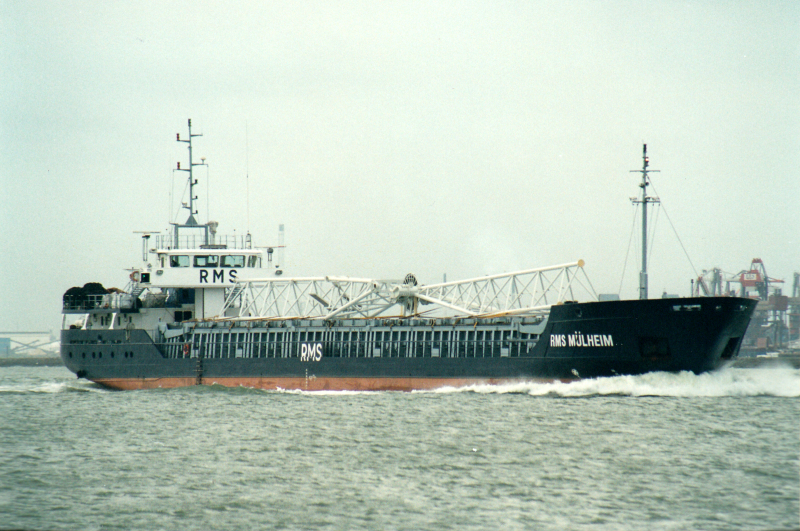
 Explain That to the Insurance Company: MV RMS Mülheim
The four-year-old German dry goods carrier RMS Mülheim was enroute from Cork, Ireland to Lübeck, Germany with a load of recycled automobile plastics when she ran aground south of Sennen Cove before sunrise on 22 March 2003. The crew of six was airlifted without injury from the stranded ship by a Sea King from nearby RNAS Culdrose, but the hapless freighter remained on the rocks until she finally broke apart.
“RMS” doesn’t mean Royal Mail Ship in this case. The Mülheim’s operator was Rhein-Maas-und See Schiffahrtskontor (RMS).
Prior to the grounding, the ship experienced no mechanical abnormalities, and the weather was quite agreeable. So, how did a perfectly good ship in perfectly good weather crash headfirst into Cornwall? The answer is simple:
Pants.
Investigators discovered that the single watch officer’s pants tangled in the master’s chair causing a fall that rendered him unconscious. When he came to, Mülheim was bearing down unavoidably on the rocky shore.
Yup…pants. (I can’t make this stuff up. ![]() )
)
Over the next few weeks, the ship’s fuel and a significant portion of her cargo were salvaged. Declared a constructive loss, the ship was abandoned to her fate. During the week of 7 October, the ship’s bow separated and fell into the sea, and on the last day of the month, another storm smashed Mülheim’s battered remains deeper into Gamber Bay where she lies today.
In marine insurance, “constructive loss” means that the cost of repairing the insured vessel exceeds the insured value. In aviation, we say “damaged beyond repair.” Vessels that are physically lost (i.e. sunk) are considered “actual total losses.”
During the subsequent litigation, the ship’s owner was fined for not maintaining the required two-man watch during night hours. Twenty-two years after Mülheim ran aground, a large portion of the ship’s stern remains on Gamber Bay’s rocky shore and is visible from the South West Coast Path.

It’s also (1) visible in MSFS, beneath the (2) Maen cliff castle. Scenery developer mgk07 published a MSFS2020 watermask improvement package for Cornwall that makes the wreck easier to see, but unfortunately, it’s currently broken and creates a deep chasm behind the cliffs here.
 The 874 Mile Hike: Land’s End
Humans love extremities—the furthest this, the tallest that, the fastest whatsit—and so it is with geography. Projecting into the sea from the very tip of Cornwall, Land’s End is the westernmost point of mainland England, and whatever the season, it’s a breathtaking place. Standing atop the towering cliffs with all of England behind and nothing but open ocean ahead feels like standing at the bow of a great sailing ship, and like Jack and Rose, you’re the King of the World.
Just ignore the tourists with their souvenir shirts, “Land’s End” rocks, and Cornish pastys jockeying for the best selfie behind the tourist plaza. ![]()
For a more secluded experience, visit the UK’s other extremities, like Lizard Point, the southernmost point of mainland England just around the bend from Land’s End, or my favorite, Dunnet Head in Caithness, the northernmost point in mainland Great Britain.
Chicago businessman Gary Comer and his associates named their mail-order yachting supply and clothing company after Land’s End in Cornwall. Unfortunately, none of them noticed the misplaced apostrophe until after thousands of the company’s first catalogs were printed and ready for mailing. Unable to afford another printing, they leaned into the error, officially adopting the name Lands’ End!

Well, this looks…amazing.
The Tour of Dr. Syntax in Search of the Picturesque is an 1809 satirical poem written by British author, debtor, and general hack William Combe. The poem follows the misadventures of the eponymous clergyman and headmaster as he travels the Green and Pleasant Land in search of the “picturesque,” a play on the famous works of artist William Gilpin. Dr. Syntax is considered to be the world’s first real cartoon character.
A large rock here looks like Dr. Syntax’s head…if you squint just right!
(Hint: in the linked photo, Syntax is looking down and to the right.)
Other formations nearby are (2) Goose Slade Point and (3) The Armed Knight, both of which are completely pancaked in MSFS. Here’s the (4) South West Coast Path again, winding its way toward (5) First and Last House. Believed to date from the early 19th Century, the building was used from 1860 by Ms. Gracie Thomas as the “First and Last Refreshment House in England” and souvenir stand. It’s been expanded since then and today’s souvenirs are probably made in China, but the First and Last House is still a place for a nice cuppa and a bowl of locally sourced ice cream.
Here’s the newer (6) West Country Shopping Village, Bakehouse, Experience Shop, and Land’s End Hotel. MSFS’s autogenerated buildings make this tourist trap look about as inviting as a super max prison, or perhaps post-meltdown Pripyat.

With Orbx’s GB South installed, you’ll see the famed “Lands End” marker overlooking Longships Rocks. The distances on the sign are mostly self-explanatory: 3,147 miles across the Atlantic to New York City, 28 miles to the Isles of Scilly, and 1.5 miles to Longships. But who is John o’ Groats and why do we care how far he is from Land’s End?
John o’ Groats is the village in County Caithness, Scotland, commonly recognized as the northeastern extremity of Great Britain. The road trip from Land’s End and John o’ Groats traverses 874 miles, the longest distance between extreme points of Great Britain. Yes, there’s a matching sign in John o’ Groats.
For comparison:
New York City to Milwaukee = 880 miles
Los Angeles to Boise = 841 miles
Paris to Rome = 885 miles
Berlin to Cherbourg = 831 miles
Longships Lighthouse should be visible on the distant rocks, but with SuperSpud’s Orbx-cooperative scenery installed, it’s absent, one of several compromises we must accept for adequate scenery in this area.
That’s it for mainland Cornwall! Our next point lies about eight miles southwest of Land’s End in the English Channel. The next thirty miles are over water, so any unplanned landing will result in getting your feet wet. Check your fluids (fuel, oil, bladder)!
 The Swamp King Would Be Proud: Wolf Rock Light
Rising sharply more than two hundred feet to the water’s surface eight miles southwest of Land’s End is notorious Wolf Rock, a Cretaceous volcanic mount unlike any other in Cornwall. Notorious is an inadequate adjective for this inhospitable crag, for littering the seabed here are the wrecks of hundreds if not thousands of sailing ships whose hulls were mangled and shredded by the Wolf’s phonolite teeth.
Atop the rock stands the Victorian era Wolf Rock Light. Completed in 1869, this 135-foot (41-meter) granite sentinel is at least the fourth marker built here, the others being short-lived “daymark” affairs that were swept away almost immediately by the raging Atlantic. Only the earlier conical metal daymark completed in 1848 remains today.
The rock is named for the sound it once made. For centuries, seawater pushed by the Atlantic swell forced air through a peculiar horn-shaped outcrop here, generating a distinctive howling sound reminiscent of a wolf’s call. Unfortunately, the opening was plugged by Cornish wreckers who realized that the sound—a natural warning for approaching ships—was sinking their profits!
The Wolf Rock Light holds a special place in aviation history: it’s the first lighthouse anywhere equipped with a helicopter landing pad atop its tower. Added in 1972, the pad is landable in MSFS.
For the military historians here, Wolf Rock boasts another claim to fame, being the only lighthouse credited with sinking a submarine! On 18 December 1944, the German U-1209 ran aground on Wolf Rock in broad daylight, supposedly during a heated “navigational disagreement” between the boat’s captain, who thought the submarine was west of Wolf Rock, and the navigator, who knew they were approaching it. Refloated by the waves, the mortally wounded submarine drifted to the east and was scuttled by her crew. Nine men, including the captain, were lost while the others were rescued by the Canadian destroyers Montreal and Ribble, and Royal Motor Lifeboat (RML) 542 from Newlyn.
Oh, for those of you wondering, the navigator was right. ![]()

No annotations this time. (If you can’t find the lighthouse in this photo, there’s nothing more I can do for you.
A keeper’s life on Wolf Rock was miserable isolation, and relief was often delayed for weeks by storms that kept small motor launches away. I’m certain the “all-weather” helicopter pad was a welcome addition! Automation came in 1988 and today the Wolf’s only visitors are mechanics and seagulls.
Did you understand my Swamp King reference? If so, respond here and receive thy laurels!
Gosh, I guess this isn’t going to be such a little adventure after all! This seems like a good place to take a break. Everyone toss out your sea anchors and hit the head. I’ll see you all back here for Part 2 very soon.
Bye for now! ![]()