Pee-Wee and Nag's Sky Tours (and Other Thoughts)

Pee-Wee and Nag at the Movies

Strategic Air Command, Part 2


Pee-Wee says: Welcome back, everyone! Let’s continue our tour of Strategic Air Command filming locations. Today we’ll visit not only the first home of the Air Force’s wonderfully sexy B-47 Stratojet, but also the winter home of the St. Louis Cardinals.

We added three interesting sites not related to the movie, so here’s the updated list of waypoints.

Waypoint Coordinates Lat/Long (Skyvector)
Al Lang Field / Albert Whitted Airport (KSPG) 27.7689 -82.6331 274608N0823759W
Sunshine Skyway Bridge 27.6205 -82.6552 273714N0823919W
Peter O. Knight Airport (KTPF) 27.9150 -82.4505 275454N0822702W
American Victory Ship & Museum 27.9437 -82.4441 275637N0822639W
MacDill Air Force Base (MCF) 27.8458 -82.5072 275045N0823026W

Pee-Wee says: We’ll start at Albert Whitted Airport in St. Petersburg and work our way across Tampa Bay to MacDill Air Force Base. Feel free to fly whatever airplane you want for this tour. Once again, there are no short or soft field landings, no water landings, and no long legs, although the longest is over water. And, yes, the runway at Peter O. Knight is short, but you’d be amazed by the size of airplane that can land there. (Ooh…foreshadowing! :wink:)

One important note: it seems that as of November 2nd, YouTube has unfortunately removed Strategic Air Command, probably because too many people were watching it! It’s still available from other sites and for rent from YouTube.

Pee-Wee says: That means all of the video links I created over several days are dead. Sorry, everyone.

And you put so much work into those links.

Pee-Wee says: Sadness. :cry:

Such is the nature of YouTube and the ens##tification of the Internet. You should take a deep breath, watch thiery minutes of advertisements for laundry detergent and divorce attorneys, and enjoy some crummy AI-generated videos of dogs saving babies from orangutans with chain saws.

Pee-Wee says: I’ll pass. 3DBotmaker has a new DRC-X video, so I’m still happy as a Mustang at a parade! Anyway, let’s get started. I know you’ve been waiting to say it, so go ahead… :face_blowing_a_kiss:

Thanks. Let’s play ball!


:one: Not the Call Up He Expected: Al Lang Field

Strategic Air Command’s main character is “Dutch” Holland, a veteran combat pilot and the St. Louis Cardinals’ newest third baseman. The film opens with Sally Holland and her reverend father arriving at St. Petersburg’s Al Lang Field on the west shore of Tampa Bay. Inside, Dutch and the Cardinals are warming up for an intersquad game.

Al Lang was a busniessman and mayor of St. Petersburg who worked tirelessly to not only beautify and grow his city, but to attract major league baseball teams to Central Florida. Because of his efforts, fifteen teams–the Grapefruit League–still train in Florida today.

Pee-Wee says: The Cardinals seen in the movie are the actual 1954 St. Louis Cardinals! Look carefully and you’ll see pitchers Hal White (#26*) and Tom Poholsky (#23) warming up, shortstop Dick Schofield (#19) playing the part of the rookie “Brewster,” veteran catcher Del Rice (#18), and shortstop and future manager Solly Hemus (#7).*

Like Dutch, several of the real '54 Cardinals were veterans of World War 2. Solly Hemus served four years as an aviation ordnanceman aboard aircraft carriers. Hal White was the Navy’s Recreation Director on Guam and played exhibition ball while Cot Deal (#22*) was a physical education instructor and ball player at Enid Army Flying School.*

That’s Stu Miller (#36*) taking the mound as the B-36 roars overhead. He served postwar aboard CVL-48* Saipan as an Navy aerologist. Here he is standing with his shipmates, third row, fifth from the right. Gosh, I love the Internet! :blush:

Wow, that was a deep rabbit hole.

Pee-Wee says: Throw me a rope! :wink: Here’s a fun fact: in 1954, the oldest major league baseball player was the Cardinals’ Al Brazle (#27*), but if we assume the character Dutch Holland was the same age as Jimmy Stewart, he would have been three years older than Brazle. Dutch’s number was* #43*, which was Brazle’s age at the time of filming.*

Huh. I didn’t know that, and I had no idea you liked baseball so much.

Pee-Wee says: Oh, I don’t.

Really? But you spent hours researching all of that.

Pee-Wee says: I just really like looking into things that I know nothing about, and let me tell you, no organization keeps statistics and historical records like professional baseball! Sorry baseball fans, but while I love a good ballpark hotdog, I’d rather watch paint dry. :face_with_peeking_eye:


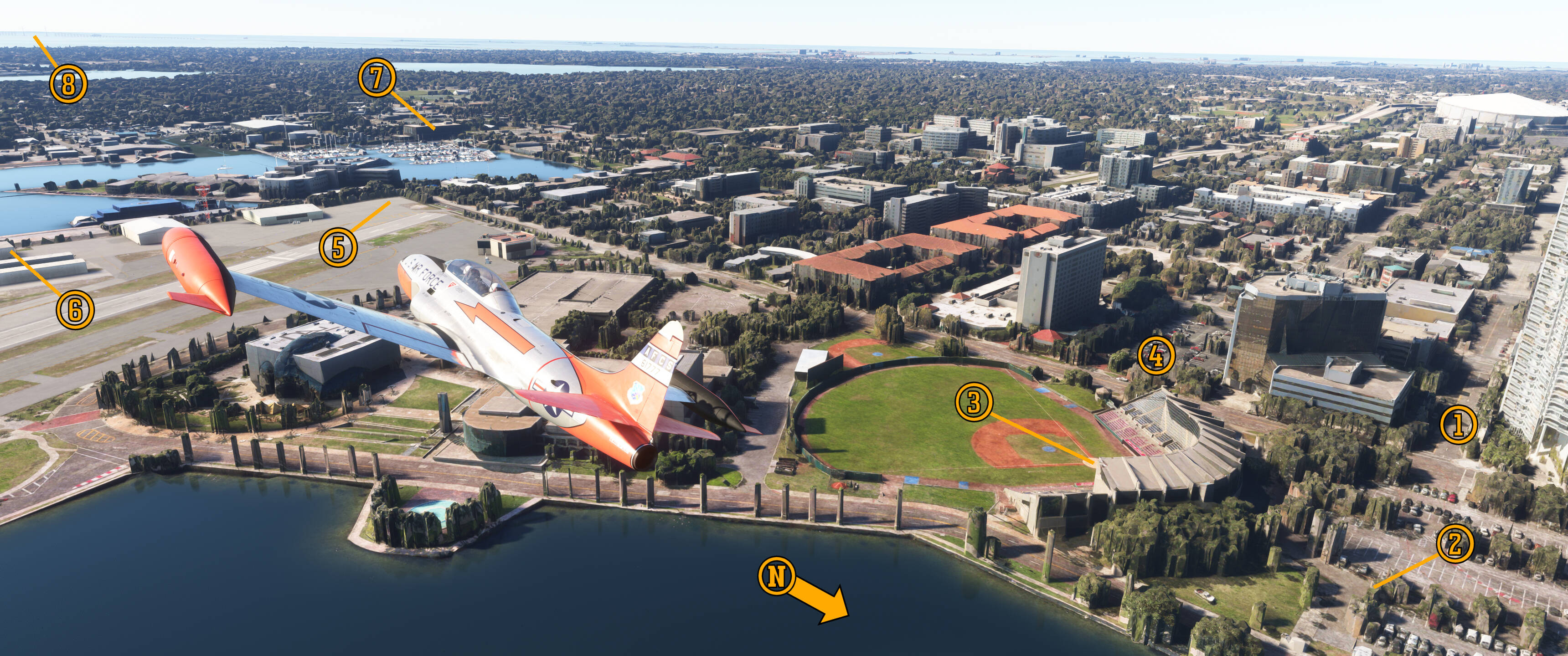
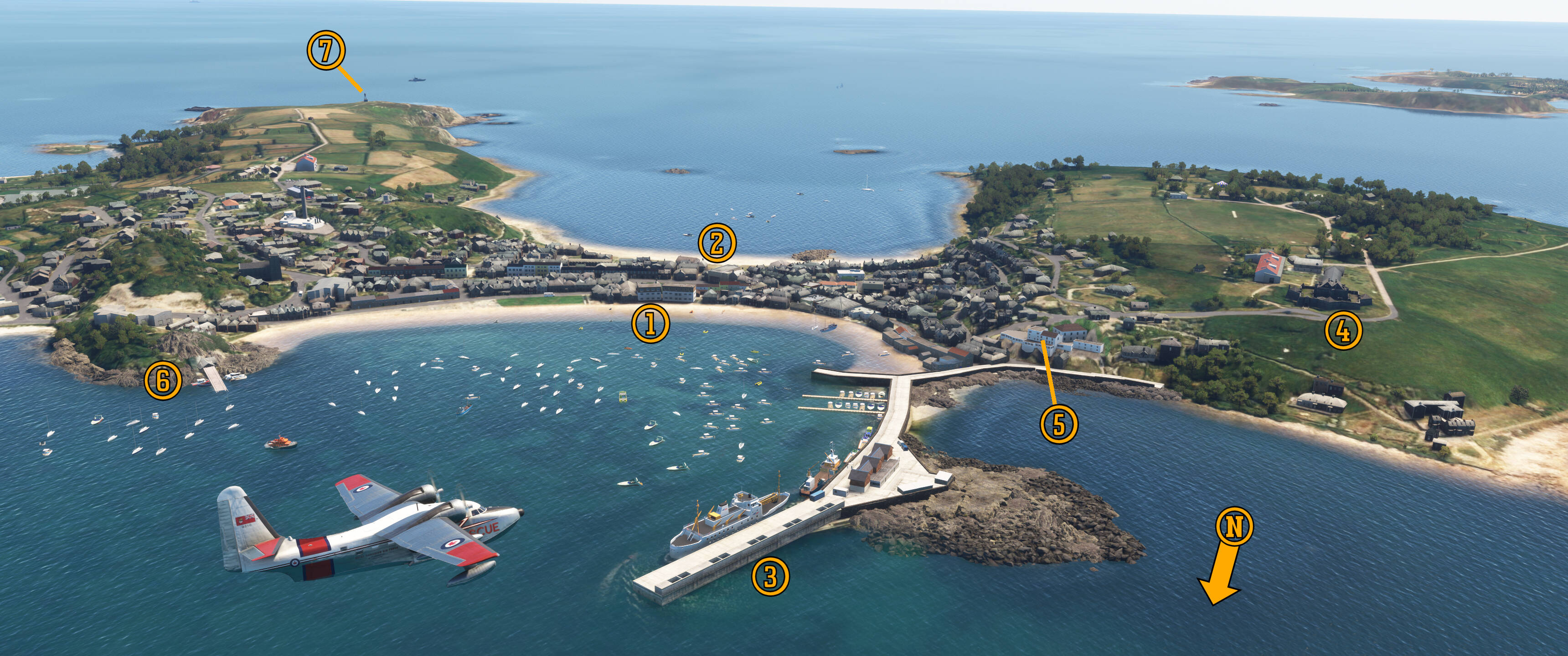
Pee-Wee says: The movie opens looking west along (1) 2nd Avenue as Sally and her father park (2) Sally’s new Cadillac curbside at Al Lang Stadium. Built in 1947, the stadium was replaced in 1976 by the more modern facility visible in MSFS. Built slightly further south, the new (3) home plate is located just inside the 1947 stadium’s second base, which means most of the spots where the action happens in Strategic Air Command lie beneath the new stands.

The historic West Coast Inn stood (4) here, overlooking the stadium from the corner of 3rd Avenue and 1st Street. On 25 March 1935, Babe Ruth hit possibly the longest home run in baseball history at Waterfront Park, St. Pete’s original original baseball field located in what is today the stadium’s parking lot. The Sultan of Swat hammered the ball an astronomical 610 feet (186 meters) onto the West Coast Inn’s second floor balcony. The historic hotel was demolished in 1967 and replaced by another parking lot.

Pee-Wee says: That last sentence sums of Florida in a nutshell. :roll_eyes:

To the southeast and visible in the movie when Sally and her father take their seats is Albert Whitted Field, one of the oldest airports in the United States. Albert Whitted was one of the Navy’s first aviators and a storied promoter of aviation in his native St. Petersburg until his death in an airplane crash near Fort Walton Beach in 1923. Five years later, St. Petersburg named its new airport in his honor.

On New Year’s Day 2014, famed aviator Tony Jannus flew a paying passenger from St. Petersburg to Tampa aboard St. Petersburg–Tampa Airboat Lines’ “Lark of Duluth,” the world’s first scheduled commercial airline flight. Thirteen days later, Jannus flew the world’s first commercial cargo flight, carrying a load of hams and bacon to Tampa. During its short existence, SPT’s two Benoist XIV’s flying boats carried 1,204 passengers and sightseers around Tampa Bay without accident or injury.

Pee-Wee says: It’s pronounced “ben-WAH.” Tom Benoist built 106 airplanes before his untimely death in a freak trolley accident in June 1917.

Although that historic first flight launched from the Central Yacht Basin to the north, many consider Alfred Whitted the birthplace of commercial aviation. Today, a memorial and replica Benoist XIV stand on the site of SPT’s hangar, and a magnificent replica Lark of Duluth hangs in the EAA Museum at Oshkosh.

Pee-Wee says: Albert Whitted is where one of my favorite airlines, Ted Baker’s National Airlines, was born. The field also boasted its own Goodyear blimp!

And I’m sure you’ll tell us about it in excruciating detail.

Pee-Wee says: Dang. Shots fired! :unamused_face: Anyway, Goodyear’s NC-11A Vigilant arrived at its (5) new hangar at the corner of 8th Avenue and 1st Street in December 1929 but was wrecked in northeast Alabama the following November. Vigilant’s loss and the deepening Depression ended St. Pete’s airship dreams, and the truncated hangar was relocated (6) further east in the late 1940s and removed altogether in 1999.

See? I can be brief. You may carry on now. :blush:

Wow. I’m impressed! As Sally and her father head to their seats, the three smokestacks of Florida Power Corporation’s (7) Bayboro Plant rise above the trees beyond right field. Bayboro was one of two plants powering Pinellas County when Strategic Air Command was filmed in 1954, nine years before an oil fume explosion destroyed the center smokestack. Shuttered during the 1973 oil crisis, the repurposed building’s current tenants include an environmental reconstruction organization, an architectural firm, and the NOAA’s Southeast Regional Office.

Pee-Wee says: Waaaaay off in the distance is (8) our next stop.


:two: Mind the Gap: The Sunshine Skyway Bridge

Pee-Wee says: While Dutch and the Cardinals were practicing, the first road bridge connecting Pinellas and Manatee Counties was nearing completion about 10 miles (16 kilometers) to the south. The bridge was the brainchild of…well, probably everyone in Pinellas County! Until the bridge’s opening, driving from Sarasota to St. Petersburg required a ninety-mile (145-kilometer) circumnavigation of Tampa Bay on a series of roads that were generously described as “patchwork.” The Bee Line Ferry was another option, but its capacity and number of daily journeys was limited.

The bridge project was right on schedule, too, having been proposed in…hold on…1924?!

Pee-Wee says: Yeah, getting the project off the drawing board proved challenging. The Great Depression didn’t help, and the fact that the bridge’s proposed route crossed three county lines made approval difficult.

Ah. Politics.

Pee-Wee says: The Sunshine Skyway Bridge finally opened in September 1954 with a single, two-lane span. It was the tallest bridge in Florida, and at 4.2 miles (6.8 kilometers) was the longest continuous bridge in the United States. Driving the Skyway cost $1.75 for cars ($5.00 for semi-trucks, $0.50 for bicycles) and took about six minutes at the posted 45 mph (72 kph) speed limit. Interestingly, and to the joy of those like Nag who despise “Zombie drivers,” the bridge also boasted a minimum speed limit of 35 mph (56 kph). A second span was added fifteen years later, allowing two lanes in each direction, and it’s that span that’s the subject of this next part.

Yep, it’s time again for “Chronicles of Catastrophe.” Skip ahead or click the blurred text to keep reading.

Pee-Wee says: Shortly after sunrise on 9 May 1980, the freighter MV Summit Venture struck the Sunshine Skyway’s support piers and caused a quarter mile (0.4 kilometers) of the southbound span to collapse. Two cars and a pickup truck fell 150 feet (45.7 meters) into Tampa Bay and were crushed by the force of hitting the water at nearly 70 mph (118 kph). Four others and a Greyhound bus, their drivers unaware of the bridge’s collapse, drove into the abyss. Thirty-five people were killed: husbands and wives, laborers, truck drivers, graduate students, an infant, and even a couple running from the law and travelling under assumed names.

The only survivor from the bridge was Wes MacIntire of Gulfport, Mississippi. His truck ricochetted off Summit Venture’s hull before crashing into the water, a chance occurrence that greatly reduced the impact forces and saved his life. The disaster wasn’t MacIntire’s first brush with death: he was also the only survivor from a Higgins Boat that sank approaching the Normandy beachhead on D-Day.

Investigators determined that heavy rain from a passing thunderstorm obscured harbor pilot Captain John Lerro’s vision and rendered the ship’s radar ineffective as Summit Venture approached the narrow channel beneath the bridge. Unable to navigate effectively or turn away from the bridge, Lerro ordered the ship’s engines reversed and the anchor dropped in a desperate attempt to stop the 33-000-ton ship, to no avail. While he was immediately blamed for the accident and vilified by the Press, a Florida Grand Jury and the Coast Guard cleared Lerro of negligence, and NTSB Chairman James King stated that:

“…[Lerro’s] least risk maneuver was to attempt to navigate through the channel and under the Sunshine Skyway Bridge. There was no bright line for decision-making. He acted reasonably in the situation in which he found himself.”

Along with improved collision protection for bridges, the NTSB recommended developing a system that would warn motorists of bridge failures in real time. The Board determined that, had such a system been installed and drivers notified of the collapsed bridge ahead, only three cars–those actually on the felled span–would have fallen into the water, and thirty-two lives may have been saved. Forty-five years after the disaster, only a handful of bridges worldwide are equipped with such a system.

Lerro returned to piloting for a while but was forced ashore when he was diagnosed with Multiple Sclerosis. He taught briefly at the Merchant Marine Academy and volunteered with Hillsborough County’s telephone crisis hotline until his death in 2002. Forever haunted by the accident for which he was blamed, Lerro is often remembered as the disaster’s “36th victim.”

A historical marker is located at the rest area north of the bridge.

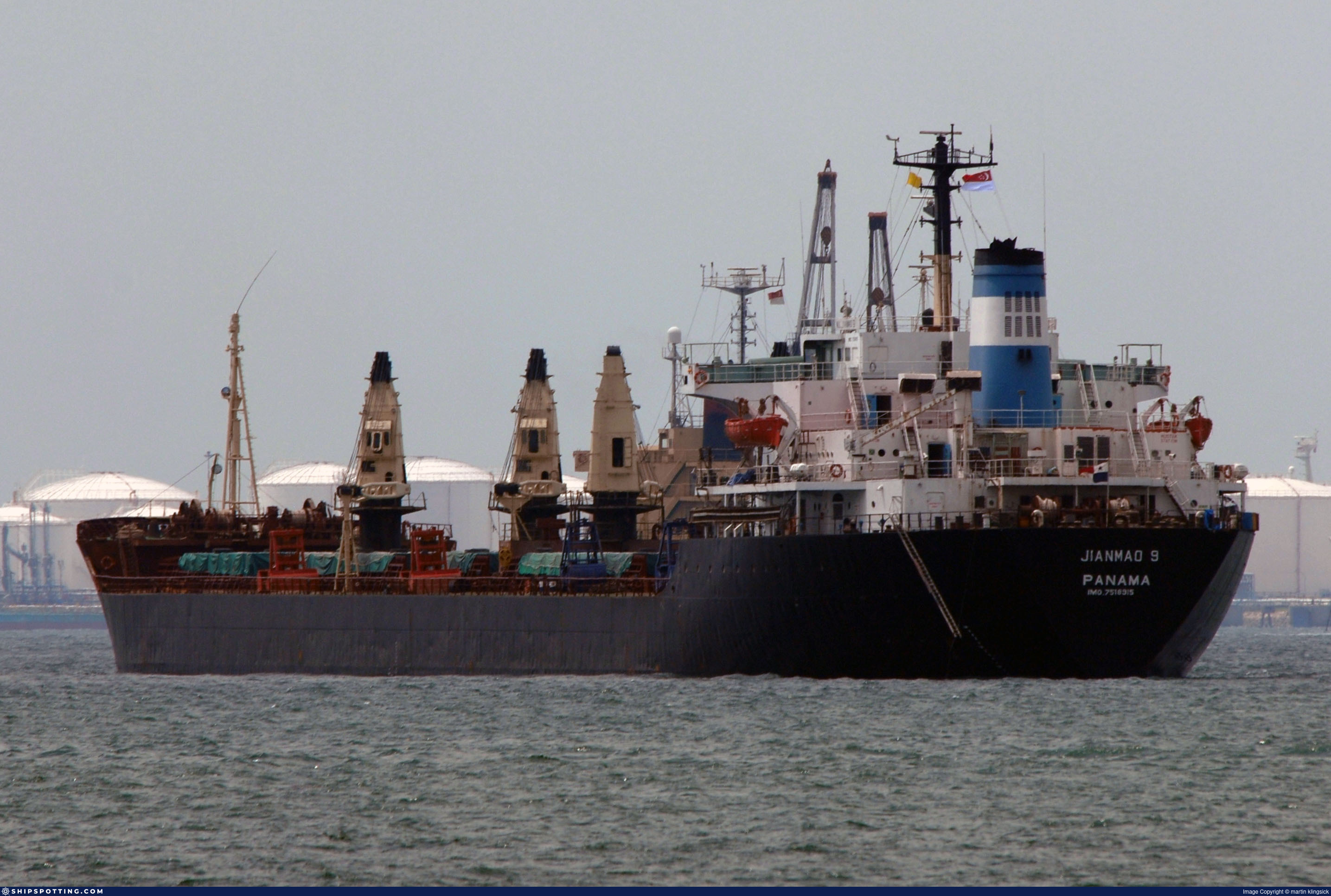
Pee-Wee says: Summit Venture was repaired and returned to service. She was sold several times over the years and sailed as Sailor, Sailor I, and finally Jianmao 9. On 9 November 2010 she sank in heavy seas off Vietnam. All 27 of her crew were rescued.

May 1980 was a rough month. The Sunshine Skyway story was big news…until nine days later when Mount St. Helens erupted.

Pee-Wee says: A beautiful, modern cable-stayed bridge was opened east of the original spans in April 1987. The new bridge’s design included large rock-filled concrete fenders and barrier islands–“dolphins”–protecting the support piers. In 2005 it was renamed the Bob Graham Sunshine Skyway Bridge in honor of the former governor and senator who first suggested the bridge’s design.


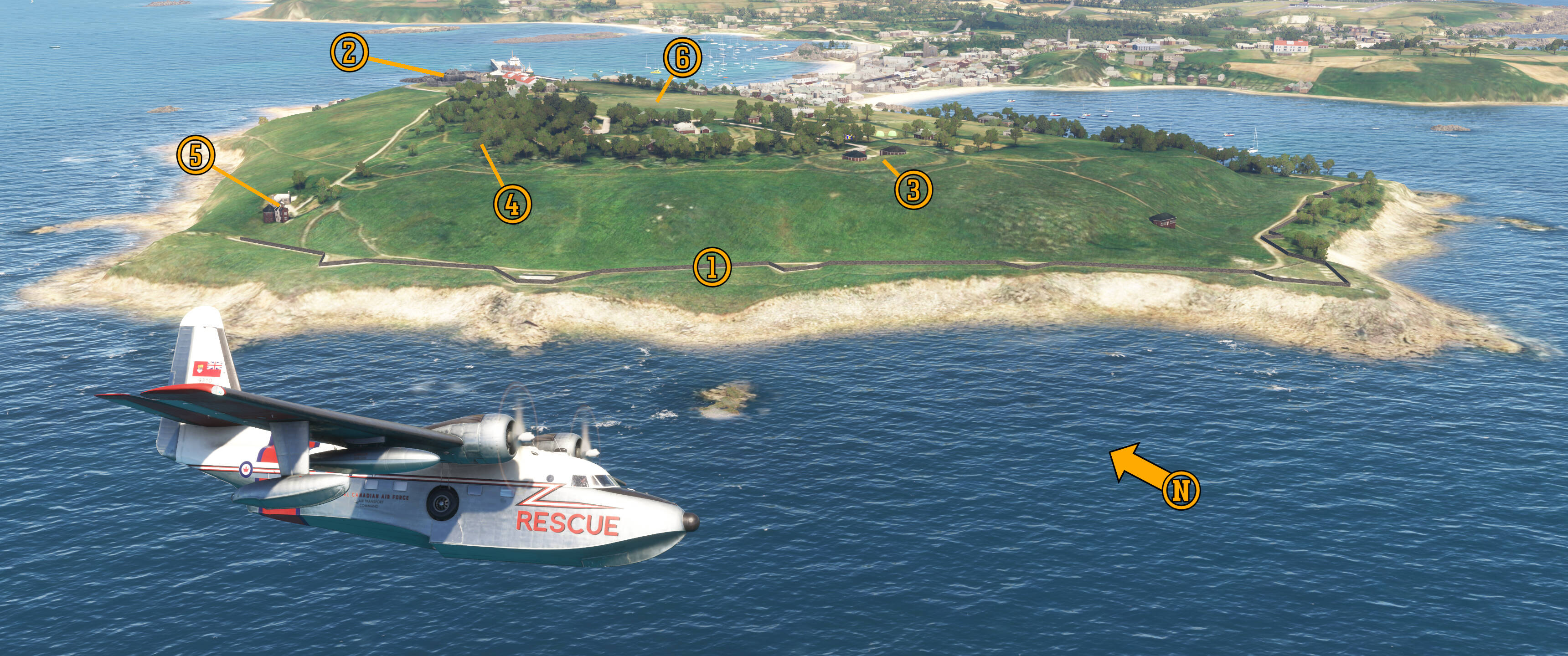
Here we are turning north around the new (1) Sunshine Skyway Bridge. The cable-stayed design was suggested after Governor Graham visited the Pont de Brotonne over the Seine in Normandy. The new bridge’s piers are protected by these (2) circular concrete buffers. The original spans were located almost directly behind our T-Bird.

Pee-Wee says: Portions of the (3) approaches to the original bridges remain intact and are used as fishing piers today. I’ve walked to the end of those piers in real life, and I have to say it was a little eerie knowing what happened here back in 1980. That’s (4) St. Petersburg in the distance.

By the way, this excellent Sunshine Skyway Bridge scenery was included in World Update #2*.*


:three: Chaos Isn’t Going to Like This: Peter O. Knight Airport (KTPF)

Approximately two miles south of downtown Tampa is the city’s first commercial airport, Peter O. Knight. The field was built in 1935 by the Works Progress Administration with three runways and a modern passenger terminal overlooking a seaplane basin. National Airlines was the sole commercial passenger airline here until Eddie Rickenbacker’s Eastern Air Lines arrived in 1937, the former operating Lockheed 10 twins along its “Buccaneer Route” from Miami to Jacksonville, and the latter operating Douglas DC-2s to Atlanta via Tallahassee.

By the end of World War 2, TPF was growing increasingly unsuitable for operations by larger aircraft, as highlighted by the non-fatal crash of a National Lockheed 18 in September 1945. A few months later, Eastern and National relocated to the former Drew Army Airfield across town.

Pee-Wee says: National’s NC33349 was built as a C-60A for the USAAF and converted to a Model 18-50 in 1945. While landing here on 13 September 1945, the aircraft overran the rain-soaked runway and stopped in the water beyond. All 14 passengers and crew survived, but 349 was written off.

Today, TPF is a vibrant general aviation airport with upwards of 60,000 aircraft operations annually. In 2012, it briefly gained national attention because of one spectacular unplanned operation.

Pee-Wee says: On 20 July 2012, an Air Force C-17A arriving from Rome, Italy landed on Peter O. Knight’s Runway 22. It was a textbook landing, albeit at the wrong airport! The aircraft’s intended destination was MacDill Air Force Base, approximately six miles to the southwest.

The crew realized their error after touchdown and maximized the Globemaster’s stopping capabilities to keep her on the paved runway. A video of the landing is available on YouTube, and if you watch the aircraft’s deceleration carefully, you’ll see the exact moment when the pilots said “oh, s##t!”

A replacement crew used the aircraft’s reverse thrust to back down the runway again, and several hours after the incident, the empty aircraft was flown to MacDill without incident.

The Air Force investigation blamed crew fatigue. After days of flying across multiple time zones with minimal rest, constant changes of destination and departure times, and 10.5 hours of flying which included a difficult air-to-air refueling, the crew was reportedly operating with a capacity only slightly better than being drunk.

Additionally, while the crew was aware of the proximity of TPF to MacDill and the similar runway alignments, they didn’t know that Tampa Executive Airport, located about six miles northeast of TPF, also had a similar runway arrangement. Having erroneously identified Executive as TPF, they assumed the next airport to come into view would be MacDill. If you’ve ever flown while fatigued, you’ll understand the danger of “expectation bias!”

Thankfully, the only damage sustained in the incident was to the pilot’s egos. Their passenger, General James “CHAOS” Mattis, was quite forgiving of his pilots, acknowledging the many hundreds of errors he made in his career. (I’ve flown with guys who know the pilots, and they have confirmed that the crew was lightly disciplined and continued to fly.)

Pee-Wee says: At the time of the incident, C-17A 08-8199 was assigned to the 305th Air Mobility Wing at McGuire AFB, New Jersey. Two years later, she’d migrated to the 62nd/446th Air Wing at McChord AFB, Washington. On 18 October 2020 she was damaged while landing with her nose landing gear retracted at Kandahar AB, Afghanistan.

Want a model of this notorious aircraft? GeminiJets’ 1:400 scale model isn’t available for direct purchase anymore, but you can find it occasionally at other online stores like this one or Ebay.


Pee-Wee says: Here we are diving toward Tampa proper, looking west. Here’s (1) Peter O. Knight’s Runway 4/22, the longest on the field at 3,583 feet (1,092 meters). Notice how (2) MacDill’s Runway 4/22 is almost in line with TPF’s runway and also located on a peninsula with houses to the north. Whoopsie!

TPF’s original passenger terminal stood on the airport’s south side (3) here. It was razed in the 1960s and replaced by the current building which today houses fixed-base operator Atlas Aviation. This (4) boat ramp off Severn Avenue is the old seaplane ramp into the anchorage. Across Tampa Bay you can barely make out the (5) Sunshine Skyway and (6) Albert Whitted and Al Lang Field.

Next, we’ll follow the (7) Seddon Channel north toward our next stop. We’ve gotta’ get down, though.

Pee-Wee says: I’m workin’ on it. Sheesh. Back seat driver. :roll_eyes:


:four: The Victory of Cigar City: The American Victory Ship & Museum

Two miles north of Peter O. Knight is Tampa’s Channelside District, a one-time industrial area that is one of the hottest addresses in town today. Here you’ll find high class condominiums and townhomes, shops and restaurants, the Florida Aquarium, and the Tampa Bay Lightning’s Benchmark Arena. Looking to buy? The median home here costs approximately $660,000 (€572,000). Bring your piggy bank!

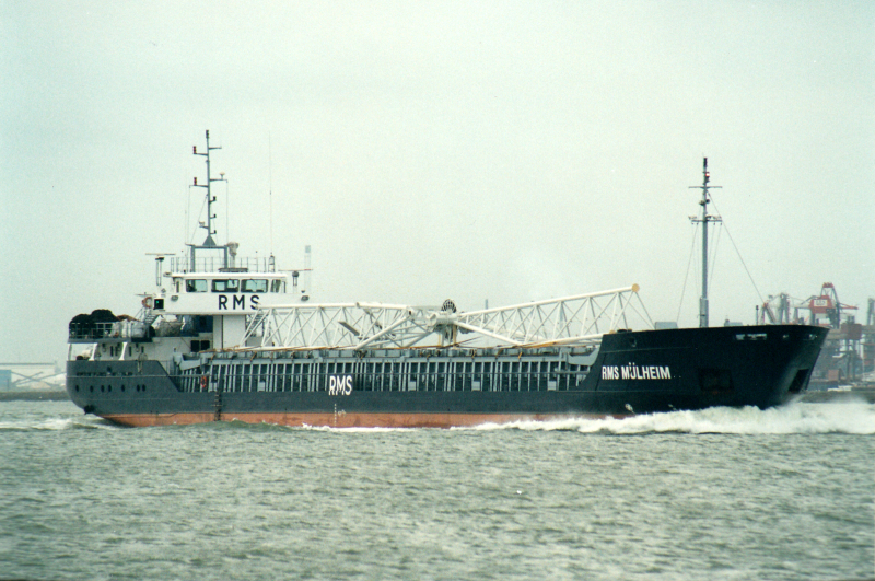
Pee-Wee says: That’s all well and good, but if you ask me, the real draw here is the American Victory Ship and Museum. The United States’ Emergency Shipbuilding Program built nearly 6,000 merchant ships of various kinds during World War 2, most notably 2,755 Liberty ships. Equally important if less numerous were the later Victory ships. The Victories were faster and more modern than their mass-produced cousins, and many of those that survived the war served for decades in merchant fleets worldwide.

American Victory was one of 69 VC2-S-AP2s built at California Shipbuilding south of Los Angeles, the same yard that produced the ill-fated Benjamin R. Curtis Liberty ship. (If you’ve read our Houston tour, that name should be familiar. Kaboom! :grimacing:) Delivered in June 1945, American Victory toiled throughout the Pacific Theater during the war’s final months and brought American men and equipment home afterwards. She was reactivated for the Korean and Vietnam Wars but finally mothballed for good with the James River Reserve Fleet in 1969.

“What on Earth is a VC2-S-AP2” you ask? Well…

V means “Victory type”
C means “cargo”
2 refers to the ship’s waterline length, in this case 400 and 450 feet (122 to 137 meters)
S means “steam-powered”
AP2 refers to the design variant, in this case a 6,000 hp general cargo ship. Other types included the AP3 with 8,500 horsepower, a single M-AP4 with diesel machinery, the AP5 assault transport, and the postwar AP7. The basic AP1 was unbuilt.

Now you know. :blush:

Tampa Bay harbor pilot Captain John Timmel and Victory Ship, Inc. saved American Victory from scrapping and brought her to Port Tampa Bay in the late 1990s. She’s fully restored and operational, and even sails around Tampa Bay occasionally, making her one of very few museums capable of moving under its own power! American Victory is open Tuesday through Sunday from 10 a.m. to 5 p.m., but opens two hours later on Mondays. Fifteen dollars grants you access to all of the ship’s restored public areas.

Pee-Wee says: We’ve visited American Victory, and you should, too! :+1:


Pee-Wee says: There’s a lot to see in this west-facing photo! Here’s American Victory nestled between Cruise Terminal 2 and Carnival Legend and Terminal 3 and Norwegian Dawn. Terminal 6 is vacant in MSFS, but you can see several floating drydocks and barges at International Ship Repair to the north.

Right next door is the (5) Florida Aquarium, an amazing aquarium and one of the world’s leading coral research and rehabilitation laboratories. Try to avoid school days, though: nearly 100,000 school children visit the aquarium every year.

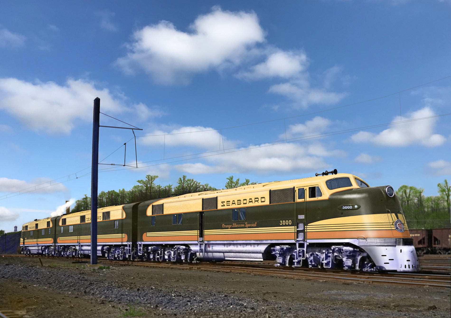
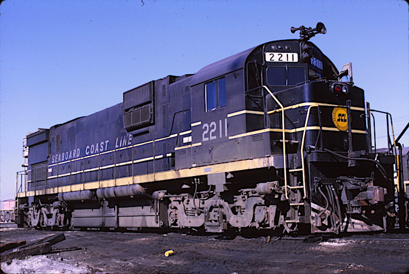
Pee-Wee says: Between the Selmon Expressway and Interstate 275 is Amtrak’s beautifully restored (6) Tampa Union Station. Built in 1912, the station’s eight tracks once hosted passenger trains like Seaboard’s New York–Miami Silver Meteor, Atlantic Coast’s competing Champion, and other less glamorous offerings like SAL’s Palmland and ACL’s Southwind. Today, the station sees only Amtrak’s Floridian, a recent mashup of the Capitol Limited and the Silver Star.

Hey, you’re a fan of Florida’s classic railroads. Seaboard or ACL?

Pee-Wee says: Seaboard, all day. The Orange Blossom Special’s E4As were things of beauty, and any railroad that operated such an assortment of diesels–EMDs, GE, Baldwins, and even F-Ms–is okay in my book. I’m particularly fond of its C-420s, and the Seaboard Coast’s C630s. And I’ve always felt like the SAL was “friendlier” than the larger ACL. Just my opinion. :blush:

So, you like Alco Centuries.

Pee-Wee says: 251s, baby. :grinning_face:

Anyway, over here is the (7) Hillsborough River flowing 60 miles (97 kilometers) from its headwaters in the Green Swamp south to Tampa Bay. The river was apparently named in the late 18th Century for the 1st Earl of Hillsborough, Secretary of State for the Colonies.

Beyond the river is (8) Tampa International Airport, formerly Drew Army Airfield where bomber crews trained throughout the war. Drew became Tampa’s primary airport when Eastern and National moved here from Peter O. Knight after the war. With Trans Canada’s arrival in 1950, the airport was officially renamed Tampa International.

Even further in the distance are (9) the Howard Frankland Bridge and the (A) Courtney-Campbell Causeway. The Frankland connects Tampa with St. Petersburg and was subject to significant reconstruction over the last thirty years, much of the work designed to fix the bridge’s significant faults that earned it several unflattering nicknames. The Courtney Campbell connects Tampa with Clearwater and was the longest overwater fill project in the United States when it opened in 1934.

Pee-Wee says: Many people muck up both bridges’ names. The Frankland is often incorrectly referred to as Franklin Bridge, and the Courtney Campbell, named for St. Petersburg Representative Courtney W. Campbell, is sometimes written as Courtney-Campbell. :roll_eyes:


I think it’s fitting that we visited American Victory on this tour, considering the movie’s subject matter.

Why’s that?

Pee-Wee says: Strategic Air Command was at its heart an American propaganda film.

You think so?

Pee-Wee says: Uh…yeah! Heck, the main character is a baseball player and war hero who’s married to the daughter of a minister, and who flies with guys named “Ike,” “Rocky,” and “Sgt. Bible.” No wonder it makes me crave apple pie. 'Merica! :smirking_face:

I can’t disagree! Let’s get back to those filming locations. Our next stop is a few miles south of Downtown.


:five: Ready to Defend…And Pass Gas: MacDill Air Force Base (KMCF)

Pee-Wee says: We’re rounding Third?

Yes, we’re into the home stretch. In the second half of Strategic Air Command our protagonist is promoted to full “bird” Colonel and transferred to MacDill Air Force Base in Tampa as the Deputy Wing Commander of the 305th Bombardment Wing. He and Sally return to their original home, and life is good.

Pee-Wee says: Until Dutch bins his flying career and almost ends his marriage in one fell swoop.

Well, kind of…yeah.

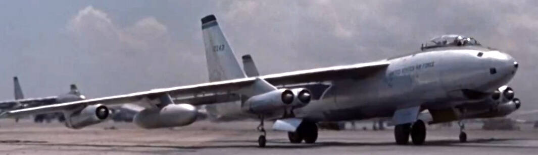
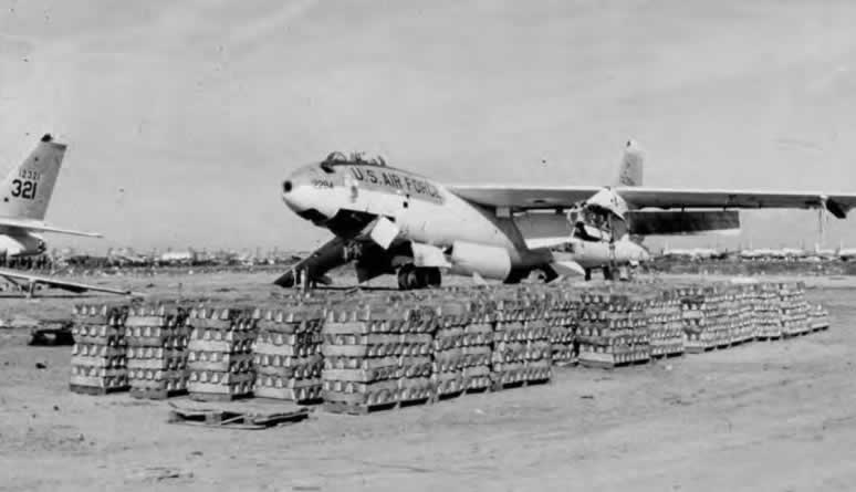
Pee-Wee says: Construction of Southeast Air Base on Catfish Point began on 28 November 1939, two days before the War Department announced the base’s renaming in honor of Army Colonel Leslie MacDill, a vocal proponent of Army aviation during the formative interwar years. The 29th Bomb Group’s B-17s and B-18s arrived here on 17 January 1941 and began patrolling the country’s eastern seaboard twenty-one days later, two months before the base’s official dedication.

MacDill hosted a B-17 replacement unit until June 1942 when training shifted to the new B-26 medium bomber.

Pee-Wee says: Martin’s first Marauders were tricky beasts. Their finicky electric propellers were susceptible to runaways, their nose landing gear were prone to failing, and their wings were too small. Inexperienced pilots found the aircraft unlike anything they’d flown before: a medium bomber that felt like a fighter, that was seriously unforgiving near the edges of its flight envelope, and which howled down final approach at a blistering 140 mph (121 knots, 225 kph).

A heavy B-26 landing with one engine inoperative approached at 155 mph (134 knots, 250 kph). For reference, that’s similar to a 737-700’s approach speed near maximum landing weight. For pilots whose “heavy” experience was limited to Curtiss AT-9s or Beech AT-10s, that was “hauling a#s!”

Pee-Wee says: Accidents were plentiful, and the exaggerated phrase “one a day in Tampa Bay” was mumbled often by pilots flying the “Widowmaker.” Some records indicate that in one month alone, twenty-one aircraft were lost. A review of accident reports is telling: in most cases, the pilots of crashed aircraft were two low time 2nd Lieutenants.

MacDill remained a “bomber base” for another seventeen years after the war until the Tactical Air Command took control, although SAC maintained an alert area complete with “mole hole” and dispersed B-52s and KC-135s here into the 1980s. During the Cuban Missile Crisis, the famed 363rd Tactical Reconnaissance Wing’s RF-101Cs and RB-66Cs flew low-level and electronic reconnaissance missions over and around Cuba from MacDill.

Pee-Wee says: But throughout the latter half of the 20th Century, the airbase remained a training field at heart, hosting F-4 and F-16 advanced training schools and the Air Force’s aircrew water survival school. Today, the 6th Aerial Refueling Wing’s KC-135Rs and the Central and Special Operations Commands call MacDill home.

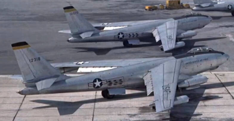
In the Spring of 1954, MacDill was home to the B-47s and KC-97Gs of the 305th and 306th Bombardment Wings (Medium), and aircraft from both appear in Strategic Air Command. Let’s take a look at those filming locations!


Pee-Wee says: Here we are looking down on MacDill from the east, just like the shot from the movie. Much of the filming was accomplished on the (1) east ramp in front of Hangars 3 and 5 where KC-135s park today. The first panning shot of MacDill in the film was taken from (2) the airfield control tower atop Hangar 1.

Also visible in this photo are the current (3) Florida National Guard and Navy Reserve facilities and the (4) munitions storage area. In the distance is the former (5) SAC mole hole and alert ramp. Compare the housing and recreation area in the bottom left of the photo to the smaller and more spartan accommodations seen in the film!

Pee-Wee says: Way over (6) here is Port Tampa, once the terminus of Henry Plant’s South Florida Railroad, the narrow-gauge line which finally connected Tampa Bay to the Atlantic Coast Line and the national rail network in 1893. It was from here that Col. Leonard Wood, Lt. Col. Theodore Roosevelt, and 590 of the “Rough Riders” sailed for Cuba and glory aboard SS Yucatan during the Spanish-American War.


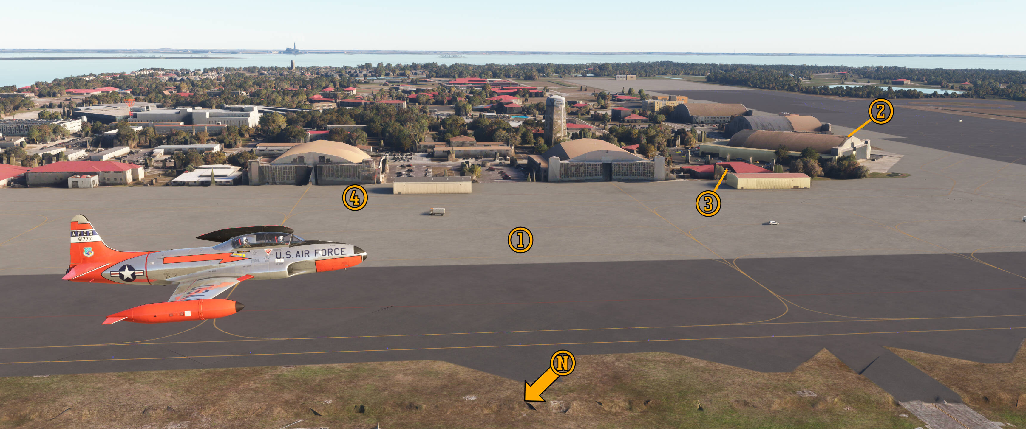
Pee-Wee says: Several scenes were filmed here on the (1) east ramp. The audience is introduced to MacDill with a long panning shot taken from the (2) former control tower atop Hangar 1. Look carefully between (3) Hangar 3 and the control tower and you’ll see the yellow (4) building which houses the 366th Bombardment Squadron’s offices. Later in the movie, after the Hollands quarrel, Dutch walks from this building before hopping aboard a pickup truck with his Japan-bound crew.

That’s the actual 366th Bomb Squadron’s sign on the building, complete with “winged skull” emblem! By the way, who do you suppose was the poor airman who was responsible for watering the sand? :laughing:

The producers of Strategic Air Command strove for realism and took few liberties, but when General Hawks’s C-97 stops at Wichita, that’s actually MacDill’s (4) Hangar 5 in the background. Note that sometime after 1954, MacDill’s hangars were renumbered. Hangar 5 is now Hangar 1, and 3 is now 2.


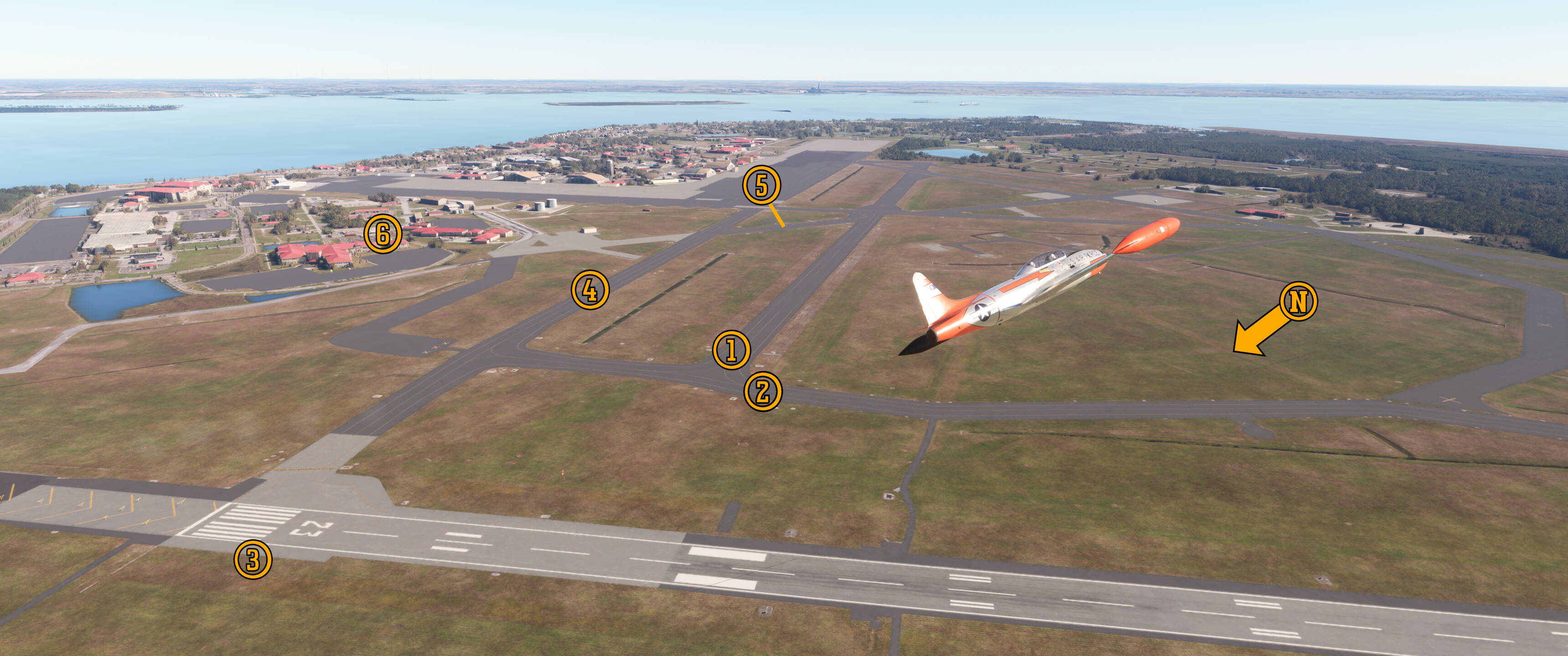
We’re looking southeast across the airfield in this photo. Dutch taxis his B-47 down the former (1) Runway 19 to this exact spot, where the (2) film crew was waiting. A few seconds later, Dutch taxis into position on (3) Runway 22. The runway certainly appears wide, and it was: in 1954, Runway 22 was an astonishing 500 feet (152 meters) wide! It’s since been reduced to a more normal 150 feet (46 meters), although you can still see the original width in the discolored grass.

Pee-Wee says: Watch carefully as the B-47 turns onto the runway and you’ll see the aircraft’s left outrigger gimble, something that only happened during tight turns. I’d never seen that happen before! We’ll talk about the takeoff scene and SAC’s willingness to disregard safety for the sake of filming later. :astonished_face:

KC-97s were parked (4) here along the former Runway 19’s parallel taxiway where today the (5) “bird bath” aircraft wash is located. This fresh-water spray rack removes corrosive saltwater spray from arriving aircraft. To the east is the contemporary (6) base clinic and recreation area, modern facilities that airmen stationed here in 1954 could only dream of!


That’s it for this tour, gang. I’ll bow out of the next part and let Pee-Wee gawk at the airplanes, but I’ll see you again in our next installment.

Pee-Wee says: Hey! You like the airplanes, too.

Yeah, but you really love digging up historical tidbits. I’m not saying it’s bad. It’s just what you do, and you’re really good at it.

Pee-Wee says: Nice save. :smirking_face: Thanks for tuning in, everyone! Stay tuned for the final part in which I’ll check out the 305th and 306th Bomb Wing’s B-47s, some KC-97s, and even a super-rare C-97 and early production Bonanza. Bye for now! :face_blowing_a_kiss:

Pee-Wee & Nag at the Movies

Strategic Air Command, Part 3


Pee-Wee says: I’ll dispense with the italics for now :blush:

Welcome back, everyone! Let’s look at the 305th and 306th Bombardment Wing’s B-47s. Here’s a quick explanation of their markings so you can identify individual aircraft and their units.

B-47’s carried their serial numbers on their tails. The first number is the second digit of the fiscal year in which the aircraft was ordered, and the numbers that follow are a sequential identifier. For example, B-47B 51-2318 was the 2,318th aircraft ordered during FY1951. Her serial number would appear on the tail as “12318.” Easy peesy!

Each of SAC’s B-47 bomb wings was composed of three bomb squadrons. Aircraft were marked with squadron patches on their noses and colored stripes on their tails corresponding to their assigned squadrons. Here’s the color assignments for MacDill in 1954:

305th Bombardment Wing (Medium)

Squadron Tail Color
364th Bombardment Squadron (M) Red
365th Bombardment Squadron (M) Yellow
366th Bombardment Squadron (M) Blue

306th Bombardment Wing (Medium)

Squadron Tail Color
367th Bombardment Squadron (M) Red
368th Bombardment Squadron (M) Yellow
369th Bombardment Squadron (M) Blue

I’m not going to talk about every airplane seen in the film, just the important or interesting ones. Most of the B-47s in the film were delivered to the Air Force, flew without incident for less than a decade, and went quietly to the scrapper. Good for their crews, boring for you readers!

Before I forget, all images below are copyrighted by Paramount Pictures and used here purely for educational purposes and not for profit blah blah blahbitty blah. :wink: Now, on to the planes!


“9065,” B-47B


Let’s start with this mysterious jet. She’s the first Stratojet we see in the film, supposedly parked inside Boeing’s hangar at Wichita, and she’s quite the enigma. She carries no squadron patch or tail stripe, and her serial number makes no sense. “9065” would equate to serial number 49-065, which was actually assigned to one of North American’s cancelled F-93 penetration fighters. She has a two-digit number–“33”-- painted ahead of her canopy, which doesn’t correlate to her serial number, and unlike the other aircraft in the film, she has pairs of yellow diagonal stripes painted atop her wings.

I considered that the Air Force changed her serial number for the film, and that she might be 50-0065, but that aircraft crashed in Florida on 3 July 1952, two years before filming began. Perhaps 51-2065? But why repaint that aircraft as “9065” anyway when every other B-47 in the film carries its real serial number?

Beats me. If anyone has any ideas, raise your hand. :wink:

By the way, 9065 is actually parked inside one of MacDill’s hangars. Dutch sure is lovestruck by her beautiful lines. I suppose he didn’t notice the others parked outside!


51-2318, B-47B


Here’s our first look at Dutch’s aircraft, B-47B 51-2318 assigned to the 365th Bomb Squadron, 305th Bomb Wing. She left Boeing’s Wichita factory on 30 September 1952 and was barely eighteen months old at her Hollywood debut. Her only claim to fame is starring in Strategic Air Command. Like most of her sisters, 2318 went quietly about her business until her retirement on 20 December 1960 while assigned to the 320th Bomb Wing at March AFB, California.

Want to build a model of this aircraft? Caracal Models produced a decal sheet for Hasegawa’s 1:72 scale B-47E. Yes, the sheet includes accurate “windows” and markings for a B-47B.

Here’s how to tell a B-47B from a B-47E:

B-47Bs have five windows on the left side of the nose for the bombardier, while the B-47Es have only the single upper window here, just like modified B-47Bs which have only one and early B-47Es which have five. Hold up…

Okay, B-47Bs had sliding canopies while B-47Es had clamshell canopies, except for early B-47Es that had sliding canopies. So…er…

B-47Bs had an internal ATO system while the B-47E used an external system, except for early B-47Es which also had the internal system and B-47Bs that had the internal system removed…ugh…

The B-47B didn’t carry external tanks while the B-47E always did, except that B-47Bs could also carry external tanks…son of a…

You know what? The first B-47E was 51-2357, so any bomber after that was an E. There you go. You’re welcome. :face_exhaling:

The movie’s producers were very good at maintaining aircraft continuity throughout the film but messed up their perfect record when Dutch’s B-47 magically transformed from 51-2318 to 51-2272 during the radar bombing run. Whoops!


51-2321, B-47B


Here’s General Espy’s 51-2321, theoretically assigned to the 366th Bomb Squadron, 305th Bomb Wing, taxiing for takeoff on the Wing’s historic deployment to Japan. Since both squadrons wore blue tail stripes and we never see her squadron patch, I can’t be certain she’s not assigned to the 369th Bomb Squadron, 306th Bomb Wing. This aircraft left the factory in October 1952 and joined the Air Force on 3 January 1953. She served until 1961 and appears during her final days on the far left edge of this historic photo.

Notice that her ATO ports are covered. Also, she isn’t toting external fuel tanks, an interesting operational choice in light of the distances involved to reach Japan non-stop!


51-2243, B-47B


Here’s the General’s wingman in B-47B 51-2243, one of only nine B-47Bs assembled by Lockheed from Boeing-supplied components. She was delivered to the Air Force on 6 August 1953 and retired in 1961.

Check out the consistency in this scene. When General Espy is sitting in the cockpit of his B-47, 2243 is to his left, and when he taxis away a few seconds later, 2243 really is sitting to his left!


51-2073, TB-47B


Hey, here’s Dutch’s 2318 again, ready to follow her sisters to Japan. That’s the 365th Bomb Squadron’s TB-47B 51-2073 in the background. Externally, she’s a run-of-the-mill early B-47B, with internal ATO, sliding canopy, original tail fairing with small radar blister, and J47-23 engines. Each “Dash 23” produced about 5,900 pounds (26,200 kN) of thrust for takeoff. That’s 35,400 pounds (157,200 kN) total, not much for an airplane with a maximum takeoff weight of 185,000 pounds (83,900 kgs)! The B-47E’s J47-25s produced an additional 1,000 pounds (4,400 kN) of thrust each, transforming the Stratojet’s takeoff performance from “terrifying” to “slightly worrisome!”

109 of the first B-47Bs were redesignated TB-47Bs in 1953 and were later modified further with additional seating for an instructor pilot and navigator, and removal of unnecessary systems like the aerial refueling receptacle, tail gun, and ATO.

2073’s delivery flight on 28 February 1952 got exciting when her #2 engine cowl separated in flight somewhere between Wichita and Tinker AFB. Her crew diverted to Tulsa, and after some quick repairs, she continued on her way. She had a short career, though, heading to Davis-Monthan AFB on 5 December 1958.


That’s it for the B-47s! Let’s take a look at some other airplanes that make brief appearances in the movie’s second half.


48-425, VC-97D and N2765V, Beech 35


I had to watch the transition to this scene several times in slow motion to make out this bare naked beauty’s serial number, but finally identified her as VC-97D 48-425, one of three C-97As converted to airborne command transports in the early 1950s. She was likely delivered in 1949 and was serving with MATS’s 1503rd Transport Wing at Haneda before conversion. Look carefully below the Aircraft Commander’s windscreen and you’ll see a “four star” flag. Could this have been General LeMay’s VC-97?

The VIP designation was short-lived and by 1956 the three sisters were redesignated C-97Ds. 48-415 suffered from irreparable corrosion and cracks in her wing spars and wound up on Barksdale AFB’s fire dump by 1960. Go to www.historicaerials.com and search for coordinates 32.49 -93.64953, then select the 1966 imagery to see this weary lady awaiting her fate.

This scene at “Wichita” was actually filmed outside MacDill’s Hangar #5. Notice the green car painted with “Boeing Aircraft Company Wichita” titles! But what better way to give the impression of a civilian field than adding a vintage Bonanza to the shot?

I enlisted help from some friends for this one, and we think that’s Model 35 Bonanza N2765V. There’s surprisingly little information about her online: she was built in 1947 and cancelled sometime before July 1964. Perhaps she was owned by a member of the film crew?


52-2613, KC-97G


Enroute to Japan, Dutch rendezvous with KC-97G 52-2613 just west of Mt. Baker in Washington State. (Be honest: how many of you thought that was Mt. Rainier? :wink:) This tanker was almost brand new in Spring 1954 and was probably still awaiting delivery when this scene was filmed, which would explain the lack of any unit markings.

Look carefully at Dutch’s B-47. Notice how the squadron patch and serial number appear to be surrounded by polished or scrubbed metal? It’s possible that the Air Force temporarily painted another Stratojet instead of flying the real 2318 all the way to Washington just for this shot. Perhaps an aircraft from the 9th Bomb Wing at Mountain Home AFB in Idaho, or the 22nd Bomb Wing at March AFB in California?

Here’a a fun tidbit you may not have noticed: just as the tanker’s boom disconnects, the B-47’s pilot switches on his windshield wiper. Fuel spraying onto the canopy was one downside of the B-47’s nose refueling receptacle! :open_mouth:


50-086, C124A


In the movie, several examples of Douglas’s “Ol’ Shaky” carried the Wing’s ground crews, spares, and equipment to Japan. Those aircraft were apparently assigned to the 1703rd Air Transport Group, part of the MATS Continental Air Division’s 1701st Air Transport Wing based at Brookley AFB near Mobile. The 1703rd ATG was notable for being one of very few units to operate Douglas’s C-74 Globemaster, and for being the first unit to receive both the C-124A and C.

The long, panning shot of 50-086 loading is interesting because it shows (1) the original cabin heater vents, (2) main deck troop door introduced after the first fourteen aircraft, and (3) the ventral cargo elevator in operation. Later C-124As and all Cs were equipped with more effective combustion heaters contained in aerodynamic wingtip pods. (Be honest again: how many of you thought those were fuel tanks? :smirking_face:)

50-086 was destroyed on 24 June 1967 when she stalled and crashed while landing at Whiteman AFB, thankfully without loss to her crew or passengers.

Who doesn’t love (4) the 305th’s four-legged friend roaming the ramp in the background? I wonder if he went to Japan, too. :blush:


Now we really are into the final stretch! Nag is going to rejoin here and provide insight from someone who flies large turbine aircraft. If you’re not interested in “detailed flying stuff and technical mumbo-jumbo,” feel free to skip to the end. :wink:


Pee-Wee says: Let’s start with that awesome rocket-assisted takeoff.

For their maximum takeoff weight, all B-47s–but especially the B-models–were criminally underpowered. In the early 1950s, jet engine technology was still developing, and compact, powerful turbojet engines were still years away when Boeing conceived the Stratojet. To compensate for the J47’s limited thrust, Boeing’s engineers designed an Assisted Takeoff (ATO) system that used eighteen Aerojet 14AS-1000 rockets mounted inside the fuselage behind the wings. The system was intended to reduce the aircraft’s takeoff run–not improve its climb performance–and was normally “fired” 10 seconds prior to lift off.

Pee-Wee says: The first number in Aerojet ATO rocket designations is the duration of burn in seconds. The second number is the thrust produced. The 14AS-1000 produced 1,000 pounds (4,400 kN) of thrust for 14 seconds. The B-47B’s fully loaded ATO system produced 18,000 pounds (79,200 kN) of thrust while the B-47E’s 33-bottle external ATO “horse rack” produced a whopping 33,000 pounds (145,200 kN), nearly doubling the aircraft’s dry thrust!


Now let’s look at the movie scene. Notice anything unusual?

Pee-Wee says: The aft gear is already off the ground?

Exactly. The B-47’s takeoff performance was planned down to the knot, and pilots would simply allow the aircraft to “fly off” the ground with very little elevator input. “Holding” the aircraft on the runway like this was frowned upon.

Pee-Wee says: I can see why. Since the forward gear was steerable, wouldn’t that be like balancing on a high-speed unicycle?

Yes. Also notice that, although the aircraft has obviously accelerated past its normal takeoff speed, the ATO only fires when the aircraft leaves the ground. From reading several B-47 flight manuals, I learned that the ATO system activated either when the pilot pressed the firing switch on the throttles or when the landing gear “squat switches” shifted to “flight” at liftoff.

It appears that not only did this pilot hold the aircraft on the ground beyond the normal takeoff speed, but he delayed activation of the ATO and possibly relied on the squat switches for the firing signal. From what I read, both were considered poor technique.

Pee-Wee says: But it sure was impressive on film, and I’m sure that was the goal. That additional 18,000 pounds of thrust during climbout certainly made the airplane appear to the audience more powerful than it really was!

Exactly. I’m not saying the pilot messed up, but that this takeoff was rigged for maximum cinematic effect. Now, here’s another example.


The camera for this shot was mounted in the bomb bay. Notice the right bomb bay door peeking into the frame. There was no published procedure–normal or emergency–for landing with the bomb bay doors open, but it certainly wasn’t a normal procedure.

To prevent buffeting, the B-47 was equipped with three hydraulically actuated spoilers just behind the forward landing gear that would extend automatically whenever the bomb bay doors were opened in flight. In the landing view from the film, those spoilers should be open, but they aren’t. Look carefully in the very top of the frame and you’ll see the closed spoilers. Apparently, they were deactivated for this shot, as they would have partially blocked the camera’s view of the runway.

Pee-Wee says: So, for the sake of dramatic footage, the Air Force allowed some procedural changes that perhaps weren’t the safest?

That sure seems to be the case.

Pee-Wee says: Boy, times sure have changed, haven’t they? I doubt movie producers would get that much help from the military today!


Well, this wound up being a much longer tour than initially planned.

Pee-Wee says: We say that every time. Maybe we should choose more manageable subjects in the future.

I have a few ideas already.

Pee-Wee says: Ooh. I can’t wait. Let’s wrap this one up first.


Pee-Wee says: That’s $139 million dollars, 9 airplanes, 27 airmen, 54 jet engines, 19,500 gallons of fuel an hour, and 68 megatons of striking power.

Back when Boeing could build a decent airplane.

Pee-Wee says: Dang. That was harsh.

But deserved.

Pee-Wee says: Tell me about the MCAS again? :face_with_peeking_eye:

Hah! Later.

Thanks for tuning in, everyone! Keep the feedback coming, and remember to always make backups and floss before bed. We’ll see you again soon!

Pee-Wee says: Bye for now! :blush:

A Special Note from Pee-Wee and Nag


Pee-Wee says: Whew. That last one was a hard nut to crack, wasn’t it?

But you had fun, right?

Pee-Wee says: Watching one of my favorite movies and then reading and writing about airplanes, geography, and history with my favorite person in the whole wide world? Heck yeah, I had a great time! :heart:

That’s good to hear.

Pee-Wee says: So, why are we back so soon?

Well, I was curious about our body of work, so I did some tabulating this morning, and I think you and our readers will find the results interesting.

Pee-Wee says: You’re from the down south. Don’t you “do some figerin’?”

Very funny. At least I don’t sound like a leprechaun.

Pee-Wee says: Hey, that only happens when I’m really tired or really angry, thank you very much.

Anyway, the numbers are staggering. Since March 2024, we’ve published 20 Skytours in 55 individual entries, for a total word count approaching 116,000.

Pee-Wee says: I’m no publisher, but that sounds like a lot.

It’s roughly equal to Ernie Gann’s Fate is the Hunter and Jane Austin’s Pride and Prejudice, and longer than Mark Twain’s The Adventures of Huckleberry Finn and the first two Harry Potter books. At this rate, we’ll equal the length of Tom Clancy’s Red Storm Rising in two years and Tolstoy’s War and Peace in April 2032.

Pee-Wee says: 2032, you say? Wasn’t MSFS2020 advertised as a 10-year application?

Yes.

Pee-Wee says: We need to type faster.

We’ve averaged one 5,800-word writeup every month, toured four countries and nine of the fifty United States, and logged enough virtual miles to circle the Earth. And we’ve done all that without collecting a single dime from anyone.

Pee-Wee says: Well, aren’t we awesome. :smirking_face:

We never expected this to become anything more than a few essays, but here we are, still going strong after almost two years, and that’s thanks to our readers who continue to explore with us. We see the “view count” and know you’re there, and we appreciate it.

Pee-Wee says: And here’s a huge “thank you” to those who’ve taken the time to give valuable feedback and heartfelt encouragement. :blush:

That’s all. I just thought you’d all be interested.

Pee-Wee says: You’re not getting tired of this, are you?

Not even close. In fact, I already have an idea for our next tour.

Pee-Wee says: Yay!

Realistically, everyone, expect a pause for the holidays. We’ll be back soon enough. Thanks again for tuning in, and if time gets away from us, we wish you all a wonderful holiday season!

Pee-Wee says: Bye for now! :face_blowing_a_kiss:

1 Like

Pee-Wee’s Little Adventure #2

The Flight of the Ancient Mariner, Part 1


Welcome back and Happy New Year, everyone! The weather across the States was uncooperative around the holidays, so Nag is exhausted and not in the mood to write or explore…or anything involving airplanes, really! Looks like it’s time for another Pee-Wee’s Little Adventure! :blush:

Today I’m heading to Land’s End on the tip of Cornwall, then across a mythical land from Arthurian legend to the nearby Isles of Scilly (pronounced “Aisles of Silly,” which sounds like a really awesome shopping experience). I’ve visited all three places in real life but never in MSFS because there was something missing. Well, that something showed up a few days ago:


Microsoft’s HU-16E Albatross, courtesy of the Marketplace’s holiday sale. The Albatross came highly recommended by a trusted online friend, and I’m happy to say that I still trust him! Microsoft did right by the big Grumman: she’s the work of Mike Johnson (a.k.a. Lotus and @Ramasurinen), the famed creator who brought us the amazing Lotus Simulations L-39 for FSX. As expected with such talent at the helm, she looks and flies great, and everything works as it should.

The Royal Canadian Air Force operated ten “long wing” HU-16Bs with more powerful R-1820-82 engines and a snow ski concealed in their keels. Known locally as CSR-110s, they were the first purpose-built search-and-rescue aircraft purchased by Canada. This is serial number 9310 as she appeared shortly after delivery to 111 Communications and Transport Unit (111 KU). She went on to serve the Fuerza Aérea de Chile and the Royal Malaysian Air Force and was displayed at Ipoh Air Base until the early 2000s when she was apparently scrapped.

The Pisces in me loves a good flying boat, and this one’s a keeper. Fast, easy-handling, and designed for the open ocean, she’s the perfect mount for today’s maritime-themed tour. I highly recommend flying a seaplane or amphibian: some of the sites are best viewed from the water!

MSFS’s base scenery for the Isles of Scilly is nothing to write home about, but there are some third party addons available. My fellow 2020 users have two options: SuperSpud’s and the more recent offering from RealVFR. SuperSpud’s is the more complete package. RealVFR’s looks very nice but conflicts with Orbx’s Great Britain South. I went back and forth several times but finally settled on SuperSpud’s scenery for this tour. (Remember to install the complimentary scenery packages listed on the download page, like mgk07’s Isles of Scilly Shorelines.)

For my brave 2024 users, the only choice is the RealVFR package. Good news: SuperSpud’s excellent Land’s End Airport is compatible with both sims!

How about some waypoints?

Waypoint LatLong Skyvector
Land’s End Airport EGHC
Cape Cornwall 50.1275 -5.7071 500739N0054225W
Sennen Cove 50.0862 -5.6940 500510N0054139W
MV RMS Mülheim 50.0734 -5.7084 500424N0054230W
Land’s End 50.0691 -5.7167 500409N0054300W
Wolf Rock Light 49.9453 -5.8064 495643N0054823W


The winds at Land’s End favored 2,572-foot (784-meter) Runway 34, a narrow strip of rolling asphalt aimed toward St. Just and the Cot Valley. Yes, the runway has some ups and downs but wait until you see St. Mary’s! Takeoff was a fingers-crossed affair: this was one of my first flights in the Albatross and I was only reasonably certain the runway was long enough for two people, a dog, some bags, and 680 gallons of gas! (Spoiler alert: it was.)

Flying started at Land’s End in September 1937 when Channel Air Ferries began once-daily service from here to the golf course on St. Mary’s in the Scillies. The airline’s Dragon Rapide lived in a hangar brought 400 miles (643 kilometers) from Squires Gate Airport in Blackpool until former Aer Lingus Dragon G-ACPY arrived in 1938 when the service was taken over by Great Western & Southern Airlines. Quite controversially, ACPY was shot down by a passing Luftwaffe He-111 on 3 June 1941. The pilot and five passengers—a vacationing husband and wife, their two children, and mother-in-law—were killed.

BEA took control in 1947, and its trusty Dragon Rapides remained on until May 1964 when they were replaced by Sikorsky S-61N helicopters flying from the Penzance Heliport seven miles (11 kilometers) to the east. Fixed-wing service returned with Scillonia Airways but was gone again by 1969. Another fifteen years passed before Skybus began serving the Isles with Islanders and Twin Otters. Today both the airport and Skybus are owned by the Isles of Scilly Steamship Company.

Scillonia’s Dragon Rapide G-AHAG still flies from Membury, beautifully restored in the airline’s pleasing white and turquoise colors.

Enough chatting. Let’s get going!


:one: So Many Acronyms: Cape Cornwall

Right after takeoff you’ll see St. Just ahead and the Cot Valley dropping toward the Celtic Sea. The valley’s mild microclimate attracts several types of large birds including buzzards and Cornish choughs (pronounced “chuffs”), and seals are routinely seen sunning on the shore beneath the valley’s mouth. I flew a wide teardrop course reversal to the northwest and followed the rugged sea cliffs southbound. Stay low: if you’re flying above 500 feet (150 meters), you’re probably missing something!


That’s Cape Cornwall down there, where the Celtic Sea meets the English Channel. Atop the rocky headland is (1) The Stack, part of the abandoned Cape Cornwall Mine. Cornwall may be a beautiful tourist destination today, but in the late Nineteenth Century it was a mining powerhouse, producing copper, lead, and nearly two-thirds of the world’s tin. At the height of the Industrial Revolution, twenty-five percent of Cornwall’s population worked the mines, the remains of which are visible up and down the coast today.

In 1987, the Heinz Company (maker of Great Britain’s most famous snack food) purchased Cape Cornwall and donated the land to the National Trust. Today, this area is part of the Cornwall Area of Outstanding Natural Beauty (AONB).

Yes, that’s an official designation! Many locales in the United Kingdom are designated Areas of Outstanding Natural Beauty (AONB), Biological or Geological Sites of Special Scientific Interest (SSSI), Areas of Archaeological Importance (AAI), and Regionally Important Geological Sites (RIGS). The tip of Cornwall is part of the Cornwall AONB and the Aire Point to Carrick Du SSSI. We’ll visit the Isles of Scilly AONB later.

South of the Cape is (2) Priest’s Cove, famous for having nothing to do with priests but for attracting brave swimmers who race annually from the nearby Brisons back to the beach here.

Cornwall isn’t just abandoned mines. All along the coast are heritage sites like (3) St. Helens Oratory, a pre-Reformation church and prayer oratory standing on the grassy slope overlooking (4) Porthledden. The chapel’s original cross was apparently taken to St. Just and later tossed down the vicarage’s well. (Why, nobody knows.) The current cross was found nearby and placed atop the southern gable.

The abandoned (5) Boswedden tin and arsenic mine lies near the mouth of the Kenidjack Valley. Powered by the Tregeseal River, the mine’s 65-foot (20-meter) water wheel was once the largest in Cornwall.

Atop the headland to the north is (6) Kenidjack Castle, one of eighteen Iron Age “cliff castles” carved from the underlying granite along the Cornish coast. They were evidently occupied until the Roman Era and in some cases even later, although their exact purpose remains a mystery. During World War 1, Kenidjack was used as a rifle range by the local militia.

Way off in the distance is the smokestack from the short-lived Allens Shaft Botallack Mine. Sinking of the main shaft began in about 1906, but like many tin mines along the this coast, the main lodes were located out of reach offshore, and mining ended here in 1914. An abortive attempt to revive the mine and reach the inaccessible deposits in the 1980s ended when the International Tin Council failed and global tin prices collapsed. The main shaft sinks about 1,400 feet (426 meters) below ground, one of the deepest mines in Cornwall.

Many Cornish miners left for greener shores when the mining industry began its long decline, with thousands taking their skills to the booming mines in the United States, Australia, and South Africa. Between 1861 and 1901, nearly one-fifth of Cornwall’s men emigrated overseas each decade! An estimated six million people worldwide—2.5 million in the United States alone—are descended from Cornish immigrant miners.


:two: Not for the Faint of Heart…or Visitors: Gwynver and Sennen Beaches

Cornwall is a maritime county, bordered on three sides by the Celtic Sea, Bristol Channel, and English Channel, with about 430 miles of coastline. The National Maritime Museum, Cornwall is located at Falmouth harbor and features not only historic Cornish boats but hundreds of small watercraft from around the world.

Cornwall’s commercial fishing industry is thriving, but not because of national interest. Nearly 80% of the county’s catch is exported to mainland Europe, and especially to France where cheaper Cornish shellfish are highly prized.

Millions of holidaymakers swarm Cornwall’s white sandy beaches and rugged coastline annually, contributing upwards of 15% to the county’s economy. Cornwall is also the epicenter of the UK’s thriving surfing community. All along the county’s north shore and continuing on to Scotland, you’ll find beaches with consistent waves driven by the powerful Atlantic swell. Every year, thousands of people flock to Newquay for the Boardmasters surf competition and music festival and Surf England’s English National Surfing Competition at Fistral Beach and Watergate Bay below RAF St. Mawgan/Newquay Airport.

If you plan on joining the lineup here, bring your wetsuit: the average water temperature is a chilly 62°F (17°C) in the peak summer months, but plunges to an absolutely bone chilling 50°F (10°C) in winter. :cold_face: I love surfing, but when it’s that cold, you’ll find me back at the lodge, sitting in front of the inglenook, wrapped up to my eyeballs in my favorite quilt and nursing a hot cocoa!


I’m passing abeam (1) Land’s End Airport in this northeast-facing photo. Cornwall boasts more than three hundred beaches, and here inside Sennen Cove are (2) Gwynver and (3) Sennen Beaches. Separated only by a slight rock outcrop, these two beaches may as well be on different continents! At Sennes you’ll find consistent waves for surfers at all experience levels, and several surfing schools operate from its beautiful white sands. The scene at Gwynver is completely different: exposed to the full brunt of the Atlantic swell, the waves here are much less forgiving and with the underlying sands shifting daily, a good run one day may be unrideable the next.

Also, like so many surf spots worldwide, Gwynver is, in my experience, cursed with a particularly unwelcoming group of locals. (If you’re ever here and meet the obnoxious stubby ork with the tie-dyed Hypto Krypto and a bloody nose, tell him he deserved it. :smirking_face:)

This is our first good look at the (4) South West Coast Path, Britain’s longest waymarked long-distance hiking trail. Built for Coastguardsmen to patrol for smugglers, the path meanders along the shores of Somerset, Devon, Cornwall, and Dorset for more than 600 miles (965 kilometers) from Minehead to Poole Harbour. I’ve hiked many miles of this wonderful trail, but never the whole length, which at my average pace would take about nine non-stop days. Gonna’ need some new sneakers. :blush:

Oh, and be careful near the terminus at Poole Harobour. The path crosses Studland Natural Beach. “Natural beach” is the English term for “clothing optional.” Yikes! :flushed_face:

Smuggling was another leading industry in Cornwall during the 18th and 19th Centuries, so much so that some historians estimate that more alcohol entered England illegally through the Cornish coast than approved channels in London! Cornwall was home to the likes of Zepheniah Job, the “Smuggler’s Banker” who, among his legal business activities, encouraged and bankrolled significant smuggling operations; John Carter, the honest “King of Prussia” who operated from Porthleah (now named Prussia Cove in his family’s honor); and “Cruel” Coppinger, a hulking Dane who shipwrecked here and decided to form his own gang of “free-traders.”

With so many ships foundering along the Cornish coast, wrecking—the illegal salvaging of cargo from sunken or grounded ships—was common. Smugglers earning their livings in this trade were dubbed “wreckers.”

Most of the (5) homes in the tiny hamlets of Escall and Mayon overlooking Sennen Cove are vacation rentals. Prices range from the high $100s (£75) for a nook beneath someone’s stairs to upwards of $500 (£370) per night for a two-bedroom affair in the shoulder season.

Our next site is just around the bend at Sennen Cove. You should probably slow down: it comes up quick and his hard to see! (Oh, by the way, it’s a shipwreck, but nobody got hurt and the story is pretty funny, so I won’t blur this section out. Read on!)


:three: Explain That to the Insurance Company: MV RMS Mülheim

The four-year-old German dry goods carrier RMS Mülheim was enroute from Cork, Ireland to Lübeck, Germany with a load of recycled automobile plastics when she ran aground south of Sennen Cove before sunrise on 22 March 2003. The crew of six was airlifted without injury from the stranded ship by a Sea King from nearby RNAS Culdrose, but the hapless freighter remained on the rocks until she finally broke apart.

“RMS” doesn’t mean Royal Mail Ship in this case. The Mülheim’s operator was Rhein-Maas-und See Schiffahrtskontor (RMS).

Prior to the grounding, the ship experienced no mechanical abnormalities, and the weather was quite agreeable. So, how did a perfectly good ship in perfectly good weather crash headfirst into Cornwall? The answer is simple:

Pants.

Investigators discovered that the single watch officer’s pants tangled in the master’s chair causing a fall that rendered him unconscious. When he came to, Mülheim was bearing down unavoidably on the rocky shore.

Yup…pants. (I can’t make this stuff up. :neutral_face:)

Over the next few weeks, the ship’s fuel and a significant portion of her cargo were salvaged. Declared a constructive loss, the ship was abandoned to her fate. During the week of 7 October, the ship’s bow separated and fell into the sea, and on the last day of the month, another storm smashed Mülheim’s battered remains deeper into Gamber Bay where she lies today.

In marine insurance, “constructive loss” means that the cost of repairing the insured vessel exceeds the insured value. In aviation, we say “damaged beyond repair.” Vessels that are physically lost (i.e. sunk) are considered “actual total losses.”

During the subsequent litigation, the ship’s owner was fined for not maintaining the required two-man watch during night hours. Twenty-two years after Mülheim ran aground, a large portion of the ship’s stern remains on Gamber Bay’s rocky shore and is visible from the South West Coast Path.


It’s also (1) visible in MSFS, beneath the (2) Maen cliff castle. Scenery developer mgk07 published a MSFS2020 watermask improvement package for Cornwall that makes the wreck easier to see, but unfortunately, it’s currently broken and creates a deep chasm behind the cliffs here.

:four: The 874 Mile Hike: Land’s End

Humans love extremities—the furthest this, the tallest that, the fastest whatsit—and so it is with geography. Projecting into the sea from the very tip of Cornwall, Land’s End is the westernmost point of mainland England, and whatever the season, it’s a breathtaking place. Standing atop the towering cliffs with all of England behind and nothing but open ocean ahead feels like standing at the bow of a great sailing ship, and like Jack and Rose, you’re the King of the World.

Just ignore the tourists with their souvenir shirts, “Land’s End” rocks, and Cornish pastys jockeying for the best selfie behind the tourist plaza. :face_exhaling:

For a more secluded experience, visit the UK’s other extremities, like Lizard Point, the southernmost point of mainland England just around the bend from Land’s End, or my favorite, Dunnet Head in Caithness, the northernmost point in mainland Great Britain.

Chicago businessman Gary Comer and his associates named their mail-order yachting supply and clothing company after Land’s End in Cornwall. Unfortunately, none of them noticed the misplaced apostrophe until after thousands of the company’s first catalogs were printed and ready for mailing. Unable to afford another printing, they leaned into the error, officially adopting the name Lands’ End!


Well, this looks…amazing. :unamused_face: MSFS has trouble with cliffs and promontories like buttes and spires, and there’s a boatload of trouble in this south-facing photo! The whole of Land’s End—officially Peal Point—is visible, including (1) Dr. Syntax’s Head, the westernmost point of mainland England.

The Tour of Dr. Syntax in Search of the Picturesque is an 1809 satirical poem written by British author, debtor, and general hack William Combe. The poem follows the misadventures of the eponymous clergyman and headmaster as he travels the Green and Pleasant Land in search of the “picturesque,” a play on the famous works of artist William Gilpin. Dr. Syntax is considered to be the world’s first real cartoon character.

A large rock here looks like Dr. Syntax’s head…if you squint just right! :blush: (Hint: in the linked photo, Syntax is looking down and to the right.)

Other formations nearby are (2) Goose Slade Point and (3) The Armed Knight, both of which are completely pancaked in MSFS. Here’s the (4) South West Coast Path again, winding its way toward (5) First and Last House. Believed to date from the early 19th Century, the building was used from 1860 by Ms. Gracie Thomas as the “First and Last Refreshment House in England” and souvenir stand. It’s been expanded since then and today’s souvenirs are probably made in China, but the First and Last House is still a place for a nice cuppa and a bowl of locally sourced ice cream.

Here’s the newer (6) West Country Shopping Village, Bakehouse, Experience Shop, and Land’s End Hotel. MSFS’s autogenerated buildings make this tourist trap look about as inviting as a super max prison, or perhaps post-meltdown Pripyat.


With Orbx’s GB South installed, you’ll see the famed “Lands End” marker overlooking Longships Rocks. The distances on the sign are mostly self-explanatory: 3,147 miles across the Atlantic to New York City, 28 miles to the Isles of Scilly, and 1.5 miles to Longships. But who is John o’ Groats and why do we care how far he is from Land’s End?

John o’ Groats is the village in County Caithness, Scotland, commonly recognized as the northeastern extremity of Great Britain. The road trip from Land’s End and John o’ Groats traverses 874 miles, the longest distance between extreme points of Great Britain. Yes, there’s a matching sign in John o’ Groats.

For comparison:

New York City to Milwaukee = 880 miles
Los Angeles to Boise = 841 miles
Paris to Rome = 885 miles
Berlin to Cherbourg = 831 miles

Longships Lighthouse should be visible on the distant rocks, but with SuperSpud’s Orbx-cooperative scenery installed, it’s absent, one of several compromises we must accept for adequate scenery in this area.

That’s it for mainland Cornwall! Our next point lies about eight miles southwest of Land’s End in the English Channel. The next thirty miles are over water, so any unplanned landing will result in getting your feet wet. Check your fluids (fuel, oil, bladder)!


:five: The Swamp King Would Be Proud: Wolf Rock Light

Rising sharply more than two hundred feet to the water’s surface eight miles southwest of Land’s End is notorious Wolf Rock, a Cretaceous volcanic mount unlike any other in Cornwall. Notorious is an inadequate adjective for this inhospitable crag, for littering the seabed here are the wrecks of hundreds if not thousands of sailing ships whose hulls were mangled and shredded by the Wolf’s phonolite teeth.

Atop the rock stands the Victorian era Wolf Rock Light. Completed in 1869, this 135-foot (41-meter) granite sentinel is at least the fourth marker built here, the others being short-lived “daymark” affairs that were swept away almost immediately by the raging Atlantic. Only the earlier conical metal daymark completed in 1848 remains today.

The rock is named for the sound it once made. For centuries, seawater pushed by the Atlantic swell forced air through a peculiar horn-shaped outcrop here, generating a distinctive howling sound reminiscent of a wolf’s call. Unfortunately, the opening was plugged by Cornish wreckers who realized that the sound—a natural warning for approaching ships—was sinking their profits!

The Wolf Rock Light holds a special place in aviation history: it’s the first lighthouse anywhere equipped with a helicopter landing pad atop its tower. Added in 1972, the pad is landable in MSFS.

For the military historians here, Wolf Rock boasts another claim to fame, being the only lighthouse credited with sinking a submarine! On 18 December 1944, the German U-1209 ran aground on Wolf Rock in broad daylight, supposedly during a heated “navigational disagreement” between the boat’s captain, who thought the submarine was west of Wolf Rock, and the navigator, who knew they were approaching it. Refloated by the waves, the mortally wounded submarine drifted to the east and was scuttled by her crew. Nine men, including the captain, were lost while the others were rescued by the Canadian destroyers Montreal and Ribble, and Royal Motor Lifeboat (RML) 542 from Newlyn.

Oh, for those of you wondering, the navigator was right. :wink:


No annotations this time. (If you can’t find the lighthouse in this photo, there’s nothing more I can do for you. :laughing:) The Wolf Rock Light appears quite worse for wear, but imagine how you’d look after suffering the North Atlantic’s fury for 157 years! Look carefully to the left of the tower and you’ll see the 1848 conical daymark, a nice detail included by SuperSpud. U-1209 apparently struck Wolf Rock while submerged, surfaced, and was pushed atop the rock before sliding back into the sea. Her wreck is located approximately one mile east of the lighthouse.

A keeper’s life on Wolf Rock was miserable isolation, and relief was often delayed for weeks by storms that kept small motor launches away. I’m certain the “all-weather” helicopter pad was a welcome addition! Automation came in 1988 and today the Wolf’s only visitors are mechanics and seagulls.

Did you understand my Swamp King reference? If so, respond here and receive thy laurels! :slightly_smiling_face:


Gosh, I guess this isn’t going to be such a little adventure after all! This seems like a good place to take a break. Everyone toss out your sea anchors and hit the head. I’ll see you all back here for Part 2 very soon.

Bye for now! :face_blowing_a_kiss:

3 Likes