Pee-Wee and Nag's Sky Tours (and Other Thoughts)

(Catching a flight home, and trying to type on a phone. Let’s see how this goes… :wink:)

I didn’t realize she was still in Vacaville. I was just close by! Maybe I’ll try and get a photo next time.

Speaking of photos, I found this one by Roger Syratt at airhistory. Two planes…five tails! I love the 50s and 60s!

I’ll be home tonight and start the next tour tomorrow. Sunshine it is! :blush:

1 Like

Oh that’s an awesome picture. I wish that was still commonplace to see. Look at how amazing the Howard looks, that long nose and streamlined windshield, man what a beautiful plane. I prefer the tail wheel versions but I’d fly the nose wheel version any day. And a connie? Wouldn’t have to ask me twice to fly one of those. Is that a '72 Dodge pick up I see hiding in the corner as well? That is also approved. With west coast mirrors even, perfect 70s rig, though I’d prefer a 72 Chevy.

It would be amazing if you could get a picture of her next time you’re out there. There are a few pictures you can see on Google maps. Poor thing has been sitting for probably 15 years and has sunk into the dirt. Such a beautiful plane to let rot.

Edit: She has been there since around 2000 so nearly 25 years sitting in the California sun. :pensive_face:

Yep, That’s a problem.

I was on a forum where I was discussing methods and procedures, and I used euphemisms like “the crack of dawn” and they got censored because of the spelling “METHods” and the CRACK of dawn.

I started a discussion on their forum problems thread - which gained a lot of traction - and ultimately the moderators themselves tried it and found that the forum censored the most ridiculous things.

:man_facepalming:

Another facepalm (and ammonium nitrate) moment:

Many, MANY years ago, a ship was seized by Lebanese customs for something, (I forget), and they seized the cargo.  Literally TONS and TONS of ammonium nitrate, neatly packaged in large sacks like cement.  So, you’re a Lebanese customs officer with more ammonium nitrate than anyone has ever seen in one place within the Known History of Civilization - so what do you do with it?  You do the obvious thing: You neatly stack it all in one place, in a sheet-metal warehouse, stacked ceiling high, with no climate controls, in one of the most hellaciously hot places in the world.

And leave it there.
Untouched.
Forgotten about.
For mortal decades and decades.

Several years ago - maybe five or ten? - something happened.  I don’t remember what, but it resulted in a blast that leveled most of the city, was supposedly the new record-holder for the “largest non-nuclear blast” (the explosion was rated in kilotons), and created a seismic disturbance felt around the world.

There’s a YouTube video about either big explosions or engineering disasters that talks about it.  You might even find it on Wikipedia.

As Derek Lowe, (The Ph.D. drug discovery chemist), once said:  I wouldn’t touch that stuff with someone else’s ten-foot pole!"

1 Like

I think you are referring to the 2020 Beirut port explosion which killed 218 people, devastated the port and caused a seismic event felt as far away as Cyprus.

1 Like

Ammonium nitrate is one of those interesting chemical compounds that people take for granted because it’s a common fertilizer.

As Dr. Lowe said in an article once “any time three or more nitrogens get together in the same molecule, they’re guilty until proven innocent.”

Poly-nitrogen compounds are almost always primary explosives. (The swab-sniffers at airports are searching for nitrogen compounds, so don’t handle fertilizers before going to the airport!)

Ammonium salts are notoriously unstable and the nitrate radical is already at a very high oxidation state, giving us a molecule that’s just trembling with the desire to suddenly transform itself into hot gas.  A rapidly expanding hot gas.  Usually accompanied by flying shrapnel and loud noises.

So much so that farmers have been using it for years as an inexpensive substitute for dynamite when clearing out big stumps or removing bolders from their farms.  Scary stuff.

Folks - these forums are a place to discuss Microsoft Flight Simulator related topics, and to provide a platform for your feedback on the sim.

Discussion of the 2020 Beirut port explosion and ammonium nitrate has nothing to do with Microsoft Flight Simulator, Flight simming or real-life aviation, nor is appropriate in the Community Content Hangar > World Photographer & Screenshots category.

Please keep on topic.
Thanks!

1 Like

Oops, apologies!

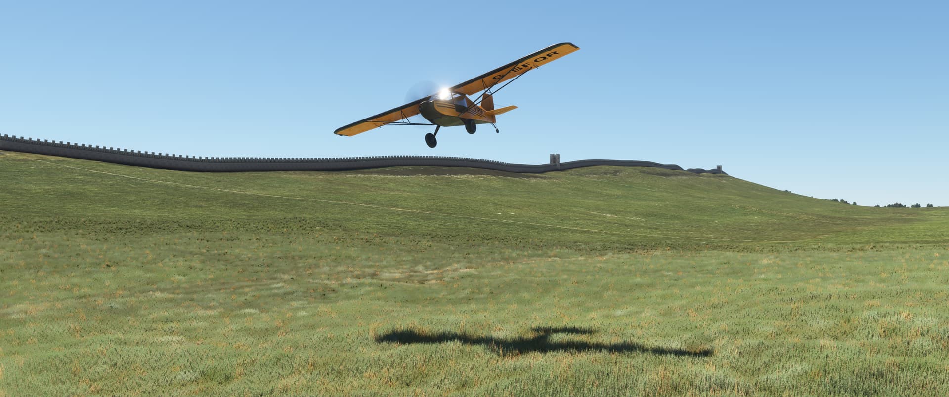
Pee-Wee and Nag Over Northumberland and Cumbria

Hadrian’s Wall, Part 1


Pee-Wee says: Welcome back, fellow explorers! Today we’ll travel to one of my favorite places on Earth: Northumberland and Cumbria in the far north of England, two of the largest but least populated counties in all of Britain. Northumberland’s eponymous national park and Cumbria’s Lake District encompass 2,000 square miles (5,180 square kilometers) of the most incredible scenery, and Northumbria alone boasts more than seventy complete castles, including Castle Alnwick, which fans of Harry Potter movies will recognize as the Hogwarts School of Witchcraft and Wizardry! :woman_mage:

Nearly two millennia ago, this area was the northwesternmost frontier of the Roman Empire and was protected by a chain of fortresses, castles, and watchtowers stretching 73 miles (117 kilometers) from Newcastle to the Solway Firth, all connected by an imposing stone wall some 15 feet (4.6 meters) tall. Today this artifact is known by the name of the emperor who masterminded its construction: Hadrian’s Wall.

For this tour, we’re breaking from one tradition: the scenery package you’ll need to see things the way we did isn’t free. Hadrian’s Wall 180 for FS2020 is available from Time Machine Designs (the same guys that brought us the wonderful and free Arrows Across America package). At £12.99, HW180 is well worth the price!

Pee-Wee’s Disclaimer: We are in no way associated with TMD, nor did we receive any compensation for this tour. Nag and I just wanted to try something different! I’m glad we did, because we learned quite a bit, and made some new friends, too! (Thanks again, Mister Pips! :face_blowing_a_kiss:)

We’ll fly this tour in three parts:

  • Part 1 takes us to some interesting sites around Newcastle and Carlisle and provides an overview of Hadrian’s Wall and the land it traverses. You can follow along in your choice of aircraft for this part.
  • Part 2 follows the Wall’s entire length, from Wallsend near Newcastle to Bowness-on-Solway northwest of Carlisle. This part won’t require off-field landings or even closeup viewing, so something fast will work just fine.
  • In Part 3, we’ll examine specific locations along the Wall in greater detail. You’ll want to fly something slow that doesn’t mind getting its feet dirty.

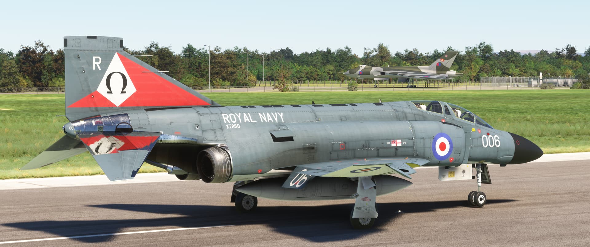
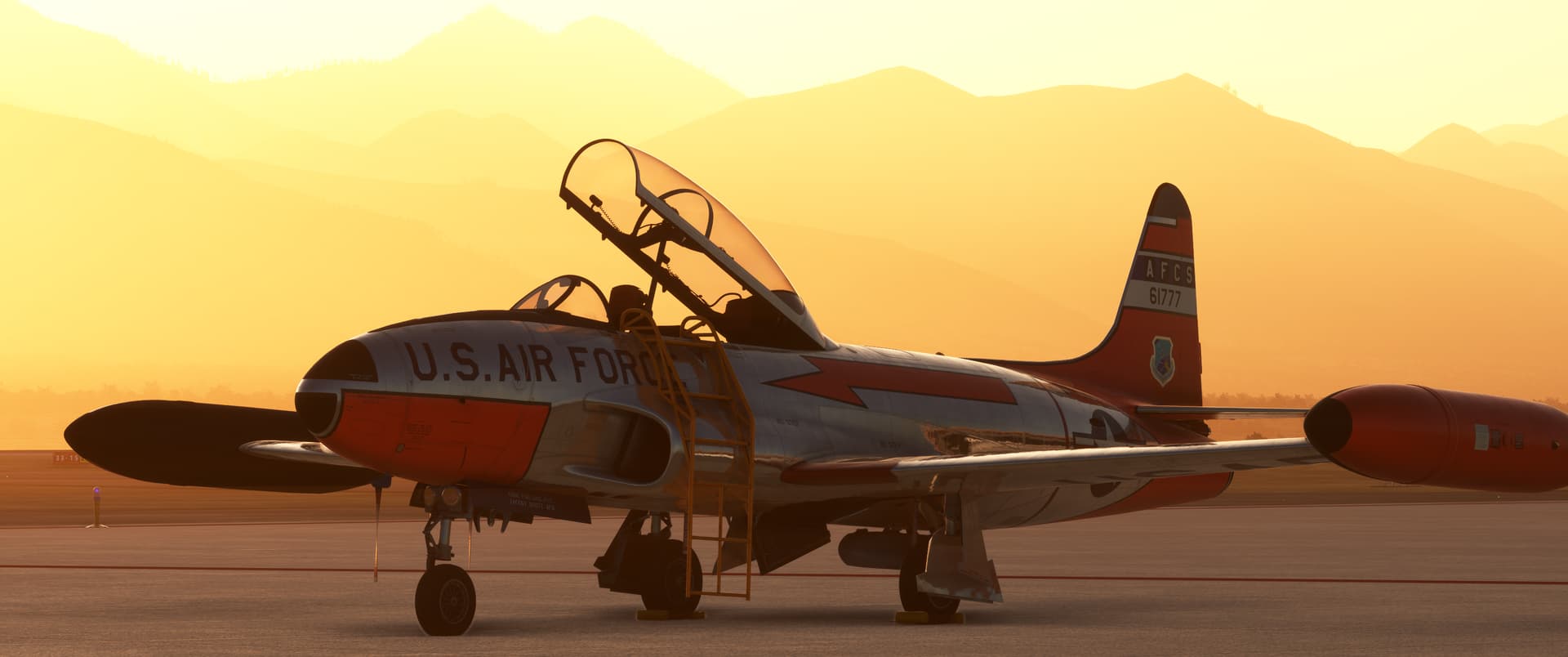
Pee-Wee says: One tour, three flights. Now that’s getting your money’s worth! :blush: We (well, I) chose DC Design’s Phantom FG.1 for the first flight.


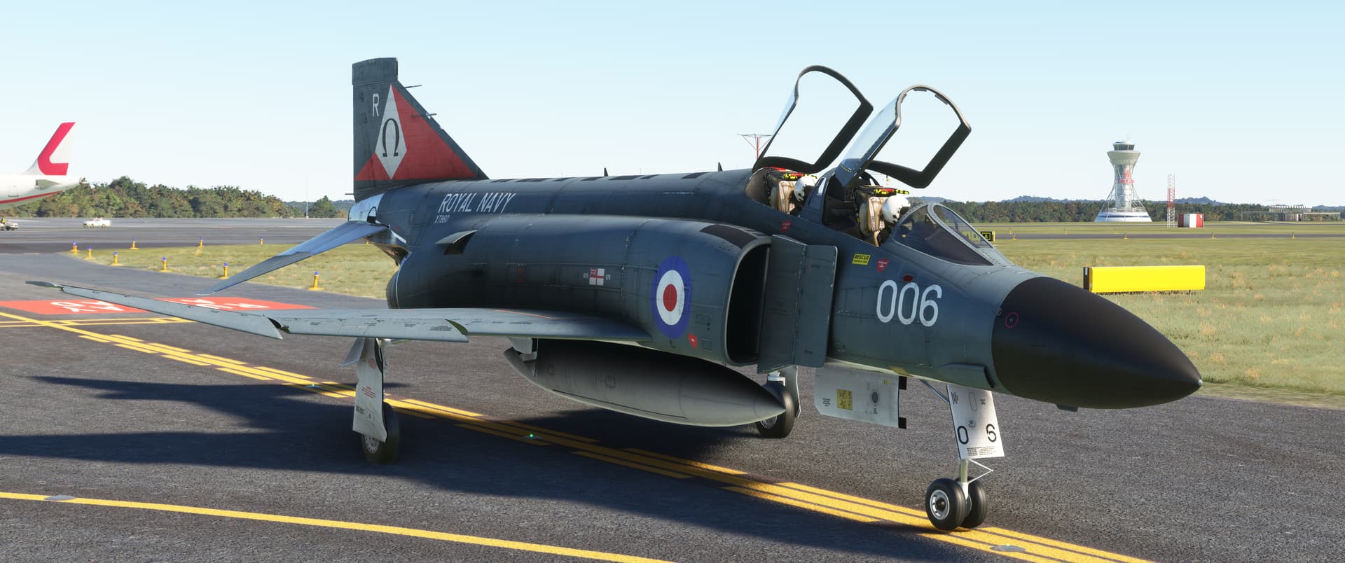
Pee-Wee says: Here’s my favorite XT860, one of the RN’s first Phantom FG.1s, ready to go at Newcastle. You’ll probably remember this grand old lady from my tour through Rainbow Canyon and Death Valley. She later flew for the RAF’s 43 Squadron but was lost in 1988. Thanks to Merida72 at flightsim.to for the brilliant Royal Navy Phantom Pack.

The Royal Navy originally ordered five squadrons-worth of these custom Spey-powered Phantoms, but the 1960s were tough on the British military and the Royal Navy in particular: only 48 of the original 140 aircraft were delivered, and twenty of those went directly to the RAF. The remainder followed after the Phantom’s final cruise aboard HMS Ark Royal in 1978.

Pee-Wee says: We won’t wade into politics here, but it goes without saying that while the Sea Harrier was a wonderful fleet defender, in April 1982 the British sorely missed their large carriers and air wings. Thankfully, the RAF saved the day by burning hundreds of thousands of gallons of jet fuel to deliver 63 bombs (42 of which missed) and four Shrike missiles (three of which missed) to the Falklands/Malvinas. Yay for the RAF. :roll_eyes:

Down, girl.

Pee-Wee says: Sorry.

Need a minute? We have three flights to finish.

Pee-Wee says: No, I’m good. Mind if I fly the Phantom? You can fly the next one.

Deal.

Pee-Wee says: Oh, we almost forgot the waypoints! Here ya’ go. :blush: We recommend starting at Newcastle (EGNT) and landing at Carlisle (EGNC).

Waypoint Coordinates Lat/Long (Skyvector)
North East Land, Sea & Air Museum / RAF Usworth 54.9240 -1.4698 545527N0012811W
Northumberlandia / Cramlington Aerodrome 55.0887 -1.6281 550519N0013741W
Alnwick Castle 55.4157 -1.7061 552457N0014222W
We’ll Reveal This One Later… :zipper_mouth_face: 55.1155 -3.3585 550656N0032131W
Anthorn Radio Station 54.9103 -3.2797 545437N0031647W
RAF Silloth 54.8718 -3.3633 545218N0032148W
Watchtree Nature Reserve / RAF Great Orton 54.8745 -3.0770 545228N0030437W


:one: Never say NEVVAA: RAF Usworth and the North East Land, Sea & Air Museums

Pee-Wee says: Our first stop is the former RAF Usworth in the rolling farmland between the rivers Tyne and Wear south of Newcastle. The Royal Flying Corps’ Cramlington-based No. 36 (Home Defense) Squadron operated a detachment here during World War 1, with another further south at Seaton Carew from where 2nd Lieutenant Ian Pyott downed the German Zeppelin L34 off the coast of Hartlepool on the night of 27 November 1916.

Strange coincidence of the day: L34’s commanding officer, 46-year-old Kapitänleutnant Max Dietrich, was the uncle of famed actress Marlene Dietrich. He and his crew of nineteen perished in the crash.

World War 2 brought another flurry of activity at Usworth, including the construction of two paved runways and additional barracks in the new North Camp across Washington Road. The RAF Auxiliary’s locally raised and battle-hardened No. 607 (County of Durham) Squadron flew Hawker Hurricanes here during the Battle of Britain, adding four kills to the more than 70 the unit scored during the Battle of France.

Pee-Wee says: Did you know a Gestapo spy served in the RAF? Czech pilot Augustin Přeučil was a flight instructor at Usworth, having been recruited by the Nazis before being evacuated to England after the Fall of France in June 1940. The following year he flew a stolen Hurricane to Belgium and made his way back to Czechoslovakia to further assist the Nazis. He was captured after the war, convicted of treason, and hanged. You can read more about him here.

Huh. I’d never heard that story.

Pee-Wee says: There are plenty of words for guys like that, but the forum won’t let me type any of them. Trust me: I tried. I suppose I’ll just stick with “dirtbag.” :angry:

Hey, if he was an instructor, does that mean student pilots went to him for their…Czech rides?

Pee-Wee says: Ooh. Well played! :two_hearts:

Usworth became Sunderland Airport in 1962 serving the general aviation community, although upstart Tyne Tees Airways briefly provided charter services here using Dakotas and an eclectic mix of other types. Nissan Motor Manufacturing UK purchased the Sunderland Airport in 1984 and built a massive car factory on the site. Today several associated companies share the land, and virtually no trace of the airfield remains.

Pee-Wee says: In March 1974 some local aviation and history enthusiasts began meeting regularly at Sunderland, and an official association blossomed: the North East Vintage and Veteran Aircraft Association (NEVVAA). The group began purchasing and displaying historic aircraft from around the United Kingdom, amassing a substantial collection at Sunderland. The group changed its name to the North East Aircraft Museum, and after merging with two other museums in the early 2010s, became the North East Land, Sea & Air Museums (NELSAM). Today, visitors can see everything from double-decker busses to strategic nuclear bombers and armored personnel carriers at this wonderful little museum!

Some of the more interesting aircraft displayed here include:

Dragonfly WG724: The museum’s first aircraft purchased from a scrapyard in March 1975, this naval helicopter was first displayed at Lambton Pleasure Park in nearby Bournmoor near the current intersection of Chester Road and the A183. She’s still here, fully restored and displayed proudly in the Navy hangar.

Vulcan B.2 XL319: The museum’s crowning acquisition arrived on 21 January 1983, having been flown directly from RAF Waddington. She was the first Vulcan released for public display and the largest aircraft to ever land at Sunderland Airport. She’s been cleaned up recently and even ran one of her engines several years ago!

Trident 1C G-ARPO: The only complete Trident 1 remaining in England, ARPO was undergoing restoration by the Save the Trident team but was officially taken up by the NELSAM in 2023. She’s painted in not-quite-accurate Northeast Airlines colors (Northeast operated Trident 1Es, not 1Cs). Look carefully and you’ll see her vertical and horizontal stabilizers on blocks east of the museum’s main building, and her wings directly behind her fuselage. Here’s hoping she’s fixed up right soon!


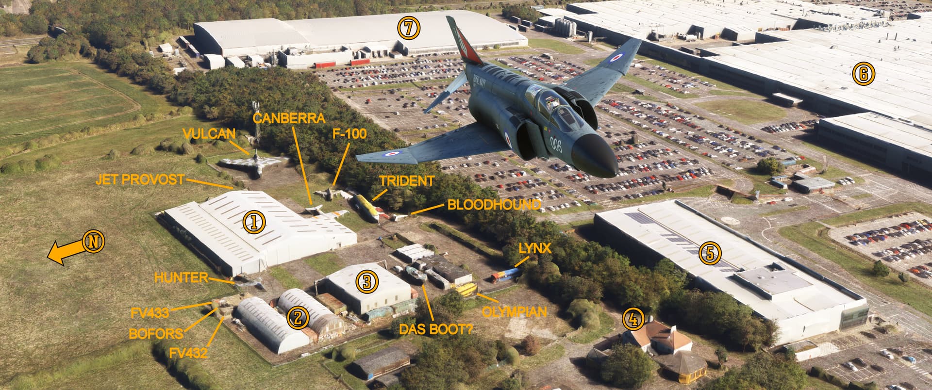
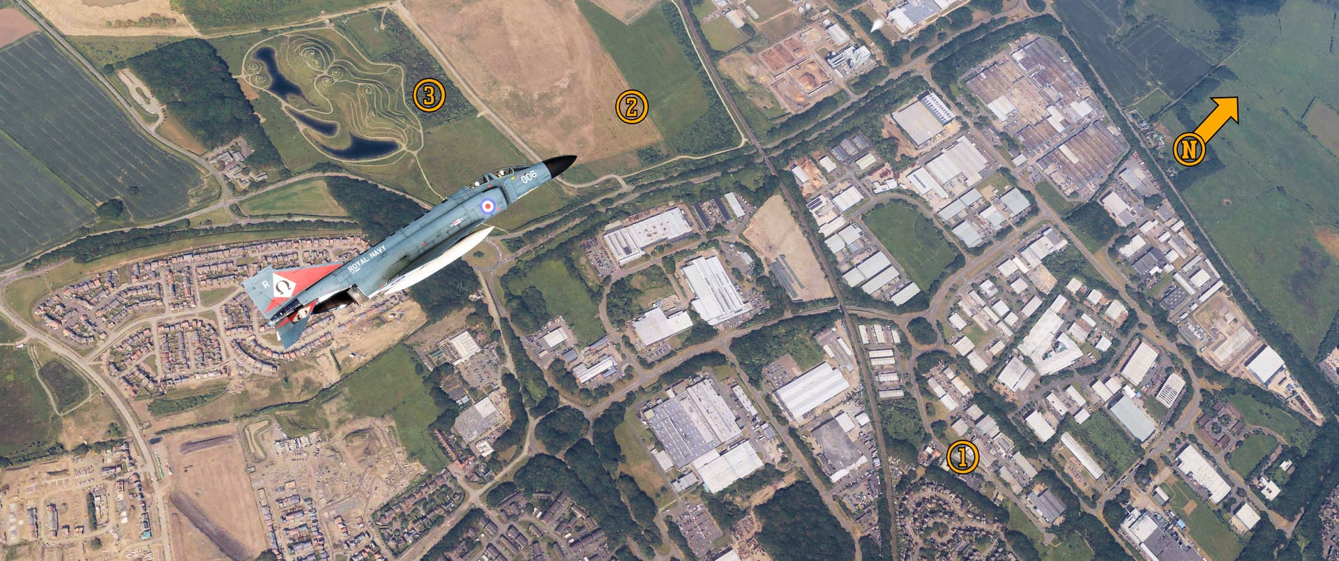
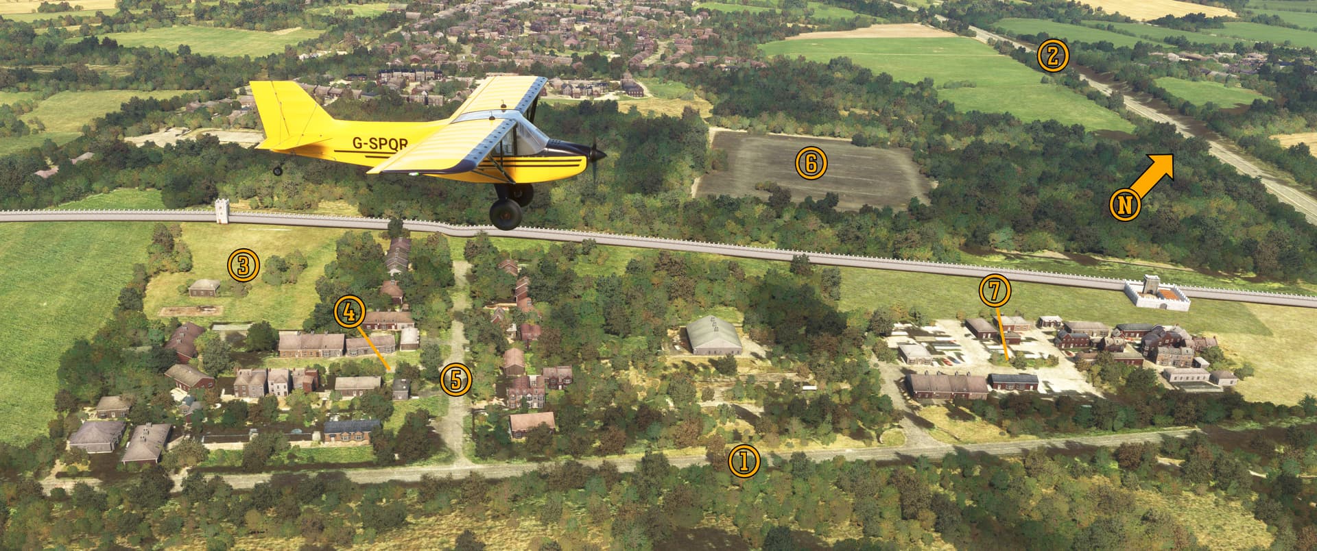
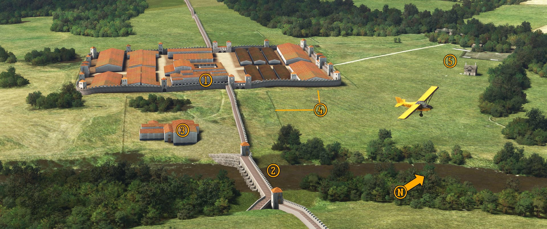
Pee-Wee says: Here we are flying west over the (1) NELSAM. There’s quite a few powerlines and other obstructions here, so be careful! The land vehicles and naval artifacts are displayed in these two (2) Romney Huts. This (3) larger hangar is used for restoration and maintenance work and isn’t open to the public. The museum sits on what was Usworth’s North Camp, but none of the original structures remain, and the only military presence is the 2214 Air Cadets Squadron, which occupies the two buildings west of the Romney Huts. Over here is the (4) Rustica Trattorica Italian restaurant, formerly the Three Horse Shoes public house and RAF Usworth Officer’s Mess.

Across the street on the former airfield proper is the (5) Driving the Electric Revolution Industrialization Centre North East where Newcastle University and the University of Sheffield work to develop new electric production technologies. The former airfield itself is completely covered by (6) Nissan’s car factory where gas or hybrid Juke and Qashqai crossovers are produced. Behind our Phantom is (7) AESC’s new car battery gigafactory, a joint venture between Nissan and the Tokin Corporation.

Wait a second. “Das Boot?” What’s that all about?

Pee-Wee says: Well, that thing sure looks like the hull of a boat, but I can’t figure out which one, and in real life it’s not there anymore. If anyone knows its identity—or what the heck it really is—please respond here. Thanks! :face_blowing_a_kiss:


:two: Zounds! What Mounds!: Northumberlandia

Our next stop is the abandoned Cramlington Aerodrome, the first Royal Flying Corps airfield in northeast England. Number 36 (Home Defense) Squadron was formed here during the Great War to defend the industrial northeast from German Zeppelin raiders. Aviation enthusiasts established the Newcastle upon Tyne Light Aeroplane Club here in 1925 and a commercial enterprise soon followed. Cramlington remained active until 1935 when all its operators moved to the new Woolsington Aerodrome (now Newcastle International Airport). Nothing remains of this pioneering airport today except an open field, the western portion of which is encroached upon by the Shotton Surface Mine.

Pee-Wee says: The Royal Navy built the Cramlington airship station to the east, and four SS Class patrol blimps operated there during the Great War. The 300-foot (91-meter) shed wasn’t completed until after the war and the Airship Development Company’s advertising blimp G-FAXX was the only airship to shelter there. The shed was razed in 1967, and nothing remains of RNAS Cramlington today.

I’d love to chat more about the airship station, but we’re here for another less modest reason! In 2004 the Banks Group (owners of the Shotton Surface Mine), the neighboring Blagdon Estate, and American landscape artist Charles Jencks schemed to build a massive land sculpture and public park from the mine’s overburden. Construction began in 2010 and Northumberlandia—“The Lady of the North”—opened six years later. One hundred feet (33 meters) tall and one quarter mile (402 meters) long, she is reportedly the largest female sculpture in the world.


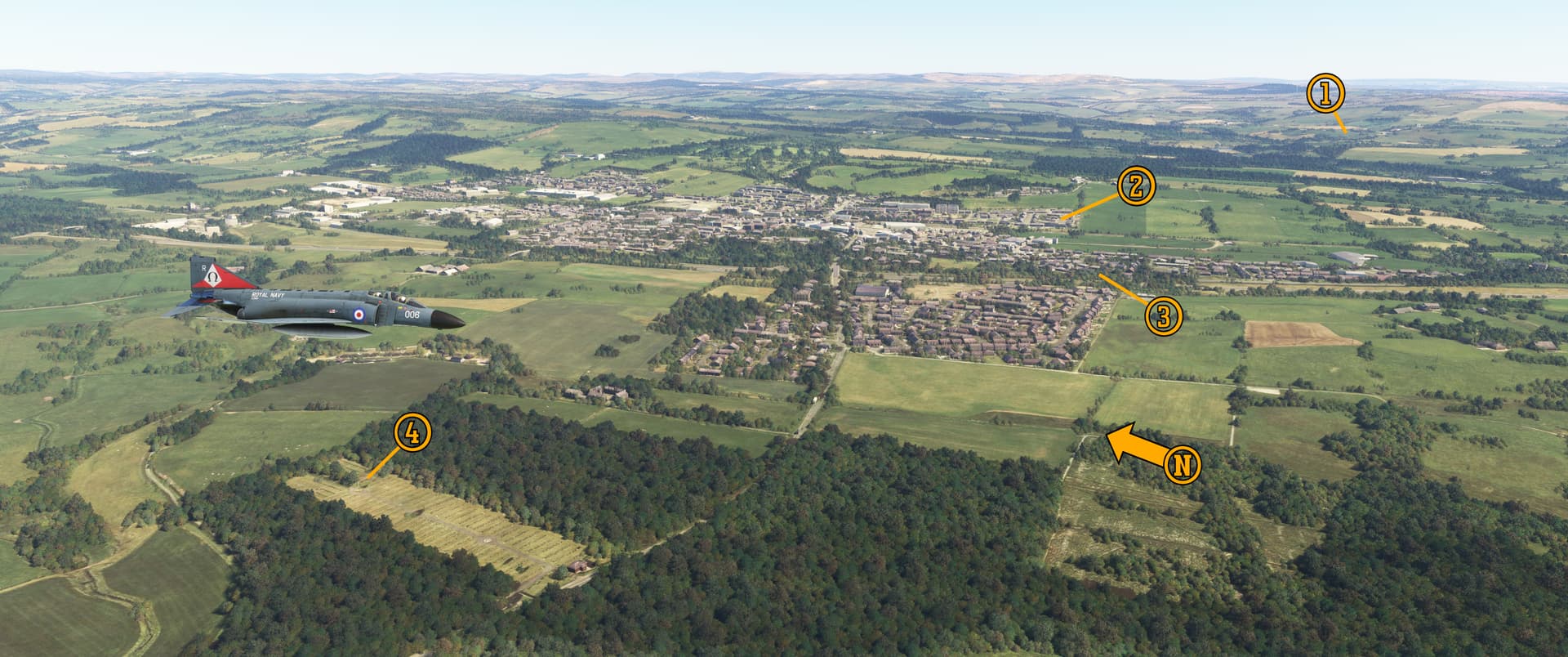
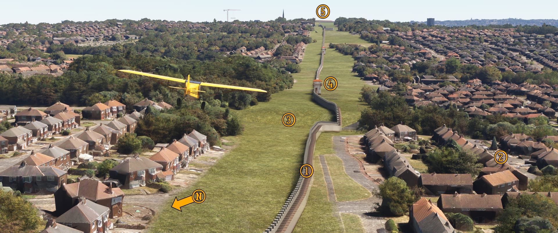
Pee-Wee says: Here we are turning to the north over Northumberlandia and the former Cramlington airfield and airship station. The airship hangar was located on the southern edge of the landing field right about (1) here, oriented northeast to southwest. Cramlington Aerodrome was located in (2) this field, with the hangars at the point of our Phantom’s nose.

And (3) here’s the Lady of the North. Her head is near the top of the photo. :wink: She’s wheelchair accessible and open daily, but if you want a bite from the café, you’ll need to be here between 10 a.m. and 4 p.m. in Summer. There’s no entrance fee, and well-behaved dogs are welcome.

For those of you in helicopters or STOL airplanes, there’s plenty of interesting screenshot opportunities down there. Have fun and remember this is a family friendly forum! :innocent:


:three: Exitus Per Tabernam Donorum!: Alnwick Castle

Exitus Per Tabernam Donorum? What’s that?

Pee-Wee says: It’s the magic spell that turns a place into a tourist trap. It’s Latin.

What’s it mean?

Pee-Wee says: “Exit Through the Gift Shop.”

Ah. Very fitting.

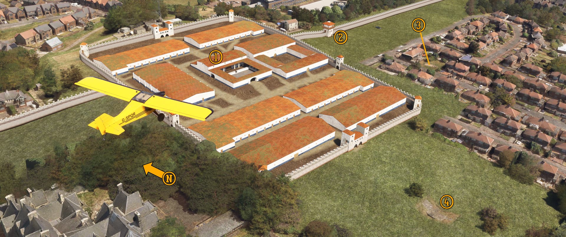
Pee-Wee says: Yes, Harry Potter fans, next up is Alnwick Castle, current seat of the 12th Earl of Northumberland and filming location of Harry Potter and the Philosopher’s Stone and Harry Potter and the Chamber of Secrets.

I’ve never seen the movies.

Pee-Wee says: Really?

I read the books.

Pee-Wee says: Well, I’ve only seen the first two, and I can confirm that the books were better. Maybe we should binge watch the others on your next days off?

It’s a date. :blush:

Alnwick Castle dates back to the very beginning of the 12th Century when English nobleman Ivo de Vesci built the first fortifications here overlooking the River Aln. Sir Henry Percy, the 1st Earl of Northumberland, purchased the greatly expanded Alnwick in 1309, and his descendants live here today.

Like many English castles and manor homes, Alnwick Castle flirted with financial ruin during the early 20th Century, and the Percy family looked for ways to keep their home afloat. In 1954 they turned to the motion picture industry with the filming of Prince Valiant, in which Alnwick stands in for King Arthur’s Camelot. Other films and television productions followed, including Ivanhoe (1982), Robin Hood: Prince of Thieves (1991), Transformers: The Last Knight (2017), and Downton Abbey (2015-16).


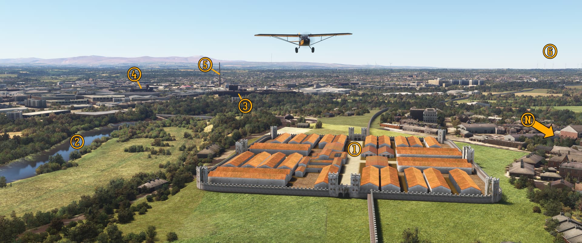
Here’s Alnwick Castle overlooking the market town Alnwick and the River Aln. Unfortunately, Alnwick is represented by a questionable assemblage of autogen buildings in MSFS. This detailed representation is included in Orbx’s Great Britain Central package.

Harry’s first broom flying lesson was filmed here on (1) the outer bailey’s south lawn. He learns the ins-and-outs of Quidditch on the (2) north lawn. Various scenes of Hogwarts students walking between classes were filmed here in (3) the central courtyard. The Whomping Willow lives over here in the (4) inner bailey, which is also where the Weasley’s enchanted Ford Anglia rudely deposits Harry and Ron in The Chamber of Secrets.

There’s more to Alnwick Castle than filming locations. The Fusiliers Museum of Northumberland is located in the (5) Abbot’s Tower and the (6) Postern Tower contains the Percy family’s art and artifact collection. In the (7) Constable’s Tower you’ll find military displays related to the Percy family and its contributions during the Napoleonic Wars.

Alnwick is open daily from 10 a.m. to 5 p.m. Tickets cost £23.95 (about $32) at the gate but are 10% less online.

(By the way, we actually did watch all the movies last weekend, and she was right: the books were better. :smirking_face:)


Next we flew approximately 90 miles (145 kilometers) northwest into Scotland to our next site, but we’ll delay talking about it until Part 2. It’ll make more sense then! :+1:

For now, let’s skip to our next location in Dumfries and Galloway south of Glasgow. It’s a potentially upsetting place, so jump ahead to :five: if you want, or click on the blurred text to read on.


:four: Lockerbie

There really isn’t much to say about this town in the Scottish Uplands that hasn’t already been said. If you don’t know the story, read this.


Here we are passing west of Lockerbie, flying south toward Carlisle. Clipper Maid of the Seas’ forward fuselage and flightdeck landed in a (1) field opposite the Tundergarth Church, where today you’ll find the Lockerbie Air Disaster Remembrance Room, a public memorial to the victims, three of whom are interred in the church’s cemetery.

Maid of the Seas’ wings, engines, and center fuselage landed on (2) Rosebank and (3) Sherwood Crescents in the south of Lockerbie, destroying fifteen homes and gouging a massive crater.

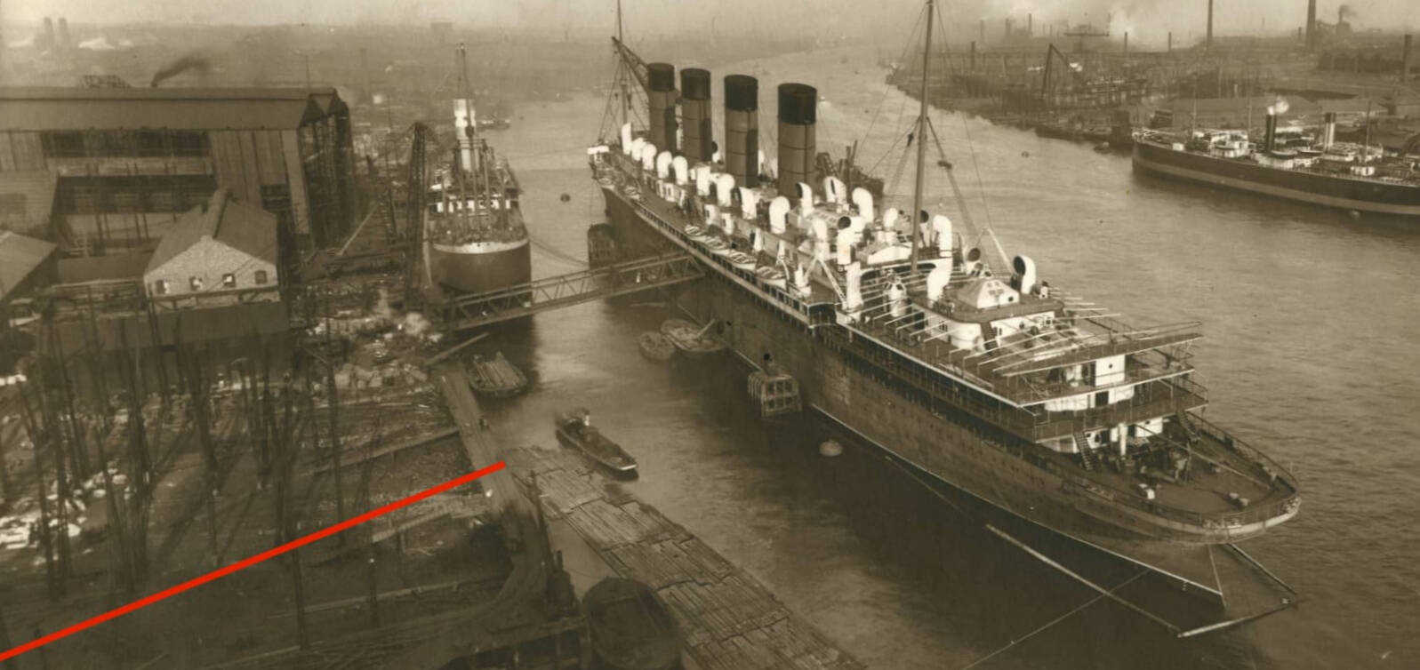
The winds aloft carried debris more than 20 miles (32 kilometers) to the east, beyond Langholm (not visible behind the hills in the distant center of our photo). Much of Maid of the Seas remains interred with the Air Investigations Branch (AIB) at Farnborough, but a large portion rests in a scrapyard near RAF Coningsby in Lincolnshire.

The Lockerbie Memorial Garden is located off Sherwood Crescent, and a (4) Garden of Remembrance is located in the Lockerbie (Dryfesdale) Cemetery west of town. Both are open to the public.

One man—a Libyan—was convicted of bringing down Maid of the Seas but served only ten years of his life sentence before being released on “compassionate grounds” due to his advanced cancer. He maintained his innocence until his passing in 2012. A second Libyan man is currently on trial in the United States.

The bombing claimed the lives of 270 passengers, crew, and townspeople and remains the deadliest terror attack in the UK’s history.

Anything to add?

Pee-Wee says: No. :pensive_face:

Okay.


:five: All Your Base Are Belong To Us: RAF Silloth and Great Orton, and RNAS Anthorn

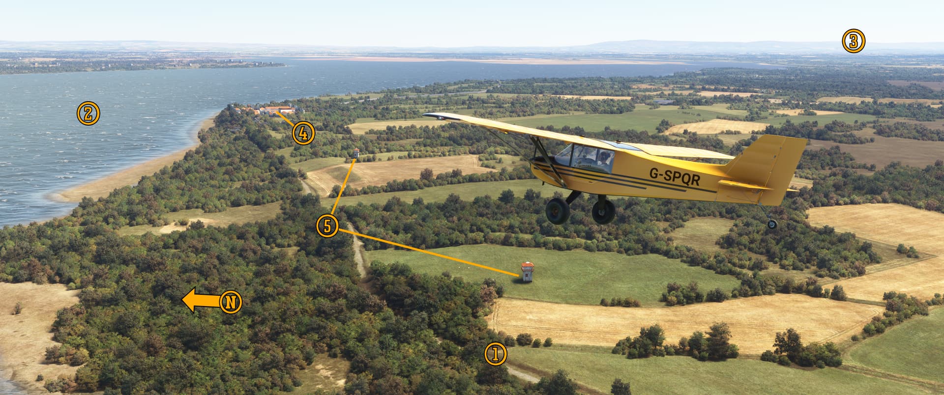
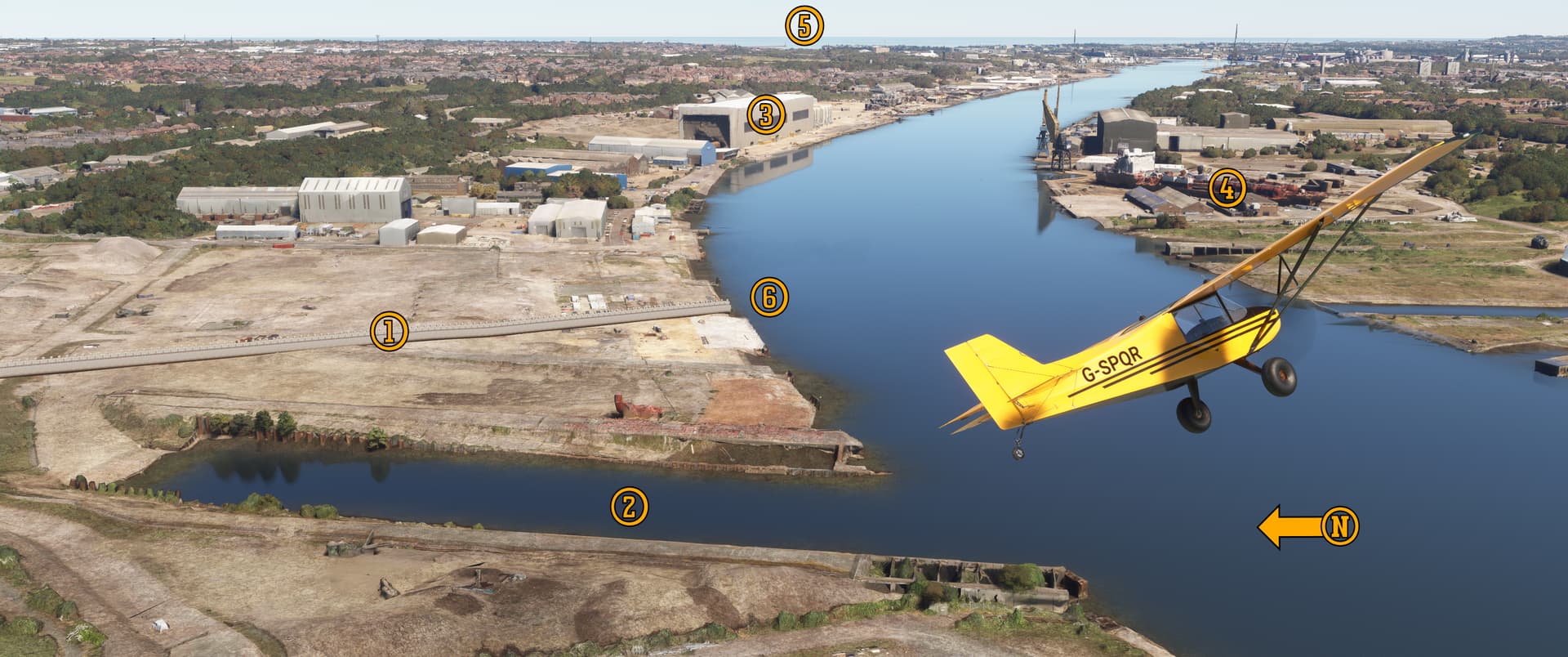
Pee-Wee says: We’ll leave Scotland now and head across the Solway Firth into Cumbria. (For our fellow Americans, “firth” is the Scottish word for “river estuary.”) On the coastal plain west of Carlisle are four World War 2–era airfields: three RAF and one Royal Navy. Let’s take a look at three of them.


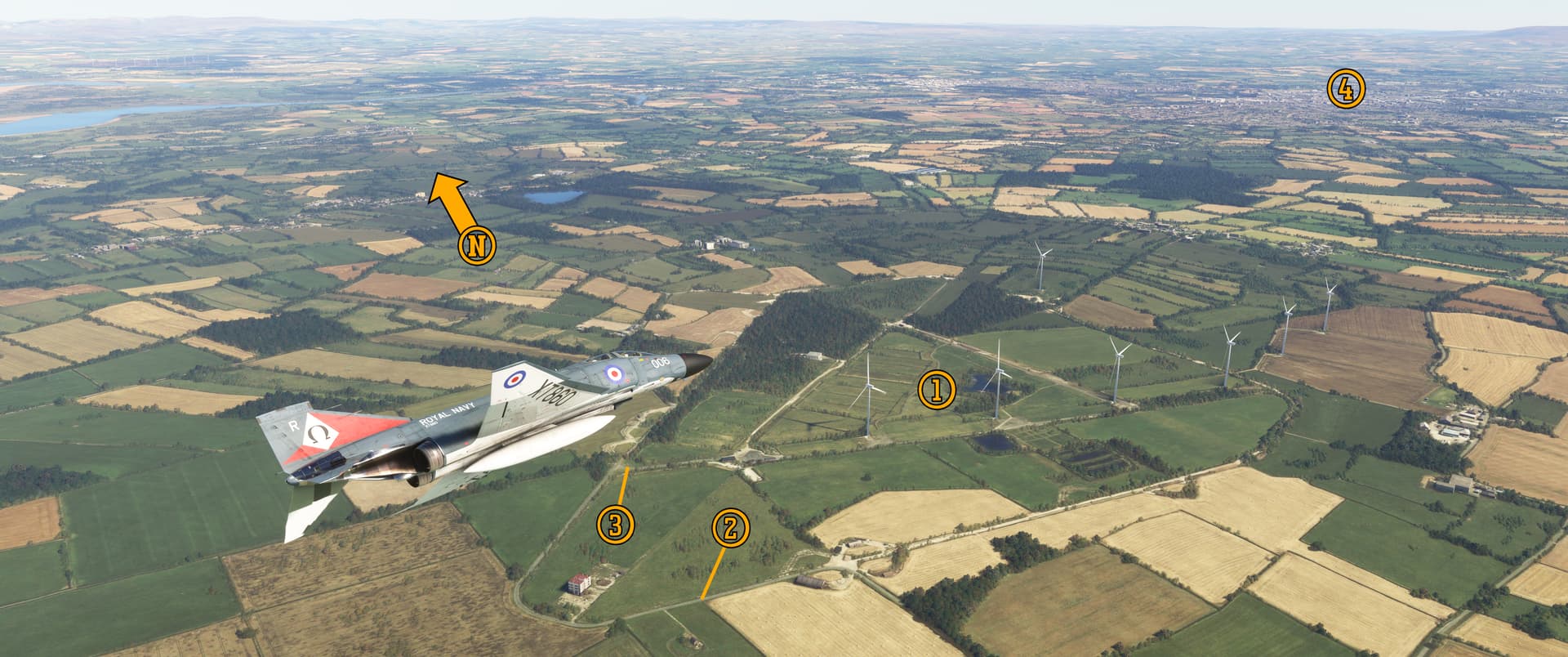
In this southwest facing screenshot, we’re flying over (1) Anthorn Radio Station, formerly RAF/RNAS Anthorn, aka HMS Nuthatch. Built for the Royal Flying Corps during the First World War and reactivated for the Royal Navy during the Second, Anthorn was a depot where newly delivered Corsairs, Seafires, Barracudas, and Fireflies were modified to service standard. It reopened in 1964 as a NATO very low frequency (VLF) transmitter station for communicating with submerged submarines. LORAN and other transmitters were added later, and today, thirteen guyed masts ring the former airfield. Most of Anthorn’s runways and perimeter track remain intact, but watch out: some of those masts have cables running between them!

Pee-Wee says: Yes, the Royal Navy’s shore stations are traditionally named like commissioned ships (i.e. HMS Nuthatch for RNAS Anthorn). I’ve read various explanations online, but it seems the real reason may be lost to history. The tradition continues today with HMS Heron, Seahawk, Nelson, Dartmouth (Yeovilton, Culdrose, Portsmouth, and Brittania Royal Navy College), and others.

In the distance is (2) former RAF Silloth, once home to several RAF Coastal Command and training units. Apparently, much of the in-flight footage of RAF Lockheed Hudsons in the 1941 Tyrone Power and Betty Grable film A Yank in the RAF was filmed here.

Pee-Wee says: Back in World War 2, MacDill Airfield in Florida earned the slogan “one a day in Tampa Bay” thanks to the regularity with which its B-26 bombers ended up in the water during training flights. Similarly, the Solway Firth earned the nickname “Hudson Bay!”

Silloth was where the world’s first “crew procedures trainer” entered service. The “Silloth Trainer” used the forward fuselage of a Halifax bomber outfitted with pneumatics, hydraulics, accurate instrumentation, and aircrew equipment. For the first time, aircrewmen could practice emergency drills as a crew. The device was apparently successful, as at least fourteen others were built for other training stations around the United Kingdom. Unfortunately, none remain today.


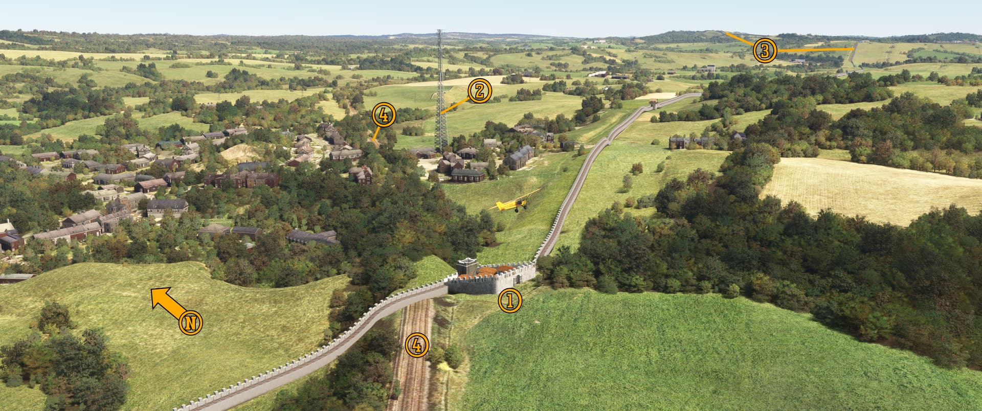
Pee-Wee says: Here’s (1) former RAF Great Orton, once the home of Wellington and Hurricane operational conversion units. Used for storing munitions until 1952, Great Orton was declared surplus and returned to farmland. Ten wind turbines were built here in 1992, but four were removed seven years later. (Oddly, there are seven turbines here altogether. We have no idea who the seventh belongs to!) Much of the airfield’s (2) perimeter track remains intact, and you can still see the original aircraft dispersal diamonds.

Back in 2001 Great Orton became the epicenter of the catastrophic Foot and Mouth Disease outbreak that ravaged Britain’s livestock population. More than 500,000 sheep, cattle, pigs, and other animals were culled and either buried in mass graves or burned at Great Orton. Today the former airfield is the public Watchtree Nature Reserve, and a small memorial to the animals killed here is located at (3) the park entrance. That’s (4) Carlisle in the distance. We’ll land there in a few minutes, but first…

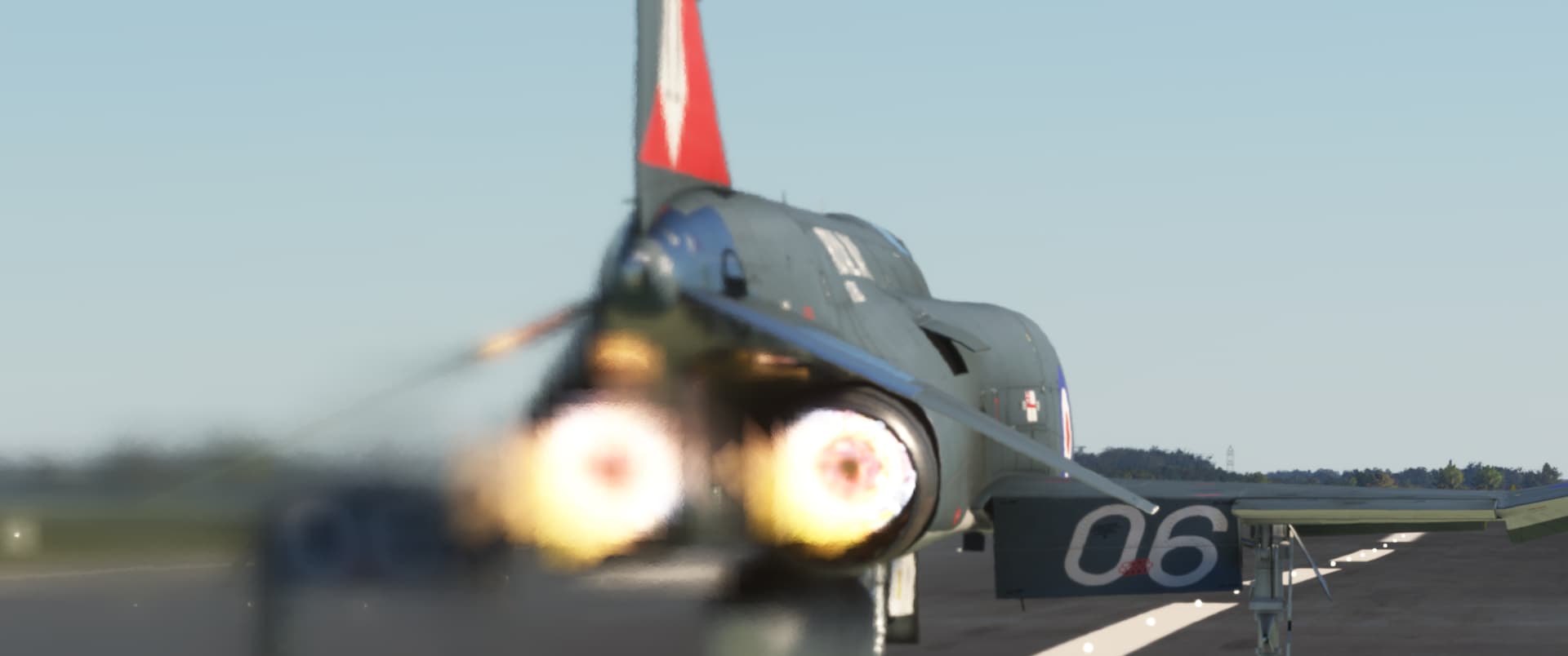
Pee-Wee says: Our Phantom’s Speys produce a combined 41,000 pounds of thrust in full burner at sea level, and by this point in our flight, XT860 weighed about 41,000 pounds, so…sea level to 20,000 feet in about thirty seconds. Boo. Yah. :smiling_face_with_sunglasses:


:six: Beyond Here Be Dragons…and Barbarians: Hadrian’s Wall

Now for the main event. What is Hadrian’s Wall? Was it really just a wall?

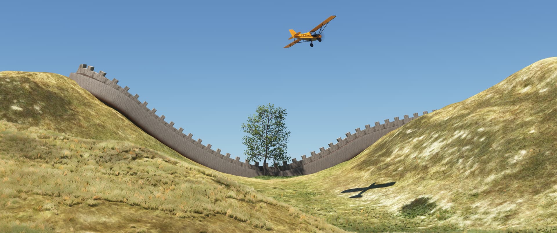
Pee-Wee says: It was a wall, but not “just a wall.” Imagine a stone wall the height of a semi-truck trailer stretching from Manhattan to Philadelphia, or London to Southampton, or Berlin to Leipzig. It was a really big wall.

Why was it built here?

Pee-Wee says: Late in the 1st Century AD, the Romans conquered Caledonia—the land we know today as Scotland—but were forced to abandon the territory when the occupying legions were needed elsewhere. The Romans “strategically redeployed” to the land between the Solway Firth and River Tyne, the narrowest point on the island they called Britannia. When you’re building a wall from stone and earth, every mile matters!

Huh. So, why did they build the wall?

Pee-Wee says: That’s a tough question, because there’s no consensus among historians. Some say that Emperor Hadrian chose to consolidate his empire rather than further expand its borders and “sealed” its edges accordingly, while others believe the wall was designed to protect the empire from “barbarians” to the north. A wall with forts and gates also allowed control, taxation, and observation of people and goods crossing the border in both directions.

But the most likely reason is far simpler: compared to the costs of manning, training, and supplying a large army to occupy lands with such a small tax base and virtually no natural resources, the wall is like a water-cooled, graphite-moderated reactor with a positive void coefficient:

Nice.

Pee-Wee says: Thanks! I worked hard for, like, two minutes on that.

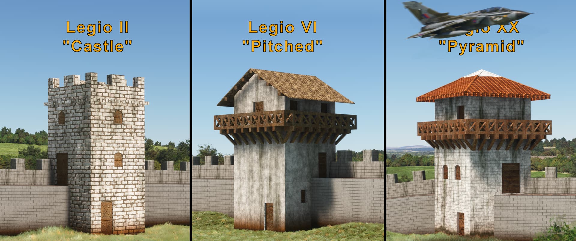
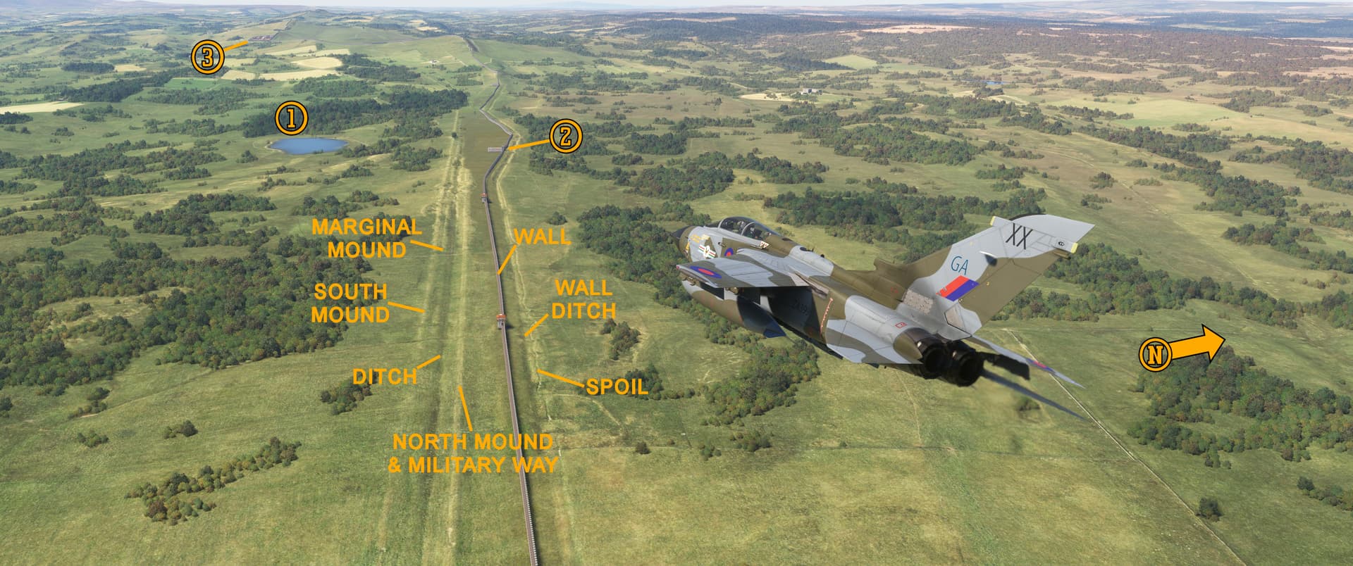
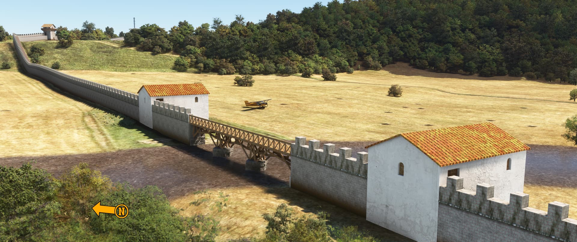
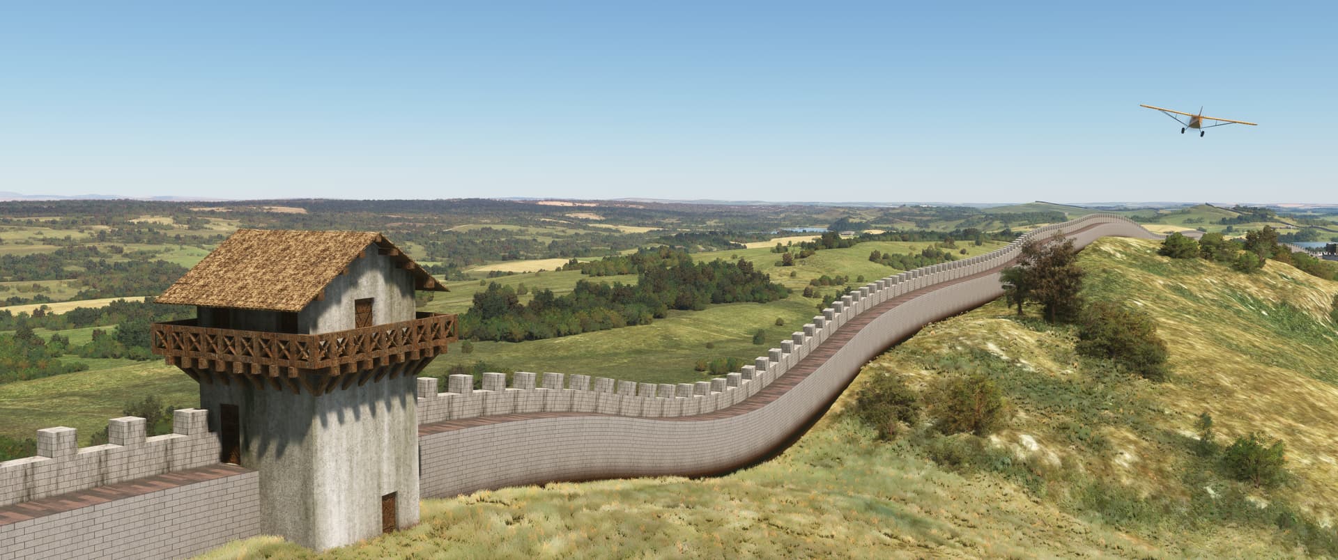
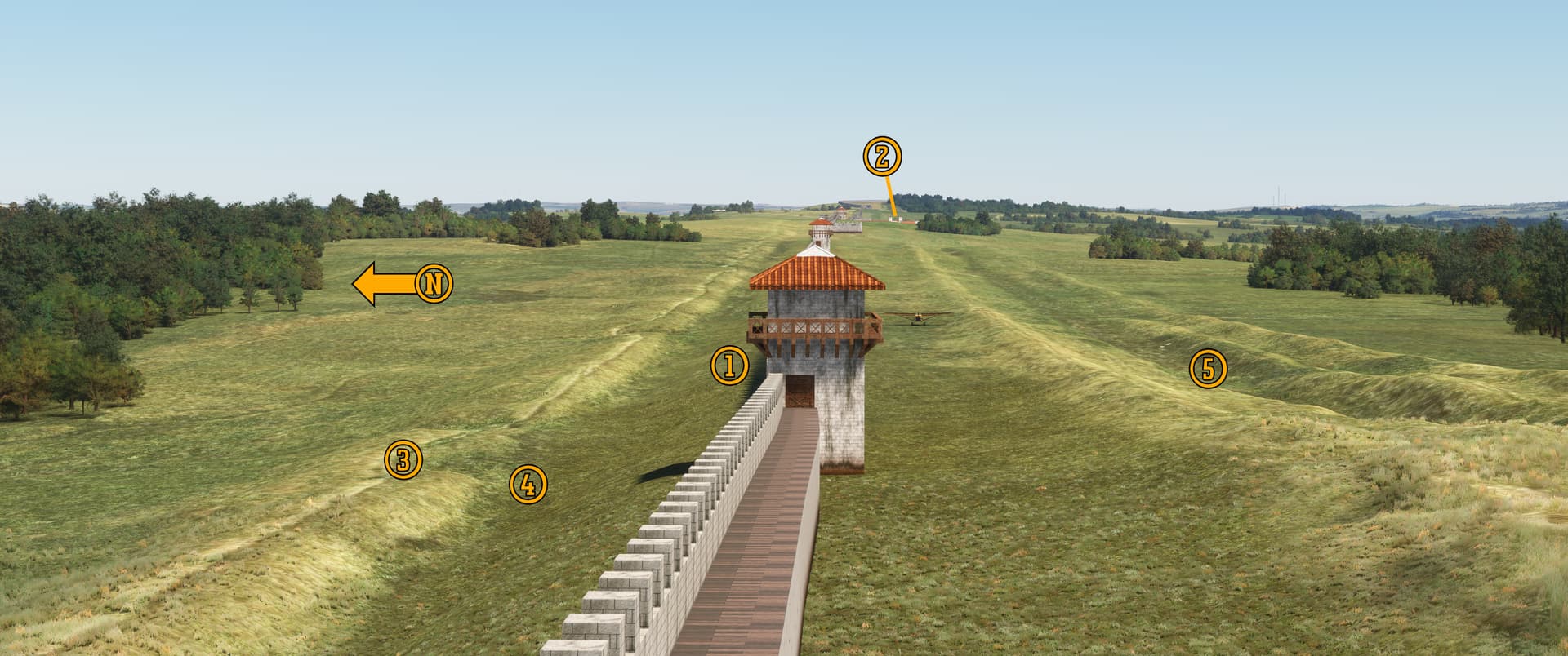
Construction of Hadrian’s Wall took approximately six years beginning in 122 AD. Its garrison of 9,000 auxiliary infantrymen and cavalry occupied forts, milecastles, and watchtowers spaced so that anyone attempting to breach the wall was never more than 900 feet (275 meters) from Roman sentries, and the roadway connecting the fortifications meant that reinforcements were only a few minutes away. A trench with obstacles arranged like vegan barbed wire ran along the northern face to ensnare any would-be invaders, and the wall’s tightly packed, lime washed stones made climbing its face nearly impossible.

Shimmering white in the sunlight, the imposing edifice slicing through the countryside was the ultimate expression of Roman authority.


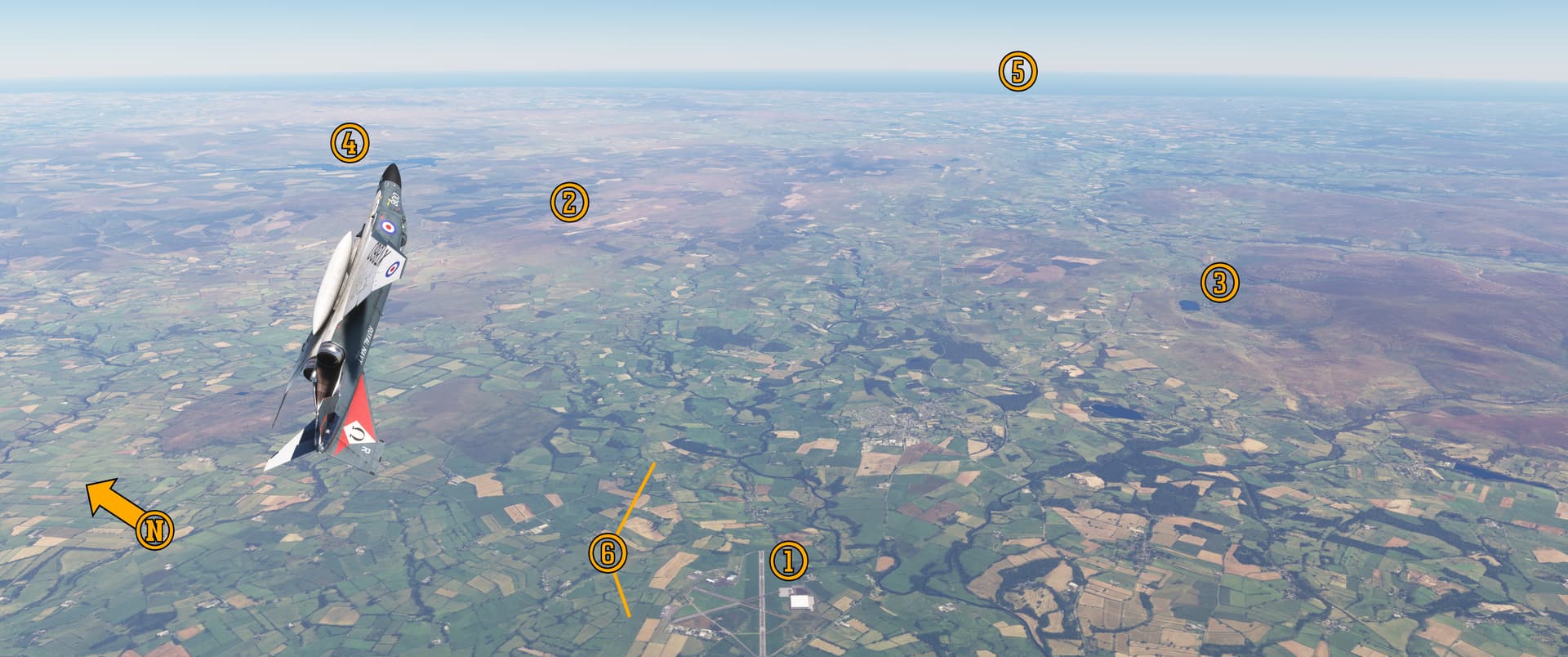
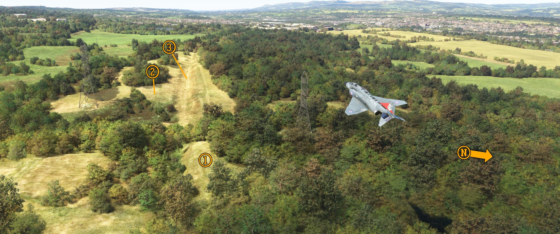
Pee-Wee says: Here we are sailing over the top, looking down onto Cumbria and Northumberland, the Roman frontier. Below is the (1) Carlisle Lake District Airport, formerly RAF Crosby-on-Eden, and to the northeast is the RAF’s electronic warfare training range at (2) Spadeadam where the Blue Streak intermediate range ballistic missile was first tested. (You can see the test stands here, and one of five remaining missiles here. Unfortunately, there’s nothing there in MSFS.)

This valley is formed by the (3) North Pennines to the south and the (4) Cheviot Hills to the north. At our Phantom’s nose is Kielder Water, the highest capacity man-made lake in the United Kingdom, and in the far distance is (5) Newcastle, only 46 nautical miles (85 kilometers) away as the crow flies.

Pee-Wee says: Look carefully and you’ll see (6) Hadrian’s Wall winding its way across hill and dale toward Wallsend. We’ll get a much closer look in Parts 2 and 3.


Pee-Wee says: Well, that was a fun flight, and…whoa! Is that a Vulcan?

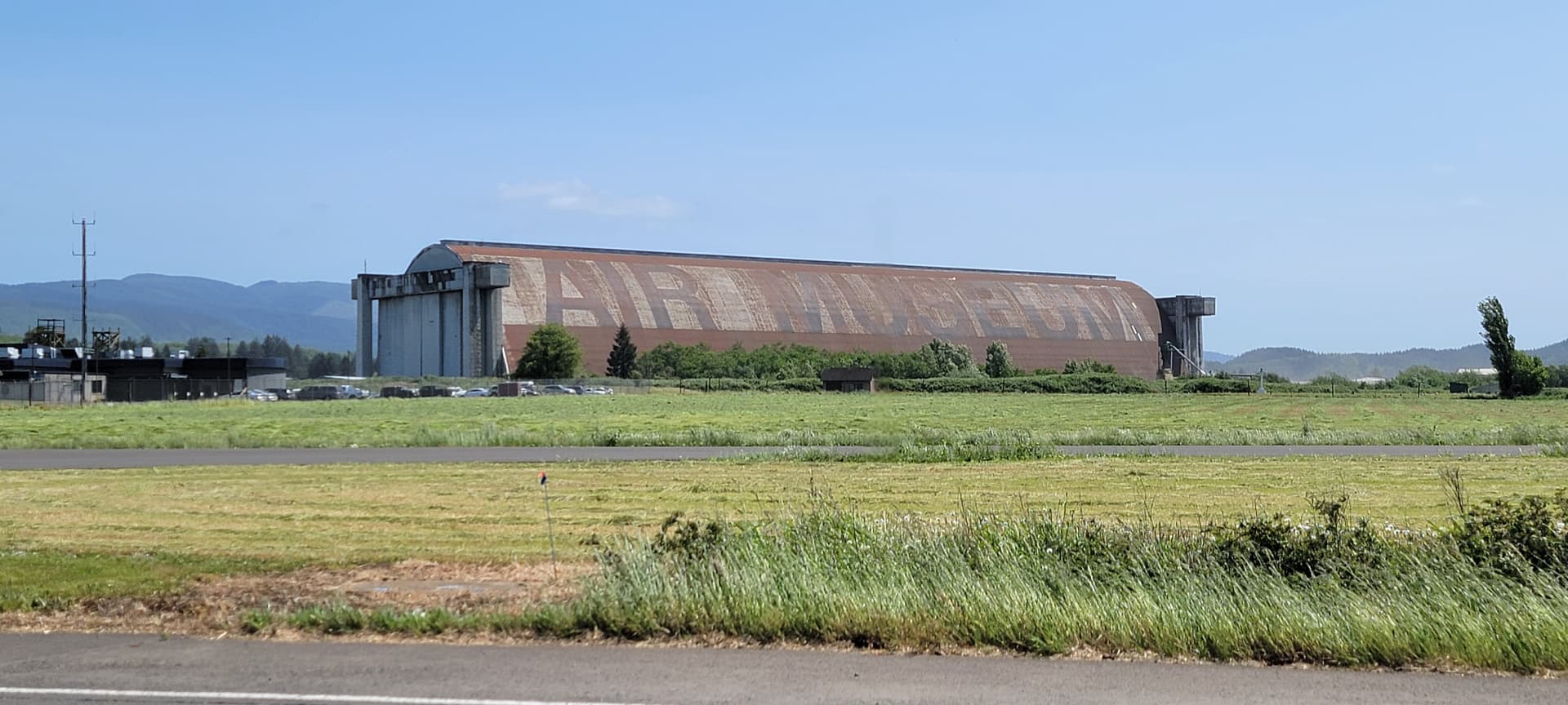
It sure is! Skell300’s excellent freeware Carlisle Airport scenery (seen in this screenshot) and UK2000’s payware package include Vulcan XJ823 at the Solway Aviation Museum. She was flown here in January 1983 and is the only surviving MRR variant. The museum’s collection also includes a Vampire, Meteor, Canberra, Lightning, Phantom, and others.

Pee-Wee says: Two Vulcans in one flight? Man, I thought they were rare. Turns out they’re everywhere!

There are currently nineteen Vulcans on display, three of which are here in the United States at Offutt, Castle, and Barksdale.

Pee-Wee says: I’ll be in the car.

Hold on! We’re not done yet. Last year, the Solway Aviation Museum purchased XB259, the first production and sole surviving Blackburn Beverly, and transported her overland from Fort Paull to Carlisle. I can’t wait to see “Big Bev” back in one piece! Those wishing to donate should head over to the museum’s main webpage.

Pee-Wee says: So…we’re going to Carlisle?

I’ll be in the car. :wink:


Pee-Wee says: Okay, now we’re done.

Yes, we are…sort of. Ready to fly Part 2?

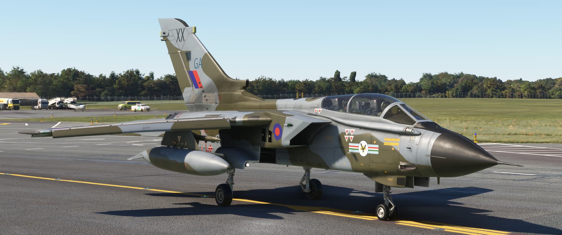
Pee-Wee says: I sure am! You can choose our ride this time. We’ll need something fast that’s also maneuverable and efficient down low, and that looks awesome.

Is that last part really a requirement?

Pee-Wee says: My man doesn’t fly ugly airplanes.

I flew Jetstreams.

Pee-Wee says: My man doesn’t fly ugly airplanes anymore. :smirking_face:

Thanks for tuning in, everyone! Hopefully you learned something interesting today. Look for Parts 2 and 3 soon, and remember to keep the blue side up, have plenty of fuel in the tanks, and avoid the red guarded switches.

Pee-Wee says: Bye for now! :face_blowing_a_kiss:

4 Likes

Pee-Wee and Nag over Northumberland and Cumbria

Hadrian’s Wall, Part 2


Welcome back, everyone! In this second part of our Hadrian’s Wall tour, we’ll look at the wall’s design and construction, and specifically the parts you’ll see in MSFS.

Pee-Wee says: Think of this as your primer for Part 3. :blush:


Pee-Wee says: Nag did, in actual fact, choose an awesome looking airplane! This is Tornado GR.1 ZA399, the 66th British-built airframe. She flew twenty-four missions over Iraq and Kuwait during Operation Granby and appears here as she did in 1992 during 20 Squadron’s disbandment parade. Her “nameplate” crew—Squadron Leader Batson and Wing Commander Heath—flew together during Op Granby, notably scoring an aerial “kill” using the JP233 airfield denial weapon (not in this aircraft).

Notice anything unusual about her markings? If you said “golly, Pee-Wee, her squadron badge is where the RAF roundel should be, and the roundel is on the intake,” you’re correct, you eagle-eyed mega nerd. :blush: 20 Squadron received special permission for the change in 1989.

ZA399 was later modified as a specialized anti-ship GR.1B and served until 2001 with 617 Squadron at RAF Lossiemouth. Restored by Jet Art Aviation, she was displayed at RAF Cosford and then outside Oliver Valves in Knutsford, Cheshire, but has apparently been relocated recently. Does anyone know where she went? :thinking:

You can thank talented texture artist lowlevelRAF at flightsim.to for this excellent skin.

Here’s the waypoints for this tour. We were new to the IndiaFoxtrotEcho Tornado, so we strapped on two 1,500-gallon (5,678-liter) tanks. They weren’t necessary, but you can never have too much gas!

Waypoint Coordinates Lat/Long (Skyvector)
Milecastle 30 / Procolita 55.0378 -2.1985 550216N0021155W
Milecastle 33 / Shield on the Wall 55.0300 -2.2698 550148N0021611W
Milecastle 42 / Whin Sill 54.9953 -2.4340 545943N0022602W
Milecastle 50 / Turf Wall 54.9858 -2.6185 545909N0023706W

 
Alright, that’s enough talking. Ready back there?

Pee-Wee says: Pen, paper, panties, popcorn. All set. :+1:

Uh…roger that.


:one: Hadrian’s Design

Pee-Wee did most of the research for this tour, so I’ll let her handle this part.

Pee-Wee says: Move over. :blush: Okay, let’s start with the basics. There are five parts of Hadrian’s Wall you can see in MSFS with TMD’s HW180 installed.

The Wall itself was built with shaped stones and stood roughly 15 feet (4.6 meters) tall and either about 8 or 10 feet (2.4 or 3.0 meters) wide, with the earliest built portions being widest. It was likely topped with a curtain wall, embrasures, and a wall-walk, and may have been limewashed white. If you don’t have the HW180 scenery, look carefully in MSFS’s base scenery and you’ll see the wall’s ruins.

The V-shaped Wall Ditch ran parallel to the wall’s north face. It was roughly 28 ft (8.5 m) wide and 9 ft (2.75 m) deep, possibly filled with obstacles (i.e. “sharp, pointy things”), and ran the full length of the wall except in areas where natural obstacles like the crags of the Whin Sill made it unnecessary. Portions of the ditch are visible in MSFS’s base scenery.

The Milecastles were small forts built every Roman mile (about 0.9 statute miles or 1.5 kilometers) along the wall’s length. They had entry gates to the north and south and were manned by 12 to 20 soldiers.

Between the milecastles were two evenly spaced 30-foot (9-meter) tall Turrets, each manned by four to six soldiers.

Large Forts were built roughly every seven Roman miles (6.5 statute miles, 10.4 kilometers) along the wall. About 600 soldiers were stationed at each fort.

Each fort fostered a surrounding civil settlement called a Vicus. Only those at Verovicium and Vindovala (modern Housesteads and Rudchester) are included in HW180. The remainder will be added in a future update.

The Vallum was an earthwork south of the wall. It was basically an obstacle, a “super ditch” 20 ft (6 m) wide and 10 ft (3 m) deep and bounded by mounds. Causeways crossed the vallum at each fort. Like the wall ditch, portions of the vallum are visible in MSFS’s base scenery.

A road—the Military Wayran atop the northern mound or across the land between the vallum and the wall.

The distance between milecastles, turrets, and forts didn’t vary unless necessary due to the terrain. Regardless, the spacing meant that anyone attempting to sneak across the frontier was never more than about 900 ft (274 m) from Roman soldiers.


Pee-Wee drew this schematic showing the wall’s general arrangement. (PW says: Not to scale!) The vallum is highlighted yellow. It was approximately 100 feet (30 meters) wide and was built between 100 and 2,300 feet (30 and 700 meters) south of the wall.


Here we are flying west in the vicinity of Chesters house and the village of Walwick. The guys at TMD blended the wall into the existing scenery perfectly! Notice that the spacing of the milecastles and turrets is unaffected by the intrusion of Procolita (modern Carrawburgh): MC.31 is within spitting distance of the fort! Also notice how the vallum doesn’t exactly parallel the wall near MC.30.

Pee-Wee says: The pattern of one milecastle and two turrets repeated along the wall’s entire length in a pattern that TMD’s team and other users have referred to as “hypnotic!” :sleeping_face:


:two: Construction

Three Roman Army legions—approximately 16,000 men—were tasked with building Hadrian’s Wall: Legio II “Augustus” from Isca (modern Caerleon, Newport, Wales), Legio VI “Victrix” from Eboracum (modern York, North Yorkshire, England), and Legio XX “Valeria Victrix” from Deva Victrix (modern Chester, Cheshire, England). Work began in 122 AD and was completed by 128 AD.

Pee-Wee says: Roman legions were divided into ten cohorts, and each cohort was further divided into six centuries. Think of a legion as a modern regiment, a cohort as a battalion, and a century as a company.

The original stone wall stretched from the River Tyne at Wallsend near Newcastle to Milecastle 49 near Gilsland, with a turf wall continuing west to Bowness-on-Solway. The turf wall was rebuilt with stone sometime between 160 and 180 AD.


Pee-Wee says: The guys at TMD assigned an architectural style to each legion as seen in the photo above, then determined which legion built each turret, milecastle, and fort. The legions shared the construction work, so you’ll see all three styles along the wall’s entire length.

Now that’s a fanatical commitment to accuracy.

Pee-Wee says: It sure is. Hey, wanna’ keep the jet out of the way? I’m trying to type here. :smirking_face:

Just providing some scale. :grinning_face:


:three: Overview


Pee-Wee says: We’re in the vicinity of (1) Shield on the Wall Dam and (2) MC.33, one of several excavated milecastles visible today. In the distance is (3) Verovicium (modern Housesteads), the ruins of which have been extensively excavated and are open to the public today. The wall ditch, vallum, and even portions of the Military Way are visible along this stretch. The guys at TMD did a masterful job of removing the B6318—the “Military Road”—which follows the wall’s path here. This looks like a good place to stop in Part 3. :blush:

The Military Road (not to be confused with the “Military Way”) was built between 1751 and 1758 to facilitate the movement of military forces between Newcastle and Carlisle, and runs for long stretches atop the remains of Hadrian’s Wall. Only the road’s divergence southward west of MC.33 at Sewingshields saved the remainder of the wall from destruction.


Pee-Wee says: We’ve flown further west along the Whin Sill to MC.42 in this east-facing photo. With the wall built atop the (1) towering crags, there was no need for a wall ditch. (2) Here is the Military Way, slightly uphill from the (3) vallum. This (4) modern road cuts across the vallum, much like the causeways built by the Romans. Here’s the (5) B6318 again.


Pee-Wee says: Finally, here we are flying over (1) MC.50 west of Camboglanna (modern Castlesteads). When the Romans rebuilt this portion of the wall with stone, they generally followed the original turf wall’s course, but not always. Here you can see (2) the approximate location of a turf milecastle, (3) the vallum, and (4) a portion of the turf wall running to (5) MC.51.
 

Now that our readers know what to look for, let’s slip into something more appropriate for low and slow viewing, shall we?

Pee-Wee says: I can think of a few options. Mind if I pick?

Not at all.

Pee-Wee says: By the way, everyone, Part 3 will be a little delayed. This weekend we’re heading to Oregon to see The Evergreen Aviation & Space Museum for Nag’s birthday, and he’s agreed to take me to…[gasp]…oh, be still my beating heart… :face_holding_back_tears:

Yes, first we’ll visit the Tillamook Air Museum, which if you’re unaware, is housed within the remaining blimp hangar at former Naval Air Station Tillamook. And, if you haven’t figured it out already, Pee-Wee really likes blimps and airship hangars.

Pee-Wee says: Really really.

Obsession.

Pee-Wee says: Probably.

Weird.

Pee-Wee says: Shuddup. :smirking_face: Hey, everyone! Here’s a test of your reading comprehension: why did Nag choose that specific Tornado skin for this tour? The first person to answer correctly will win two amazing prizes: bragging rights and my admiration (no cash value). :blush: Sorry, Mr. Pips, you’re excluded!

Thanks for tuning in, everyone. Part 3 will drop later in June.

Pee-Wee says: Bye for now! :face_blowing_a_kiss:

4 Likes

Great part 2 as always guys. Was the skin selected due to the “XX” on the tail for squadron 20 and the connection to Legio XX?

I’m also planning a trip to Oregon to go to WAAM, Evergreen and hopefully Tillamook. Or rather I should say my wife is planning it for our anniversary in March. Really would love to see that beautiful blimp hangar. And the Spruce Goose is at Evergreen and that’s worth seeing for sure.

Thanks for the history lesson. Happy flying!

1 Like

Pee-Wee says: We have a winner! (Of course, you’re the only one who played. :smirking_face:) You’re exactly right, MaverickKing: 20 Squadron, Legio XX. Well done!

We’re home from our Oregon museum adventure, and what a trip it was. We spent four hours at the Tillamook Air Museum, which was even more impressive than I imagined! You definitely need to swing by on your trip in March, or sooner if able. So many of these hangars have been lost, I spent the night before praying “please don’t burn down, please don’t burn down, please…”


If you look carefully, you’ll find Pee-Wee somewhere in this photo. When you visit, bring a jacket: there’s no air or heat inside the hangar, and it was a good 10 to 15 degrees Fahrenheit cooler inside than outside.

And the next day…


We were the only two people on our “flight deck” tour! It was supposed to last 15-minutes, but since it was early on a Monday morning, we got the unofficial 90-minute version. The fact that our guide was a retired pilot and Pee-Wee is an outgoing woman who likes talking “mechanical stuff” probably helped!

Pee-Wee says: You’re welcome. :blush: BTW, we plan to return to Evergreen, so we purchased the basic membership, which among other benefits includes admission and a tour-for-two of the Spruce Goose. Doing that reduced the day’s cost from $102.66 to $85.


Anyway, friends, we’ll need some additional time for Part 3 of the HW tour. Nag is due for his annual recurrent training in July and needs to spend most of his time reviewing and studying, so I’ll be flying mostly solo, and I only type so fast.

Thanks again for your compliments, everyone!

Pee-Wee says: Mmm, positive reinforcement! :blush: :two_hearts:

3 Likes

Well I suppose it’s pretty easy to “win” when you’re the only player. :joy:

My goodness, it’s beautiful! That hangar is so cool and now I can’t wait to see it in person. And the beautiful Spruce Goose. I’ve heard that you really aren’t prepared for the sheer size of that aircraft. Thanks for sharing those pictures.

Looking forward to part 3 of Hadrian’s Wall.

2 Likes

Pee-Wee says: Whoops! I didn’t mean to post yet. Stay tuned! :flushed_face:

Pee-Wee and Nag over Northumberland and Cumbria

Hadrian’s Wall, Part 3


Welcome back, everyone! Let’s take a closer look at Hadrian’s Wall and the countryside it traverses.

Pee-Wee says: For this final part of our tour, I chose FlyBoy Simulations’ awesome light sport Rans S6S.

It was a bad choice.

Pee-Wee says: Unfortunately, it was. She’s well-built and flies wonderfully—she’s one of my favorite GA aircraft for MSFS—but her takeoff performance is somewhat lacking.

Totally lacking.

Pee-Wee says: I agree that compared to other GA singles, her takeoff performance is more akin to that of a copy machine than an airplane, but we managed without too much drama, although we did clip some bushes on occasion.

And ricocheted off a building.

Pee-Wee says: That’s why we fly with crash detection turned off. :innocent:

You hit the Sycamore Gap Tree, for heaven’s sake.

Pee-Wee says: Shouldn’t you be studying?

Next time, let’s take the Zenith.

Pee-Wee says: Immediate action items. Limitations. The AOM Non-Normal Chapter. Go study.

Yes, dear. :smirking_face:

Pee-Wee says: Sheesh. Crash into one national landmark and he never lets you hear the end of it. :wink: Anyway, here are the tour waypoints. We started at Kirkbride Airfield about 10 miles (16 kilometers) west of Carlisle. The runway there is 4,200 feet (1,280 meters) long. If you need a longer runway, you can use Carlisle, although you’ll have to backtrack to the first few waypoints.
 

Waypoint Coordinates Lat / Long
Milefortlet 21 54.7467 -3.4505 544448N0032702W
Alauna 54.7209 -3.4938 544315N0032938W
Maia 54.9529 -3.2146 545711N0031253W
Dixon’s Chimney 54.8918 -2.9453 545331N0025643W
Carlisle Cathedral 54.8948 -2.9385 545341N0025618W
Carlisle Castle 54.8972 -2.9420 545350N0025631W
Petriana 54.9040 -2.9343 545414N0025603W
Houghton 54.9180 -2.9123 545505N0025444W
Pike Hill Signal Tower 54.9760 -2.6630 545834N0023947W
River Irthing Bridge 54.9913 -2.5920 545929N0023531W
Milecastle 48 54.9890 -2.5735 545920N0023425W
Gilsland 54.9913 -2.5724 545929N0023421W
Turret 40A 55.0016 -2.4072 550006N0022426W
Peel Gap Tower 55.0013 -2.3872 550005N0022314W
Sycamore Gap Tree 55.0036 -2.3739 550013N0022226W
Turrets 37A & B 55.0108 -2.3496 550039N0022059W

 
Waypoints in italics require installation of Orbx’s EU Great Britain North. Below are the additional scenery addons you’ll need to see things the way we did.

Scenery Author Payware
Hadrian’s Wall 180 Time Machine Designs Yes
EU Great Britain North Orbx Yes
We Love VFR - Region 1 PuffinFlight No
Sycamore Gap Tree Maxest No
Ethnicfs Vegetation Library ethnicFS No

 
Alright, let’s buckle up and hit the road! :slightly_smiling_face:


:one: We Could Just Go Around: Maia and the Western Coast Defenses

Pee-Wee says: I know what you’re thinking: “What was stopping anyone from going around the wall?” Well, the Romans thought of that, too. To the west of Bowness-on-Solway, they built what we today call the Western Coast Defenses, which looked an awful lot like the original turf Hadrian’s Wall without the actual wall. Wooden and turf “milefortlets” and turrets were built along the Cumbrian coast south to Maryport and may have been connected by a vallum or trench. Very little of the Western Coast Defenses remains intact, although Milefortlet 21 and the old fort Alauna are visible in MSFS. Since the focus of this tour is TMD’s HW180 addon, they’re not included here.


Here we are turning east over (1) National Cycle Network Route 72, a.k.a. “Hadrian’s Cycleway.” The first portion of the NCN was established in 1984 between Bristol and Bath, and today the web of paths and roadways spans 12,739 miles (20,501 kilometers) across the entire United Kingdom.

To the north is the (2) Solway Firth flowing southeastward toward (3) Carlisle. Against the shoreline is (4) Maia, the westernmost and second largest fort on Hadrian’s Wall. While the forts and milecastles use the same 3D building models, the guys at Time Machine Designs used actual diagrams and excavation reports to recreate each individual fort’s, milefort’s, and turret’s layout as it would have been in AD 180.

These (5) two turrets represent those along the Western Coast Defense line, which is not modelled in the HW 180 scenery addon.

Nag’s Study Break #1: The fact that one could so easily bypass Hadrian’s Wall further strengthens the argument that the wall wasn’t a fixed defensive position, but rather a semi-porous dividing line between controlled and uncontrolled areas.


:two: The Opposite of Bliss: Carlisle

Pee-Wee says: Here’s Carlisle, or Lugavalium as it was called in AD 72 when the first timber fort was built here. Part of the earlier Stanegate frontier, Lugavalium morphed into the one of the largest settlements along Hadrian’s Wall and was a major supply port on the River Eden.


Here we are flying northeast over (1) Petriana. Built in AD 130, the fort was the largest along Hadrian’s Wall. Today this fort lies buried beneath the Carlisle suburb Stanwix (Old English: “stone wall”).

The (2) River Eden was known as Itouna in Roman times, and formed a natural barrier for the fort at Lugavalium, the site of which lies mostly beneath (3) Carlisle Castle. Constructed under William II of England in 1091 and rebuilt by Henry I of England with stone in 1122, Carlisle Castle protected the Anglo-Scottish border for nearly 700 years until shortly after the Jacobite Rising of 1745. Today it’s open to the public and hosts Cumbria’s Museum of Military Life.

In the distance you can see the 900-year-old, Grade I listed (4) Carlisle Cathedral, the 288-foot (90-meter) Grade II listed (5) Dixon’s Chimney, and the (6) windmills at Watchtree Nature Preserve. The cathedral started life as a Norman Priory in 1122 and became a cathedral about ten years later. Today it boasts a wonderful 4-manual, 72-stop, 4,000-pipe organ built by famed designer Henry Willis, a choir that’s been performing since at least 1541 (don’t worry: they’ve stopped for restroom breaks), and a peal of 13-bells that still ring daily. The nearby Dixon’s Chimney dates to 1836. It was once the eighth tallest chimney in the world and served the neighboring Shaddon Mill, the largest cotton mill in England at that time. Today, the mill is an upscale apartment complex and Dixon’s Chimney the city’s most prominent restored landmark.

The Carlisle Castle, Cathedral, and Dixon’s Chimney are all part of Orbx’s EU Great Britain North scenery addon.

Nag’s Study Break #2: Historic or architecturally important buildings and sites in England are “listed,” and may not be demolished or modified without explicit permission. Those of special interest, like the Abbey Road recording studio and Croydon Airport, are listed Grade II, while those of important special interest, like the Brighton Palace Pier and Stoke-on-Trent railway station, are listed Grade II* (pronounced “Grade Two Star”). The most important locations, like the Palace of Westminster and Tower Bridge, are listed Grade I. Of the approximately 380,000 listed buildings in the UK, 2.5% are Grade I and 5.8% are Grade II*. Thousands of houses in England are Grade II listed or higher, and owners must apply for permission to make even minor alterations. Violators may receive a two year prison sentence and an unlimited fine.
 
A similar system is used in Scotland.


:three: What’s In A Name?: Houghton

Pee-Wee says: Many places along the wall’s path draw their names from Roman history, like the villages of Walltown, Walwick and Little Walwick, Heddon-on-the-Wall, Oldwall, and Walbottle. The wall’s eastern terminus is in creatively named Wallsend. All along the wall’s path you’ll find road names like Vallum Road and Hadrian Place in Throckley, Trajan and Antonine Walks in Heddon-on-the-Wall, and Hadrian Court in Humshaugh. In Newcastle there’s West Gate Road which ends curiously close to where Pons Aelius’s west gate would have been.


Here we are following (1) Bampton Old Road toward (2) the M6 in the vicinity of Houghton, where you’ll find Hadrian Way, Antonine Way, Tribune Drive, and Eagle Way. (3) This park is named Hadrian’s Park and is reached via (4) Hadrian’s Gardens and (5) Centurions Walk.

For thirty years, the Royal Army operated an artillery, armor, and engineering apprentice school here named Hadrian’s Camp. It was replaced in the 1970s by a (6) police motor pool and (7) Hadrian’s Caravan Park. The park gained notoriety in 2018 when one of its residents, Peter Swailes, Sr., was arrested and charged with violating the Modern Slavery Act of 2015. Inside a wooden shed behind Swailes’s static caravan, police discovered a 58-year-old mentally handicapped man living in squalor, who Swailes had been exploiting for 40 years. (Really? None of the neighbors noticed? :unamused_face:)

Unfortunately, Swailes passed away before justice could be served. Thanks to a national charity, the victim now lives freely in a safe house somewhere in England.


:four: Operator, Long Distance Please : Pike Hill Signal Tower

Pee-Wee says: Approaching MC.57 and the village of Castlesteads, the wall enters hill country and begins climbing steadily toward its highest elevation at Winshields Crags sixteen miles (26 kilometers) to the east. There’s one important point along this stretch of wall that’s not visible from the air: between MC.54 and T.53B lurks the Wem–Bridgemere–Red Rock Fault System. There is a complete absence of limestone west of this line…which is why the wall switched from stone to turf a few miles to the east at MC.49. Ooh! Geology meets engineering! :grinning_face:

Hadrian’s Wall wasn’t Rome’s first frontier across Britannia. The Stanegate (Northumbrian: “stone road”) was a roadway running between modern Newcastle and Carlisle which was built nearly fifty years before Hadrian’s Wall. Several fortifications and towers were built along the road, and some of those were incorporated into Hadrian’s Wall around AD 125, including the signal tower atop Pike Hill. Researchers believe the tower was one of several linking the Stanegate forts.


Pee-Wee says: Here we are flying east past the Pike Hill Signal Tower between MC.52 and T.52A west of the fort at Nether Denton and near the modern village of Banks in Cumbria. Two other towers are located north of the fort at Vindolanda, near the village of Bardon Hill, and researchers believe that others remain to be discovered.

Milecastle 52 (visible between our Rans’s landing gear) is the largest along Hadrian’s Wall, which may indicate a larger garrison to man the Pike Hill Tower.


:five: Where Stone and Turf Meet: River Irthing Crossing

Pee-Wee says: Hadrian’s Wall crossed the River Irthing just east of MC.49 where the original stone wall ended and the turf wall began. The first stone arch bridge here was washed away around AD 160 and was replaced by the stone and wooden structure seen in the HW180 scenery addon, which was itself replaced by a wider road bridge some twenty-five years later.

Rivers have a funny way of changing course over time, and the River Irthing today flows through this valley some 220 feet (67 meters) further west than in Roman times, leaving the remains of this ancient bridge high and dry in the sheep-filled paddock beyond. The bridge in HW180 is accurately placed: the guys at TMD moved the River Irthing back to where it was nearly two Milenia ago!


Here we are in the paddock southwest of the Irthing Bridge. Today this spot is known as Willowford, and the Hadrian’s Wall Path crosses just downstream on a modern metal bridge.

Look closely at the wall’s “front face” and you’ll notice red “grout lines.” That’s not a display error! There is some indication that at least some of the wall may have been dressed so and may even have been partially rendered with lime. It’s another nice detail from the guys at TMD. :+1:

Nag’s Study Break #3: Shout out to the troops who rendered 72 miles of wall, and to the Admin Centurions who handled their worker’s compensation claims. :wink:


Pee-Wee says: Hey…guess what, everyone?

In the United States, airline pilots must complete “recurrent” classroom and simulator training annually. The month in which a pilot is due for training is their “base” month, but the training may be completed one month early or late in the “grace” months. My base month is July, but I just found out that I’ll be going to training “grace month late” in August, which means…

Pee-Wee says: Which means I get my writing buddy back. Yay! :blush:


:six: A Railway Runs Through It: Gilsland

Pee-Wee says: And now I get to talk about trains? Can this day get any better? :grinning_face:

Hold your horses. Let’s talk about this village and the milecastle, first.

Pee-Wee says: Okay, but write fast.

Gilsland lies astride the River Irthing in both Cumbria and Northumberland. The village was, during the 19th Century, four separate hamlets: Gilsland on the Irthing’s west bank in Cumbria, and Rose Hill, Mumpshall, and Crooks on the east in Northumberland. Sometime between 1838 and 1860 the four hamlets merged to become the village we see today.

For decades farming and mining were the largest industries here, but today, nearly one quarter of Gilsland’s population of 400 works in the tourist and hospitality industry. The village boasts at least five large bed and breakfast resorts and other amenities catering to the nearly 400,000 tourists, hikers, and cyclists that pass through here annually.


Southwest of the village is (1) MC.48, also known as Poltross Burn Milecastle (after the stream that flows beside it) and the King’s Stables. This milecastle was built on a much steeper slope than any other: look closely and you’ll see that the barracks blocks are terraced.

If you have PuffinFlight’s We Love VFR Region 1 installed, you’ll see this (2) tower rising from the village. It’s not there in real life and not marked on any navigation charts, so watch out! In the distance, Hadrian’s Wall (3) continues east and begins its climb up the Whin Sill near the Stanegate fort Magna.

Regional and local bus operator Go North East’s Hadrian’s Wall Country Bus runs daily from Hexham to Vindolanda, Vercovicium / Housesteads, Cilurnum / Chesters, the Roman Army Museum / Magna at Walltown, and numerous points in between. The service no longer serves Gilsland, but Walltown is only an hour’s walk away via the Hadrian’s Wall Path. The bus is very cleverly numbered AD122.

Okay, you can talk about trains now. I’m going to make us dinner.

Pee-Wee says: Ooh. This day can get better! :wink: In the photo above you’ll notice what appears to be a railway running into the wall. That’s the (4) Carlisle-to-Newcastle Tyne Valley Line, operated by commuter railway Northern Trains. The line sees at least two passenger trains per hour in each direction between Carlise and Hexham, and three per hour eastward to Newcastle. Total travel time end to end is about one hour and forty minutes.

Northern uses a mix of ageing-but-refurbished Class 156 and Class 158 diesel and diesel-hydraulic multiple unit trains. (For our American friends, think MU’ed diesel railcars.) Freightliner mixed and unit trains hauled by Class 66 diesels make occasional appearances.

Built as the Carlisle and Newcastle Railway between 1834 and 1838, the 58-mile (93-kilometer) double-tracked line changed ownership numerous times and is today owned by national infrastructure provider Network Rail, and will presumably transition to Great British Railways whenever that white elephant is born.

Hey, it might work.

Pee-Wee says: Let’s be honest: the British Government has a way of cobbing things up. :smirking_face: By the way, adorable YouTube train enthusiast and vlogger GLovesTrains posted a video in which she not only rides aboard Northern on the Tyne Valley Line, but also hikes the Hadrian’s Wall Path along the Whin Sill. Go check her out!


:seven: The Nosebleed Section: Turret 40A


Here we are flying east past Turret 40A atop Winshields Crags. At 1,135 feet (345 meters) above sea level, this is the highest point along Hadrian’s Wall. A stone tower with a veranda and 360-degree views of the beautiful English countryside? Not a bad duty station, if you ask me!
 

:eight: Hadrian’s Blind Spot: Peel Gap Tower

Pee-Wee says: So, you’re flying along the wall, enjoying the scenery, and counting steadily…“milecastle, turret, turret, milecastle, turret, turret, milecastle, turret, turret, turret, mile…whoa…hold up…” :face_with_raised_eyebrow:

The Romans were loath to break the pattern of one milecastle and two turrets each mile along the tower but would make adjustments, when necessary, such as at Peel Gap in western Northumberland. Architects and planners realized that, because of the placement of Turrets 39A and 39B, enterprising invaders could approach the wall unobserved through Peel Gap between Winshields and Peel Crags and Hound Hill. Their solution? Add another turret, of course!


Pee-Wee says: (1) Here’s Peel Gap with its extra turret between (2) T.39A atop the Peel Crags and (3) T.39B atop the Winshields Crags. (4) Hound Hill lies beyond. Look carefully and you’ll see the (5) Military Way, which is overlaid by (6) this portion of modern road.

The guys at TMD removed the (7) Peel Cottage which stands just southwest of the Tower. Built in the 1850s and dedicated by the Queen Mother herself, the cottage is managed by the National Trust and accommodates two people and two dogs in 3-acorn comfort. It looks like a great “home base” if you’re exploring the wall, especially since the well regarded Twice Brewed Inn is only a stone’s throw away! But be warned: reservations are hard to come by (the earliest currently available are for November), and each night will cost you about £540 ($737). Jiminy Christmas! :flushed_face:


:nine: A Tale of Two ■■■■■■■: The Sycamore Gap Tree

You know, I’ll give the forum’s censoring algorithm that one. That wasn’t a very nice word.

Pee-Wee says: Sorry, but this story really gets my goat, and I’m very protective of my goat. :enraged_face:

If you’ve installed Maxest’s scenery, you’ll find the iconic Sycamore Gap Tree approximately one mile east of the Peel Gap turret. This lonely tree became world famous after its brief appearance in Kevin Costner’s 1991 film Robin Hood: Prince of Thieves, and was voted the United Kingdom’s Tree of the Year in 2016.

Pee-Wee says: Lawyer and Newcastle town clerk John Clayton inherited the land upon which the Roman fort Cilurnum stood in 1832, and eventually purchased another four forts and twenty miles (32 kilometers) of land along the wall. A keen antiquarian and archaeologist, Clayton spent fifty years excavating, researching, and preserving the wall’s remains. He planted this non-native Sycamore tree here as a landscape feature sometime between 1832 and 1860.


He we are buzzing the Sycamore Gap Tree in this north facing photo. In Robin Hood, Costner and costar Morgan Freeman climb up the remains of Hadrian’s Wall to the left. (The scene was filmed facing south from the other side of the wall.)

In the early hours of 28 September 2023, the Sycamore Gap Tree was intentionally felled by unknown persons using chain saws. Investigators later arrested thirty-something-year-old friends Adam Carruthers and Dan Graham of Carlisle and charged them each with two counts of Criminal Damage to the tree and wall.

Pee-Wee says: I can’t say enough bad things about these two bellends. Thankfully, they’re as stupid as they look: as word of the vandalism swept the world, the dolts both bragged and sent incriminating photos and videos to each other via their traceable and subpeonable cell phones. As you would expect, the hoodlums turned on each other when presented with nearly unequivocal evidence of their guilt. Both were found guilty in May 2025 and will be sentenced later this month. Each could face up to a decade in prison. (What emoji do I use for “anxiously wringing my hands in anticipation of some idiots’ imminent downfall?”)

Breathe, Honey. :smirking_face:

Thankfully, the tree’s trunk shows signs of life today, and numerous cuttings from the original survive around the United Kingdom. Regardless of the efforts of those two Cumbrian losers, the Sycamore Gap Tree will live on.

Fun fact: Horses are social animals, and keepers often pair goats with lonely racehorses. Separating the unlikely companions usually causes the horse irritation or anger. So, if someone “gets your goat,” they metaphorically take your goat away, leaving you irritated and angry. :goat:


:ten: Wall on a Wall: The Whin Sill


Pee-Wee says: Here we are trimming the grass on the north side of Hadrian’s Wall and the Whin Sill, with Turrets 37A and 37B behind. Milecastle 37 and Vercovicium / Housesteads auxiliary fort are just out of frame to the left.

Hadrian’s Wall generally follows the Stanegate’s course, but the Romans deviated north to the Whin Sill to leverage the towering crags’ great height. Who needs a wall ditch when you can have a 230-foot (70-meter) cliff? And, yes, the forts and milecastles along the sill have doorways opening onto the cliff. Watch that first step!

Pee-Wee says: The Whin Sill was formed roughly 295 million years ago when tectonic movement smashed the ancient continents Euramerica and Gondwana together into the super continent Pangea. During the collision, stretching and thinning of Earth’s crust in northern England allowed the injection of hot magma from deep within the planet between existing layers of sedimentary rock, which cooled and became a dark igneous whinstone known as dolerite. Millennia of erosion slowly removed the surface soil and exposed the towering crags we see today.

English quarrymen used the word “whin” to describe “dark, hard rock” like the dolerite of the Whin Sill. Confusingly, whin is also the Middle English word for thorny, yellow flowering gorse bushes, and appears in place names like Thorpe Whin in East Riding of Yorkshire, Whin Burn in Aberdeenshire, and Whin Fell in Cumbria.
 
The quarrymen used the word “sill” for flat, horizontal rock formations like the Whin Sill because of their resemblance to stone windowsills. When geologists learned the mechanism by which the Whin Sill was created, they adopted the word “sill” for any sheet-like body of igneous rock formed when magma intrudes between layers of existing rock.
 
Whin Sill means “dark, hard horizontal rock formation created by magma intrusion.”

Whew! That was a lot of geology, which really isn’t my thing. My head hurts. :exploding_head:


Hmm. That’s ten photos, the forum limit. I suppose we’ll have to continue with an unplanned Part 4! We already have the research and much of the text done, so it should be posted soon. Thanks for tuning in, everyone!

Pee-Wee says: See ya’ soon! :face_blowing_a_kiss:

4 Likes

Pee-Wee says: Hey, everyone! We just noticed that TMD’s HW180 scenery is included in the MSFS Marketplace’s Summer Sale. If you’ve been holding out, now would be a good time to purchase. We’ve found the addon surprisingly interesting and informative, and we always enjoy helping up-and-coming developers.

(Let me say again that Nag and I aren’t affiliated with TMD and receive no compensation or consideration. We just thought you all might want to know! :blush:)

If all goes well, we’ll post Part 4 of our HW tour by Thursday evening. Stay tuned, and thanks for your support! :face_blowing_a_kiss:

1 Like

Pee-Wee and Nag over Northumberland and Cumbria

Hadrian’s Wall, Part 4


We’re into the final stretch, everyone! Here’s the points we’ll visit in this final part of our Hadrian’s Wall tour.

Waypoint Coordinates Lat/Long
Turret 33B 55.0294 -2.2791 550146N0021645W
Cilurnum (Walwick Chesters) 55.0260 -2.1394 550133N0020822W
Denton West 54.9855 -1.6967 545908N0014148W
Condercum (Benwell) 54.9768 -1.6643 545837N0013952W
Wallsend 54.9857 -1.5273 545909N0013138W
Rough Castle Fort 55.9980 -3.855 555953N0035120W

 
Pee-Wee says: Listos? Vamos a pasar! (Gah! Flashbacks to high school Spanish class! :wink:)


:one: Up Close and Personal : Turret 33B

Pee-Wee says: Let’s take a look at the Hadrian’s Wall frontier from ground level. We landed near T.33B in the space between the vallum and the wall, which was a little rough. (Nag says: Very rough!) You should probably land further away, perhaps south of the vallum.


We’re facing east in this photo, looking at (1) T.33B. You can just make out (2) Brocolitia in the distance, approximately three miles away. North of the wall is the (3) spoil mound (with the Hadrian’s Wall Path atop) and the (4) wall ditch. South of the wall you can still clearly discern the vallum’s north and south mounds, and what may be a portion of the (5) marginal mound.

Pee-Wee says: According to the latest press release, TMD’s forthcoming update to HW180 will include not only the vici but some other Roman structures and the vallum.


:two: The Ultimate Landscape Project: Cilurnum (Walwick Chesters)

Cilurnum, known today as Walwick Chesters or simply Chesters, was built in approximately AD 124. The additional entryways on the north wall reveal Cilurnum’s original role as a cavalry fort. Two auxiliary units–the Yugoslavian Cohors I Delmatarum and the German Cohors I Vangionum Milliaria Equitata–are known to have served here.

Pee-Wee says: The Romans rarely adjusted the spacing of the mileforts and turrets, which resulted in some odd configurations: MC.31 is only a few hundred feet from Brocolitia, and T.21A is awfully close to Onnum. Five forts supercede a milecastle or turret completely. When this site was chosen for Cilurnum, the unfinished T.27A already under construction here was demolished and not replaced. Today, only the turret’s clay and cobble foundation remains immediately northeast of Cilurnum’s principia.

Other locations where a fort supercedes a milecastle or turret are: Vercovicium (T.36B), Aesica (MC.43), Camboglanna (T.49A), and Aballava (T.71B).


We’re flying northeastward over (1) Cilurnum and the (2) stone bridge across the River North Tyne. A thriving vicus once neighbored this fort, and today it’s (3) bath house is one of the most complete and best preserved in all the Roman Empire.

The guys at TMD removed the Chesters county mansion, once home to antiquarian and famed Hadrian’s Wall protector John Clayton (see Part 3). It was built on the high ground west of the fort almost 1,600 years after the wall’s completion. Clayton excavated large portions of Cilurnum and uncovered hundreds of artifacts, many of which are displayed today at the collocated museum. In MSFS you can see the (4) modern fence which surrounds the site and the Grade II* listed (5) Clayton Museum and access path. (The country house visible near the tree line in MSFS is actually a small shed.)

Pee-Wee says: If you’re in the area, be sure to visit the nearby village of Wall. (Ah, those clever British place names. :grin:) There you’ll find the Roman Stones Cottage self-catering accommodation and a tour company that provides guided walking tours along the wall.

Pee-Wee says: British aero engine manufacturer Rolls-Royce named its piston engines for birds of prey (Griffon, Peregrine, Vulture) and its turbines for rivers (Avon, Trent, Spey). The RB.109 Tyne turboprop powered the Vickers Vanguard, Shorts Belfast, and Canadair CL-44, and remains in service today on French Breguet Atlantiques and Turkish Transall C-160s. The RM1 and RM3 maritime versions powered the Royal Navy’s Amazon and Broadsword-class frigates and Sheffield-class destroyers.
 
Now admit it: you thought the most famous piston engine of all—the Merlin—was named for the wizard. :smirking_face:


:three: Ancient History Meets the Commuter Belt: Denton East

Denton East was a distinct township and civil parish until merging into Newburn and Newcastle-upon-Tyne. Interestingly, Rev. John Wilson’s 1870 Imperial Gazetteer of England and Wales describes Denton East as: “a township in Newburn parish, Northumberland; on the Roman wall, 3½ miles WNW of Newcastle-upon-Tyne.”


Pee-Wee says: It appears we’ve teleported to Cold War-era Berlin in this photo, but we’re actually flying roughly southeastward over Denton East in the outskirts of Newcastle. The guys at TMD excluded the modern scenery along Hadrian’s Wall, creating a “no man’s land” reminiscent of East Germany’s notorious Berlin Wall.

Want to see Hadrian’s Wall for real but can’t venture out into the country? Newcastle is the place to go! (1) This 75-foot (23-meter) portion of wall is visible today on the southeast corner of the intersection of the A69 and Southway Road outside (2) The Ramparts housing development. When the Ordnance Survey mapped Hadrian’s Wall in 1964, this was the easternmost visible portion of wall.

Across the (3) A1 highway you’ll find (4) Turret 7A. This portion of wall, including the turret’s base, are also visible today along Turret Road.

Pee-Wee says: Turret Road?

Yup.

Pee-Wee says: I’m surprised we haven’t found a road called “Road” yet. :roll_eyes:

Hold that thought…


:four: The Home Stretch: Condercum (Benwell)

Pee-Wee says: Condercum was built by Legio II around AD 124 with assistance from a Roman British Fleet detachment, and was once home to the 1,000-man Cohors I Vangionum Milliaria Equitata, a German auxiliary foot and horse infantry unit.


Here we are flying roughly southeast over (1) Condercum. Notice that (2) T.6A is located within spitting distance of the fort’s east wall. Researchers believe that the milecastles and turrets were manned by units separate from those within the forts. I imagine that leaving your little milecastle and walking to your assigned turret through the well-appointed fort with its large barracks, baths, and hospitals was more than a little frustrating. On the other hand, you wouldn’t have shared your milecastle with 1,000 other soldiers!

A substantial vicus rose astride the vallum south of Condercum, and included housing, baths, foundries, shops, and a traveler’s inn.

Archaeologists discovered a (3) temple dedicated to the Roman god Antenociticus nearby. Since Condercum is the only location where his name is mentioned, historians believe that Antenociticus is a local Celtic deity adopted by the Roman troops living here. The temple remains exposed within the modern housing development under which Condercum lies today. The three stone altars here are casts of the originals which were removed in the 1930s, and are currently displayed at the Great North Museum: Hancock in Newcastle.

Pee-Wee says: I looked it up. It’s pronounced…“an-teh-no-SIT-ih-kuhs.”

You can also find the remains of the (4) causeway across the vallum here. Archaeologists agree that this causeway—formerly crowned by an ornate archway and built with smoothly hewn stones—is the “fanciest” remaining along the wall. It’s visible in the modern housing development south of the fort.

Incidentally, if you’re visiting, you’ll find this site west of the intersection of the A186 and the B1305, also known as Condercum Road!


:five: Where the Wall Ends: Wallsend

As originally planned, Hadrian’s Wall ended at Pons Aelius on the River Tyne’s north bank where the Tyne Bridge and Newcastle Castle stand today. After construction began, a 3.5-mile (5.6-kilomer) eastward extension was added to a new fort at Segedunum.

Today, Segedunum is fully excavated and is the star attraction at North East Museums’s public Segedunum Museum. The museum features multiple exhibits describing the design, construction, and history of Hadrian’s Wall, including replica reconstructions which the guys at TMD referenced while creating the HW180 addon. For a better view of the ancient fort, the River Tyne, and the surrounding city, be sure to visit the museum’s 115-foot (35-meter) tall observation tower. (The museum is visible in MSFS, but the photogrammetry is terrible.) The Segedunum Museum is open daily from 10 a.m. to 5 p.m. (the fort itself closes at 4:30 p.m.).


Pee-Wee says: Here we turning east over the River Tyne at the wall’s end at Wallsend. The wall crosses the long abandoned (1) Swan, Hunter & Wigham Richardson Ltd.'s shipyard. The once pride of Cunard Line’s fleet, the beloved steamer RMS Mauretania, was launched (2) here in 1906. Also visible are (3) Smulder’s “Hadrian Yard” where the company builds offshore windmill components and other large steel structures, (4) A&P Group’s ship repair and modification yard, and way off in the distance, (5) Tynemouth where you’ll find a grand collection of lighthouses and the Roman fort Arbeia.

Now I get to geek out about a ship and stuff. :blush: Check this out:


Here’s an undated photo of RMS Mauretania quayside at the Swan, Hunter & Wigham Richardson shipyard. In our screenshot, she’s sitting (6) here. The red line in the real photo shows the location of Hadrian’s Wall. Mauretania was named for the Roman province that once encompassed the northwest African coast from central Algeria to the Strait of Gibraltar. The Roman legion Numerus Maurorum Aurelianorum (“Unit of Aurelian Moors”) was formed in Mauretania and served on Hadrian’s Wall at Aballava northwest of Carlisle. Holy heck, I love historical coincidences! :grinning_face:

Cunard Line named many of its pre-war ships for ancient Roman lands, including sisters Mauretania and Lusitania, Aquitania, Andania, Ascania, and Aurania.


I suppose that’s it for this tour. Last call, folks! You don’t have to go home, but you can’t stay here.

Pee-Wee says: Hold on. What about…?

Oh, yeah! Thanks for the reminder. Way back in Part 1 we mentioned that we’d come back to something in Part 3. Well, here we go!


:six: My Wall is Better Than Your Wall: The Antonine Wall and Rough Castle Fort

Little more than a decade after the completion of Hadrian’s Wall, Emperor Hadrian’s successor, Antoninus Pius, ordered the construction of a new wall further north across Scotland, from Carrident on the Firth of Forth west to Old Kirkpatrick on the Firth of Clyde. Built on stone foundations, the Antonine Wall was a massive earthwork of a much simpler design than Hadrian’s Wall. Between sixteen and nineteen forts and numerous milefortlets protected the new 39-mile (63-kilometer) long frontier.

Pee-Wee says: During the years that Hadrian’s Wall was unoccupied, the fort and milecastle gates were either left open or removed completely so as to not impede the flow of traffic, and additional causeways were built across the vallum.

The Roman Army occupied the Antonine Wall less than two decades before retreating south and reoccupying Hadrian’s Wall. Thanks to nearly two millennia of erosion and construction, very little of the Antonine Wall remains today, although the earthen “Rough Castle Fort” near Bonnybridge in Falkirk is remarkably intact.


Pee-Wee says: Here we are scorching the treetops at Rough Castle Fort, looking roughly west toward Bonnybridge. You can see the (1) remains of building foundations in the trees here, and portions of the (2) 10-foot (3-meter) tall wall and (3) wall ditch. There seem to be plenty of places to land here but watch out for those power lines!
 

And now, friends, we’ve really reached the end of our Hadrian’s Wall tour. Who knew that an ancient stone wall could be so interesting?

Pee-Wee says: Writing this tour was far more involved than our previous works. We both learned a ton about Roman and British history, archaeology, structural engineering, the management of ancient construction projects, the Roman Army, geology, sociology, and even marine engineering. Special thanks to forum member @MaverickKing57 who helped keep my motivation up! :heart: And thanks also to Crew Scheduling for letting me have Nag for a few extra weeks!

We covered some new intellectual ground, for sure. How rewarding!

Pee-Wee says: It really was! But I’m ready for a break, and maybe something less involved. You know how sometimes you’re in the mood for a movie like Apocalypse Now, 2001: A Space Odyssey, or Silence of the Lambs, and other times you just want a Michael Bay movie? Bring on the explosions. :wink:

About that road you mentioned…

Pee-Wee says: Ooh. Foreshadowing.

Stay tuned for our next tour, everyone, and thanks again for all your support!

Pee-Wee says: Bye for now! :face_blowing_a_kiss:
 

3 Likes

Hello, everyone! Here’s a quick addendum to our Hadrian’s Wall Tour, Part 3…


:nine: Two ■■■■■■■ Get Their Comeuppance: The Sycamore Gap Tree

On 15 July 2025, Dan Graham and Adam Carruthers were each sentenced to four years and three months imprisonment for felling the Sycamore Gap Tree, plus an additional six months (to be served concurrently) for damaging the nearby stretch of Hadrian’s Wall. This is reportedly the first time in British history that anyone has been sentenced to prison for illegally felling a tree.

Northumberland’s The Sill: National Landscape Discovery Centre located on the B6318 south of the Peel Cottage recently opened an exhibit titled “Sycamore Gap: Coming Home.” Designed by artist Charlie Whinney, the exhibit features a six-foot (1.8-meter) length of the Sycamore Gap Tree’s trunk placed upright beneath a stylized wooden canopy, surrounded by wooden benches and displays of poetry submitted by the general public.

Pee-Wee says nothing. :unamused_face:

(She couldn’t be civil, so she doesn’t get to comment here. :wink:)


That’s all, everyone. Pee-Wee is working on the next tour, and I’m deep into the books again. We’ll see you all again very soon!