Pee-Wee and Nag's Sky Tours (and Other Thoughts)

I tried to find a second source to confirm but that was all I could find. I hate hearing about old planes getting scrapped. Heard about a DC-4 heading to the chopping block in England just the other day and it made me very sad :pensive: I despise progress when it destroys a link to the past.

Thank you for that wonderful history of the individual B-17s as well. I too enjoy tracing down history of individual aircraft. I have a little “game” I play on my own, I’ll find abandoned planes through google maps or earth and try to track down their history. I have found several that way and it’s always entertaining to me.

1 Like

Amen! Have you seen that the Conroy “Skymonster” is being scrapped at Bournemouth? That broke my heart. :pensive:

Searching for airplanes to identify on Google Maps? That’s a strange hobby…and I do the same thing! Birds of a feather. :kissing_heart:

–Pee-Wee

1 Like

I had not seen that. That’s a sad end for a unique aircraft. I wish there was a way to save them all but I also know that is a bit impractical.

It is a bit odd I have to admit. To be fair I usually learn about them through another source and then go looking to see if it’s still there. I have found several DC-3/C-47s that way (my favorite airplane type) and there is a Howard 250 in Cali that deserves to be saved that I found as well, among others. I guess you could say I have been bit hard by the aviation bug.

1 Like

And that “bug” carries an infectious disease!

Vaccination doesn’t help and there’s no known cure either, so I guess we’re stuck.
:wink:

Airplanes, (or classic steam (train) engines and old mill engines), getting scrapped always breaks my heart - it’s like loosing a member of the family.

1 Like

That is for sure. I definitely have the disease for sure.

I feel the same way. It hurts to see old mechanical things get thrown away. If I had the resources I would start a sort of “sanctuary” for vintage machines. Something like those living history museums where everything works and has a purpose. But I suppose that is a far fetched idea in this day and age.

1 Like

Not really.

“If your heart is in your dreams, no request is too extreme.”
When You Wish Upon A Star
From Walt Disney’s Pinocchio

I’d support something like that, and I’d be there like a shot to help you get things running!

1 Like

Pee-Wee and Nag and the Ghost Blimp

The Super Spooky Mystery of Blimp L-8


Pee-Wee says: Welcome back, fellow explorers and history buffs! Today’s tour will be a little different, a special installment filled with intrigue, mystery, and physics. Are you ready to hit the airways?

Are you? How’s the wrist?

Pee-Wee says: Meh, not so good. Yes, everyone, I got a little overzealous a few days ago and sprained my wrist, so now I’m all gimpy and wearing a brace that makes doing anything with my left hand difficult. Good thing I’m right-handed! But, sadly…no typing for me today.

That’s alright. You can talk and I’ll transcribe. Care to share how it happened?

Pee-Wee says: No, I do not.

Oh, c’mon. It’s a great story.

Pee-Wee says: :face_exhaling: Alright. I was on the way to volunteer at a local food bank when I saw a bus carrying nuns and orphaned puppies being attacked by terrorists, and it was dangling over a cliff and on fire, so I raced over to help, but while I was rapelling down from the ledge, I…

She was rolling over in bed and yawning.

Pee-Wee says: You’re a bum. And please don’t write that.

Okay, I won’t. :wink:

Pee-Wee says: Anyway, this tour is something of a passion project of mine. If you’ve been around here long enough, you know that I have a thing for blimps, and I love a good mystery. Today we’ll follow the trail of one of history’s greatest unsolved aerial mysteries: the tale of Navy blimp L-8, the fabled “Ghost Blimp.” (ooooooooooooo :ghost:)

Yes, she made my type the scary ghost sounds.

Pee-Wee says: We’re very high-tech around here.

Speaking of high-tech, based on some excellent feedback from a reader and new friend (thanks, Jim! :saluting_face:), from now on we’ll start each tour with tables showing the closest airports to the tour area, plus all the tour waypoints so that you can create a flight plan before starting to read. This should make following along in real time easier.

Pee-Wee says: Like the format? Don’t like it? Just feel like chatting? PM to let us know!

Starting Location ICAO Identifier Distance to First Waypoint
Commodore Center (Seaplanes Only) 22CA 7.0 NM (13 KM)
Oakland International Airport KOAK 9.5 NM (17.9 KM)
San Francisco International Airport KSFO 12.5 NM (23.2 KM)
Hayward Executive KHWD 16.0 NM (29.6 KM)
Waypoint Coordinates Lat/Long (Skyvector)
Treasure Island 37.8276 -122.3754 374941N1222231W
Golden Gate 37.8199 -122.4786 374912N1222843W
Farallon Islands 37.6984 -123.0026 374154N1230009W
The Olympic Club Golf Course 37.7111 -122.5020 374203N1222956W
400 Block East, Bellevue Avenue 37.7064 -122.4469 374222N1222649W

Pee-Wee says: Now, is everyone ready for a story?

Comfy chair, warm blanket, soft pajamas, milk and cookies. Ready to go.

Pee-Wee says: Can you eat cookies and type at the same time?

sure3. Nop roblenm.

Pee-Wee says: Looks like I’m in good hands. :neutral_face:


Pee-Wee says: Before sunrise on 16 August 1942, Navy Lieutenant Ernest Cody and Ensign Charles Adams departed Treasure Island, California for a routine four-hour patrol west of San Francisco aboard Airship Patrol Squadron Thirty-Two’s (ZP-32) blimp L-8. About one and a half hours later, the men radioed their home base at NAS Moffett Field that they were investigating an oil slick near the Farallon Islands, then fell silent. Shortly before noon, the partially deflated L-8 landed on a suburban street in Daly City southwest of San Francisco. All her equipment was present and in working order, and the airship seemed operable.

The only thing missing was the crew. Cody and Adams were never seen again.

The Navy was unable to determine what happened to the two aviators, and the mystery has defied explanation for more than seventy years. Officially their loss is blamed on a freak accident, but there are plenty of alternate theories: the men were taken aboard a Japanese submarine either as prisoners or defectors, or one of the sailors killed the other after quarreling over the same woman before escaping overboard. One theory involves mysterious experimental electronic equipment and a test that went awry. And, yes, some hacks even blame space aliens.

We won’t solve the mystery today, but maybe we’ll shed some new light on the subject. Most of those researching this incident clearly aren’t familiar with aviation and make some incorrect assumptions. We’ll tour L-8’s approximate flightpath and examine the evidence through a pilot’s eyes and highlight some facts that have been overlooked. Along the way we’ll dispel some rumors and also try to answer four questions:

  1. Why was the blimp allowed to takeoff “too heavy?”
  2. Why did it take so long for L-8 to reach its first waypoint?
  3. How did L-8 end up looking like a sad sausage?
  4. What mysterious electronic equipment was L-8 carrying?

A special thanks to Mr. Otto Gross for gathering documents related to this incident and publishing them online. Unfortunately, his website went dark long ago, and I’ve been unable to find a working email. Wayback Machine to the rescue!

Everyone get ready: this story is pretty long, and it gets pretty deep!


When the United States entered World War 2 in December 1941, the Navy had only ten blimps on hand: three L-Class basic trainers, one G-Class advanced trainer, two former Army general purpose TC-Class ships, and four new K-Class patrol and escort ships. More were planned or being built but wouldn’t arrive for several months.

The L-Class was simply Goodyear’s standard pre-war advertising blimp with armament and other military equipment added. As an expediency to bolster the three already in service, the Navy commandeered Goodyear’s five remaining commercial ships in December 1941.

Designation Registration Name Delivered Notes
L-1 1938 BuNo 1210. Sold to Douglas Sky Advertising in 1952. Fate unknown.
L-2 NC-10A Ranger 1940 BuNo 7029. Destroyed in collision with blimp G-1, June 1942.
L-3 1941 BuNo 7030. Fate unknown.
L-4 NC-15A Resolute 1932 Returned to Goodyear postwar. Scrapped.
L-5 NC-16A Enterprise 1934 Returned to Goodyear postwar. Rebuilt as N4A Columbia IV. Restored and displayed at Smithsonian’s Steven F. Udvar-Hazy Center, Chantilly, VA.
L-6 NC-14A Reliance 1931 Scrapped.
L-7 NC-9A Rainbow 1939 Damaged at Lakehurst, October 1943. Scrapped.
L-8 NC-10A Ranger 1942 Returned to Goodyear postwar. Rebuilt as N10A America. Restored and displayed at National Naval Aviation Museum, Pensacola, FL.

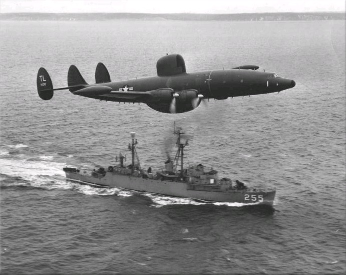
Pee-Wee says: There’s some confusion regarding L-8’s identity online, and a careful review of the chart above reveals why! Yes, Goodyear produced two blimps with the same name and civil registration in little more than a year. The original Ranger flew only briefly for Goodyear before joining the Navy as L-2 in February 1941. The second Ranger was built to replace the first but was instead delivered directly to the Navy as L-8 in February 1942 and likely never carried her civil registration or name. She was shipped to NAS Sunnyvale/Moffett Field in Santa Clara, California and first erected in February 1942, then assigned to locally based ZP-32. By August 1942 she had accumulated almost 1,100 hours, averaging approximately six hours airborne every day. Her crews considered her a reliable ship with good flying qualities.

L-8 was instrumental in the success of the Doolittle Raid on Japan. One of the many modifications to the B-25Bs used by the Doolittle Raiders involved swapping part of the bombardier/navigator’s plexiglass window glazing for glass. Unfortunately, the new parts arrived at NAS Alameda several hours after Hornet and the B-25s sailed for the Western Pacific on 01 April 1942. With the carrier’s deck unusable by other fixed-wing aircraft, there was only one type of aircraft that could safely deliver the 300-pound (136-kilogram) load. So, later that afternoon, the parts were airlifted onto Hornet’s forward deck by none other than L-8, flown by ZP-32 pilot Lieutenant Commander John “J.B.” Rieker, a highly experienced Goodyear LTA pilot who volunteered for Navy service.

That’s an odd collection of names for Goodyear’s blimps. What’s that all about?

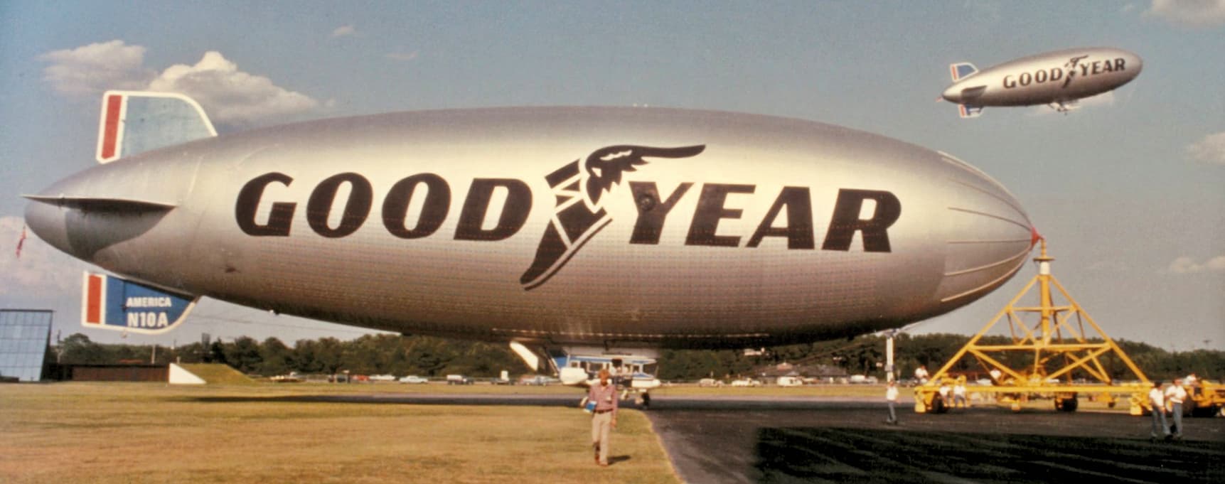
Pee-Wee says: In 1928, Goodyear Tire & Rubber Company’s President Paul Litchfield, the man who forged the company’s relationship with Luftschiffbau Zeppelin back in 1924, decided that the company’s blimps would henceforth carry the names of victorious America’s Cup sailing yachts. (Reliance, 1903; Resolute, 1920; Enterprise, 1930; Rainbow, 1934; Ranger, 1937) Not counting the Spirit of Akron in 1987, the tradition officially ended in 2005. Today, Goodyear solicits names from its employees and the general public.


:one: 
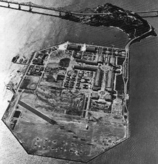
Dude, Where’s Our Airport?: Naval Training and Distribution Center Treasure Island

Pee-Wee says: ZP-32 operated four blimps during 1942: L-4, L-8, TC-13, and TC-14. The larger Army ships operated primarily from Moffett Field while the smaller L-Class trainers–modified with racks for carrying depth charges–flew from forward bases at Treasure Island, Watsonville, and Los Angeles. L-8 flew mostly from Treasure Island, with newly-promoted Lieutenant Cody as the detachment’s Officer in Charge and lead pilot.

It was the confluence of two disparate ideas that brought Treasure Island into existence. In the early 1930s San Francisco’s leaders desired a large airport closer to the city than the existing airport at Mills Field 12 miles (19 kilometers) to the south. At about the same time, the city was planning a large international exposition to celebrate the completion of the Golden Gate and San Francisco-Oakland Bay Bridges. The projects were combined: the city would construct an island on the tidal shoals north of Yerba Buena Island that would be used first as an exposition site and then rebuilt as an airport. The Army Corps of Engineers began construction in January 1937 and the Golden Gate International Exposition opened two years later. During the exposition’s second year in 1940, plans were made to transform the island into the new San Francisco Airport.

Pee-Wee says: And then the Navy showed up with an offer the city couldn’t refuse. :smirk:

The Navy intended to develop a portion of Treasure Island as a departure and receiving center for sailors and marines heading out into the Pacific, but when the shooting started in 1941, the Navy instead created a massive training and personnel/materiel distribution center on the island. An ongoing land dispute with San Francisco was finally settled in 1942 when the Navy seized the entire island. The exposition buildings were transformed into barracks, theaters, training centers, and prisoner of war detention centers, and new instructional centers and support buildings were constructed. A small shipyard–a Frontier Base–was built on the southeast shore near the hangars and docks from where Pan American Airways operated Martin and Boeing Clippers and Consolidated Coranados.

Pee-Wee says: There is a persistent rumor that the Navy swapped Treasure Island for land adjacent to the current San Francisco Airport (SFO). In reality the Navy directly compensated the city for the island by making $10 million (approximately $202 million today) worth of improvements to SFO, including a large landfill project that allowed for much needed runway extensions.

Training and Distribution Center (TADCEN) Treasure Island became a Naval Station (NAVSTA) in 1947 and remained in operation another fifty years. Today, the island is undergoing commercial redevelopment, and former Navy structures are steadily giving way to modern houses, condominiums, and community services. There are currently no homes for sale here, but you can find new condos on neighboring Yerba Buena Island, including a 3 bedroom, 3.5 bath, 2,330 square foot (216 square meter) unit for $3.395 million, or a 1 bedroom, 1 bathroom, 612 square foot (56 square meter) unit for $595,000.

Pee-Wee says: $3.395 million you say? Put me down for two. :smirk:


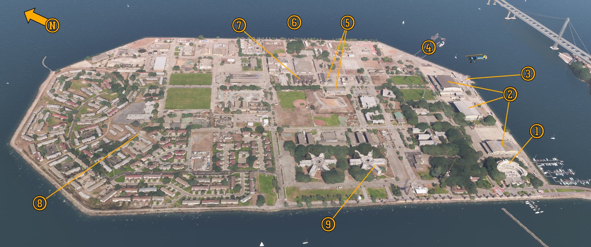
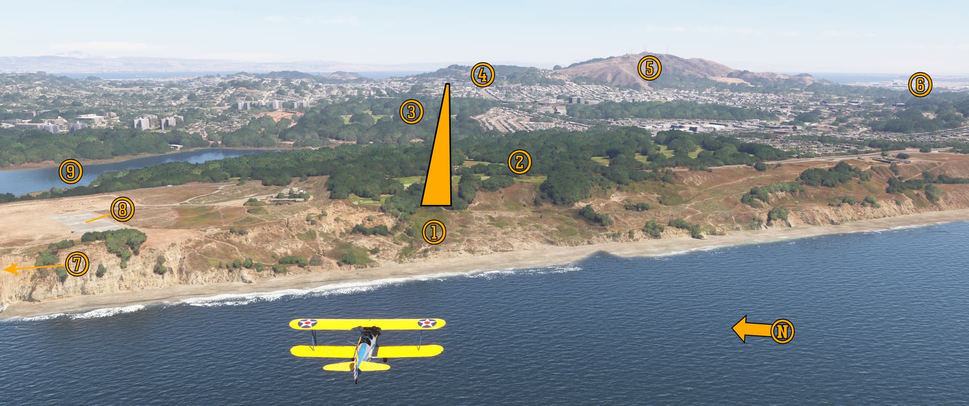
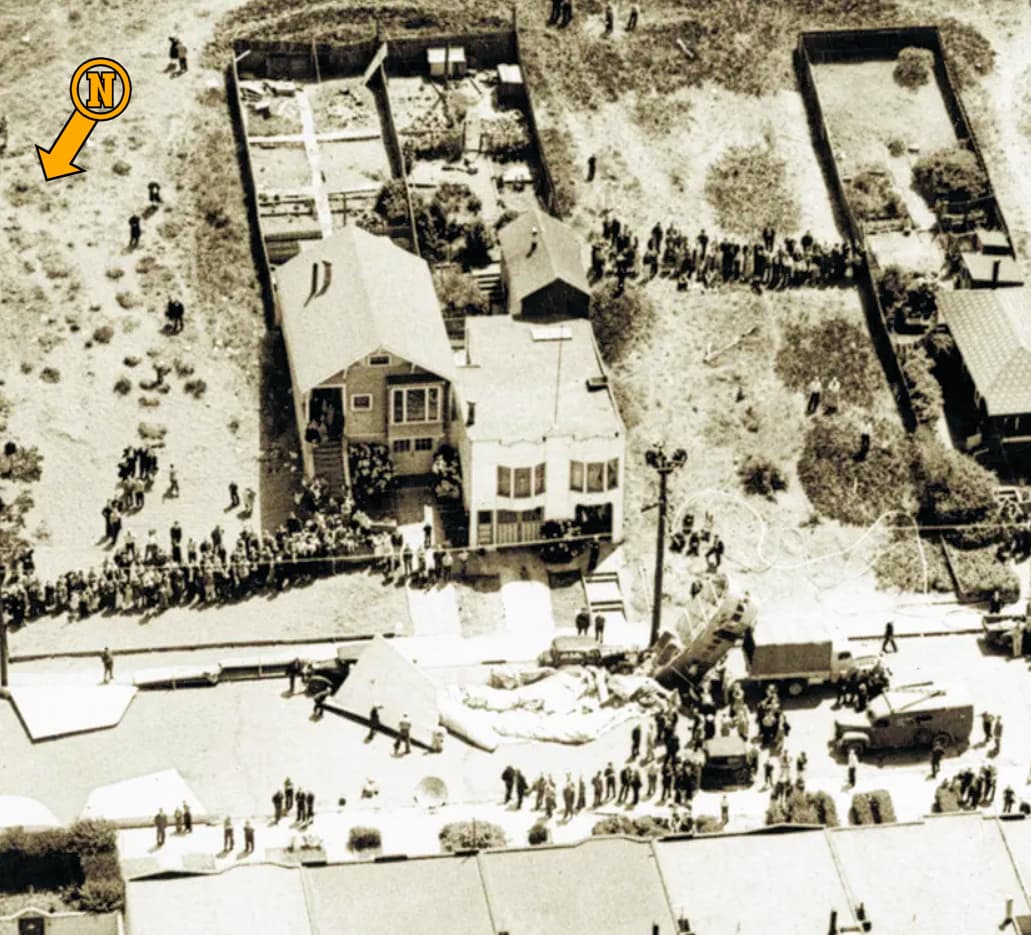
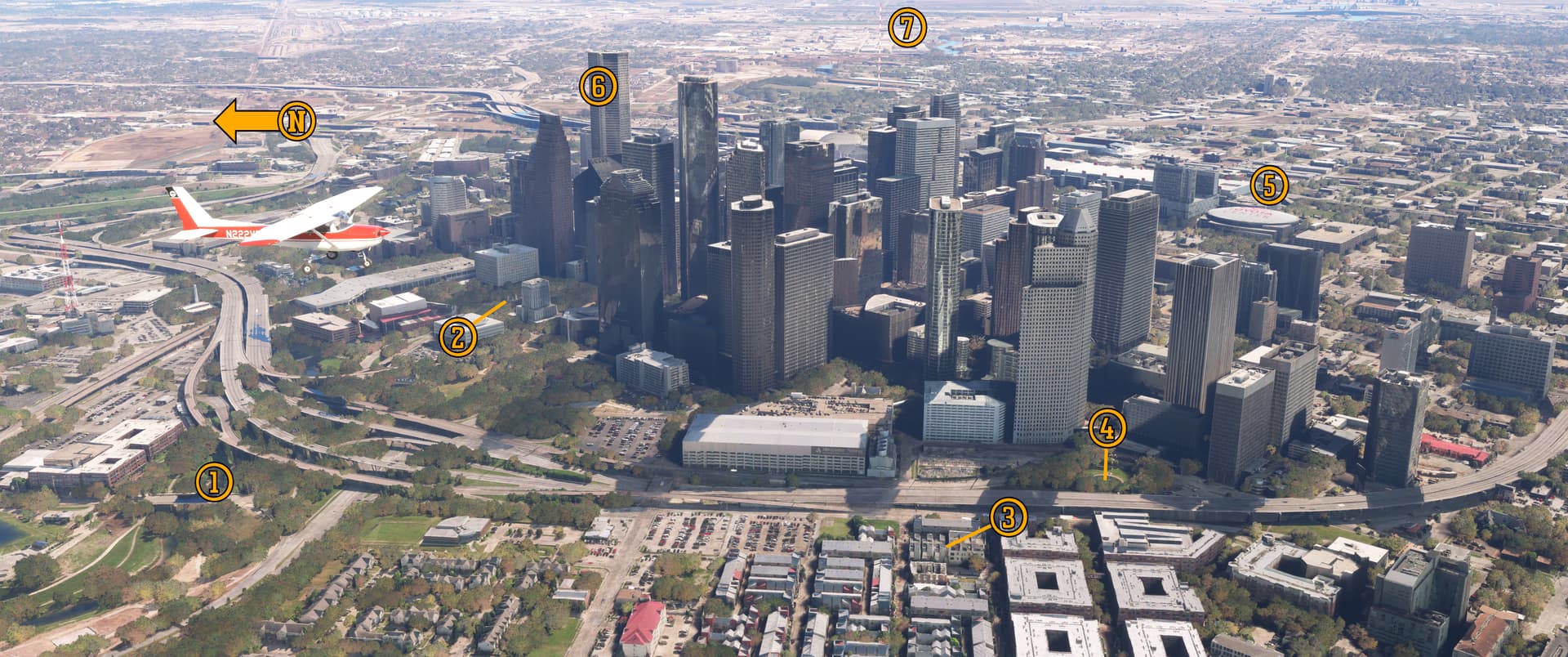
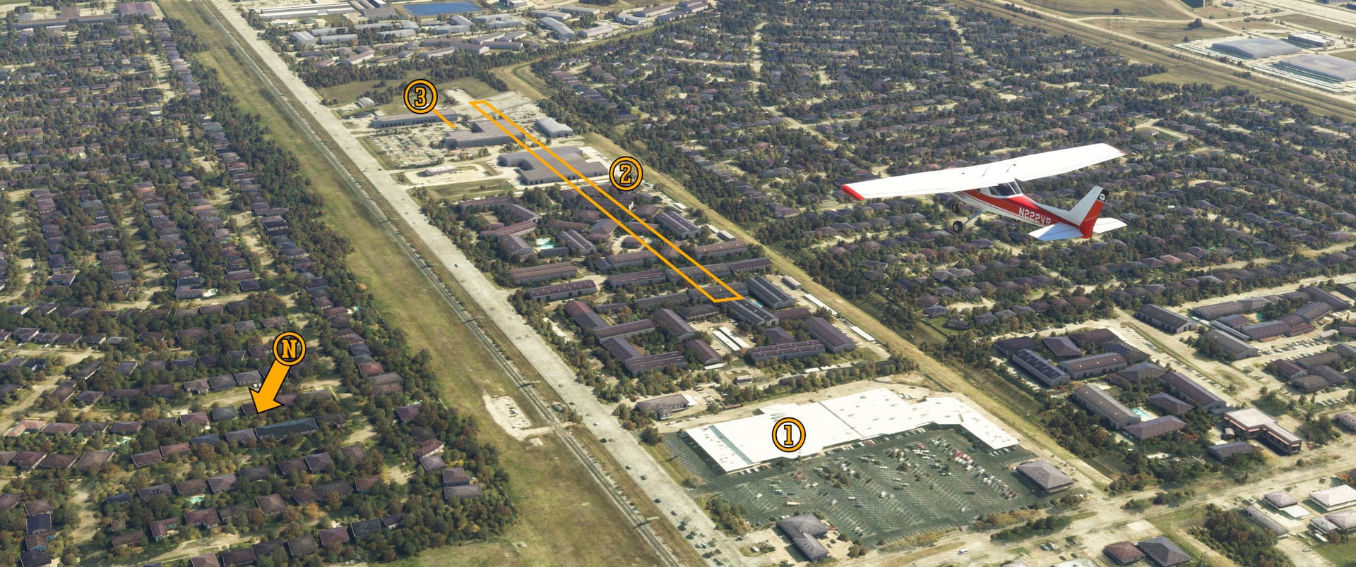
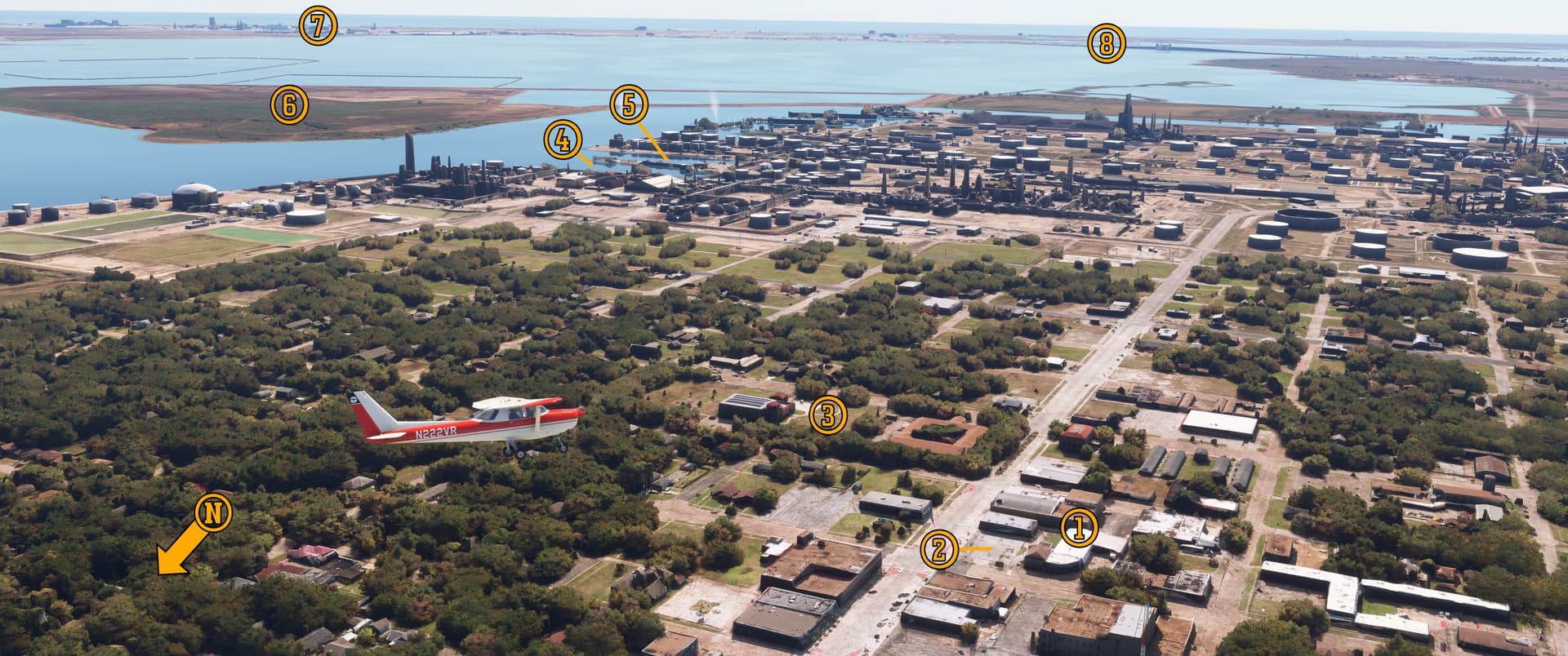
Pee-Wee says: Here we are flying roughly northwest over Treasure Island. That’s the eastern span of the San Francisco-Oakland Bay Bridge in the upper right. Some exposition buildings were intended for future airport use, including the (1) Administration and Terminal Building and (2) aircraft hangars. The new airport’s longest runways would have created a giant “X” across the island but would have been limited to about 5,000 feet (1,520 meters) in length, and Yerba Buena Island and the SFO-OAK Bay Bridge would have obstructed the southern approaches. The “major airport” on Treasure Island was never going to work without serious improvements and landfill. :face_exhaling:

Any original MythBusters fans here? This (3) is the Treasure Island Sailing Center, where Adam Savage and Jamie Hyneman not only repaired a boat using duct tape, but also constructed a functioning sailboat from the miracle material. Several other early episodes were filmed on TI during the hit television show’s thirteen-year run.

Pee-Wee says: (4) Here’s where the Frontier Base was located. The facility could repair offshore and inshore vessels as large as 2,200-ton destroyers and was staffed roughly equally by military and civilian tradesmen. Many small ships were decommissioned here after the war, and the Frontier Base itself closed shortly thereafter. Today a single pier remains–not one of the originals–although it’s a little “visibility challenged” in MSFS. I really like the name “Frontier Base.” It sounds like something from Firefly or other sci-fi story!

The (5) post office still stands at the corner of 5th Street and Avenue H, and today it’s home to a local moving company and a small auto detailing shop. The laundry and tailoring building still stands to the east across Avenue H in MSFS, but the real building was recently razed.

During the Golden Gate International Exhibition, famed aviator Paul Mantz flew sightseeing tours of San Francisco, Alcatraz, and both of the new bridges from the (6) east seawall dock using a Sikorsky S-38 amphibian. The flights were advertised as “a TRIP ENQUALLED anywhere…the thrill of boating as well as flying.” Almost directly across the street, the U.S. Army displayed its first YB-17 bomber outside the Federal Building and Colonnade of States. The huge bomber landed in the parking lot on the north portion of TI and was towed into position.

Pee-Wee says: (7) The Women Accepted for Volunteer Emergency Service (WAVES) barracks still stand just up the road from the post office, although it appears their days are numbered. Eighteen WAVES arrived at TI in 1942 and before the war’s end, nearly 800 worked here as physical therapists, nurses, medical orderlies, damage control and firefighting instructors, radio and radar operators, and a myriad of other ratings.

During the exposition, Goodyear’s TZ-Class blimp Volunteer flew from TI for five months, and during the first months of World War 2, ZP-32’s blimps flew from the exposition parking lot using an expeditionary mast and mobile maintenance equipment. One aerial photo shows a blimp (very likely either L-4 or L-8) moored (8) here. We can surmise that on 16 August 1942, this is the exact spot from where L-8 launched on her fateful patrol.

Remember those exposition buildings that were converted into barracks? They stood approximately (9) north and south of this spot. The buildings were never intended for long-term use and were constructed accordingly. In 1947 a fire started in one and quickly spread to the others. The resulting conflagration could be seen from around the bay and threatened to spread across the whole island. Firefighters from nearby communities converged on the island and soon gained control of the conflagration. Thankfully, although forty-one firefighters were injured, there were no fatalities.

Pee-Wee says: That was close! If that fire had happened during the war, the casualties (and the effect on America’s war effort) could have been catastrophic.


L-8 lifted off from Treasure Island about twenty minutes before sunrise on 16 August 1942 with Lt. Cody and Ens. Adams aboard. Aviation Machinists Mate 3rd Class (AM3) James Hill was scheduled to act as the flight engineer, but was removed shortly before takeoff when it was determined the ship was too heavy.

Pee-Wee says: And here’s where the conspiracy theories begin. At the inquest following the incident, ZP-32’s commanding officer and the Ensign commanding the Treasure Island ground party attested that L-8 was 200 pounds (90 kilograms) statically heavy at launch. “What was onboard that made the blimp too heavy, and why would the crew risk flying like that” you ask? Let me explain what “heavy” means in this case. Brace yourselves: I’m going full blimp. :scream:

Never go full blimp.

(TLDR: L-8 wasn’t “too heavy” to fly. Seriously, if you find math and physics boring, jump ahead to :two:. No judgement here!) :kissing_heart:

Blimps use two types of lift to fly: static and dynamic. Static lift is generated by the difference in density between the lifting gas within the blimp’s envelope and the surrounding atmosphere (i.e. buoyancy), just like a hot air balloon or helium-filled party balloon. At any given time, blimps are either statically heavy, neutral, or light. A statically heavy blimp weighs more than its static lift and will sink, while a statically light blimp weighs less than its static lift and will rise. On the morning of 16 August, L-8 was statically heavy, which is not an abnormal condition. In actual fact, according to the squadron commander’s testimony, ZP-32’s L-Class blimps could operate up to 600 pounds (272 kilograms) statically heavy. The confusion likely comes from attempting to correlate a blimp’s static heaviness to an airplane being overweight.

How much static lift could an L-Class blimp produce?

Pee-Wee says: Stand back…she’s going to math! The L-Class blimp envelopes had a theoretical maximum volume of 123,000 cubic feet (3,483 cubic meters). Navy LTA manuals state that each 1,000 cubic feet (28.3 cubic meters) of Helium gas can lift 62 pounds (28.1 kilograms). Therefore: 123,000 cubic feet of Helium gas x 62 pounds per 1000 cubic feet = 7,626 pounds of static lift.

That doesn’t seem like much from such a large envelope, does it?

Pee-Wee says: It isn’t, and that’s gross lift, not useful lift. If you want to know how much “stuff” you can carry, you’d have to subtract the weight of the blimp itself, which we unfortunately don’t know. James Shock, author of U.S. Navy Airships, says the L-Class had a useful static lift of only about 2,000 pounds (907 kilograms).

So, how does a statically heavy blimp takeoff and why doesn’t it just sink back to the ground like an old party balloon?

Pee-Wee says: That’s exactly what would happen if it weren’t for the second type of lift. Dynamic lift is generated by aerodynamic forces on the blimp as it moves through the air, usually by increasing the blimp’s angle of attack. The effect is dramatic: a K-Class blimp travelling at 20 knots (37 kilometers per hour) with an angle of attack of 10 degrees generates approximately 1,400 pounds (635 kilograms) of dynamic lift against a useful static lift of about 8,000 pounds (3,629 kilograms). A statically heavy blimp must make up for its “heaviness” by making a running takeoff like an airplane or getting a boost from its ground crew. Again, this is a normal situation.

Some people say that L-8 was heavy because of secret equipment it was carrying, and that the crew wouldn’t have allowed the blimp to fly “too heavy.” You’re saying that’s bogus.

Pee-Wee says: Yup. Later in his testimony, the squadron commander states that morning flights usually carried two crewmembers, while afternoon flights subject to superheating carried three. Superheating occurs as the sun warms the helium, reducing its density and increasing the blimp’s buoyancy, generally by about 1% for every 5 degrees Fahrenheit (0.5 degrees Celsius). So, it was completely normal for one crewmember to be left behind on a morning flight.

What about the dew? Some reports indicate that AM3 Hill was left behind because of the extra weight of water on L-8’s envelope. Does water really weigh that much?

Pee-Wee says: Oy. Now we’re into elliptical math. You’re up, Einstein. I’m going to find some Tylenol. :wink:

Okay, here’s an exceptionally rough calculation. An L-Class blimp’s envelope had a surface area of approximately 7,000 square feet (651 square meters). Let’s assume approximately one third of that–2,400 square feet (223 square meters)–was covered by dew 0.02 inches (0.5 millimeters) thick. At 60 degrees Fahrenheit (15.5 degrees Celsius), that water weighs approximately 250 pounds (113 kilograms).

Pee-Wee says: An average Navy LTA crewman weighed 175 pounds (79 kilograms), so having Hill aboard would have made L-8 almost 400 pounds (182 kilograms) statically heavy. I don’t have access to any performance information for L-Class blimps, so we’ll demonstrate with a similar ship again. A K-Class blimp 200 pounds heavy and with zero headwind needed about 600 feet (183 meters) to become airborne using the rolling takeoff technique. At 400 pounds heavy that distance jumped to 1,100 feet (335 meters). Looking at period aerial photos, L-8 had barely 1,000 feet (305 meters) available for a running takeoff. So, there’s nothing mysterious about Lt. Cody’s desire to be 200 pounds statically heavy instead of 400 at takeoff. It would have been unnecessarily difficult to create that much dynamic lift in the distance available for takeoff. So…enjoy your day off, Mister Hill!

And none of this was abnormal.

Pee-Wee says: Not according to the testimony of multiple professionals involved. It’s just the nature of blimp operations before the development of modern airships with vectoring thrust and other innovations.

But why did they leave Hill behind and not Adams, who wasn’t even a qualified pilot?

Pee-Wee says: Let’s keep going and find out. :blush:


:two: Where’s Michael Bay When You Need Him?: The Golden Gate Bridge

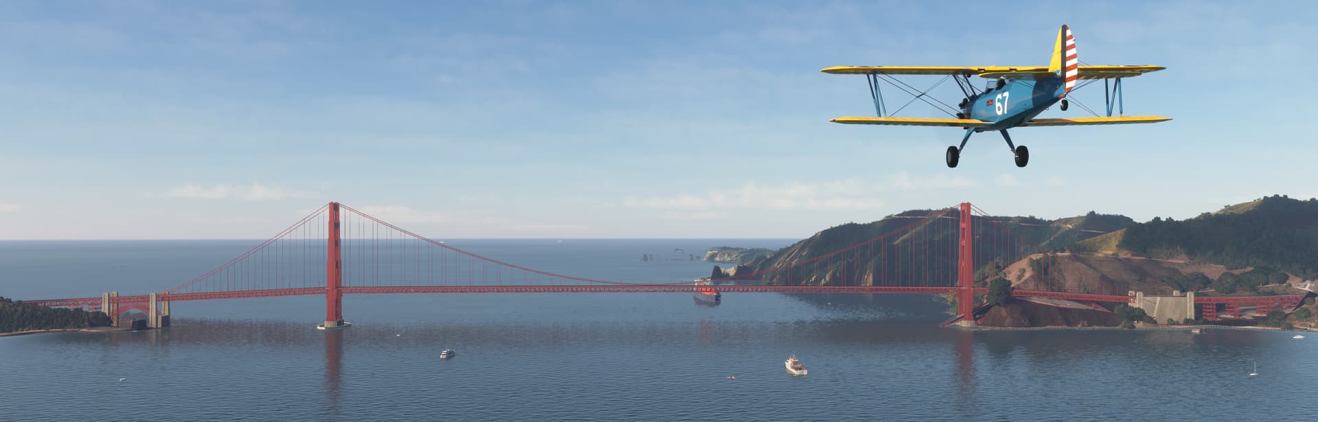
Ten minutes after takeoff, L-8 soared over the Golden Gate Bridge. It’s hard to imagine a time when this magnificent structure didn’t guard the entrance to San Francisco Bay, but in August 1942, it was only five years old.

Pee-Wee says: According to some completely unofficial, unverified, and highly tongue-in-cheek online records, the Statue of Liberty has been destroyed more times in films than any other landmark. The Golden Gate Bridge comes in second. Where’s “director” Michael Bay when you need him? :smirk:


Here we are flying west toward the Golden Gate. (To clarify for non-locals, the Golden Gate is the narrow strait connecting San Francisco Bay to the Pacific Ocean. The Golden Gate Bridge spans the Golden Gate.) Marin County is on the right, and San Francisco lies just beyond the left edge. It appears that Point Bonita in the distance is having some display issues! The Golden Gate is approximately one mile (1.6 kilometers) across, and until 1967 the Golden Gate Bridge was the longest and tallest suspension bridge in the world.

Pee-Wee says: As Cody and Adams approached the Golden Gate, the rising sun probably caused the tops of the support towers and the clouds beyond to glow. What a sight that must have been!


Pee-Wee says: Why did AM3 Hill get off L-8 and not Ens. Adams? We don’t know for certain, but there are some clues.

Lieutenant Cody joined the Navy in 1932 and served two years as an enlisted sailor aboard the battleship Tennessee until receiving an appointment to the United States Naval Academy. He graduated in 1938 and returned to sea aboard the cruiser Milwaukee and destroyer Biddle before heading to NAS Lakehurst for LTA pilot training. Cody was designated a naval aviator in December 1941 and reported to ZP-32 at NAS Moffett Field. He was 27-years-old and lived with his wife, Helen, in Santa Clara. His logbook tallied approximately 760 total flying hours, with nearly 400 in L-Class blimps, most of those in L-8.

Ensign Adams joined the Navy in the early 1920s and served nearly his entire career with Navy LTA. He was a coxswain aboard Los Angeles until its decommissioning in 1932, served briefly as a boatswain’s mate aboard Akron before her fatal crash in 1933, and survived the Macon’s crash near Monterey Bay in 1935. Back at Lakehurst, he was commended for rescuing passengers and crew of Hindenburg when the German airship crashed there in 1938. Having previously advanced to warrant officer, he was commissioned an Ensign only the day before the incident. Thirty-eight-year-old Adams also lived in Santa Clara with his wife, also named Helen, and had logged almost 2,300 hours aloft, all in rigid airships.

While neither officer was considered inexperienced, Adams was the more senior and more experienced LTA man, but Cody was the more experienced blimp crewman.

Pee-Wee says: According to the squadron C/O’s testimony, Adams was expected to attend LTA pilot training and was completing a series of familiarization flights with ZP-32, including the flight aboard L-8 on 16 August 1942. We can draw the conclusion that, when it was determined that one crewman must remain behind, Cody had the choice between Hill, a freshly-enlisted mechanic, and Adams, a twenty-year veteran with experience in all manner of jobs aboard airships.

And considering L-8 was a reliable ship and the mission was likely expected to be a “milk run,” Cody decided to allow Adams to complete his familiarization flight and booted Hill overboard.

Pee-Wee says: That’s my guess, too. There’s no record outlining Cody’s decision so we’ll never know for certain.

That seems to be a recurring theme with this incident.

Pee-Wee says: Yes, but wait! There’s more! :wink:


:three: The Islands of Misfit Scenery: The Farallon Islands

Pee-Wee says: After clearing the Golden Gate, L-8 proceeded along its normal morning patrol route toward the Farallon Islands 31 nautical miles (56 kilometers) west of Treasure Island. Normally the blimp would have then flown north to Point Reyes, south to Montara Beach, and finally back north to the Golden Gate. But on 16 August, at 7:38 a.m., Cody and Adams reported they were four miles east of the Farallons and investigating an unusual oil slick. That message would be the last communication with L-8 and her crew.

As soon as Pee-Wee pulled me down this rabbit hole, something about the timeline seemed curious. L-8 departed Treasure Island at 6:03 a.m. and was four miles east of the Farallons at 7:38 a.m., one hour and thirty-five minutes after takeoff (Some reports say the radio call came at 7:50 a.m. We’re sticking with the squadron C/O’s original time from the inquest). The L-Class blimps cruised at 43 knots (80 kilometers per hour). At that speed, L-8 should have arrived over the oil slick approximately 38 minutes after takeoff, or 6:42 a.m. Even accounting for a 10-knot (5.2-meters per second) headwind, they should have arrived at 6:52 a.m. Clearly Cody and Adams were not flying at normal cruise speed or were following a meandering course. What were they doing?

We know they were maneuvering to observe sea traffic, and the two men were likely discussing Adams’s experiences aboard the Navy’s rigid airships. But remember that Adams was aboard to familiarize himself with blimp operations. Cody very likely allowed Adams to fly and “get a feel for” the airship since, having started his LTA career as a coxswain steering Los Angeles, Adams was not unfamiliar with piloting an airship. It’s hard to “get a feel for” an aircraft while flying in a straight line at a constant speed.

Pee-Wee says: At 7:38 a.m., one of the airmen radioed the L-8s’s position, and four minutes later stated that they were investigating an oil slick. According to sailors aboard nearby commercial and military ships, L-8 remained in the area until it dropped two smoke flares and climbed up into the overcast. The eyewitnesses were unable to say definitively whether the ship was under control.


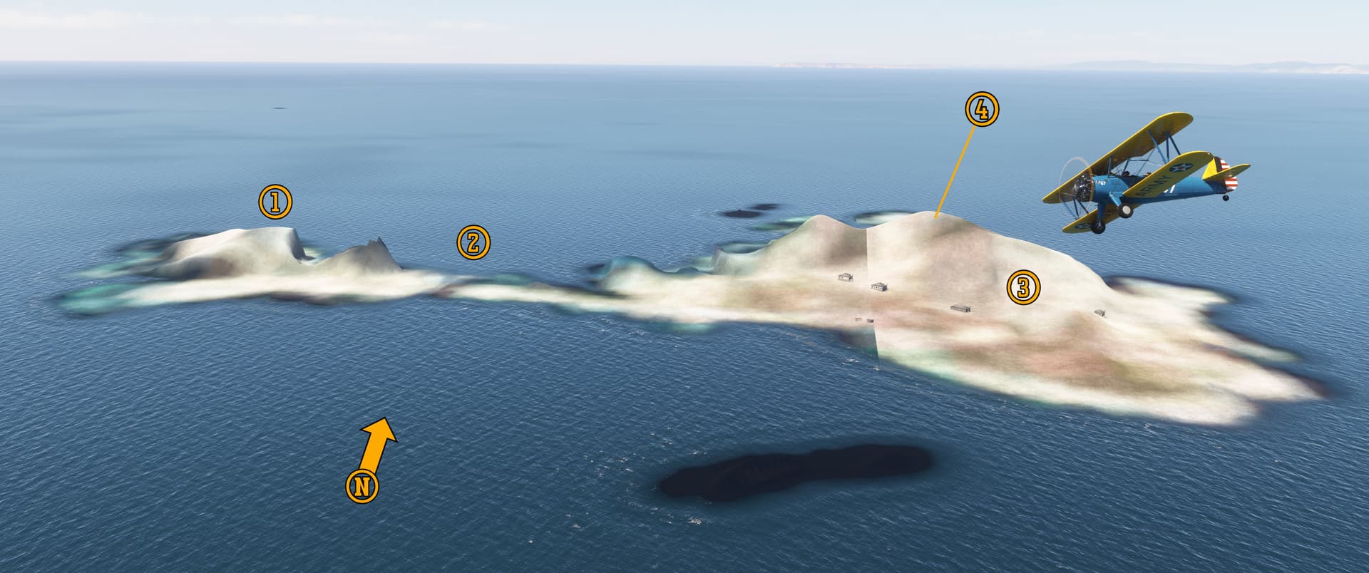
Pee-Wee says: So…here we are flying west over…uh…Southeast Farallon…maybe. It appears some sort of nuclear apocalypse happened here, or perhaps Asobo didn’t allow the dough to rise. Regardless, now that you’ve seen what the islands look, you don’t need to waste time flying out here unless you really want to. You’re welcome! :roll_eyes:

Is that…a black hole?

Pee-Wee says: That’s Seal Rock. Look closely and you’ll see that there’s terrain there, just no texture. (1) Main Top Island–where the Liberty ship Henry Bergh wrecked in 1944–lies to the left of the very narrow (2) Jordan Channel barely visible in the narrow isthmus running to (3) Southeast Farallon. The Farallon archipelago is about 12 miles (19 kilometers) long and consists of four island groups: Southeast Farallon, Middle Farallon, North Farallon, and Fanny Shoal/Noonday Rock. Some mariners still refer to the islands as the Devil’s Teeth for their propensity for chewing into the hulls of ships that wander too close. Only Southeast Farallon is inhabited, by Point Blue Conservation Science and U.S. Fish and Wildlife Service researchers.

The U.S. Lighthouse Service established the first order Farallon Island Light atop (4) 246-foot (75 meter) Tower Hill on Southeast Farallon in 1855 (its ruins should be visible just ahead of our Stearman, but…oh well). Fifty years later the U.S. Navy constructed a high-frequency direction finding station on the plain below. The station was initially used for navigational assistance but provided valuable signal intelligence (SIGINT) during World War 2 as part of the Navy’s Pacific Net. Other PacNet stations were located at Imperial Beach and Point St. George, California; Bainbridge Island, Wahington; and Sitka, Alaska.

We found two independent sources referencing a “secret radar station” on Southeast Farallon or Maintop Island during World War 2, including a photo purportedly looking down on the station from Tower Hill. Unfortunately, we weren’t able to find any reliable information about the rumored station, and there isn’t anything identifiable as a period radar in the photo. We’re not saying there wasn’t a radar station on the Farallons, we just can’t find any information about it, which seems a little suspect.

Pee-Wee says: Any environmentalists reading should probably skip this next paragraph. :grimacing: From 1946 until 1970 the United States dumped more than 47,000 steel drums containing laboratory radioactive waste at two sites southwest of the Farallons, the closest being only 8 miles (13 kilometers) away. Years later, experts determined that removing the rusting barrels would likely spread the contamination, and they were left in place. According to the Environmental Protection Agency, most of the material has decayed by now.

The Navy’s light carrier CVL-22 Independence rests about 14 miles (23 kilometers) south of Southeast Farallon. Having survived World War 2, Independence was used in the Crossroads Able and Baker nuclear tests in 1946. She sustained severe damage and received high doses of radiation and was later towed to San Francisco Bay for decontamination experiments before being scuttled by naval gunfire.


From the Farallons, L-8 would have turned north toward Point Reyes. What actually happened is unclear, and we have only a few data points from the official inquest. According to the squadron C/O:

  1. L-8 departed Treasure Island at 0603 local time.
  2. The blimp was four nautical miles (7.5 kilometers) east of the Farallons between 0738 and 0742 local time. We presume this means Southeast Farallon, the only island readily identifiable from a distance at low altitude. Eyewitnesses aboard ships nearby reported that the blimp remained in the area until approximately 0900, and possibly as late as 0945, although those times are unverified.
  3. The pilot of a Pan Am Clipper over the Golden Gate Bridge reported sighting the L-8 at 1049. It is unclear whether the reporter meant that he or the blimp was over the bridge.
  4. A Navy OS2U patrol plane reported that L-8 was three nautical miles (5.5 kilometers) west of Salada Beach (known today as Sharp Park Beach) at 1100, reportedly above a solid overcast cloud layer.
  5. An Army P-38 fighter reported that L-8 was near Mile Rock two nautical miles (four kilometers) outside the Golden Gate at 1105.
  6. A Navy enlisted man reported the misshapen L-8 was over land “south of San Francisco” at 1115. The squadron C/O received another report that L-8 landed at Fort Funston approximately six nautical miles (11 kilometers) south of the Golden Gate very shortly after the previous report.


:copyright: OpenStreetMaps
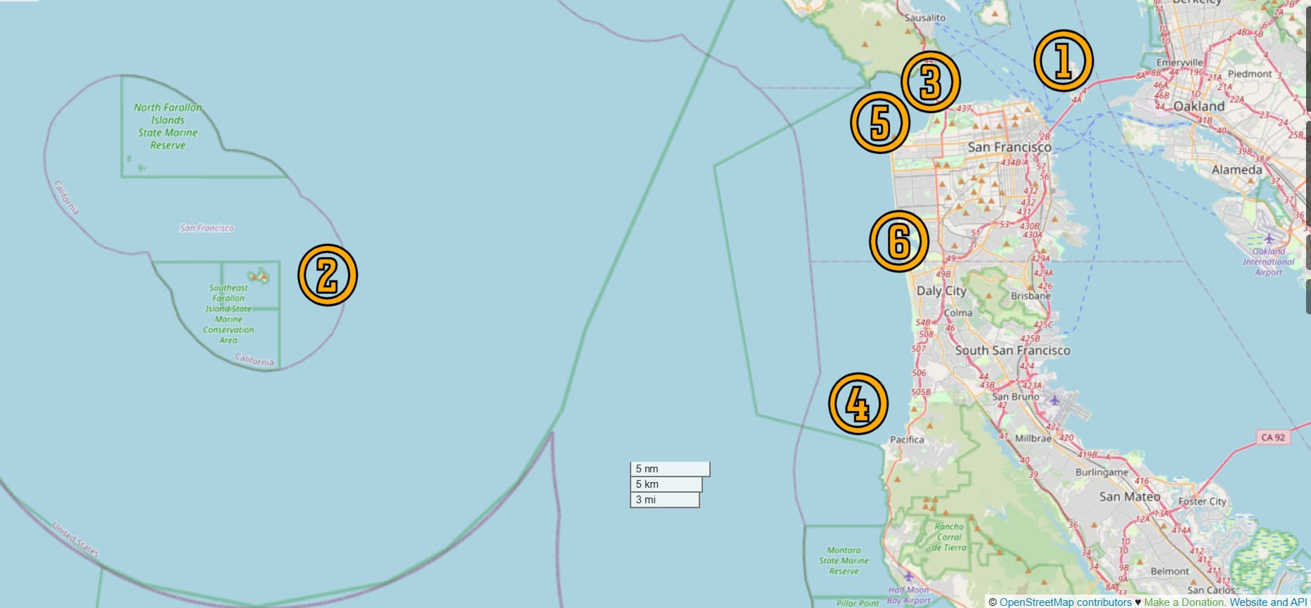
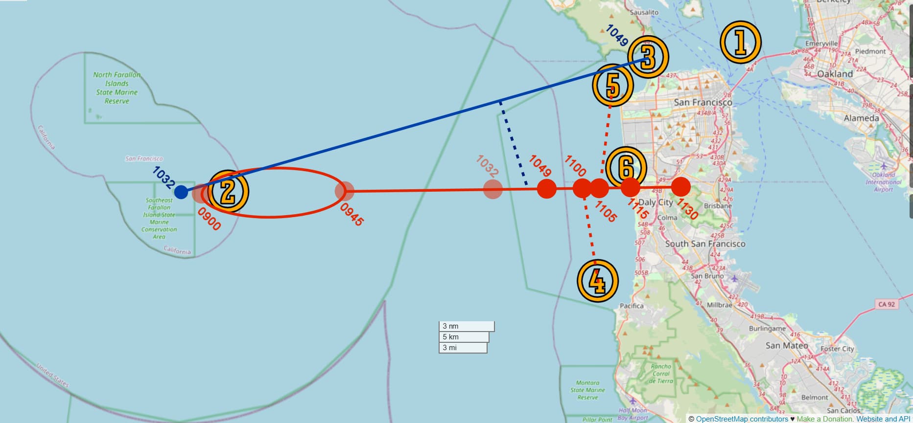
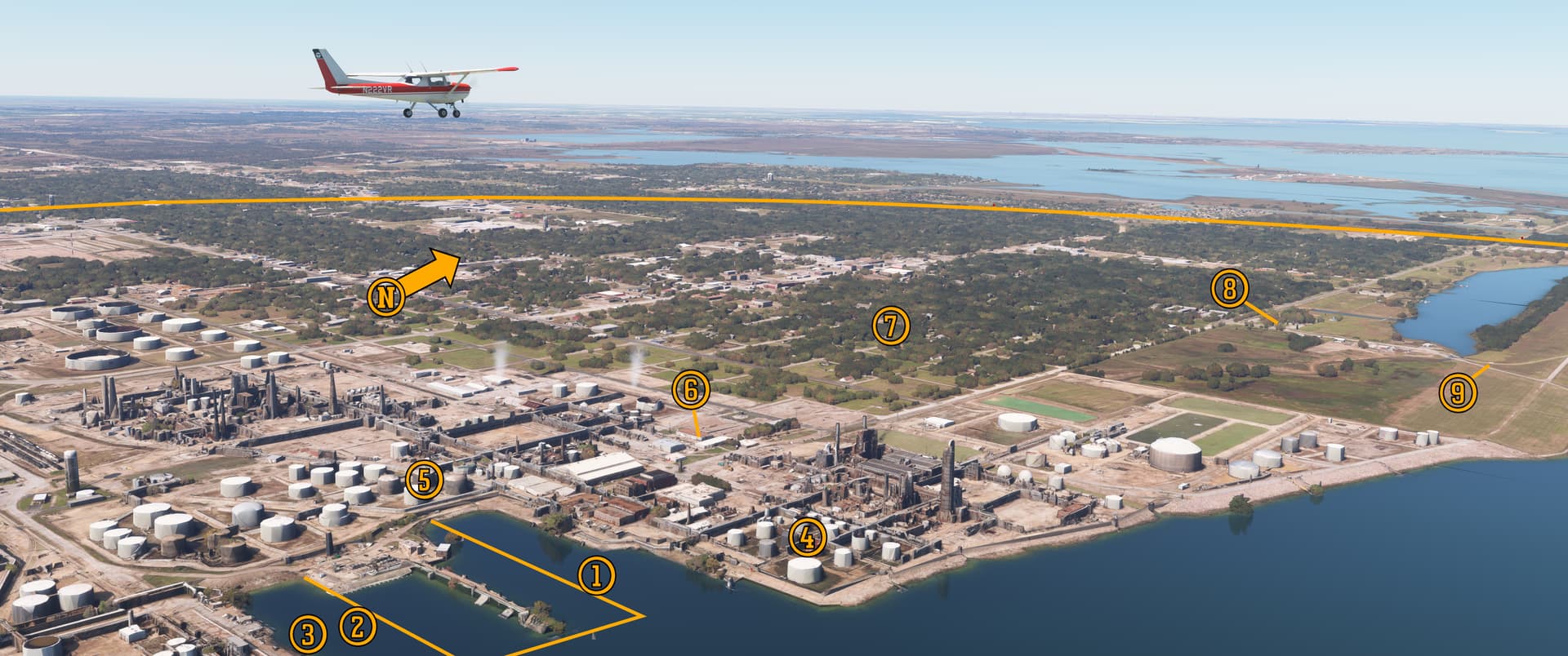
Pee-Wee says: So, here’s the big picture as initially reported, and it’s just a mess. (1) Here’s Treasure Island. We know it took about an hour and a half for L-8 to reach (2) the point four miles east of the Farallons, and she remained in this area until 0945 at the latest. She was next sighted by the Pan Am crew (3) “over the bridge” at 1049, (4) west of Salada Beach eleven minutes later, (5) over Mile Rock five minutes after that, and (6) near Fort Funston at 1115. She settled to the ground in Daly City at approximately 1130.

Let’s calculate the speeds necessary to reach those points at those times. If L-8 departed the Farallons at the latest time (0945), she needed a ground speed of 21 knots to reach the Golden Gate Bridge at 1049.

That sounds reasonable if she was under power or drifting with a strong westerly wind.

Pee-Wee says: Yes, it does. But to then reach the spot off Salada Beach at 1100 would require a ground speed of 67 knots.

Which is faster than L-8’s reported maximum design speed. And she’d be drifting into the wind, too.

Pee-Wee says: Now hold on to your hat. To reach Mile Rock at 1105 would require a ground speed of 125 knots.

That’s one fast blimp.

Pee-Wee says: This is why eyewitness reports–even those from highly trained people–are always suspect. There’s so much “slop” in these position reports that it’s hard to take them at face value. Why the obvious errors, and which reports are correct? The Navy OS2U and Army P-38 were above an overcast layer, which would make identifying specific landmarks difficult and explain their errors.

Sometime between 9:30 and 10:00 a.m. the Navy transmitted a radio message to all ships and aircraft in the area seeking information regarding the missing blimp. When that message was transmitted, the Pan Am Clipper inbound from Honolulu would have been nearly 100 nautical miles (185 kilometers) west of the Golden Gate and possibly outside reception range. The crew may have seen L-8 and thought nothing of it until they made contact with the Pan Am station at Treasure Island and finally received the message. They may have reported seeing the blimp when they crossed over the Golden Gate Bridge at 10:49 a.m., but with the report passing through a literal “game of telephone” before reaching the ZP-32 squadron C/O, it’s easy to see how it could have been morphed into “L-8 was over the bridge at 10:49.”

Pee-Wee says: What if we consider two known locations and times and plot a theoretical course from there? We know for certain L-8 made landfall near the Olympic Club golf course at about 1115 and landed in Daly City fifteen minutes later. From that, we can calculate an approximate ground speed: 10.3 knots. From that, we can deduce the following scenario:


:copyright: OpenStreetMaps
The solid red line indicates L-8’s approximate course, assuming a steady drift from its location near the Farallons to Daly City at 10.3 knots. For L-8 to reach Daly City at 1130, she would have started somewhere within the oval between the two faded dots labelled “0900” and “0945,” the time window within which she was last seen from nearby ships. The dashed red lines show the lines of sight from the (4) OS2U west of Salada Beach and the (5) P-38 over Mile Rock to L-8’s proposed position. The blue line indicates the approximate path of the Pan Am Clipper. The airplane’s flightpath may have taken her directly over Southeast Farallon at about 1032, and the L-8’s proposed position at that time is shown by the faded red circle labelled “1032.”. The blue dashed line indicates the line of sight from the Clipper to L-8’s proposed position between 1040 and 1045, when the airliner would have been closest to the drifting blimp.

Long story short: this scenario assumes Cody and Adams exited the L-8 from their last known position east of the Farallons sometime around 0900. If they left the ship earlier, a slower groundspeed would be required, but the path would be the same. We’ve made numerous assumptions based on questionable reports here, but this scenario is plausible based on the facts at hand.

Pee-Wee says: Let’s continue on to the beach where L-8 first landed.


:four: Putting From the Deep Rough: The Olympic Club Golf Course

At approximately 11:15 a.m., two men swimming off the beach below the Olympic Club Golf Course watched L-8 drift in low over the surf, her engines silent and her mooring lines dragging the water. They attempted to wrangle the wayward airship to no avail, and she continued inland, crashing up the cliff face. One of the ship’s Mark 17 depth charges was dislodged by the impact and landed harmlessly on one of the fairways. Freed of the extra weight, L-8 rose into the sky again and drifted east toward Daly City.


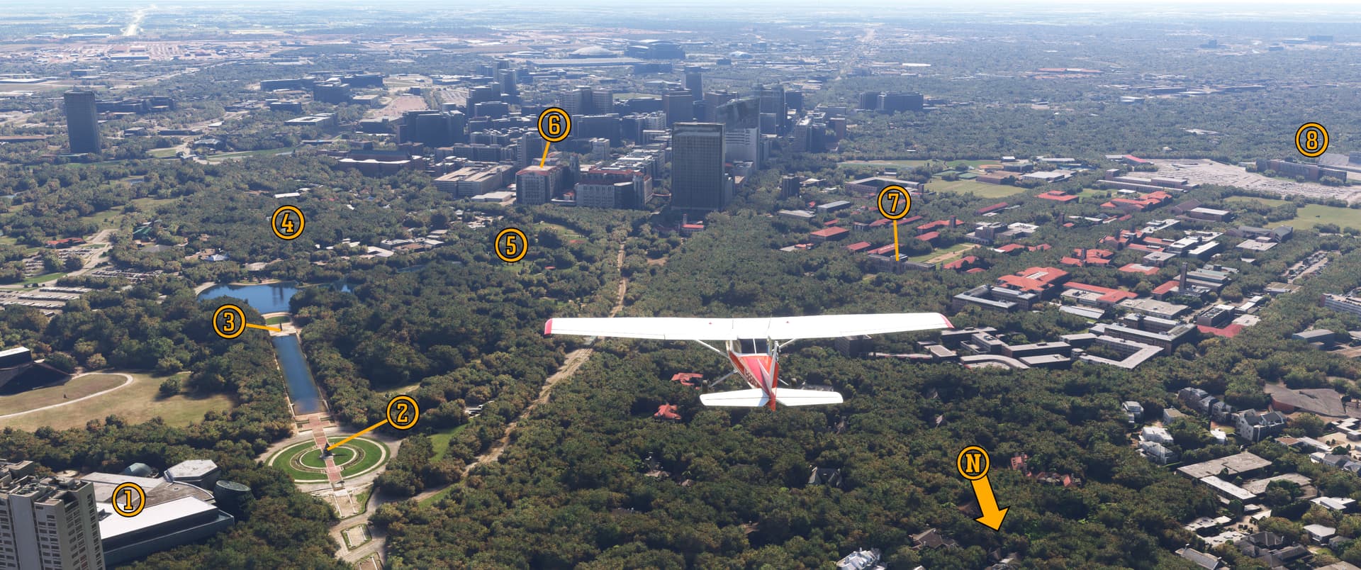
Pee-Wee says: Here we are flying east along the L-8’s probable route toward Daly City. The airship first landed somewhere on the (1) sandy cliffs below the (2) Olympic Club’s 18-hole Lakeside and Ocean Golf Courses. One eyewitness stated that L-8 followed a narrow valley up into the cliffs. The only “valley” we could find is just to the left of (1). L-8 rose higher into the sky and drifted over the neighboring (3) San Francisco Golf Club. In the distance are the (4) Crocker Hills where she eventually landed, (5) San Bruno Mountain, and (6) San Francisco International Airport. (7) Fort Funston lies off the left edge of the photo, north of Nike surface-to-air missile site (8) SF-59L, which lies on the western edge of (9) Lake Merced.

The Olympic Club was founded in 1860 and is the oldest athletic club in the United States. The neighboring and financially troubled Lakeside Golf Course was purchased in 1917 and became the Ocean Club’s Lakeside course. Routinely voted one of the finest golf clubs in America, the Ocean Club has hosted numerous championships, including five U.S. Opens and one Women’s U.S. Open. The San Francisco Golf Club behind is considered one of the most exclusive members-only golf courses, with some of its members ranked with the richest people in the world.

Pee-Wee says: Both clubs were “gentlemen only” until 1990 when, rather than face legal judgment in a pending lawsuit, the Olympic Club admitted women. The San Francisco Golf Club remains closed to the fairer sex. :neutral_face:

In August 1942 the San Francisco Airport was an Air Transport Command port of embarkation for troops and other personnel heading into the Pacific Theater of Operations. The collocated Coast Guard Air Station San Francisco opened in 1941 and remains the airport’s longest tenured resident.

Pee-Wee says: Fort Funston was a coastal defense battery built during World War 1 and named for Congressional Medal of Honor recipient General “Fighting Fred Funston.” In 1906 Funston was stationed at The Presidio and used his troops to protect San Francisco from looters, establish communications, sanitation, and medical stations, and return the city to order following the historic earthquake and fire. While he was lauded at the time, modern historians acknowledge that many of his efforts were ineffective or resulted in the further destruction of property and the murder of innocent civilians. Fort Funston eventually mounted numerous heavy artillery pieces, including 6-inch (155-mm) cannons intended for navy battleships cancelled after World War 1. The battery closed in 1963 and is today protected by the National Park Service.

Fort Funston entered the missile age in 1959 when Nike missile site SF-59L (“San Francisco Site 59–Launcher”) became operational. The site–one of twelve that defended the Bay Area–was inactivated four years later, and today it serves as the parking lot for the hang-gliding area here. The former launcher doors are clearly visible in the current Google Street View. The former barracks and operational buildings have been repurposed as the San Mateo and Ocean District Ranger Station.


Back to our wandering blimp, and…oh boy…

Pee-Wee says: Yup. Physics, incoming!

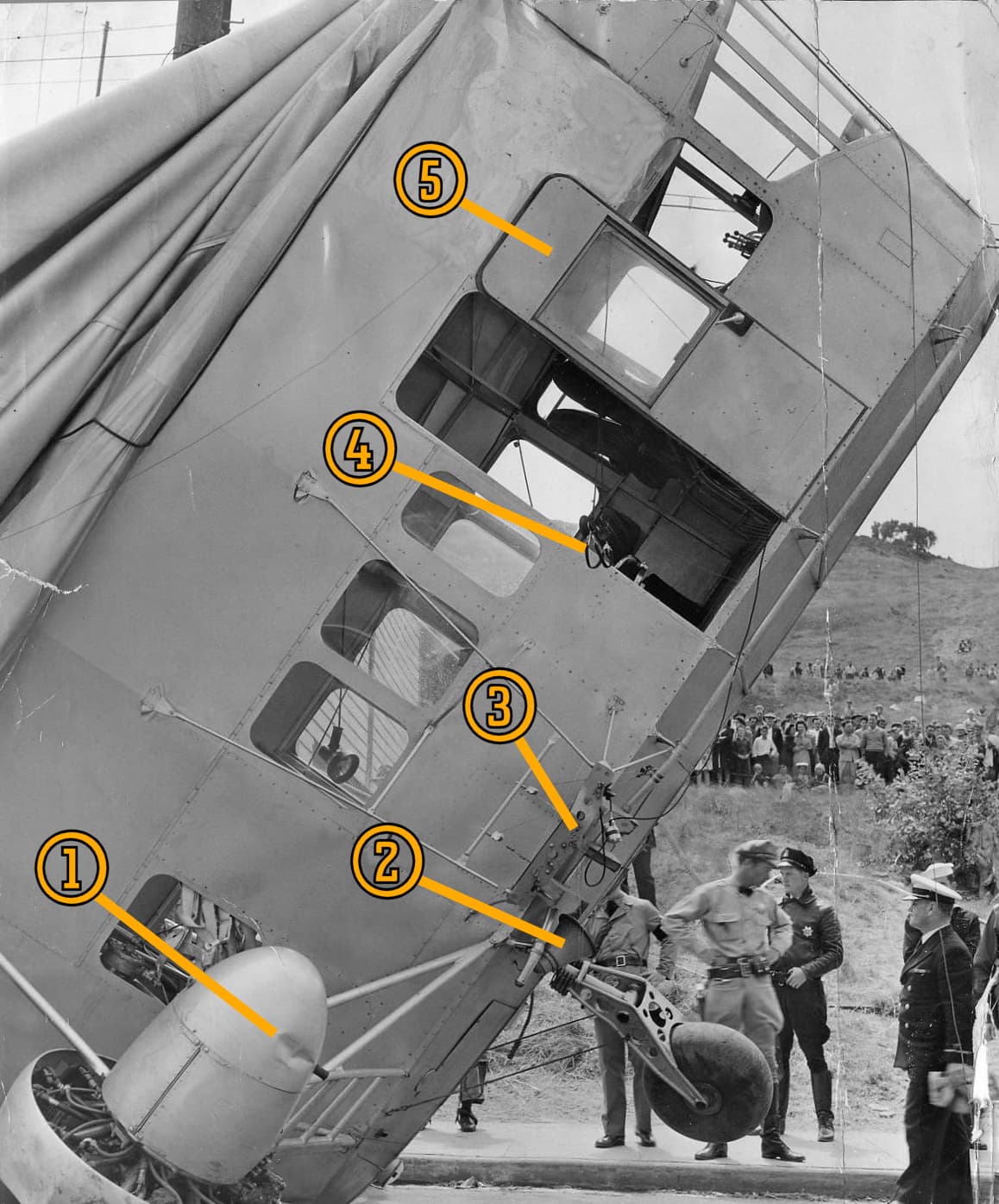
Here’s a famous picture from the National Archives showing L-8 drifting backwards over Daly City. Her pendant number was painted over and the red, white, and blue stripes removed from her rudders earlier in the summer of 1942, although she still carries the U.S. flag on her stern. The port-side Mark 17 depth charge is visible just below and in front of the port engine.


Pee-Wee says: How did she end up in this condition? Let’s go back to static lift. L-8 departed Treasure Island 200 pounds (91 kilograms) statically heavy. In his testimony the ZP-32 squadron C/O said he expected L-8 to become statically neutral at approximately 7:30 a.m. How does an airship go from heavy to neutral in flight? By burning fuel. AvGas weighs six pounds (2.7 kilograms) per gallon (3.8 liters), and at its normal cruising speed, L-8 burned 12 gallons (45.4 liters) per hour. So, between the blimp’s takeoff at 6:03 a.m. and 7:30 a.m., she would have burned about 18 gallons (68 liters) of fuel, or about 108 pounds (49 kilograms).

That’s still not equal to the 200 pounds (91 kilograms) static heaviness.

Pee-Wee says: The remainder comes from superheating of the helium by the rising sun and other atmospheric conditions, all of which increased the ship’s static lift. I have no way to prove his calculation, but the squadron C/O was an experienced LTA pilot, and I trust his answer. Therefore, when Cody and Adams made the radio call at 7:38 a.m., L-8 should have been statically neutral. :blush:

Witnesses reported watching L-8 maneuver over the water, drop smoke flares, and then climb up into the overcast. If, as the Navy believes, Cody and Adams fell overboard in a freak accident, would that make L-8 suddenly statically light?

Pee-Wee says: It sure would. Using the Navy’s standard weights, both men going overboard would remove about 350 pounds (159 kilograms) total from the blimp, which would likely cause L-8 to rise rapidly upward to her pressure height.

Pressure height?

Pee-Wee says: As a blimp–or any balloon for that matter–rises higher into the atmosphere, the ambient pressure decreases while the lifting gas’s pressure remains about the same, causing the envelope to stretch. Too great a pressure differential could cause the envelope to tear. The altitude to which a blimp can climb without risking damage is its pressure height. To climb above that altitude, the blimp must reduce the pressure inside the envelope. On 16 August, L-8’s pressure height was about 2,100 feet (640 meters), according to the C/O’s testimony.

The pressure can be reduced by manually venting helium, but that’s wasteful. Instead, blimp envelopes contain ballonets, smaller envelopes which are filled with ambient air to help trim the blimp and control pressure within the envelope. If the pressure in the envelope becomes too great, the air inside the ballonets can be vented, shrinking the ballonet and giving more volume for the helium, thereby decreasing the pressure. All airships also have safety valves that will automatically vent the lifting gas if the internal pressure becomes too great. Since neither Cody or Adams were aboard to control helium venting or the ballonets, L-8 simply climbed until the automatic vents opened, then descended again.

Normally, the ballonets could have been pressurized with ambient air to make up for the loss of pressure, but that would have required both crew intervention and the engines to be running. (See the two “tubes” sticking down from the envelope behind the engines? Those are the intakes through which the propeller wash pushed air into the ballonets.) With her helium severely depleted and her ballonets empty, L-8’s envelope didn’t have enough internal pressure to maintain its shape, and the weight of the control cab caused the ship to sag in the middle.

And having vented helium, L-8 settled back down below the overcast and ran up onto the cliffs near the golf course.

Pee-Wee says: Yes. Now, please remember that these explanations are simplified, and I’m no LTA pilot! Flying an airship is far more complicated than it sounds. :flushed:


:five: There Goes the Neighborhood: 400 Block East, Bellevue Avenue, Daly City

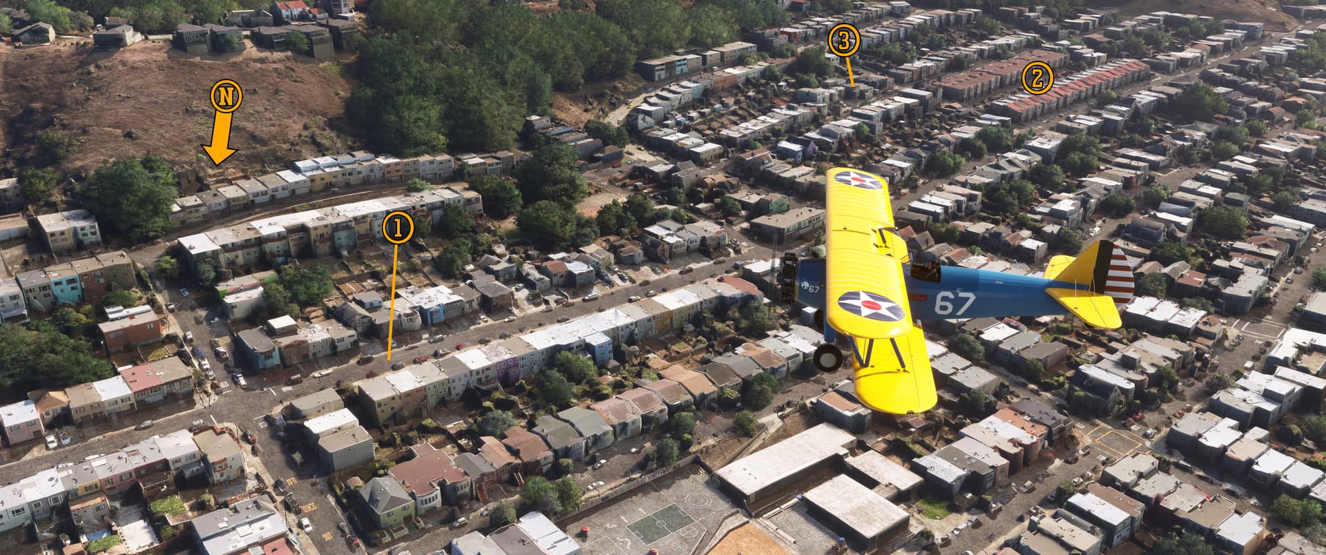
By 11:20 a.m. curious residents of Daly City watched as the partly deflated L-8 drifted lazily toward the Crocker Hills. Some witnesses reported seeing the two pilots inside the gondola while others stated the opposite. Regardless, fifteen minutes after crossing the shoreline, L-8’s journey ended abruptly three miles (five kilometers) inland on the 400 block of Bellevue Avenue.


Pee-Wee says: Here we are over the Crocker Neighborhood, flying east past the 400 block of Bellevue Avenue in Daly City. L-8 landed (1) right here, in front of 423 and 424 Bellevue. These (2) conspicuous, red-roofed homes two blocks west are a great landmark for finding the right spot.

Here’s your homework, friends! L-8 wasn’t the only aircraft that arrived unexpectedly in Daly City during World War 2. On 05 December 1943, Bell P-39Q 44-2437 crashed into the (3) vacant home at 73 Alexander Avenue during a formation training flight, killing pilot 2nd Lieutenant Wallace Hopkins. Another ship from the formation crashed into the Crocker Hills above the neighborhood, killing Flight Officer George Criswell. We don’t have room to cover these accidents in detail, but they’re definitely strange ones and worth some extra reading. The Aviation Safety Network and OpenSFHistory will get you started. Sorry, there’s no extra credit for this assignment! :blush:

Daly City encompasses land that once belonged to rancher John Daly. When San Francisco was devastated by the 1906 earthquake, many displaced residents encamped on Daly’s land. The businessman and his neighbors donated food and shelter to the victims and, when Daly later subdivided his land, many of them built new homes here. Fearing being overlooked by San Francisco and San Mateo County, they sought incorporation as a city in 1908. That effort failed, but another vote in 1911 passed, 132 for incorporation and 130 against. The new town was named in honor of Daly and boasted a population of 2,900.

Pee-Wee says: Hold up. 2,900 people, and only 262 voted?

Yes, but less than half that number were eligible to vote. Women weren’t even allowed to vote in 1911.

Pee-Wee says: That’s still only about eighteen percent of the voting population. I guess some things never change. :unamused:


Pee-Wee says: We’ve turned back to the southwest in this photo. You can clearly see (1) the spot on Bellevue Avenue where L-8 landed. Before settling onto the street, she rolled across the top of (2) Horace and Ethel Appleton’s home at 432 Bellevue and short-circuited electrical lines running along the south curb. The Daly City Fire Department arrived quickly and, finding the control cab empty, tore into the partially inflated envelope to look for the crew.


Not much has changed here since the unexpected guest dropped onto Bellevue Avenue, except for the greatly increased number of neighbors! Looking at aerial imagery and Street View, you’ll note that the houses at 419 and 423 Bellevue, and even the telephone pole the L-8 landed against, look much as they did in 1942.


Pee-Wee says: Here’s another photo from the National Archives, showing L-8’s gondola on Bellevue Avenue, looking south. You can see (1) damage to the Number 2 engine cowl from the blimp’s brush with the cliffs near the Olympic Club. (2) Here’s the 4-inch (10 centimeter) hailing loudspeaker, behind the (3) starboard depth charge rack, used for communicating with ships and personnel on the ground. The port-side depth charge has already been removed in this photo. Interestingly, one of the (4) pilot’s headphones can be seen dangling out the (5) cabin door, which is locked open. All cockpit switches were in their normal positions and all equipment was in place and functioning. The only thing missing was the crew.

Ah, the radio and the hailing speaker. Let’s talk theories again.

The “secret microwave or radar incapacitated the crew and made them fall out” theory rests primarily on one technical fact: L-8’s battery should have powered the blimp for 17 hours but was depleted when the Navy salvage crew arrived, about five and a half hours after takeoff. Those pushing this theory assume that the secret piece of equipment drained the battery. Let’s investigate.

The L-Class blimps were equipped with a single engine-driven 15-Volt DC generator that provided electrical power primarily for the ship’s radios, lights, and engine starters. It also charged the backup 12-Volt, 34-Amp lead-acid battery.

Pee-Wee says: The C/O stated that the L-Class’s meager battery was an ongoing source of concern, and that following a generator failure, it might only provide ten short radio transmissions before being exhausted. Repeated engine start attempts would further reduce that number.

Battery life can be estimated by dividing the available Amps by the load. For example, a 10-Amp battery can power a device that draws 5 Amps for 2 hours. Most experts recommend accounting for only 90 percent of the battery’s charge.

Some researchers point out that the ZP-32 squadron C/O stated that the electrical draw on L-8’s battery was 2 Amps, which is how the “secret equipment” theory arrives at the 17-hour battery life (34 Amp battery / 2 Amp draw = 17 hours). But there’s a problem with that number. Reading the testimony carefully reveals that the C/O was referring only to the Bogen hailing system drawing 2 Amps while in standby mode. The blimp’s radio was also on.

Pee-Wee says: We couldn’t find any data about the L-Class blimp radios, but we can draw some conclusions by examining period equipment. We estimate that L-8’s radio drew between 4 and 5 Amps when “on” but not transmitting.

That puts a total draw on the battery of between 6 and 7 Amps. Assuming 30.6 Amps available (90% of 34 Amps), L-8’s battery life with the radio and Bogen hailer running was approximately 4.3 to 5.1 hours. The blimp’s engines may have failed as early as 0800.

Pee-Wee says: It’s totally reasonable then, if we account for the battery’s usable charge and the actual electrical load, for the battery to be depleted when the salvage crew arrived at noon, without any “extra” equipment running.

Let’s consider one other thing that further discredits the “secret equipment” theory: airborne radars in use early in the war required 28-Volt electrical systems. There is no indication that L-8 was equipped with a “step up” transformer of any sort, and I doubt anyone was running a fancy new radar or microwave transmitter off 15 Volts. And that system probably wouldn’t work at all off the battery’s 12 Volts.

So, there you go: no “spooky” electrical equipment.


Pee-Wee says: So what happened to Lieutenant Cody and Ensign Adams? Expanding on the Navy’s conclusion, we can imagine this scenario:

At around 7:38 a.m. Cody and Adams encounter a suspicious oil slick east of the Farallons, and Cody maneuvers L-8 to investigate. After circling and evaluating the situation, Cody elects to drop smoke flares to mark the location. L-Class blimps weren’t equipped with drop chutes for flares: the crew had to “chuck” them overboard by hand. Ensign Adams collects the flares, opens the cabin door, and latches it open.

Navy crews were proud of their equipment, and L-8’s wooden floor is spotless under its polish, and maybe a little slick from sea spray blowing through the open door. Ensign Adams, like all officers, is wearing a low uniform shoe–a “loafer.” Somehow while dropping the last flare overboard, he slips, tumbles out the door, and becomes entangled in the exterior grip bar or starboard depth charge rigging. He frantically calls for help.

Cody closes both throttles and puts L-8 into a slight climb to keep her from striking the water while he’s away from his station, then moves to the open door to assist Adams. He struggles to pull Adams back inside, and then one or both lose their grips, and both men fall into the water below. They’re wearing life vests, but the impact knocks both men unconscious.

L-8 slows to a stop, but suddenly 350 pounds lighter and already neutrally buoyant, she lunges upwards into the clouds. As her altitude increases, her idling engines eventually sputter and stop, whether from carburetor icing or fouled spark plugs from running too rich at idle. As the errant blimp rises above the clouds, the helium in L-8’s envelope begins heating in the rising sun, pulling the airship higher into the sky. She eventually reaches her pressure height and begins venting helium through her automatic relief valves, then slowly descends back into the clouds until nearly striking the water.

With her helium depleted and her ballonets empty, her envelope can no longer maintain its shape, and the heavy gondola causes her to sag. She slowly drifts eastward and, several hours later, runs onto the sea cliffs, knocking the starboard depth charge from its rack.

Once again freed of weight, L-8 rises back into the sky, but achieves static neutrality quickly.
She drifts inland, dragging over houses and power lines until eventually landing outside the Appleton residence.

The average water temperature around the Farallon Islands in August is approximately 58 degrees Fahrenheit (14 Celsius), and neither crewman is wearing water survival gear. If either survived the fall, they lose muscle dexterity in about 15 minutes and consciousness in two hours. Thanks to confused reports from eyewitnesses, a search isn’t ordered until approximately 12:30 p.m., almost four hours after the men entered the water.

The waters in the vicinity of the Farallons are also rife with adult Great White Sharks, especially in August.


Well. That’s certainly…depressing. Two naval aviators lost, two wives widowed, and a valuable patrol blimp almost lost because of loafers and a slick floor.

Pee-Wee says: It’s purely conjecture, but it’s certainly plausible, at least more so than the other theories. My story didn’t involve strange equipment, G-Men, and aliens, although I would have loved to see Cody and Adams step off the alien “mothership” at the end of Close Encounters of the Third Kind alongside the Flight 19 crewmen. Ready for the epilogue?

Hold on. Gotta’ get more cookies.


:six: Epilogue

Pee-Wee says: Lieutenant Ernest DeWitt Cody was never recovered and, one year after his disappearance, was declared “missing at sea, presumed dead.” A headstone bearing his name was placed at Arlington National Cemetery, Section MJ, Grave 35.

Helen Cody married Edgar Delamater in April 1945. She bore two children–a daughter and a son–and worked as a legal secretary. Helen passed away in 1991, aged 73.

Ensign Charles Ellis Adams was never recovered and, one year after his disappearance, he was declared “missing at sea, presumed dead.” A memorial stone bearing his name was placed in East Los Angeles at Calvary Cemetery, Section R.

Helen Adams never remarried and bore no children. She passed away in 1944, aged 34, and rests beside her husband’s memorial.

AM3 James Riley Hill reportedly regretted not going along on the patrol, feeling certain that he could have prevented whatever happened to Cody and Adams. Before the war’s end, he attended LTA pilot training and served at NAS Hitchcock, Weeksville, and Moffett, and later as a LTA pilot instructor. Hill retired in 1963 and is believed to have passed away in 2022.


:copyright: Goodyear
L-8 was returned to Moffett Field and was inspected, repaired, and erected again using a spare envelope. She returned to service in September 1942 and trained Navy LTA crews until the war’s end. Goodyear purchased her control car in January 1946 and stored it with other former Navy blimps at Wingfoot Lake. In 1969 she was rebuilt as the GZ-20 type advertising blimp N10A America and flew from Goodyear’s new base in Spring, Texas. Retired in 1982, her control car was donated to the National Naval Aviation Museum in Pensacola, Florida and cosmetically restored. She remains on display today.


Well, that was a long read, wasn’t it?

Pee-Wee says: Yeah, but I finally got it out of my system! We both hope all of you found this tour interesting and informative. If not, then tune in next time for a more conventional tour.

We started writing this one several weeks ago, but time flies, and now it’s the 22nd, so happy birthday!

Pee-Wee says: Thanks, Babe, and thank you for an awesome day: Culver’s for dinner and my very own copy of James Shock’s U.S. Army airships, 1908-1942. Happy happy joy joy! :heart:

You’re a woman of simple pleasures.

Pee-Wee says: And by “simple” you mean “inexpensive.” :blush: Anyway, thanks again for joining us on this tour/investigation, everyone.

Do you have additional information or ideas regarding the events of 16 August 1942 or see a flaw in our logic? Feel free to respond here: we’re always open to learning new things.

Pee-Wee says: Bye for now! :kissing_heart:

4 Likes

Great post as always guys! Blimps are a fascinating piece of aviation history that I have only brushed the surface on. What an intriguing mystery this was and one I enjoyed learning about. I found your theory to be entirely plausible and based on the accounts we have it seems the most logical. I always enjoy reading your well researched posts. Happy flying!

1 Like

Thanks for the feedback! :kissing_heart: We were beginning to wonder if anyone read that last one. It was a little long…well, really long…and I suppose if blimps aren’t your thing, it was probably a little boring! I’m surprised the L-8 mystery isn’t better known. How many times has an aircraft returned home without its crew?

We’re going to fly our next tour today and start the writeup tonight, and I think it’ll be a good one. Care to guess where? It involves an abandoned STOL-port, a dreadnought, Boris Yeltsin, the Moon, and a cataclysmic explosion. :thinking:

–PW

2 Likes

You’re welcome. I personally read every one no matter how long they are. Anything aviation related is interesting to me. I was surprised I’d never heard about it. What’s funny is I’m fairly certain I have seen the gondola that is on display in Pensacola but I was fairly young as it has been several years since I’ve been there and no doubt didn’t understand the significance of it.

Oh my, that’s quite the combination. The STOL port and moon makes me think maybe somewhere in Texas? or I suppose Florida? but the other pieces don’t seem to fit in there. I’m intrigued and I look forward to reading your next report.

Oooh…you’re close! You’ll have to wait a few days to find out, though. :blush:

– PW

1 Like

The suspense is killing me! Looking forward to finding out the answer.

I’m thinking this has to do with SAC, mistaking the moon for something else, and a clear lake. :thinking:

1 Like

Well, that’s certainly an interesting theory, but I’m afraid it’s nothing that exciting! Remember that we’re talking about a large area, and the things I mentioned could refer to multiple locations.

Pee-Wee says: Hi, everyone! Nag and I are ready to post our next tour! Let’s get the administrative stuff out of the way first. Here’s the table of proposed starting points. We started at Hooks Memorial. Note that Williams Airport is closed in real life but still active in MSFS.

Airport Ident. Distance to First Point Runway
David Wayne Hooks Mem. KDWH 7 NM (11 KM) 7,000 Asphalt / 2,500 Water
George Bush Intercontinental KIAH 8 NM (12 KM) 12,0000 Concrete
Williams 9X1 9 NM (15 KM) 3,500 Asphalt
May T51 14 NM (22 KM) 3,400 Turf

Pee-Wee says: And here’s the target waypoints…

Waypoint Coordinates Lat/Long (Skyvector)
Goodyear Blimp Airfield (Closed) 30.0587 -95.4353 300331N0952607W
Battleship BB-35 Texas 29.7563 -95.0899 294523N0950524W
San Jacinto Monument 29.7450 -95.0807 294500N0950451W
Brown Shipbuilding 29.7507 -95.1720 294502N0951019W
Bethel Baptist Church 29.7556 -95.3762 294520N0952234W
Hermann Park 29.7186 -95.3909 294307N0952327W
NRG Astrodome 29.6849 -95.4078 294106N0952428W
Lone Star Flight Museum 29.6044 -95.1745 293616N0951028W
Randalls Grocery 29.5601 -95.1405 293337N0950826W
Clear Lake Metro Port 29.5562 -95.1373 293322N0950814W
Johnson Space Center 29.5580 -95.0886 293329N0950519W
Space Center Houston 29.5519 -95.0983 293307N0950554W
Texas City Airport (Closed) 29.4061 -94.9238 292422N0945526W
Port of Texas City, Pier O 29.3775 -94.8912 292239N0945328W
Seawolf Park 29.3342 -94.7788 292003N0944644W
Port of Galveston, Pier 20 29.3102 -94.7924 291837N0944733W

Pee-Wee says: And here’s the scenery packages you’ll need to see everything the way we did. Don’t worry: they’re all freely available at the tee-oh. Click on the blue scenery package name to head there. Thanks to PuffinFlight, iamblugames, droide, and snk93 for their contributions!

Pee-Wee says: This tour is a long one, so have your snacks and drinks ready. I’ll be right back! :blush:

Pee-Wee and Nag Over The 713

Houston, Texas City, & Galveston, Part 1


Welcome back, everyone! Today we’re heading to Houston, the fourth most populous metro area in America and the largest in Texas. Hey, Pee-Wee, what comes to mind when I say “Houston, Texas?”

Pee-Wee says: Violent crime.

Oh…okay…well, that’s not what I was thinking of.

Pee-Wee says: The smell?

Uh…no…

Pee-Wee says: Flash flooding? Toxic Superfund sites? Terrible public transit? A complete absence of zoning laws? Cheating at baseball?

Just stop.

Pee-Wee says: Ooh, I know! Humidity!

Spaceflight. I was thinking of spaceflight. The Johnson Space Center. NASA Mission Control.
“Houston, we have a problem.”

Pee-Wee says: Houston does have a problem.

Good grief. :man_facepalming: In all seriousness, Houston and Harris County have experienced explosive growth in previous decades and are still sorting themselves out. I’ve spent some time in the area, and unfortunately, Pee-Wee’s observations are mostly accurate. Houston will probably improve, but for the time being…it’s not our favorite place in the world.

Pee-Wee says: But there’s quite a bit of history in Houston! Today we’ll see everything from a dreadnought that served in two world wars to the scene of one of the nation’s worst industrial disasters, and even the grocery store where Soviet Communism died.

No matter how you measure it, Houston is a big place. It’s approximately the size of Bahrain, larger than Greater London, and more than twice the size of Berlin. Its population is equivalent to that of Laos and only slightly below that of Switzerland. Petrochemicals are Houston’s economic lifeblood, and it hosts the largest concentration of petrochemical industries in the world.

Pee-Wee says: The aerospace industry is another big player in Houston. Two major airports serve the city: Bush Intercontinental in the northeast suburbs (a United Airlines hub) and Hobby Airport to the south (a Southwest Airlines “focus city.”) The National Aeronautics and Space Administration’s Johnson Space Center is here, too.

Quite a few famous Americans hail from Houston, including former President George Bush and his son, former President George Bush, cosmetics great Mary Kay Ash, famed “hellfighter” Red Adair, and mega-star Beyoncé.

Pee-Wee says: Patrick Swayze was from Houston, too.

Roadhouse!

Pee-Wee says: And Dirty Dancing! Mmmm. :face_savoring_food:

You wanted to be Jennifer Grey, didn’t you?

Pee-Wee says: I wanted to be Patrick Swayze’s jeans.

Aaaanyway. Are you ready to go?

Pee-Wee says: I think so. We’ll start at Hooks Memorial Airport (KDWH) in our favorite JPL/WBSim Cessna 152 for this tour. She has good performance off the runway and in cruise, fuel efficiency, and an autopilot. What more could two digital tour guides want? :blush:


:one: The Blimps of Spring: Goodyear Blimp Airfield

Pee-Wee says: As if you didn’t already have an overdose of blimps from our last essay, this tour starts with a former blimp base! Opened in 1969 on 40 acres (16 hectares) west of Interstate 45 in Spring, Texas, Goodyear Tire & Rubber’s Houston blimp base initially housed a single, brand-new model GZ-20 blimp: N10A America, formerly the U.S. Navy’s L-8, the “Ghost Blimp.” The Houston base became Goodyear’s primary ■■■■■■■■ and maintenance facility, and the iconic Wingfoot Lake base was closed in 1972.

What the heck? I said ■■■■■■■■. :angry:

(Sorry, blimpologists. The forum software censors the accepted word for “the process of erecting an airship.” Use your imaginations.)

The new base boasted a 240 x 160-foot (73 x 49-meter) hangar, two 200-foot (61-meter) diameter mooring circles, and a public observation area. The 1990s heralded another realignment at Goodyear and the reopening of the Wingfoot Lake base. The Houston base closed in 1992.

Hey, did you know that this year (2025) is the 100th Anniversary of the launch of Pilgrim, the first Goodyear Blimp? :partying_face: :100: First flown on 3 June 1925, Pilgrim’s gondola is on display today at the National Air & Space Museum in Washington, D.C.


Here we are circling north of the former Goodyear blimp base. You can see (1) the asphalt pad where the hangar once stood and the approximate locations of the (2) two mooring circles. The observation area lay parallel to the highway on the (3) northeast corner of the airfield. (4) Here’s Interstate 45 slicing through the Texas-sized car dealerships on its way to Dallas. Across the highway is (5) Spring High School, which also opened in 1969. Further east is (6) Union Pacific’s Lloyd Yard, and in the distance is (7) George Bush Intercontinental Airport.

Unfortunately, thanks to new construction in November 2024, the last remnant of this blimp base–the hangar’s asphalt pad–is gone. Look quick before Bing updates its imagery!

Pee-Wee says: Today the blimp base is also covered by Home Depot and Lowe’s home improvement stores, with a Firestone tire and auto repair shop tucked between. I wonder if the Firestone employees know they’re sitting on land once owned by their archrival? :smirk:

The population of Spring has nearly tripled since the blimp base opened, and today more than 63,000 people live here. Olympic gymnastics phenomenon Simone Biles was born in Spring, and actor Jim Parsons was raised here.

Pee-Wee says: Next, we’re heading about 25 nautical miles (47 kilometers) to the southeast. Autopilot…activate!


:two: Fear Not, Texans: San Jacinto Battleground State Historic Site

Pee-Wee says: Our next stop isn’t just the site of the final battle of the Texas Revolution, but one of the most important battles in world history, not for its own sake, but for what followed.

On 21 April 1836 Sam Houston’s Army of the Republic of Texas routed General Santa Anna’s superior Mexican Army on this marshy ground alongside the San Jacinto River and Buffalo Bayou. Santa Anna was forced to sign the Treaty of Velasco which paved the way for Texas becoming an independent nation, but the Mexican Government refused to honor that treaty, even after the United States annexed Texas in 1845. The Mexican-American War erupted the following year and resulted in the annexation by the victorious United States of nearly half of Mexico’s territory, including the current states of Arizona, California, Nevada, and Utah, and portions of Colorado, New Mexico, and Wyoming.

Pee-Wee says: The Battle of San Jacinto indirectly determined that the United States would be the dominant power in North America, and even the world. Ironically, the battle also nearly brought an end to the United States, as the annexation of the new territories reignited the internal political battle over slavery…and we all know where that argument lead! :grimacing:

In early Spring 1861, after chasing the rebel Texans eastward, Santa Anna cornered the Texan Army here but failed to seize the initiative. The Texans attacked the bivouacked Mexican Army, catching many of the soldiers asleep, and after only eighteen minutes of battle, the surviving Mexicans retreated south in defeat. The Mexican Government made overtures about reclaiming Texas, but its military never returned.

Completed in 1939, the 567-foot (172-meter) tall San Jacinto Monument honors the brave Texans who fought and died here. It’s the world’s tallest masonry tower and approximately 13 feet (4 meters) taller than the Washington Monument, the world’s tallest stone tower. In 1990 its base was rebuilt to house the San Jacinto Museum of History. The monument is open to the public Wednesdays through Sundays, from 9 a.m. to 6 p.m.


Pee-Wee says: Here we are circling northwest of the historic site at the confluence of the Buffalo Bayou and the (1) San Jacinto River. (2) BB-35 Texas is moored where Texas Army commanders Burleson’s and Sherman’s troops encamped on the eve of battle. This (3) obelisk marks the exact spot where General Santa Anna surrendered to the conquering Texans. Over here is the (4) de Zavala Cemetery. Mexican General Manuel Fernández Castrillón–Santa Anna’s aide-de-camp and a soldier respected by Mexicans and Texans alike–is interred here. The (5) San Jacinto Monument stands on the field of battle, the reflecting pool running toward the Texas Army’s battle line. In the distance is (6) Baytown and the (7) Baytown Nature Center.

Pee-Wee says: Commissioned in 1914, the ten-gun, 29,500-ton dreadnought Texas is the second U.S. Navy ship to bear that name. During her thirty-four-year career, she supported American troops at Veracruz, escorted the vanquished German fleet to Scotland at the end of World War 1, escorted vital convoys across the Atlantic as war clouds closed over Europe in 1939, and supported Allied landings in the Atlantic and Pacific Theaters. She was the first battleship fitted with 14-inch (356-millimeter) main guns, the first equipped with a fire control system, the first U.S. Navy ship to mount fixed anti-aircraft guns, and the first battleship to launch an aircraft for gunnery spotting. Texas spent 478 days in combat during World War 2, and was damaged only once, by German artillery fire off the coast of Cherbourg in June 1944.

The Navy donated Texas to her namesake state in 1946. She was officially decommissioned here on 21 April 1948, exactly 112 years after the Battle of San Jacinto. The years (and the water) weren’t kind to the ship, and by 2020 she was in critical condition, taking on water and listing heavily. In August 2022, she was towed to Galveston for restoration, and when complete, she’ll remain there at her new permanent home alongside Pier 20.

Like all battleships, Texas swapped her main guns during several overhauls. Today, through the quirks of fate and the Navy’s maintenance program, she mounts nine of her original 10-inch guns from 1914.

Pee-Wee says: An excellent website about Texas can be found here. You’ll need at least a few hours to read everything there! And when you read one officer’s happy recollection of Jim, one of the ship’s mascots, have a box of tissues ready. :blush:


:three: Highways and Dams and…Sub-Chasers?: Brown Shipbuilding

During World War 2, the U.S. Government realized that the nation’s manufacturers possessed unrivalled expertise in managing large-scale construction projects, and that factories and tradesmen building washing machines, tractors, and highways could be redirected quickly to build airplanes, radios, and airfields. As a result, Allied soldiers and sailors rode into combat aboard Waco gliders built by refrigerator manufacturers, Sherman tanks built by locomotive works, and warships guided by compasses built by toy train makers.

One of the many companies that helped produce nearly 6,000 warships for the U.S. Navy was Brown & Root, a Houston-based construction company specializing in civil infrastructure projects like the city of Austin’s Mansfield Dam. Holding a contract for a quartet of PC-461 Class submarine chasers, Brown & Root established its Brown Shipbuilding subsidiary at its new Greens Bayou Fabrication Yard located at the confluence of the Greens and Buffalo bayous east of Houston. Twelve of the 173-foot (53-meter) anti-submarine boats plus thirty-two Landing Craft Infantry and 254 Landing Ship Mediums would eventually slide down the Greens Bayou ways.

The largest ships built here were thirty-eight Edsall Class and twenty-three similar John C. Butler Class destroyer escorts. The first ship–DE-238 Stewart–was launched in November 1942. We’ll actually see her later in the tour.

Pee-Wee says: Perhaps the most famous DE of all is DE-413 Samuel F. Roberts, launched here on 20 January 1944. Roberts was attached to “Taffy 3,” the small force of escort carriers, destroyers, and destroyer escorts that fought a superior Japanese fleet off Samar during the Battle of Leyte Gulf. Lieutenant Commander Copeland lead his crew in a desperate hour-long last stand against the Japanese battleships and cruisers, fatally torpedoing the cruiser Chōkai before the battered destroyer escort–its magazines nearly empty–succumbed to enemy fire. Ninety crewmen died, while the 120 survivors waited two days for rescue. The “destroyer escort that fought like a battleship” lived only 180 days and now rests 60 miles (97 kilometers) east of the Philippines, 22,621 feet (6,895 meters) below the surface, the deepest shipwreck ever identified.

After the war, B&R sold the Greens Bayou facility to cross-channel neighbor Todd Shipbuilding but returned in the late 1980s to build equipment for the offshore oil industry. Work stopped in 2004 and the facility was sold piecemeal to various industrial firms. Today it’s known as the Brown Shipbuilding Industrial Park.


Pee-Wee says: We’re flying west along Buffalo Bayou (part of the “Houston Ship Channel”) toward Houston proper in this southeast-facing screenshot. The submarine chasers and destroyer escorts were built on the (1) ways here and launched sideways into (2) Greens Bayou (the red line marks the original shoreline), then towed to the (3) finishing docks on (4) Buffalo Bayou. Todd Shipbuilding and the Kaiser Corporation built 208 Liberty ships and 14 T1 tankers at the (5) government shipyard on the former Irish Bend Island. The (6) 1,560-foot (480-meter) Sam Houston Tollway Ship Channel Bridge opened in 1982 but is slated for replacement in 2027. Crossing the bridge will cost you $1.50 (€1.38) in your car or between $4 and $6 (€3.67 and 5.50) in your RV.

The (7) San Jacinto Ordnance Depot was responsible for shipping, receiving, inspecting, and storing all ammunition passing through the ports of Houston and New Orleans during World War 2, and continued to store conventional and chemical weapons until 1959. Today the 4,954-acre (2005-hectare) site remains highly contaminated, but don’t worry: the Department of Defense estimates remediation will cost less than $7 million (€6.4 million) and should be complete by 2084. (Nope, not making that up :roll_eyes:).


Pee-Wee says: Many of you have probably seen this famous photo of ill-fated Lockheed WV-2 BuNo. 141310 “buzzing” the radar picket ship Sellstrom off Newfoundland. Sellstrom started life as Edsall Class DE-255 and was launched by Brown Shipbuilding on 12 May 1943, the last of the shipyard’s original eighteen destroyer escorts.

Let’s continue west toward downtown. Spoiler alert: everyone check for obstructions and the minimum safe altitude in this area. :unamused:


:four: H-Town Downtown: Houston’s Central Business District


We’re passing downtown Houston southbound in this east facing photo. Here’s (1) Eleanor Tinsley Park, part of the Buffalo Bayou Park. Yes, that’s the same Buffalo Bayou, flowing slowly eastward to the Gulf of Mexico from its headwaters near Katy, 28 miles (45 kilometers) to the west. Over here behind the red-roofed Hobby Center for the Performing Arts is (2) Tranquillity Park. It’s named not for the peace and relaxation you’ll find here, but for the Sea of Tranquility, landing site of Apollo 11 where men first set foot onto the Moon. Neil Armstrong’s famous quote is engraved in fifteen languages on bronze plaques near the park’s entrance. The undulating landscape and multi-level fountain is designed to resemble the Moon’s landscape, and is punctuated by tall columns that resemble Saturn V rocket first stage boosters.

Pee-Wee says: We’re not sure why, but the park’s name is intentionally misspelled, adding a second “L.” :thinking:

At the corner of Andrews and Crosby streets is (3) the Bethel Baptist Church Park. Built in 1923 and abandoned during the late '90s, this Gothic Revival-styled building burned in 2005, leaving only its outermost walls and edifice standing. The City of Houston purchased and stabilized the building four years later and repurposed it into a public park complete with seating and fountains within the confines of the original structure.

Pee-Wee says: Here’s a curious place. This is (4) Harmonica Man Park, jammed into the armpit of Brazos and Pease streets and Interstate 45. We searched the Internet high and low but couldn’t find a reason for the park’s name. If anyone knows, please respond below or drop a PM. Thanks! :kissing_heart:

Armpit? Is that a technical term?

Pee-Wee says: No, but you can picture exactly what I’m talking about, can’t you? :blush:

Fair point. Anyway, this is (5) the 18,000-seat Toyota Center arena, home of the NBA’s Houston Rockets. Across town is (6) the 1,002-foot (305-meter) JPMorgan Chase Tower, the tallest building in Texas and the world’s tallest five-sided building, although not a regular pentagon. In the early 1980s, building heights in downtown were capped to protect Hobby Airport’s airspace, so it seems the JPMorgan Chase building will maintain its superlative for years to come.

Pee-Wee says: Alright, everyone, we’re going to talk about an airplane crash next. Skip ahead to :five: if you want, or click on the blurred text to read on. :innocent:

On 20 October 2024 Robinson R44 helicopter N881KE collided with (7) this 1,003-foot (306-meter) tall, guyed mast on Navigation Boulevard between Middle and North Velasco streets. The pilot and three passengers were killed, and the helicopter was destroyed. The mast collapsed, but thanks to either a miracle or superb engineering, the twisted wreckage landed completely within the confines of the transmitter property, preventing further loss of life.

Built in 1967, TelevisaUnivision sold the tubular steel mast to SBA Communications, an international wireless infrastructure leasing company, only weeks before the accident.

Several local news helicopter pilots testified that the mast’s lights were often inoperative. SBA remotely monitors its towers and masts–including obstruction light status–but because this tower wasn’t yet integrated into the monitoring system, the company instead ensured that a FAA Notice to Airmen was published stating that the lights were inoperative. The pilot of N881KE had flown the intended route numerous times, but it’s unclear if she was aware of the NOTAM. Regardless, many television and online “experts” quickly blamed SBA and the inoperative lights for the accident…until videos appeared which showed that the lights were indeed working.

Pee-wee says: More recently another theory appeared. Shortly before the crash, an air traffic controller warned N881KE’s pilot of another helicopter flying near Downtown. It’s possible that the pilot mistook the topmost flashing red obstruction light for the other helicopter’s beacon and didn’t realize she was flying directly toward the mast. The obstruction light may have actually prevented the pilot from recognizing and avoiding the mast.

The mast remains marked on aeronautical charts but will likely not be rebuilt.

Pee-Wee says: Only a few months before its destruction, the mast became Exhibit A in a controversy involving the Houston Housing Authority’s 800 Middle Street low-income housing project 500 feet (153 meters) to the north. Lawyers representing surrounding property owners claimed that the HHA intentionally misquoted the height of the mast as 306 feet instead of the actual 1,003 feet in order to secure federal funding and sought to stop the 800 Middle Street project altogether.

The tower was 1,003 feet tall…or 306 meters. Is it possible that instead of the error being the result of a deep-rooted conspiracy reaching into the highest strata of the city council that someone simply put the wrong number on the paperwork? Sheesh. No wonder our legal system is bogged down. :roll_eyes:

Well, that’s enough death and destruction…for now.

Pee-Wee says: Oooh. Foreshadowing. :grimacing:


:five: It’s All Fun and Games Until the President Shows Up: Hermann Park and Rice University


Here we are flying south-southwest approaching 445-acre (180-hectare) Hermann Park southwest of downtown. Opened in 1914 this public park suffered through a period of neglect in the 1990s but has since experienced sustained revitalization thanks to the non-profit Hermann Park Conservancy.

This modern building is (1) the Houston Museum of Natural Science, home to an impressive dinosaur gallery, butterfly house, and spaceflight-related galleries. It’s the ninth most visited public museum in the United States, and the most visited outside of New York City and Washington D.C.

Hermann Park’s main entrance is guarded by sculptor Enrico Cerracchio’s (2) bronze sculpture of Sam Houston riding atop his trusty war horse, Saracen.

Pee-Wee says: Some sources say that Sam is pointing toward the battlefield where he defeated Santa Anna’s army. Always dubious of such claims, I turned to Google Earth and determined that while he is riding toward the battlefield, he’s actually pointing roughly toward Galveston. Oh well. :wink:

Incidentally, the word “Saracen” originally referred to the peoples living in the Arabian Desert, and later specifically to those practicing Islam. It was generally replaced by the word “Muslim” in common usage between the 15th and 17th Centuries.

Pee-Wee says: Sam’s horse may have been an Arabian. If so, isn’t that like naming your Golden Retriever, “Golden Retriever?”

I suppose it is.

Pee-Wee says: Darn. I hoped “Saracen” was the name of a conquering hero of yore or maybe a mythical beast of battle. Total letdown.

Such is the danger of historical research! Anyway, across the reflecting pool is the (3) Pioneer Memorial Obelisk. Placed here in 1936 on the centennial of Texas’ independence, the granite spire is a miniature replica of the Washington Monument sculpted by stonemason Frank Teich. Further south is the (4) 55-acre (22-hectare) Houston Zoo, the second most visited zoo in the United States, and the new (5) Buddy Carruth Playground for All Children, where you’ll find an outer space-themed playground, a water park, and several pavilions.

Pee-Wee says: Including the Houston Astros Foundation’s pavilion. Unfortunately, there are no signs guiding you there: they were stolen. :smirking_face:

Ouch! In the distance is the Memorial Hermann Medical Center. Our helicopter pilots (and readers in STOL birds) can try landing on the (6) four-pad John S. Dunn Heliport (ID: 38TE). It’s not an airfield in MSFS but is landable…sort of. Expect to sink into the surface slightly. Good luck!

Pee-Wee says: Across Main Street is Rice University, founded in 1912 with an endowment from businessman William Rice. (7) Lovett Hall, the campus administration building, was the first structure built here. It’s long and narrow–300 x 50 feet (92 x 15 meters)–to help keep the inside ventilated during sweltering Texas summers.

Southewest of campus is Rice Stadium, home of the NCAA Division 1 “Owls.” It was here that President John F. Kennedy kickstarted Project Apollo with the words “we choose to go to the Moon” on 12 September 1962.

Are you going to play nice at the next stop?

Pee-Wee says: All signs point towards “maybe.”

Our Houston-based readers are probably getting tired of it.

Pee-Wee says: What?! I can’t hear you! Someone keeps banging a trash can! :smiling_face_with_sunglasses:


:six: A Sign of the Times: Houston Astrodome


Pee-Wee says: We’ve flown a few miles further south here (that’s Hermann Park and Downtown Houston in the distant north). Below is the famed (1) Houston Astrodome, the world’s first multi-purpose domed stadium. It opened in 1965 and was home to the Houston Astros major league baseball team, and later the Houston Rockets and the American Football League’s Houston Oilers.

Deprived of natural sunlight by the roof, the original live grass field died in the first year and was replaced in 1966 with Monsanto’s new “ChemGrass” short-pile artificial turf. Capitalizing on the publicity surrounding the new installation–the first at a major sports venue–Monsanto changed the product’s name to “AstroTurf.”

That was a sound marketing decision. :laughing:

The Astrodome hosted other events, including the Houston Livestock Show and Rodeo and concerts by A-listers like Elvis Presley, George Strait, and Selena. But by 1995, the stadium was in bad shape and, and unable to secure a new building from the city, the Oilers left for Nashville in 1996. The Astros moved downtown in 2000, and the rodeo joined the new Houston Texans NFL football team at the neighboring (2) Reliant Stadium in 2003, leaving the Astrodome without a permanent tenant. It remained virtually vacant until 25,000 New Orleanians were temporarily housed here after Hurricane Katrina’s disastrous landfall in 2005.

Three years later the Astrodome was found noncompliant with numerous design codes and closed. Since then, the City of Houston has developed several plans to resurrect the decaying building, but none have come to fruition. Today the iconic dome is used only for equipment storage, and its future remains uncertain.

Pee-Wee says: For those who don’t get the jokes about stolen signs and trash cans, here’s a primer. I’ll leave it at that. :wink:


We’re about halfway. This seems like a logical time for a break, doesn’t it?

Pee-Wee says: I think so, since the next few stops really go together. Thanks for tuning in everyone! We’ll have Part 2 posted shortly. :face_blowing_a_kiss:

1 Like

Pee-Wee and Nag Over The 713

Houston, Texas City, & Galveston, Part 2


That was fast, wasn’t it?

Pee-Wee says: Yeah, it’s almost like we had Part 2 finished before publishing Part 1. :wink:

Shhh. :shushing_face: Let’s continue on, shall we?


:one: One Star Museum, Five Star Collection: Lone Star Flight Museum


The Lone Star Flight Museum’s new building opened at Ellington Airport in September 2017, nine years after its original home and collection at Galveston’s Scholes Airport were devastated by Hurricane Ike. Its current collection includes a TBM, PBY, and a mishmash of World War 2 era trainers. There is one rare specimen here: 85-year-old N25673, an actual airworthy Douglas DC-3 (not a converted C-47/53). She’s painted in Continental Air Lines colors and was donated to the LSFM when former CAL chief executive Gordon Bethune was inducted into the Texas Aviation Hall of Fame.

Pee-Wee says: Rides are available aboard several of the museum’s warbirds, including B-25J N333RW, the former Special Delivery that now wears fictional “Doolittle Raider” colors. (I really miss having a B-25 for Flight Sim. Remember the MAAM-Sim B-25 for FS2004? That and the wonderful Uiver DC-2 are my two greatest losses from 2004 and FSX. :pensive_face:)

The LSFM is open most days of the week from 10 a.m. to 5 p.m. but opens two hours later on Sundays.

Pee-Wee says: That Il-96 parked outside the museum is supposed to be KC-135 N930NA, NASA’s former Weightless Wonder IV, also known as the “Vomit Comet.” From 1973 she took countless astronauts and researchers into the skies above Texas and subjected them to zero gravity, twenty-five seconds at a time. Her career ended in 1995 when cracks were discovered in her wings. She was placed on permanent display five years later, and while she’s located next to the LSFM, she’s not part of the museum’s collection. (I won’t fault droide for not creating a custom 3D model of the actual aircraft. The Ilyushin is close enough!)


:two: Revolution in the Frozen Aisle: Randalls Grocery and Clear Lake Airport

Pee-Wee says: “The future president of Russia walks into a grocery store” sounds like the beginning of a joke, but that’s exactly what happened in Weber, Texas on 16 September 1989.

Boris Yeltsin was a newly elected member of the Supreme Soviet (the highest governing body in the Soviet Union) and was viewed at home and abroad as a “man of the people” and the leader of the growing Soviet reform movement. He routinely showed up unannounced at factories, construction sites, and other workplaces to talk with the workers and see for himself how his people lived. So, it was on brand when, during his 1989 visit to the United States, Yeltsin asked to visit an average grocery store to see how Americans lived.

Yeltsin was amazed not only by the abundance of groceries for sale, but by the low prices. He bemoaned the difference in quality of life between the Americans and Soviets, grumbling that not even the Politburo had regular access to the variety of products and produce available in the United States. After his visit, Yeltsin lamented to his compatriots the harm that the communist experiment had brought to the people of the Soviet Union, and when he became the first elected president of Russia two years later, he set about righting the ship.

Sadly, instead of ushering a new era of Democracy, Yeltsin’s actions instead resulted in the collapse of Russia’s government and economy, and brought no meaningful long-term change. Years later, after a series of economic disasters and with no successor in sight, Yeltsin selected another young man to take his place, a former KGB agent named Vladimir Putin.

Pee-Wee says: And that was that.


Here we are flying southeast over the former (1) Randalls at the corner of Old Galveston Road and El Dorado Boulevard. For some reason MSFS doesn’t place an autogen building here. This Randalls eventually became a Food City, but closed for good in December 2024 and will soon become an AutoZone.

Pee-Wee says: Hold up. There’s an entire website dedicated to Houston’s historic retail stores?

Yup. You can find anything on the Internet!

Pee-Wee says: The Internet is awesome. :blush: Anyway, while reviewing aerial imagery of Weber we noticed the abandoned airport right next door! Commuter airline Houston Metro opened the private (2) Clear Lake Metro Port in 1969. Most of the airline’s passengers were NASA employees from the neighboring Manned Spaceflight Center heading across town to Houston Intercontinental Airport. The airline’s Summer 1970 timetable even advertised “Intercontinental Airport To: Clear Lake – NASA – Galveston Area – Flight Time 12 Minutes!” Flights departed CLC roughly every half hour from sunrise until just after midnight.

The STOL runway was approximately 2,500 x 75 feet (762 x 23 meters), no problem for Houston Metro’s fleet of Twin Otters. A simple (3) terminal building with ramp space for two aircraft was located where today a used car dealership sits and most of the remaining infrastructure, including the hangar, is covered by a U-Haul dealer.

Houston Metro changed its name to Metro Airlines and moved to Dallas, where it provided feeder service for American Airlines using the Twin Otters, new Shorts 330s, and second-hand Convair 580 turboprops painted in American Eagle colors. A subsidiary company flew from Atlanta as Eastern Metro Express until January 1991 when Eastern Airlines folded. Metro itself failed in 1993 after two years in bankruptcy. Its assets were purchased by AMR Corporation and renamed American Eagle.

Pee-Wee says: Metro sold Clear Lake Airport to Royale Airlines after leaving the Houston market in 1985. Unfortunately, the new owners didn’t understand what they were getting into, and Royale abandoned Clear Lake in April 1986 (and ceased operations altogether three years later). Clear Lake was closed and slowly gave way to apartments and businesses. Nothing remains of the pioneering field today.


:three: Space Cowboys…and Space Cows?: Johnson Spaceflight Center

When President Kennedy kickstarted Project Apollo, NASA’s first administrator, Keith Glennan, had already proposed a new laboratory to replace the existing research centers at Langley and Goddard. A site selection committee considered twenty-three locations like Baton Rouge, Boston, Corpus Christi, Jacksonville, and San Diego, but in September 1961, Houston was chosen as the location of the new Manned Spaceflight Center. Construction began in April 1962 on 1,000 acres (400 hectares) near Clear Lake donated by Humble Oil via Rice University in April 1962.

Pee-Wee says: “Baton Rouge, we have a problem?” That doesn’t have the same ring. :face_with_raised_eyebrow: Incidentally, one of the Houston sites considered was the San Jacinto Ordnance Depot from Part 1 of this tour. And here’s another coincidence: the MSC’s chief construction contractor was Brown & Root, the parent of Brown Shipbuilding!

The MSC included facilities for selecting and training astronauts, testing spacecraft and equipment in a simulated space environment, researching and storing samples returned from the Moon, and everything in between. During Project Apollo, more than 4,000 people worked here.

Pee-Wee says: The first mission controlled from the new mission control centerwas Gemini 4 in June 1965, during which astronaut Ed White completed the first spacewalk by an American.

The Manned Spaceflight Center was renamed Lyndon B. Johnson Space Center after the former president–one of the prime backers of the 1958 legislation that created NASA–passed away in 1973.


Pee-Wee says: Holy smokes, there’s a lot to see in this photo! We’re flying roughly east over JSC, looking north. This spot screams out for photogrammetry: some office buildings are represented as houses and strip malls, and very few are the correct height.

Building 1 is JSC’s nine-story headquarters. Just around the corner are Building 4N, where the Mission Operations and Flight Directors offices are located, and 4S, home to Flight Crew Operations and the famed Astronaut Office.

Across the street is Building 5. Inside you’ll find International Space Station, Orion spacecraft, and T-38 flight simulators. The Space Shuttle sims were removed in 2012. Back in April 1970, astronaut Ken Mattingly and several engineers used an Apollo command module simulator in this building to concoct a full powerup procedure for Apollo 13’s Odyssey CSM as seen in the movie Apollo 13.

Next door is Building 29, the former Flight Acceleration Facility. During the Apollo Era, a human-rated centrifuge was located in the circular portion of the building.

Building 31N is the Lunar Sample Laboratory Facility. Three-quarters of the 842 pounds (382 kilograms) of Apollo lunar samples are stored here. Located on the north campus, Building 268A is more than just a building: it’s also the “rock yard” used to simulate the surfaces of other planets like Mars and the Moon. You can see the test lots northwest of the building.

Building 37 is the former Lunar Receiving Laboratory to which Apollo 11, 12, and 14 astronauts returned aboard the famous Mobile Quarantine Facility (the technical name for “the fancy, airtight Airstream trailer”) following their missions. The crew of Apollo 13 was exempt from quarantine since they didn’t land on the Moon, and the requirement was lifted altogether after Apollo 14. This building was scheduled for demolition in 2021 but it still stands today.

Building 9 is the Space Vehicle Mockup Facility, which houses full-size ISS module and Orion development mockups. To the west is Building 3, the Space Environment Simulation Test Facility. Its massive vacuum chambers can expose new spacecraft and equipment to the extreme environment of deep space.

Building 30 is the Christopher C. Kraft Mission Control Center, probably NASA’s most famous building, although very few would recognize it from the outside. Opened in 1965 as Mission Control Center-Houston (MCC-H), it’s divided into three wings. Inside the Mission Operations Wing (M) is the Real Time Computer Center and the two Mission Operations Control Rooms (later Flight Control Rooms) from where Flight Controllers and their teams controlled Gemini, Apollo, and Space Shuttle flights. The Administrative Wing (A) houses offices for the mission operations staff, the famous Mission Briefing Auditorium, and the Auxiliary Computer Room. The Station Operations Wing (S) was built in the early 1990s to house two additional Flight Control Rooms for the cancelled Space Station Freedom program, one of which remains in full-time use supporting the ISS.

Moving on our traditional “circle numbered” spots, you can see (1) the George W.S. Abbey Rocket Park, part of Space Center Houston. We’ll talk about it more in just a second.

Pee-Wee says: Did you know that NASA has its own herd of longhorn cattle? They’re part of (2) the Longhorn Project, a 53-acre (21.4-hectare) community engagement project devised by former JSC Director George Abbey. NASA’s Center for Agriculture, Science, and Engineering partners with local schools and cattle associations to provide learning opportunities here for local high school and college students.

Contrary to popular belief, this (3) isn’t a rocket-shaped parking lot. It’s the Antenna Test Range where NASA tested Apollo’s communications radios and radars. In the distance are (4) various laboratories, support buildings, and the Starport/Gilruth Center, JSC’s employee recreation and support facility.

Finally, this quaint community on Taylor Lake is (7) Timber Cove, the home of numerous astronauts, controllers, and engineers, like Scott Carpenter and John Glenn, next-door neighbors at 202 and 203 Sleepy Hollow Court respectively, or Gus Grissom at 211 Pine Shadows Drive. We particularly like the house at 118 Lazywood Lane where Marilyn Lovell famously told the media to stay off her lawn!

Pee-Wee says: Hey! Check out the Mercury spacecraft-shaped community pool!


:four: The Slight to End All Slights: Space Center Houston

Across Saturn Lane is the 200,000 ft2 (23,000 m2) Space Center Houston, JSC’s official visitor center. Among the more than 400 artifacts on display are “Gordo” Cooper’s Mercury spacecraft Faith 7, the Gemini V spacecraft, and Apollo 17 command module America. The museum is open to the public daily and most holidays from 9 a.m. to 6 p.m. Tram tours of JSC, including Mission Control and the Abbey Rocket Park, are available for an additional fee but must be scheduled in advance.


Here we are buzzing Space Center Houston southbound. This nicely detailed rendition was included in World Update #2.

Pee-Wee says: Now let’s discuss the angry elephant in the room. :face_with_peeking_eye: After the Space Shuttle program ended in 2011, museums around the United States clamored for the opportunity to host one of the three remaining space-flown orbiters (Discovery, Atlantis, and Endeavour). Houston–where all Shuttle astronauts were trained, from where every single Shuttle flight was controlled, and where many of the families of the fourteen astronauts killed aboard Columbia and Challenger still lived–seemed an obvious choice. But Houston didn’t make the final cut, reportedly being ranked tenth of thirteen potential sites. I mean…dang. :frowning_face_with_open_mouth:

The outcry was something to behold. Houstonians were outright indignant toward NASA and the winning sites (Kennedy Space Center, New York, and Los Angeles). A brief public relations battle even erupted between Houston and New York (which received airworthy but not space-flown Enterprise). Supposedly many local Jets, Yankees, and Rangers fans mailed their shredded fan gear back to New York!

Pee-Wee says: NASA Administrator and Houstonian Charles Bolden finally went on record explaining his decision. In 2012 Space Center Houston was struggling, even being forced to host non-science related events just to keep the lights on. Without sufficient support from the City of Houston, and with the other cities having a larger “viewership,” SCH’s bid was doomed to failure.

Houston did eventually get an Orbiter. Originally named Explorer, the accurate replica was displayed at the Kennedy Space Center Visitor Center until it was sailed to Houston in May 2012. Renamed Independence, the orbiter was stacked atop NASA 905, a former American Airlines 747-123 and the first Shuttle Carrier Aircraft (SCA), in 2014. Both are open for tours.


Pee-Wee managed to land our Cessna on the tramway running beside the Saturn V building at Abbey Rocket Park. The rocket inside is one of only three Saturn Vs on display, and the only one composed of flight-rated segments intended for cancelled Apollos 18, 19, and 20.

Pee-Wee says: That’s a big rocket.

It would certainly loft our little Cessna into deep space!

Pee-Wee says: Let’s leave NASA now and head toward the scene of America’s deadliest industrial disaster. We’re not talking about an airplane crash (although an airplane crash is involved), but we’ll blur it out anyway. Click anywhere on the text to read on or jump ahead to :six:.


:five: Texas City

On 16 April 1947, the French Line’s freighter Grandcamp and the Lykes Brother’s High Flyer were docked at the Port of Texas City loading thousands of tons of ammonium nitrate (AN) fertilizer bound for the war-torn fields of Europe. Shortly after 8 a.m. fire was discovered among the bags of AN aboard Grandcamp. Water buckets were lowered into the hold and someone called for hoses, but the ship’s master instead ordered the hold sealed and activation of the steam fire suppression system. Twenty-nine members of the Texas City Volunteer Fire Department struggled unsuccessfully to control the fire, and as beautiful red-orange smoke rose into the air, hundreds of local residents–including a large number of children waiting to begin school that afternoon–gathered nearby to watch the spectacle.

Pee-Wee says: Here’s a fun fact. AN fertilizer is stable and only explodes when exposed to a strong shock or to high temperatures inside a confined space…like inside a ship’s cargo hold with the hatches closed and hot steam being pumped in. Whoops. :face_exhaling:

Barely one hour after the fire started, the burning AN aboard Grandcamp exploded in what was then the most powerful non-nuclear detonation in history. Huge chunks of the ship and its cargo ripped into the port and surrounding neighborhoods, destroying petrochemical plants, storage tanks, and houses. Bits of Grandcamp’s other cargoes, including drill stems the size of telephone poles weighing 2,700 pounds (1,225 kilograms) each, were found nearly 2.5 miles (4.0 kilometers) away. A 15-foot (4.5 meter) tsunami inundated the blast area, sweeping the giant Longhorn II barge 50 feet (15 meters) onto dry land.

Overnight the damaged and burning High Flyer exploded with even greater force, destroying what remained of the pier and setting thousands of gallons of petroleum ablaze. Approximately 600 men, women, and children perished in the two blasts and subsequent fires, and another 3,000 suffered serious injury. Property damage and workmen’s compensation claims were estimated at $67 million, a total loss approaching $1 billion (€923 million) in today’s dollars.

Investigators determined that a single cigarette carelessly disposed of caused the fire, but noted that every man involved, from the ship’s master down to the most junior longshoreman, was generally unaware of the dangers associated with handling AN fertilizer. The hazardous materials regulations of the day were often ambiguous and confusing, and forced those handling what would today be classified as HAZMAT to rely mostly on their own experience.

Pee-Wee says: While researching this disaster, we discovered the sad story of Lieutenant John Norris, a decorated Marine Corps F4U Corsair pilot living near Houston. He along with fellow VF-451 alumni Major Archie Donahue (founder of the Commemorative Air Force) were instrumental in creating the Texas City Airport. Shortly after 9 a.m. on 16 April, Norris and 16-year-old student Fred Brumley took off from Texas City aboard Taylor Cub NC20083 and headed toward the port. They were sightseeing overhead when Grandcamp exploded. The Cub was blown from the sky, killing both men.

I hate saying “blown from the sky.” It sounds sensationalist.

But in this case, it’s probably true. The Coast Guard measured the concentration of projectiles half a mile from Grandcamp as one every 2 ft2 (0.18 m2). The Cub was not just struck by the supersonic shockwave, but by potentially upwards of 50 high-speed projectiles ranging in size from rivets to pieces of the ship. Yes, it was literally blown from the sky.


Pee-Wee says: Here’s a screen capture from a period news report showing the wreckage of NC20083. I was unable to find any photos showing the aircraft intact or any information about her ownership. She was built at Lock Haven in October 1937, one month before the company changed its name to Piper, making her one of the last Taylor Cubs built. Do you have additional information? PM me!


Pee-Wee says: Here we are flying north over the Port of Texas City. Grandcamp was docked (1) here in the North Slip alongside Pier O, facing the channel. The yellow rectangle shows the pier’s original dimensions. (2) High Flyer lay roughly 700 feet (213 meters) away alongside Pier A and across the Main Slip from (3) Wilson B. Keene. The (4) Monsanto plant was destroyed, and many of its employees died from blast injuries, burns, or by drowning. The Longhorn II barge was lifted out of the water and over the earthen berm and railroad buffers and landed (5) astride the Texas City Terminal Railroad’s tracks. The hapless Cub crashed (6) here, barely 1/3 mile (1/2 kilometer) from ground zero. Every home in (7) this area adjacent the port was severely damaged or destroyed, rendering thousands homeless. Today, one of Grandcamp’s anchors is mounted at (8) Anchor Park, and the High Flyer’s propeller is displayed (9) along the path to the east. The yellow ring indicates the furthest distance that debris from the ship was found.


Here’s the former Texas City Airport, looking southeast towards town. The (1) hangar’s foundation is still visible north of the Manuel Guajardo Elementary School, with the faint outline of (2) two runways to the south. The impetus to maintain the airport apparently died with Norris, and the field closed several years later. The two ships were docked (3) here and flaming debris from both destroyed most of the refineries and storage tanks (4) west of the port. On the afternoon of 16 April, the sky south of town was obscured by a wall of black smoke.


Pee-Wee says: We’re turning south in this photo over downtown Texas City. Long since closed (1) McGar Motor Service, a Plymouth and DeSoto dealer, was located directly behind the city hall. Hundreds of bodies were brought here for embalming. City hall was located (2) here. Damaged beyond repair, it was later demolished. The deceased were taken across 6th Street to the (3) Texas City High School (now Sanders Park and community center). Anxious families lined up outside, waiting their turns to identify their loved ones.

Grandcamp was docked (4) here in the North Slip, with (5) High Flyer in the Main Slip, less than one mile (1.6 kilometers) from downtown. One source referenced a second airplane that crashed on (6) Snake Island, but we were unable to corroborate that story. Seven miles (11 kilometers) away on the Gulf of Mexico is (7) Galveston, where the blast shattered windows and broke plaster. First responders from Galveston had to cross the (8) Galveston Causeway to reach Texas City, roughly a 45-minute drive.

Pee-Wee says: Oh, there’s so much more to talk about here, but we’re getting long-winded, and I’m getting depressed. Let’s jump ahead to our next location. If you want to learn more about the Texas City disaster, we recommend The Texas City Disaster, 1947 by Hugh W. Stephens and, for the personal element, Texas City Remembers by local resident and survivor Elizabeth Wheaton. The detailed Coast Guard, Bureau of Mines, and National Board of Fire Underwriters technical reports are freely available online.

There are numerous excellent videos about the disaster at Texas City on YouTube, including some official films from the State of Texas and other government organizations. Use caution: much of the older footage is quite graphic. :face_with_peeking_eye:

Pee-Wee says: There’s a lesson to be learned from Texas City: if you should find yourself near a burning chemical plant, cargo ship, train, or other potential HAZMAT carrier…leave! :woman_running:


:six: All Dried Up: Seawolf Park

Pee-Wee says: Well, the photogrammetry here is…wow. Don’t expect to count rivets! :smirking_face:


Seawolf Park is named for SS-197 Seawolf, a Sargo class submarine inadvertently sunk by an American ship off Morotai, Indonesia on 3 October 1944.

Pee-Wee says: It’s believed that Seawolf was sunk by DE-403 Richard M. Rowell, a Butler class destroyer escort launched by Brown Shipbuilding in November 1943. Rowell had just rescued the crew of the torpedoed destroyer escort Shelton, another of Brown’s DEs launched only one month after Rowell. So many coincidences in this tour!

The park is home to several preserved U.S. Navy ships and the (1) Galveston Naval Museum. Located on the eastern shore of Pelican Island, the park is maintained by the city and is open 24-hours a day, while the volunteer-run naval museum is open daily from 9 a.m. to 6 p.m. General admission costs $14.

Pee-Wee says: Here’s the previously mentioned DE-238 Stewart, the first destroyer escort built by Brown Shipbuilding. She’s well-maintained by a dedicated group of volunteers and local residents, and sitting on dry land, she should remain that way into the future. Right next door is modified Gato class submarine (3) SS-244 Cavalla. She served nearly 25 years on active duty before becoming a training boat. Donated to Galveston in 1971, she was the museum’s first ship.

Over here is the sail of Sturgeon class fast attack submarine (4) SSN-639 Tautog and an interior portion of Balao class submarine (5) SS-338 Carp. Back here is the (6) park itself, where you’ll find an excellent fishing pier, picnic areas, and a playground.

Pee-Wee says: The park and museum were devastated by Hurricane Ike back in September 2008. Stewart was knocked on her beam while Tautog’s sail was nearly blown into the parking lot. Thanks to many hours of hard labor by museum volunteers, all the exhibits were repaired and “hurricane proofed.”


:seven: Rebirth and Reberth: Galveston Pier 20


Here we are flying roughly west over the Strand National Historic Landmark District and the Port of Galveston’s (1) Pier 20, future home of the restored battleship BB-35 Texas. We’re pretty sure that the proprietors of the (2) Harbor House Hotel have mixed feelings about their new neighbor!

Pee-Wee says: Over here is the fascinating (3) Ocean Star Offshore Drilling Rig & Museum. The Ocean Star drilled two hundred wells off the Louisiana and Texas coasts during her 25-year career. It’s open daily from 10 a.m. to 5 p.m., and $10 gives visitors access to a self-guided tour of the entire rig. If you’re interested in the history of offshore drilling, you can also check out the Rig Museum in Morgan City, Louisiana.

Once restored, Texas won’t have to travel far to her new home. She’s currently being restored at (4) Gulf Copper’s shipyard across Galveston Channel from Pier 20.


Here we are resting on the ramp at Galveston Scholes Airport. Thanks to snk93 over at flightsim.to for the excellent scenery!

Pee-Wee says: Whew! That was a long tour. Interesting, but long.

And to think we even skipped some spots.

Pee-Wee says: I know. Sadness. :cry:

Yes, everyone, among other sites we had to skip was NAS Hitchcock, the former U.S. Navy blimp base ten miles (16 kilometers) west of Texas City. There wasn’t much to see there, and we were already pressed for time and space. But don’t worry: we’ll work it in another time.

Pee-Wee says: Yay!

Well, that’s about all we’ve got to say about that. Thanks for tuning in, everyone. We’ll be back again in a few weeks with another tour!

Pee-Wee says: Bye for now! :face_blowing_a_kiss:

1 Like

What a jam packed tour guys! Wow! I did a lot of work in Houston several years ago and I share your feelings on it, not my favorite city. There sure is a lot to see there though. I’m still working through reading your report, I think I’ve gotten the highlights though.

I would like to point out one other rare specimen that I believe resides at Lone Star, a Howard 250 (N177L). This particular Howard is one of 4 that were built as a nose wheel aircraft. There is another that is abandoned in California but I am unaware of any other surviving nose wheel Howards and there are certainly no others airworthy.

Great report as always. Now if you’ll excuse me, I’m going to get more snacks and keep digging through this information.

You’re absolutely correct! How’d we miss that one? :woman_facepalming: For those who don’t know what we’re talking about, here’s a photo of factory-fresh Howard 250 N177L circa 1965, courtesy of the Dee Howard Foundation…


She started life as BuNos 30149, one of three fourteen-seat Lockheed R5O-5 Lodestars ordered for the Royal Netherlands East Indies Air Force that were impressed by the U.S. Navy. Dee Howard sank his teeth into her in June 1965, and as N177L she found her way to the Mid America Flight Museum in Mount Pleasant, Texas in 2014, and was graciously donated to the Lone Star Flight Museum eight years later.

Howard converted between 20 and 23 Lockheed 18s into Howard 250s. Four were the tricycle breed, and two of those remain today: N177L in Texas and N90711 in Alaska.

Do you remember Milton Shupe’s wonderful Howard 500 for FS2004/FSX? That’s another one I miss! :pensive_face:


Hey, while you’re getting snacks, here’s some additional information I discovered today regarding the crashed Taylor Cub at Texas City…

1st Lt. John Norris earned his wings in September 1943 and joined the “Blue Devils” of VMF-451 at MCAS Mojave (now the Mojave Air and Space Port) in early 1944 for carrier qualifications in F4U-1D Corsairs. The “Blue Devils” deployed to the Pacific with Carrier Air Group 84 aboard CV-17 Bunker Hill on 24 January 1945 and entered combat about three weeks later. Lt. Norris scored the squadron’s 34th kill–an A6M Zeke–over the Amami Islands on 11 May, only hours before Bunker Kill was battered by two bomb-laden kamikazes that began her heroic and historic month-long ordeal.


CVG-84’s three squadrons–VF-84, VMF-221, and VMF-451–brought a combined 61 Corsairs aboard Bunker Hill, twenty-nine of which are visible in this 10 February 1945 photo. The Corsair that Norris was flying when he shot down the Zeke may be in there somewhere!

VMF-451 returned stateside to MCAS El Toro where it remained until VJ-Day. Norris wed Ms. Betty Jo Ferree at Santa Barbara, California, on 23 June 1946 and sometime later followed his former VMF-451 Executive Officer Major Archie Donahue to Texas City where, with help from fellow Marines John Webb and Ivy Durbin, they built the Texas City Airport. Norris’s son, John Stephen Norris III, was born 6 January 1948, nine months after the Texas City disaster.

And…I may have found an identity for the “other airplane” brought down by the blast: Beechcraft 35 Bonanza NC3155V. Still nothing confirmed, but I’m getting closer!


Look at that. You got me spun up again! :wink:

Anyway, I’m glad you enjoyed the Houston tour! We’re already planning the next one, but we’re torn between three possible locations. Personally, I’m ready for some sunshine and good vibrations, so I’m leaning toward one particular spot! :blush:

– PW

1 Like

I went on a deep dive a while back on the Howard conversions. The history there is too good to pass up. I am absolutely enamored with that period of history where business jets weren’t super popular yet and companies like Howard’s were converting surplus war planes into fast sleek business planes. I got to see one of the few remaining airworthy Howard 500s at Oshkosh last year and my what a beautiful plane that is. Got a front row seat to engine start and taxi out as well, hearing two R2800s come to life right in front of you never gets old.

As far as I know, N90711 is still sitting at Nut Tree Airport in Vacaville, CA. The new owner in Alaska doesn’t seem to have done anything with it, at least according to maps images. You can see it on the North East side of the airport about half way up the runway. She’s been sitting there for years and I desperately want to save her. A Howard conversion is one I wish we had in the current sims, I would fly the wings off that thing.

Very unfortunate story about Lt. Norris. What a crazy freak accident that was too. I did see one mention of that bonanza as well but haven’t found any other pieces.

Looking forward to your next report. Some sunshine sounds great to me. Has been nothing but storms for the last couple weeks here in the Midwest and I’d like to see the sun at least one more time :joy: