Pee-Wee and Nag Over the American Southwest…Again
Nevada and California Border, Part One
So, here’s what happened…
Last weekend, I noticed the waypoint “ZZYZX” on my flightplan. It’s on airway Q88 between LAKRR and HAKMAN, an entry fix on the ANJLL 4 RNAV arrival to Los Angeles (KLAX). My curiosity was piqued: many waypoint names have local import, and this combination of letters looked intentional. So, I shot a quick text to Pee-Wee, figuring that she’d pick up the scent and run.
Pee-Wee says: He knows me pretty well…but I’m not sure about the bloodhound reference. ![]()
And that’s how it happened that we toured the Nevada-California border southwest of Las Vegas. (Yes, this is the second tour we’ve done around Las Vegas, but we love the American West, and there’s plenty of fascinating places left to discover!)
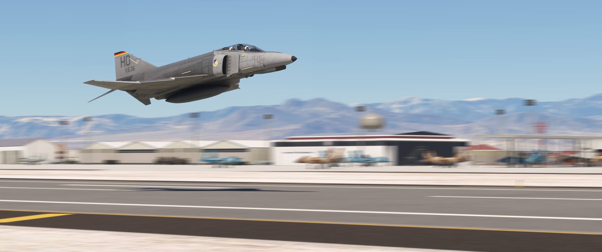
We started at Nellis Air Force Base (KLSV) in Las Vegas’s northeast suburbs and flew a 250-nautical-mile (460-kilometer) serpentine route across the Mojave Desert to the Southern California Logistics Airport (KVCV)–formerly George Air Force Base–in Victorville, California.

Pee-Wee says: We opted for a fast mover again to save time, and because the Phantom is freakin’ awesome. Here’s F-4E 75-636 gassed up and ready to go at Nellis.
The Luftwaffe’s first F-4F Phantom IIs were delivered in September 1973. Essentially simplified F-4Es with some German equipment, structural components, and license-built J79 engines, the German Phantoms weighed approximately 3,300 pounds (1,500 kilograms) less than their progenitors and lacked Sparrow missile capability.
Pee-Wee says: Eight of the Luftwaffe’s Phantoms were sent to the 35th Tactical Fighter Wing at George AFB, then the joint U.S. Air Force and Luftwaffe Phantom school. Those aircraft were eventually needed back home in Germany, so the Luftwaffe acquired ten new-build F-4Es as replacement trainers. 75-636 was the penultimate delivery and spent her entire operational life with the 20th Tactical Fighter Training Squadron at George and, from the early 1990s, Holloman AFB in New Mexico. She eventually became a maintenance trainer at Faßberg Air Base, Germany and was scrapped there sometime after 2007.
The German F-4Es were first painted in the Air Force’s Southeast Asia camouflage but later received standard low visibility grey with the West German tricolors atop their fins. The livery included in the DC Designs package represents 636 as she looked while stationed at Holloman.
Pee-Wee says: By the way, thanks to nickb007 for the wonderful rendition of Nellis, available at flightsim.to.
Anyway…let’s go flying! ![]()
![]() There’s A Fire: Wildfire
There’s A Fire: Wildfire
MSFS: 35.531 -114.891
Skyvector: 353152N1145329W
In the excellent screen adaptation of Michael Crichton’s novel The Andromeda Strain, the secret “Wildfire” biological research/weapons lab is located beneath a U.S. Department of Agriculture research station near “Flatrock,” a fictional township in the desert southeast of Las Vegas.
Pee-Wee says: Ever since Nag introduced me to the book and movie, I’d wondered about the lab’s real location. Thankfully, in the movie we briefly see Wildfire’s location overlaid onto a WAC or Sectional Chart, with a general aviation airport labelled “Searchlight” clearly visible. Somebody smash the “That Was Easy” button!

Here we are maneuvering south of Searchlight, Nevada, looking north. Las Vegas is in the distance above our Phantom. You can see (1) the approximate location of Wildfire in the Eldorado Valley, (2) U.S. Route 95 winding downhill toward Henderson, Nevada, (3) Searchlight, and (4) a fragment of the abandoned Barnwell & Searchlight Railway’s mainline. The Searchlight airport, likely where Dr. Dutton receives Dr. Leavitt before driving to Wildfire, is located south of town, just off the bottom of this screenshot.
Searchlight was founded shortly after gold was discovered here in 1897 by George Colton, whose Duplex Mine became the second most productive in the area. In the good years between 1902 and 1913, Searchlight’s mines quarried approximately 247,000 ounces (7,000,000 grams) of gold ore worth $225 million (€208 million) today.
Pee-Wee says: The Quartet Mine operated a narrow-gauge railroad running east to the Colorado River, but for many years most of the town’s gold output travelled in wagons to the Atchison, Topeka & Santa Fe Railway’s depot across the California border at Manvel (later renamed Barnwell). To aid commerce (and keep a budding competitor out), the AT&SF competed its 23-mile (37-kilometer) Barnwell & Searchlight Railway in 1907…just in time for the bottom to fall out of the local mining industry. The town and railroad limped along a few more years, but in 1923 a flood washed out the B&S’s tracks and service ended for good.
Searchlight was home to several famous Americans: former Speaker of the House Harry Reid was born here, while famed test pilot and three-time Mackay Trophy recipient John Macready and fighter pilot Lieutenant William Nellis, for whom Nellis AFB is named, both lived here until joining the USAAF during World War 2.
![]() There Goes the Neighborhood: Jean and the Southern Nevada Supplemental Airport
There Goes the Neighborhood: Jean and the Southern Nevada Supplemental Airport
MSFS: 35.688 -115.359
Skyvector: 354120N1152135W
Las Vegas’s Harry Reid International Airport (KLAS) needs serious help. I’ve personally spent many hours waiting at nearby airports during a “Vegas ground stop” because the winds were blowing from the east or there was a cloud over the airport. The problem comes down to the airport’s terribly inefficient runway arrangement, but with high terrain nearby and the city encroaching from every direction, there’s no fixing it.
Pee-Wee says: Sounds like it’s time for a new airport. ![]()
The Clark County Department of Aviation reached the same conclusion, and development of the Southern Nevada Supplemental Airport (formerly the Ivanpah Valley Airport) is already underway. Designed with two widely spaced parallel runways and 150 gates, the airport is scheduled to open in 2037, seven years after Reid is expected to reach its maximum passenger capacity.
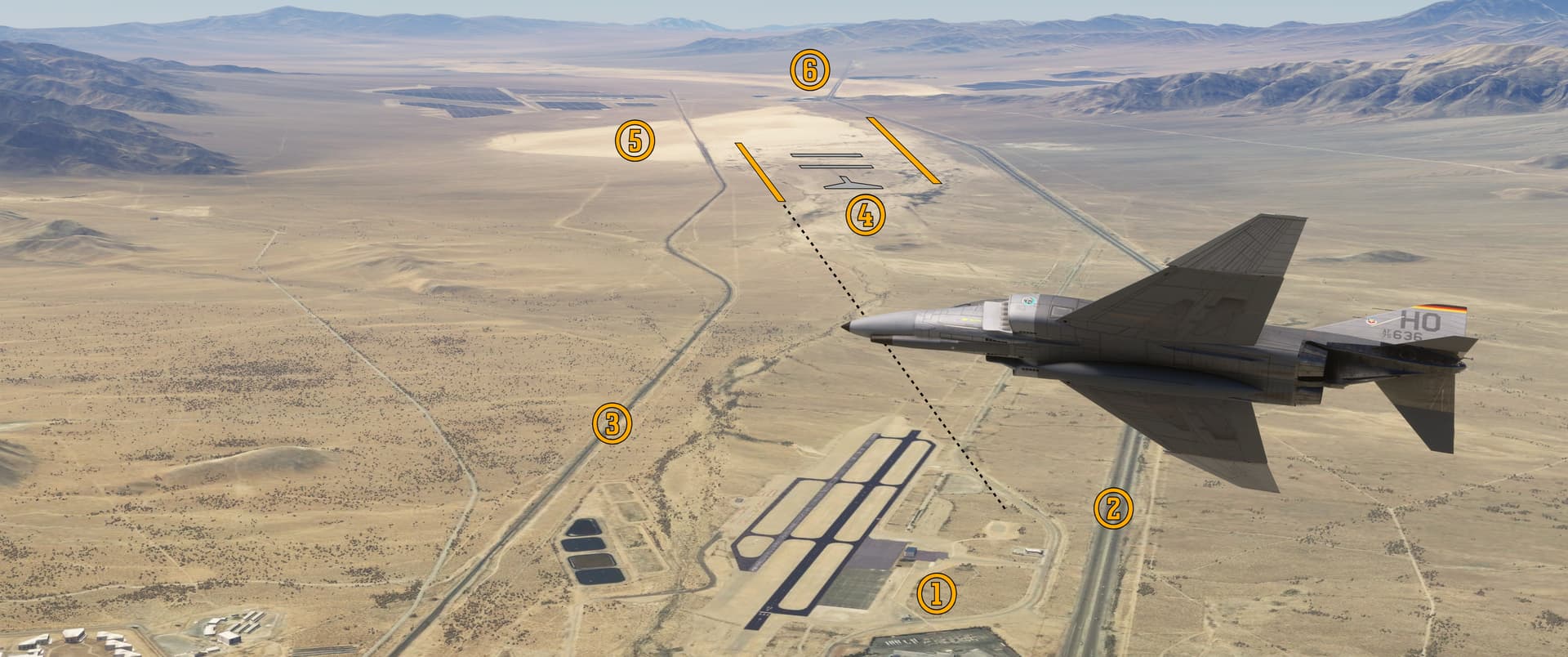
Pee-Wee says: We’re flying roughly east in this south-facing screenshot. Below our Phantom you can see (1) Jean Airport (0L7) and (2) Interstate 15. The Union Pacific Railroad’s (3) Cima Subdivision weaves southwest across the Mojave Desert to Yermo, California. In the distance I’ve drawn (4) a crude rendition of the SNSA’s runways (18L and the longer 18R) and proposed terminal layout. The new airport will cover most of (5) Roach Dry Lake and certainly impact (6) Primm, a casino town standing about 2.5 miles (4 kilometers) from the proposed threshold of Runway 36L.
The Jean Airport Sport Aviation Center is currently owned and operated by Clark County and maintained by staff from nearby Henderson Executive Airport. As the name suggests, most of the airport’s operations involve skydiving or aerobatics (the field hosted the 15th FAI World Advanced Aerobatic Championship in November 2023). Military contractor Blue Sky Training apparently uses the field, too, and its former BAe Strikemaster N2146J sits seemingly abandoned on the north ramp.
Pee-Wee says: In the screenshot, I marked the proposed Runway 18L’s extended centerline with a black dashed line. Aircraft landing at SNSA would pass about 500 feet above Jean’s traffic pattern. The Clark County Department of Aviation’s FAQ asks how Jean Airport will be impacted by its new neighbor. The official answer is: “The impacts SNSA would have on Jean Airport have not currently been determined.” That sounds bad, if you ask me. If you’re planning to visit Jean Airport, either in MSFS or real life, you probably should sooner rather than later! ![]()
![]()
![]() Greenbird and Green Energy: Ivanpah Lake
Greenbird and Green Energy: Ivanpah Lake
MSFS: 35.554 -115.399
Skyvector: 353318N1152358W
Ivanpah Lake is a 12-mile (19-kilometer) long closed basin famed for its nearly perfect land sailing conditions. The Bureau of Land Management maintains the Ivanpah Windsailing Special Recreation Management Area here.

Here we are turning west over the Ivanpah Lake. In the distance is (1) Primm, Nevada. The (2) Desert Stateline Solar Facility (“Stateline Solar”) photovoltaic power station abuts the lakebed’s northwestern shore, while the (3) Ivanpah Solar Power Facility hugs Clark Mountain and the Mojave National Preserve to the west. Further south on the lakebed is (4) a dirt track for buggies and dirt bikes.
Pee-Wee says: On 26 March 2009, Greenbird established a new world record for wind-powered land vehicles here, reaching 126.1 mph (202.9 kph) on a closed course (marked in red). British-born engineer Richard Jenkins designed Greenbird with a solid sail more reminiscent of an airplane’s wing than a traditional fabric sail.
The Ivanpah Solar Power Facility consists of three towered boilers and their associated reflector fields. Mirrors in the reflector fields rotate and tilt automatically to direct the Sun’s light onto the boilers, where the intense heat converts water to steam for driving specially-designed turbines. In 2020, Ivanpah produced approximately 860,000 MWh of electricity, more than 91% of its design capacity.
Pee-Wee says: There are some drawbacks to Ivanpah’s design. Temperatures inside the beams of solar energy can reach 1,000° Fahrenheit (538° Celsius), more than enough to kill or seriously burn passing birds. The most recent Federal study puts the number killed daily at about sixteen.
All that concentrated light also makes the boilers glow with sufficient intensity to cause permanent blindness to observers. Pilots and passengers should heed the warning printed on the Las Vegas Sectional Chart! ![]()
![]() Scarecrow’s School of Driving: Dumont Dunes
Scarecrow’s School of Driving: Dumont Dunes
MSFS: 35.676580 -116.237243
Skyvector: 354036N1161414W
In May 2012, while Curiosity was still enroute to Mars, the men and women that would pilot the rover were still determining its capabilities and, more importantly, its limitations. To assist their learning they travelled to the Bureau of Land Management’s Dumont Dunes Off-Highway Vehicle driving area north of Baker, California with a full-scale, stripped-down replica of Curiosity. Since it lacked a “brain,” the team named the replica Scarecrow.
Pee-Wee says: If you don’t get the reference or haven’t seen The Wizard of Oz, there’s nothing we can do for you. ![]()
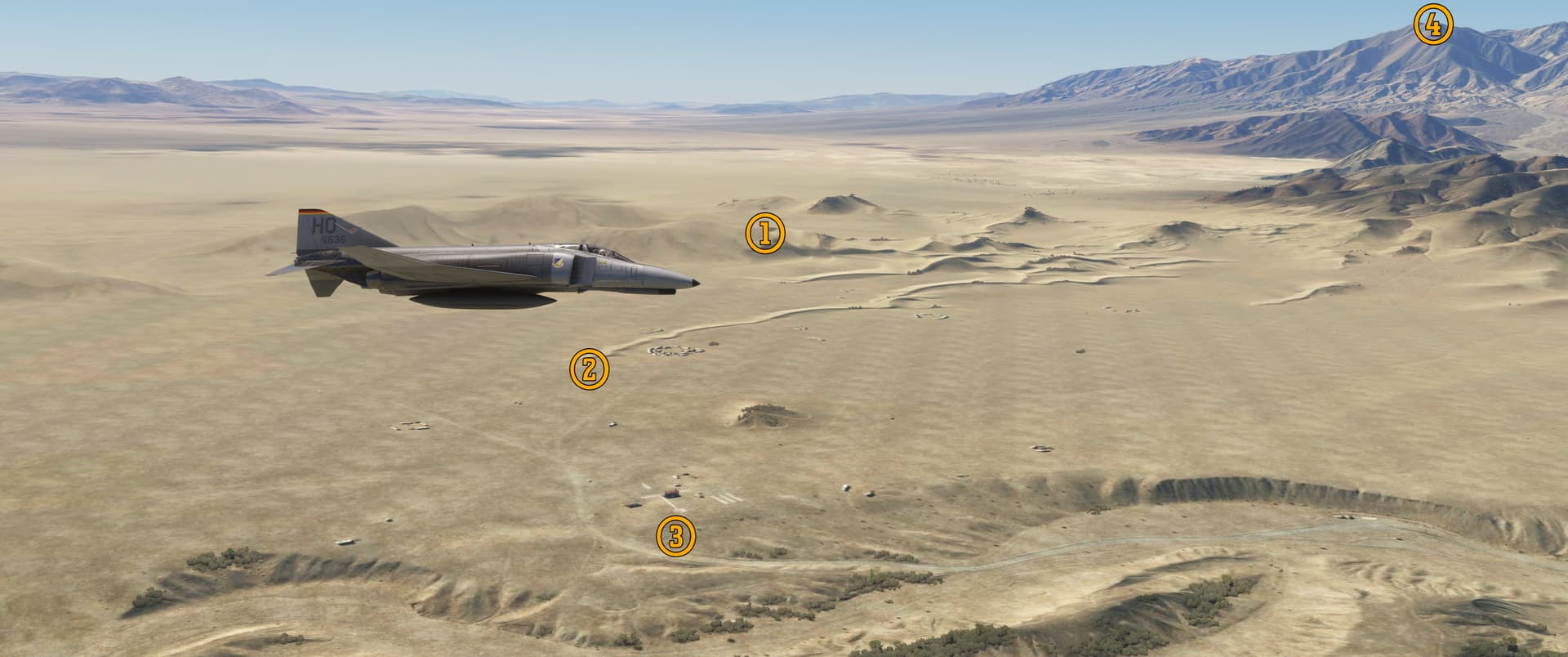
Pee-Wee says: Here we are flying west past the Dumont Dunes OHV Area. This spot is an off-road enthusiast’s dream, with high, sandy dunes, rocky crags, and decent facilities including restrooms! The JPL team conducted tests on the southwest side of (1) Competition Hill overlooking the “South Pole.” On peak days, hundreds of ATV riders flock to Dumont, although there’s (2) not many visible here in MSFS. Sorry, rotorheads: the (3) helipad isn’t “active” in MSFS, although it’s visible in the ground imagery. The 6,154-foot (1,876-meter) tall (4) Avawatz Mountains are visible in the distance.
Scarecrow survives today at the JPL’s laboratory near Pasadena, ready at a moment’s notice to help solve any problems that may arise with its much smarter brother.
Next time we’re bringing the Zenith out here. I saw a few spots screaming out for a STOL plane! ![]()
![]() The Last Word in Scams: Zzyzx
The Last Word in Scams: Zzyzx
MSFS: 35.1432 -116.1041
Skyvector: 350835N1160615W
Pee-Wee says: I learned two new words while researching this next location. The first, “nostrum,” is defined by Merrian-Webster as “a medicine of secret composition recommended by its preparer but usually without scientific proof of its effectiveness.” The second, “huckster,” is “one who sells or advertises something in an aggressive, dishonest, or annoying way.” That takes us to the fascinating story of “Doctor” Springer and his Resort!
Curtiss Springer, a medical doctor and Methodist minister, was neither a doctor nor a minister, an inconvenience that didn’t prevent him from travelling the United States espousing the health benefits of “clean living” and his “miracle cures.”
Pee-Wee says: “A Quack and His Nostrums” is how the American Medical Association referred to him. ![]()
Having been outed by the AMA, Springer faded into retirement in Los Angeles. Not content to sit around, he discovered the abandoned Army post and Tonopah & Tidewater Railroad station on the western shore of Soda Lake south of Baker in 1944 and immediately recognized the site’s potential. Springer got to work and, with help from vagrants recruited from the streets of Los Angeles, the Zzyzx Mineral Springs and Health Resort soon rose from the desert sands. It included a two-story castle, dining hall, library, dormitories, and a bath house. Springer requested donations from his guests, but never turned anyone away.
Pee-Wee says: Springer created the name so that his resort would be “the last word in health.” It’s pronounced “ZEYE-zix.” (The last word in the Oxford English Dictionary is “Zyzzyva,” a type of weevil, while Meriam-Webster ends with tiny Australian rodents called “Zyzomys.” Were “zzyzx” included in those dictionaries, it actually would be their last words!)
Springer’s resort survived thirty years before the powers that be intervened. To occupy the land back in 1944, Springer and his wife filed mining claims covering more than 12,000 acres (4,850 hectares) around Soda Lake. In 1974 the Bureau of Land Management determined that Springer was not actually mining the land and was therefore illegally squatting there. After some legal wrangling and several months in prison, Springer forfeited the land and all its structures. Two years later the BLM entered into an agreement with California State University, Fullerton to occupy and maintain the land. The school’s Desert Studies Center remains active today.

Pee-Wee says: Here we are flying south past the former Zzyzx Mineral Springs and Health Spa. Winding between Noels Knoll and Soda Lake is (1) Zzyzx Road, which connects to Interstate 15 at Exit 239 five miles to the north. The (2) “Zyport” runway seems to be built atop the former T&T roadbed and is active in MSFS, although it’s incorrectly named “Fort Irwin Airport” (KFOW). To the east of the public parking lot and runway threshold is (3) artificial Lake Tuendae, home of the endangered Mohave Tui Chub. CSU Fullerton’s Desert Studies Center occupies (4) the former resort structures south of the lake, overlooking (5) Soda Dry Lake.
Only the parking lot and trail around Lake Tuendae are open to the public. Visitors are asked to remain away from the Desert Studies Center’s facilities south of the lake.
Pee-Wee says: Remember the waypoint ZZYZX that started this whole tour? Oddly enough, it’s located about 70 nautical miles (130 kilometers) northeast of Zzyzx. If you’re flying the ANJLL 4 RNAV arrival, the old resort lies north of the track, between SHTNR and SMASH.
![]() From Gold Mines to Waveguides: Goldstone Deep Space Communications Complex
From Gold Mines to Waveguides: Goldstone Deep Space Communications Complex
MSFS: 35.359 -116.849
Skyvector: 352134N1165059W
(We’re not certain, but to see this site in MSFS, you’ll probably need PuffinFlight’s We Love VFR - Region 2 available at www.flightsim.to.)
NASA’s Deep Space Communications Network consists of three separate complexes: the Complejo de Comunicaciones de Espacio Profundo near Madrid, the Tidbinbilla Deep Space Tracking Station near Canberra, and the Goldstone Deep Space Communications Complex north of Barstow. The first station at Goldstone–Deep Space Station 11 “Pioneer”–was built by the Army’s Jet Propulsion Laboratory in 1958, just in time to support Pioneer 3’s failed mission to the Moon. Goldstone and the JPL were both transferred to the newly created NASA the same month.
The Army and NACA chose the remote desert near the Goldstone abandoned gold mining settlement because of its suitable terrain and distance from other terrestrial microwave radiation sources. (Pee-Wee says: Locating the facility inside the boundaries of the Fort Irwin National Training Center helps keep unwelcome visitors out, too ![]() ). The site consists of seven separate stations, including the decommissioned “Pioneer” station and the huge “Mars” station that received Neil Armstrong’s famous message about small steps and giant leaps.
). The site consists of seven separate stations, including the decommissioned “Pioneer” station and the huge “Mars” station that received Neil Armstrong’s famous message about small steps and giant leaps.
Pee-Wee says: And DSS-12, “Echo,” constructed in 1959 to support Project Echo, NASA’s experiments with “passive telecommunications satellites,” an idea first proposed by science fiction author Sir Arthur Clarke. NASA lofted two massive mylar balloons (Echo 1A and 2) into geocentric orbits over the United States, then bounced radio signals transmitted by DSS-12 off the balloons to a receiver at Bell Labs in Holmdel, New Jersey. The system worked wonderfully and paved the way for modern telecommunications satellites. Echo 1A and 2 fell back to Earth in 1968 and 1969, and DSS-12’s antenna was transferred to the “Venus” site where it is currently used for research and development. The original “Echo” site serves as Goldstone’s administrative center.
(“Blimps in space?” Yay! ![]() )
)

Pee-Wee says: Here we are passing the original “Echo” station westbound. You can see the 112-foot (34-meter) dish directly in front of the Deep Space Network Museum, and the “Goldstone” sign, which MSFS interprets as buildings. Goldstone is closed to the public, but there’s an official visitor center colocated with the Western America Railroad and Route 66 museums in Barstow. Depending on Nag’s schedule, we’re planning to visit in October.
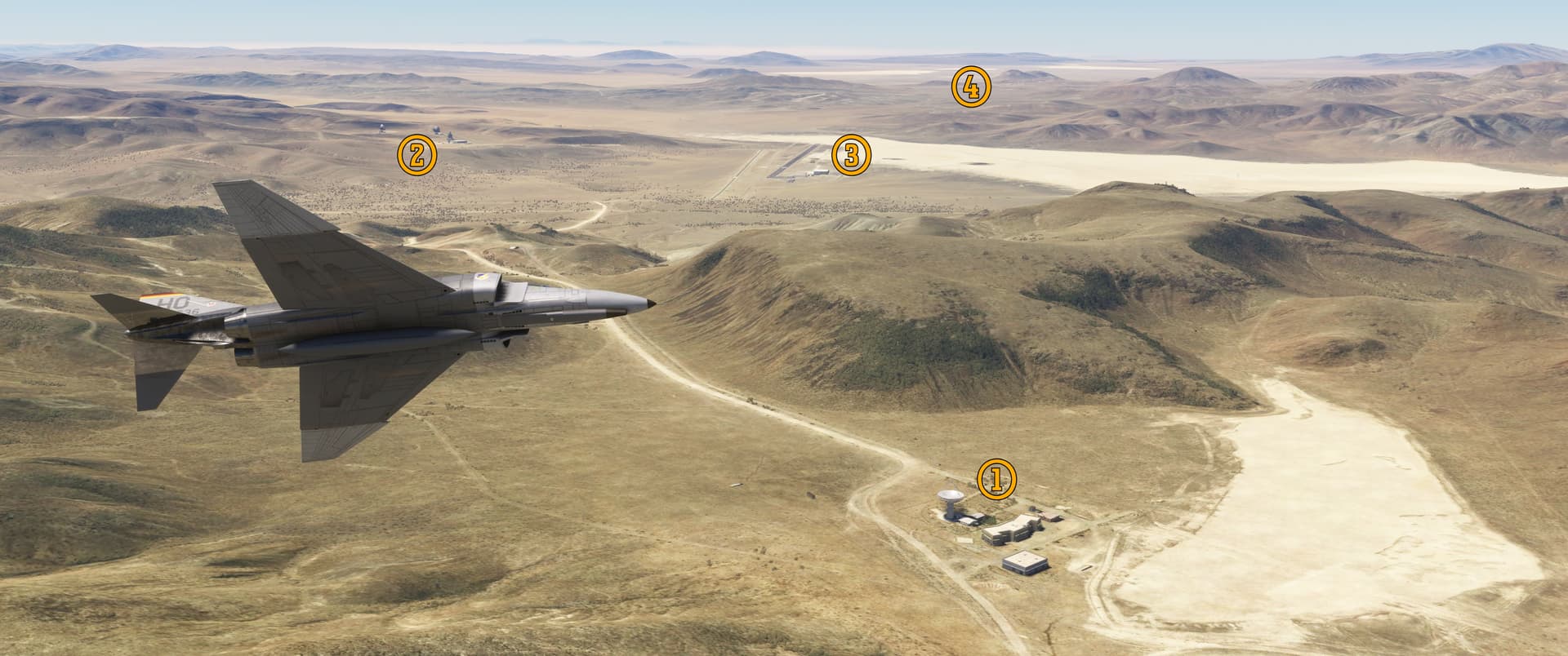
A few miles northwest of “Echo” we found (1) the original DSS-11 “Pioneer” station, now a National Historic Site, and (2) the “Apollo” site, where three (soon to be four) massive antennae communicate with spacecraft including the Voyager 1 and New Horizons interstellar probes, the Perseverance Mars rover, and the Juno Jupiter orbiter. Here on the eastern shore of Goldstone Lake is (3) the Goldstone Airfield (00CA), built for NASA but now apparently used by the Army’s 229th Aviation Regiment to train drone pilots and technicians. The Goldstone boomtown lay (4) south of the dry lake.
Pee-Wee says: Here’s something else I learned today. Because of its trajectory, Voyager 2 isn’t “visible” from Earth’s northern hemisphere, which means all communications with that probe are accomplished through the Tidbinbilla station in Australia.
![]() Toxic Town: Hinkley, California
Toxic Town: Hinkley, California
MSFS: 34.903 -117.158
Skyvector: 345412N1170932W
Pee-Wee says: Pay attention to this next paragraph. There will be a quiz. (Not really, but pay attention anyway. ![]() )
)
Pacific Gas & Electric (PG&E) maintains thousands of miles of natural gas pipeline serving approximately 4.2 million customers within California. Eight compressor stations maintain system pressure, from Topock on California’s southeastern border to Tionesta in the shadow of Mt. Shasta. The natural gas warms during compression and is subsequently directed into air/water heat exchangers to cool before being reintroduced into the pipeline. For many years, PG&E stored the cooling water in unlined ponds near the stations, and some seeped into the aquifer beneath. Unfortunately, PG&E added potentially toxic anti-rusting agents to the water, a fact never disclosed to local officials.
One of the pumping stations lies in Hinkley, California. Chemical dumping occurred there between 1952 and 1966.
Pee-Wee says: The award-winning movie Erin Brockovich tells the story of the eponymous clerk who helps represent the residents of Hinkley in a legal battle against PG&E, and the record-setting $333 million settlement ($634 million today) awarded in 1996. In researching this site, I delved further into the story and found that, like many “feel good stories,” there’s more to be told, including stories of corporate and scientific malficience and outright corruption. You can read about it here.

Here we are flying northwest toward Hinkley proper. The (1) compressor station lies generally southeast of town. These (2) water storage ponds were added between 1970 and 1984 and aren’t the infamous unlined ponds that started the whole mess. We weren’t able to determine where the original ponds were located. To curb further contamination, PG&E has purchased and demolished many homes in the area, leaving (3) street patterns where neighborhoods once stood. Across (4) State Route 58 are (5) other abandoned neighborhoods, although some crop and livestock farms remain.
Pee-Wee says: Hinkley is dying. The town is not directly surveyed by the Census Bureau, but the estimated population today is 600, down from 1,700 in 2010. Almost no houses have been built here since the contamination became public, and the only public school was shuttered in 2013. The compressor station remains in operation.
That’s ten screenshots, and there’s still two sites left. I guess it’s time for Part Two!
Pee-Wee says: Please standby… ![]()