Pee-Wee and Nag Over The 713
Houston, Texas City, & Galveston, Part 1
Welcome back, everyone! Today we’re heading to Houston, the fourth most populous metro area in America and the largest in Texas. Hey, Pee-Wee, what comes to mind when I say “Houston, Texas?”
Pee-Wee says: Violent crime.
Oh…okay…well, that’s not what I was thinking of.
Pee-Wee says: The smell?
Uh…no…
Pee-Wee says: Flash flooding? Toxic Superfund sites? Terrible public transit? A complete absence of zoning laws? Cheating at baseball?
Just stop.
Pee-Wee says: Ooh, I know! Humidity!
Spaceflight. I was thinking of spaceflight. The Johnson Space Center. NASA Mission Control.
“Houston, we have a problem.”
Pee-Wee says: Houston does have a problem.
Good grief. ![]() In all seriousness, Houston and Harris County have experienced explosive growth in previous decades and are still sorting themselves out. I’ve spent some time in the area, and unfortunately, Pee-Wee’s observations are mostly accurate. Houston will probably improve, but for the time being…it’s not our favorite place in the world.
In all seriousness, Houston and Harris County have experienced explosive growth in previous decades and are still sorting themselves out. I’ve spent some time in the area, and unfortunately, Pee-Wee’s observations are mostly accurate. Houston will probably improve, but for the time being…it’s not our favorite place in the world.
Pee-Wee says: But there’s quite a bit of history in Houston! Today we’ll see everything from a dreadnought that served in two world wars to the scene of one of the nation’s worst industrial disasters, and even the grocery store where Soviet Communism died.
No matter how you measure it, Houston is a big place. It’s approximately the size of Bahrain, larger than Greater London, and more than twice the size of Berlin. Its population is equivalent to that of Laos and only slightly below that of Switzerland. Petrochemicals are Houston’s economic lifeblood, and it hosts the largest concentration of petrochemical industries in the world.
Pee-Wee says: The aerospace industry is another big player in Houston. Two major airports serve the city: Bush Intercontinental in the northeast suburbs (a United Airlines hub) and Hobby Airport to the south (a Southwest Airlines “focus city.”) The National Aeronautics and Space Administration’s Johnson Space Center is here, too.
Quite a few famous Americans hail from Houston, including former President George Bush and his son, former President George Bush, cosmetics great Mary Kay Ash, famed “hellfighter” Red Adair, and mega-star Beyoncé.
Pee-Wee says: Patrick Swayze was from Houston, too.
Roadhouse!
Pee-Wee says: And Dirty Dancing! Mmmm. ![]()
You wanted to be Jennifer Grey, didn’t you?
Pee-Wee says: I wanted to be Patrick Swayze’s jeans.
Aaaanyway. Are you ready to go?
Pee-Wee says: I think so. We’ll start at Hooks Memorial Airport (KDWH) in our favorite JPL/WBSim Cessna 152 for this tour. She has good performance off the runway and in cruise, fuel efficiency, and an autopilot. What more could two digital tour guides want? ![]()

![]() The Blimps of Spring: Goodyear Blimp Airfield
The Blimps of Spring: Goodyear Blimp Airfield
Pee-Wee says: As if you didn’t already have an overdose of blimps from our last essay, this tour starts with a former blimp base! Opened in 1969 on 40 acres (16 hectares) west of Interstate 45 in Spring, Texas, Goodyear Tire & Rubber’s Houston blimp base initially housed a single, brand-new model GZ-20 blimp: N10A America, formerly the U.S. Navy’s L-8, the “Ghost Blimp.” The Houston base became Goodyear’s primary ■■■■■■■■ and maintenance facility, and the iconic Wingfoot Lake base was closed in 1972.
What the heck? I said ■■■■■■■■. ![]()
(Sorry, blimpologists. The forum software censors the accepted word for “the process of erecting an airship.” Use your imaginations.)
The new base boasted a 240 x 160-foot (73 x 49-meter) hangar, two 200-foot (61-meter) diameter mooring circles, and a public observation area. The 1990s heralded another realignment at Goodyear and the reopening of the Wingfoot Lake base. The Houston base closed in 1992.
Hey, did you know that this year (2025) is the 100th Anniversary of the launch of Pilgrim, the first Goodyear Blimp? ![]()
![]() First flown on 3 June 1925, Pilgrim’s gondola is on display today at the National Air & Space Museum in Washington, D.C.
First flown on 3 June 1925, Pilgrim’s gondola is on display today at the National Air & Space Museum in Washington, D.C.

Here we are circling north of the former Goodyear blimp base. You can see (1) the asphalt pad where the hangar once stood and the approximate locations of the (2) two mooring circles. The observation area lay parallel to the highway on the (3) northeast corner of the airfield. (4) Here’s Interstate 45 slicing through the Texas-sized car dealerships on its way to Dallas. Across the highway is (5) Spring High School, which also opened in 1969. Further east is (6) Union Pacific’s Lloyd Yard, and in the distance is (7) George Bush Intercontinental Airport.
Unfortunately, thanks to new construction in November 2024, the last remnant of this blimp base–the hangar’s asphalt pad–is gone. Look quick before Bing updates its imagery!
Pee-Wee says: Today the blimp base is also covered by Home Depot and Lowe’s home improvement stores, with a Firestone tire and auto repair shop tucked between. I wonder if the Firestone employees know they’re sitting on land once owned by their archrival? ![]()
The population of Spring has nearly tripled since the blimp base opened, and today more than 63,000 people live here. Olympic gymnastics phenomenon Simone Biles was born in Spring, and actor Jim Parsons was raised here.
Pee-Wee says: Next, we’re heading about 25 nautical miles (47 kilometers) to the southeast. Autopilot…activate!
![]() Fear Not, Texans: San Jacinto Battleground State Historic Site
Fear Not, Texans: San Jacinto Battleground State Historic Site
Pee-Wee says: Our next stop isn’t just the site of the final battle of the Texas Revolution, but one of the most important battles in world history, not for its own sake, but for what followed.
On 21 April 1836 Sam Houston’s Army of the Republic of Texas routed General Santa Anna’s superior Mexican Army on this marshy ground alongside the San Jacinto River and Buffalo Bayou. Santa Anna was forced to sign the Treaty of Velasco which paved the way for Texas becoming an independent nation, but the Mexican Government refused to honor that treaty, even after the United States annexed Texas in 1845. The Mexican-American War erupted the following year and resulted in the annexation by the victorious United States of nearly half of Mexico’s territory, including the current states of Arizona, California, Nevada, and Utah, and portions of Colorado, New Mexico, and Wyoming.
Pee-Wee says: The Battle of San Jacinto indirectly determined that the United States would be the dominant power in North America, and even the world. Ironically, the battle also nearly brought an end to the United States, as the annexation of the new territories reignited the internal political battle over slavery…and we all know where that argument lead! ![]()
In early Spring 1861, after chasing the rebel Texans eastward, Santa Anna cornered the Texan Army here but failed to seize the initiative. The Texans attacked the bivouacked Mexican Army, catching many of the soldiers asleep, and after only eighteen minutes of battle, the surviving Mexicans retreated south in defeat. The Mexican Government made overtures about reclaiming Texas, but its military never returned.
Completed in 1939, the 567-foot (172-meter) tall San Jacinto Monument honors the brave Texans who fought and died here. It’s the world’s tallest masonry tower and approximately 13 feet (4 meters) taller than the Washington Monument, the world’s tallest stone tower. In 1990 its base was rebuilt to house the San Jacinto Museum of History. The monument is open to the public Wednesdays through Sundays, from 9 a.m. to 6 p.m.
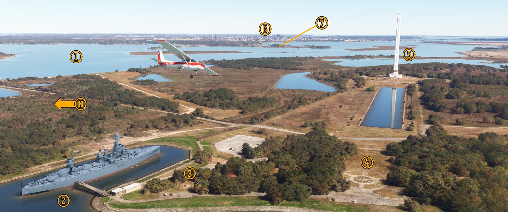
Pee-Wee says: Here we are circling northwest of the historic site at the confluence of the Buffalo Bayou and the (1) San Jacinto River. (2) BB-35 Texas is moored where Texas Army commanders Burleson’s and Sherman’s troops encamped on the eve of battle. This (3) obelisk marks the exact spot where General Santa Anna surrendered to the conquering Texans. Over here is the (4) de Zavala Cemetery. Mexican General Manuel Fernández Castrillón–Santa Anna’s aide-de-camp and a soldier respected by Mexicans and Texans alike–is interred here. The (5) San Jacinto Monument stands on the field of battle, the reflecting pool running toward the Texas Army’s battle line. In the distance is (6) Baytown and the (7) Baytown Nature Center.
Pee-Wee says: Commissioned in 1914, the ten-gun, 29,500-ton dreadnought Texas is the second U.S. Navy ship to bear that name. During her thirty-four-year career, she supported American troops at Veracruz, escorted the vanquished German fleet to Scotland at the end of World War 1, escorted vital convoys across the Atlantic as war clouds closed over Europe in 1939, and supported Allied landings in the Atlantic and Pacific Theaters. She was the first battleship fitted with 14-inch (356-millimeter) main guns, the first equipped with a fire control system, the first U.S. Navy ship to mount fixed anti-aircraft guns, and the first battleship to launch an aircraft for gunnery spotting. Texas spent 478 days in combat during World War 2, and was damaged only once, by German artillery fire off the coast of Cherbourg in June 1944.
The Navy donated Texas to her namesake state in 1946. She was officially decommissioned here on 21 April 1948, exactly 112 years after the Battle of San Jacinto. The years (and the water) weren’t kind to the ship, and by 2020 she was in critical condition, taking on water and listing heavily. In August 2022, she was towed to Galveston for restoration, and when complete, she’ll remain there at her new permanent home alongside Pier 20.
Like all battleships, Texas swapped her main guns during several overhauls. Today, through the quirks of fate and the Navy’s maintenance program, she mounts nine of her original 10-inch guns from 1914.
Pee-Wee says: An excellent website about Texas can be found here. You’ll need at least a few hours to read everything there! And when you read one officer’s happy recollection of Jim, one of the ship’s mascots, have a box of tissues ready. ![]()
![]() Highways and Dams and…Sub-Chasers?: Brown Shipbuilding
Highways and Dams and…Sub-Chasers?: Brown Shipbuilding
During World War 2, the U.S. Government realized that the nation’s manufacturers possessed unrivalled expertise in managing large-scale construction projects, and that factories and tradesmen building washing machines, tractors, and highways could be redirected quickly to build airplanes, radios, and airfields. As a result, Allied soldiers and sailors rode into combat aboard Waco gliders built by refrigerator manufacturers, Sherman tanks built by locomotive works, and warships guided by compasses built by toy train makers.
One of the many companies that helped produce nearly 6,000 warships for the U.S. Navy was Brown & Root, a Houston-based construction company specializing in civil infrastructure projects like the city of Austin’s Mansfield Dam. Holding a contract for a quartet of PC-461 Class submarine chasers, Brown & Root established its Brown Shipbuilding subsidiary at its new Greens Bayou Fabrication Yard located at the confluence of the Greens and Buffalo bayous east of Houston. Twelve of the 173-foot (53-meter) anti-submarine boats plus thirty-two Landing Craft Infantry and 254 Landing Ship Mediums would eventually slide down the Greens Bayou ways.
The largest ships built here were thirty-eight Edsall Class and twenty-three similar John C. Butler Class destroyer escorts. The first ship–DE-238 Stewart–was launched in November 1942. We’ll actually see her later in the tour.
Pee-Wee says: Perhaps the most famous DE of all is DE-413 Samuel F. Roberts, launched here on 20 January 1944. Roberts was attached to “Taffy 3,” the small force of escort carriers, destroyers, and destroyer escorts that fought a superior Japanese fleet off Samar during the Battle of Leyte Gulf. Lieutenant Commander Copeland lead his crew in a desperate hour-long last stand against the Japanese battleships and cruisers, fatally torpedoing the cruiser Chōkai before the battered destroyer escort–its magazines nearly empty–succumbed to enemy fire. Ninety crewmen died, while the 120 survivors waited two days for rescue. The “destroyer escort that fought like a battleship” lived only 180 days and now rests 60 miles (97 kilometers) east of the Philippines, 22,621 feet (6,895 meters) below the surface, the deepest shipwreck ever identified.
After the war, B&R sold the Greens Bayou facility to cross-channel neighbor Todd Shipbuilding but returned in the late 1980s to build equipment for the offshore oil industry. Work stopped in 2004 and the facility was sold piecemeal to various industrial firms. Today it’s known as the Brown Shipbuilding Industrial Park.

Pee-Wee says: We’re flying west along Buffalo Bayou (part of the “Houston Ship Channel”) toward Houston proper in this southeast-facing screenshot. The submarine chasers and destroyer escorts were built on the (1) ways here and launched sideways into (2) Greens Bayou (the red line marks the original shoreline), then towed to the (3) finishing docks on (4) Buffalo Bayou. Todd Shipbuilding and the Kaiser Corporation built 208 Liberty ships and 14 T1 tankers at the (5) government shipyard on the former Irish Bend Island. The (6) 1,560-foot (480-meter) Sam Houston Tollway Ship Channel Bridge opened in 1982 but is slated for replacement in 2027. Crossing the bridge will cost you $1.50 (€1.38) in your car or between $4 and $6 (€3.67 and 5.50) in your RV.
The (7) San Jacinto Ordnance Depot was responsible for shipping, receiving, inspecting, and storing all ammunition passing through the ports of Houston and New Orleans during World War 2, and continued to store conventional and chemical weapons until 1959. Today the 4,954-acre (2005-hectare) site remains highly contaminated, but don’t worry: the Department of Defense estimates remediation will cost less than $7 million (€6.4 million) and should be complete by 2084. (Nope, not making that up ![]() ).
).
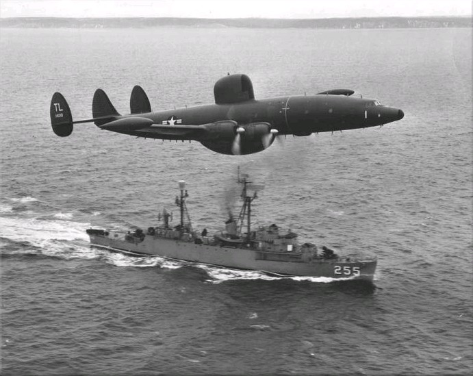
Pee-Wee says: Many of you have probably seen this famous photo of ill-fated Lockheed WV-2 BuNo. 141310 “buzzing” the radar picket ship Sellstrom off Newfoundland. Sellstrom started life as Edsall Class DE-255 and was launched by Brown Shipbuilding on 12 May 1943, the last of the shipyard’s original eighteen destroyer escorts.
Let’s continue west toward downtown. Spoiler alert: everyone check for obstructions and the minimum safe altitude in this area. ![]()
![]() H-Town Downtown: Houston’s Central Business District
H-Town Downtown: Houston’s Central Business District
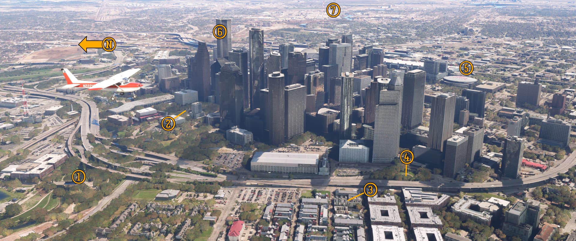
We’re passing downtown Houston southbound in this east facing photo. Here’s (1) Eleanor Tinsley Park, part of the Buffalo Bayou Park. Yes, that’s the same Buffalo Bayou, flowing slowly eastward to the Gulf of Mexico from its headwaters near Katy, 28 miles (45 kilometers) to the west. Over here behind the red-roofed Hobby Center for the Performing Arts is (2) Tranquillity Park. It’s named not for the peace and relaxation you’ll find here, but for the Sea of Tranquility, landing site of Apollo 11 where men first set foot onto the Moon. Neil Armstrong’s famous quote is engraved in fifteen languages on bronze plaques near the park’s entrance. The undulating landscape and multi-level fountain is designed to resemble the Moon’s landscape, and is punctuated by tall columns that resemble Saturn V rocket first stage boosters.
Pee-Wee says: We’re not sure why, but the park’s name is intentionally misspelled, adding a second “L.” ![]()
At the corner of Andrews and Crosby streets is (3) the Bethel Baptist Church Park. Built in 1923 and abandoned during the late '90s, this Gothic Revival-styled building burned in 2005, leaving only its outermost walls and edifice standing. The City of Houston purchased and stabilized the building four years later and repurposed it into a public park complete with seating and fountains within the confines of the original structure.
Pee-Wee says: Here’s a curious place. This is (4) Harmonica Man Park, jammed into the armpit of Brazos and Pease streets and Interstate 45. We searched the Internet high and low but couldn’t find a reason for the park’s name. If anyone knows, please respond below or drop a PM. Thanks! ![]()
Armpit? Is that a technical term?
Pee-Wee says: No, but you can picture exactly what I’m talking about, can’t you? ![]()
Fair point. Anyway, this is (5) the 18,000-seat Toyota Center arena, home of the NBA’s Houston Rockets. Across town is (6) the 1,002-foot (305-meter) JPMorgan Chase Tower, the tallest building in Texas and the world’s tallest five-sided building, although not a regular pentagon. In the early 1980s, building heights in downtown were capped to protect Hobby Airport’s airspace, so it seems the JPMorgan Chase building will maintain its superlative for years to come.
Pee-Wee says: Alright, everyone, we’re going to talk about an airplane crash next. Skip ahead to ![]() if you want, or click on the blurred text to read on.
if you want, or click on the blurred text to read on. ![]()
On 20 October 2024 Robinson R44 helicopter N881KE collided with (7) this 1,003-foot (306-meter) tall, guyed mast on Navigation Boulevard between Middle and North Velasco streets. The pilot and three passengers were killed, and the helicopter was destroyed. The mast collapsed, but thanks to either a miracle or superb engineering, the twisted wreckage landed completely within the confines of the transmitter property, preventing further loss of life.
Built in 1967, TelevisaUnivision sold the tubular steel mast to SBA Communications, an international wireless infrastructure leasing company, only weeks before the accident.
Several local news helicopter pilots testified that the mast’s lights were often inoperative. SBA remotely monitors its towers and masts–including obstruction light status–but because this tower wasn’t yet integrated into the monitoring system, the company instead ensured that a FAA Notice to Airmen was published stating that the lights were inoperative. The pilot of N881KE had flown the intended route numerous times, but it’s unclear if she was aware of the NOTAM. Regardless, many television and online “experts” quickly blamed SBA and the inoperative lights for the accident…until videos appeared which showed that the lights were indeed working.
Pee-wee says: More recently another theory appeared. Shortly before the crash, an air traffic controller warned N881KE’s pilot of another helicopter flying near Downtown. It’s possible that the pilot mistook the topmost flashing red obstruction light for the other helicopter’s beacon and didn’t realize she was flying directly toward the mast. The obstruction light may have actually prevented the pilot from recognizing and avoiding the mast.
The mast remains marked on aeronautical charts but will likely not be rebuilt.
Pee-Wee says: Only a few months before its destruction, the mast became Exhibit A in a controversy involving the Houston Housing Authority’s 800 Middle Street low-income housing project 500 feet (153 meters) to the north. Lawyers representing surrounding property owners claimed that the HHA intentionally misquoted the height of the mast as 306 feet instead of the actual 1,003 feet in order to secure federal funding and sought to stop the 800 Middle Street project altogether.
The tower was 1,003 feet tall…or 306 meters. Is it possible that instead of the error being the result of a deep-rooted conspiracy reaching into the highest strata of the city council that someone simply put the wrong number on the paperwork? Sheesh. No wonder our legal system is bogged down. ![]()
Well, that’s enough death and destruction…for now.
Pee-Wee says: Oooh. Foreshadowing. ![]()
![]() It’s All Fun and Games Until the President Shows Up: Hermann Park and Rice University
It’s All Fun and Games Until the President Shows Up: Hermann Park and Rice University
Here we are flying south-southwest approaching 445-acre (180-hectare) Hermann Park southwest of downtown. Opened in 1914 this public park suffered through a period of neglect in the 1990s but has since experienced sustained revitalization thanks to the non-profit Hermann Park Conservancy.
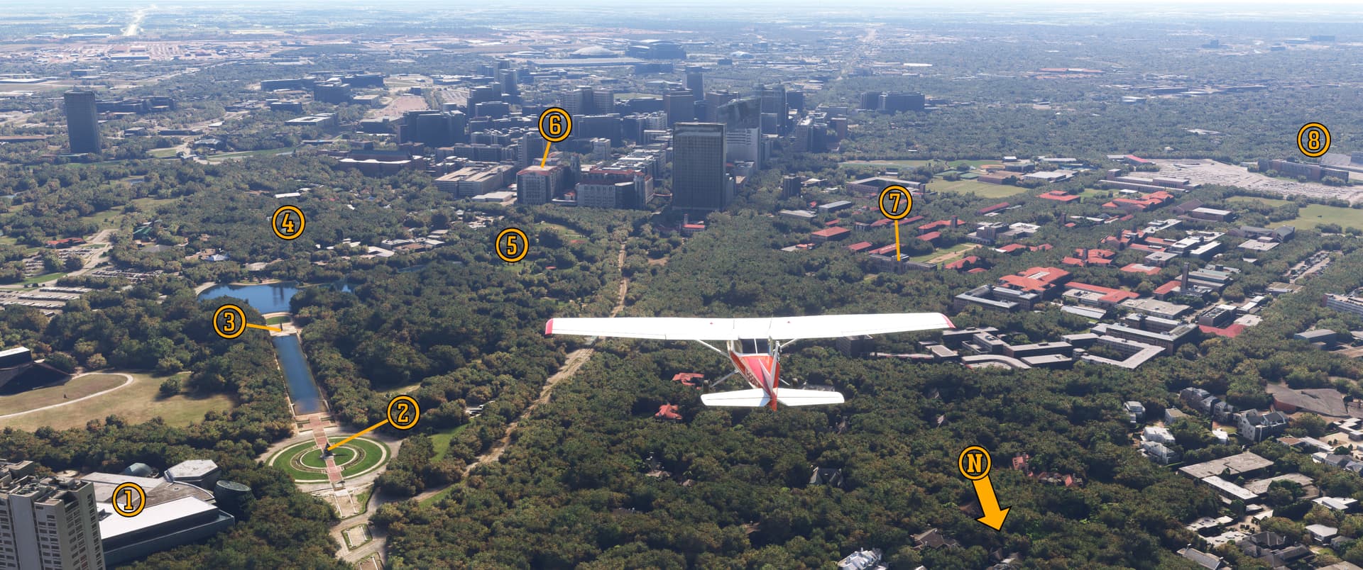
This modern building is (1) the Houston Museum of Natural Science, home to an impressive dinosaur gallery, butterfly house, and spaceflight-related galleries. It’s the ninth most visited public museum in the United States, and the most visited outside of New York City and Washington D.C.
Hermann Park’s main entrance is guarded by sculptor Enrico Cerracchio’s (2) bronze sculpture of Sam Houston riding atop his trusty war horse, Saracen.
Pee-Wee says: Some sources say that Sam is pointing toward the battlefield where he defeated Santa Anna’s army. Always dubious of such claims, I turned to Google Earth and determined that while he is riding toward the battlefield, he’s actually pointing roughly toward Galveston. Oh well. ![]()
Incidentally, the word “Saracen” originally referred to the peoples living in the Arabian Desert, and later specifically to those practicing Islam. It was generally replaced by the word “Muslim” in common usage between the 15th and 17th Centuries.
Pee-Wee says: Sam’s horse may have been an Arabian. If so, isn’t that like naming your Golden Retriever, “Golden Retriever?”
I suppose it is.
Pee-Wee says: Darn. I hoped “Saracen” was the name of a conquering hero of yore or maybe a mythical beast of battle. Total letdown.
Such is the danger of historical research! Anyway, across the reflecting pool is the (3) Pioneer Memorial Obelisk. Placed here in 1936 on the centennial of Texas’ independence, the granite spire is a miniature replica of the Washington Monument sculpted by stonemason Frank Teich. Further south is the (4) 55-acre (22-hectare) Houston Zoo, the second most visited zoo in the United States, and the new (5) Buddy Carruth Playground for All Children, where you’ll find an outer space-themed playground, a water park, and several pavilions.
Pee-Wee says: Including the Houston Astros Foundation’s pavilion. Unfortunately, there are no signs guiding you there: they were stolen. ![]()
Ouch! In the distance is the Memorial Hermann Medical Center. Our helicopter pilots (and readers in STOL birds) can try landing on the (6) four-pad John S. Dunn Heliport (ID: 38TE). It’s not an airfield in MSFS but is landable…sort of. Expect to sink into the surface slightly. Good luck!
Pee-Wee says: Across Main Street is Rice University, founded in 1912 with an endowment from businessman William Rice. (7) Lovett Hall, the campus administration building, was the first structure built here. It’s long and narrow–300 x 50 feet (92 x 15 meters)–to help keep the inside ventilated during sweltering Texas summers.
Southewest of campus is Rice Stadium, home of the NCAA Division 1 “Owls.” It was here that President John F. Kennedy kickstarted Project Apollo with the words “we choose to go to the Moon” on 12 September 1962.
Are you going to play nice at the next stop?
Pee-Wee says: All signs point towards “maybe.”
Our Houston-based readers are probably getting tired of it.
Pee-Wee says: What?! I can’t hear you! Someone keeps banging a trash can! ![]()
![]() A Sign of the Times: Houston Astrodome
A Sign of the Times: Houston Astrodome
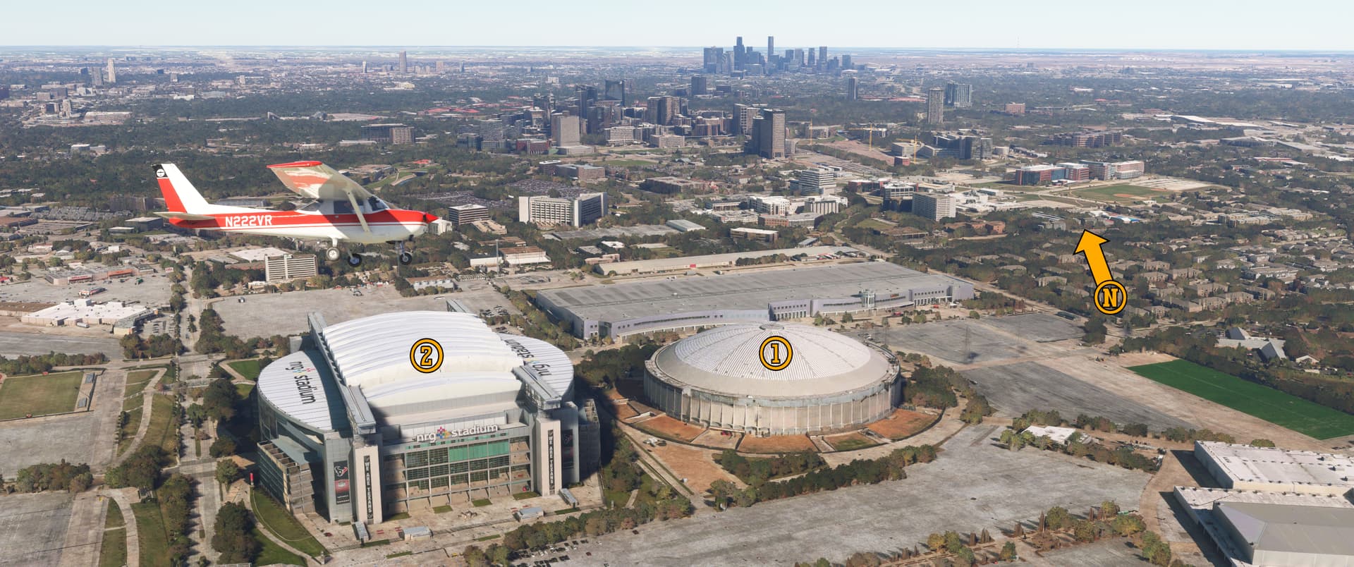
Pee-Wee says: We’ve flown a few miles further south here (that’s Hermann Park and Downtown Houston in the distant north). Below is the famed (1) Houston Astrodome, the world’s first multi-purpose domed stadium. It opened in 1965 and was home to the Houston Astros major league baseball team, and later the Houston Rockets and the American Football League’s Houston Oilers.
Deprived of natural sunlight by the roof, the original live grass field died in the first year and was replaced in 1966 with Monsanto’s new “ChemGrass” short-pile artificial turf. Capitalizing on the publicity surrounding the new installation–the first at a major sports venue–Monsanto changed the product’s name to “AstroTurf.”
That was a sound marketing decision. ![]()
The Astrodome hosted other events, including the Houston Livestock Show and Rodeo and concerts by A-listers like Elvis Presley, George Strait, and Selena. But by 1995, the stadium was in bad shape and, and unable to secure a new building from the city, the Oilers left for Nashville in 1996. The Astros moved downtown in 2000, and the rodeo joined the new Houston Texans NFL football team at the neighboring (2) Reliant Stadium in 2003, leaving the Astrodome without a permanent tenant. It remained virtually vacant until 25,000 New Orleanians were temporarily housed here after Hurricane Katrina’s disastrous landfall in 2005.
Three years later the Astrodome was found noncompliant with numerous design codes and closed. Since then, the City of Houston has developed several plans to resurrect the decaying building, but none have come to fruition. Today the iconic dome is used only for equipment storage, and its future remains uncertain.
Pee-Wee says: For those who don’t get the jokes about stolen signs and trash cans, here’s a primer. I’ll leave it at that. ![]()
We’re about halfway. This seems like a logical time for a break, doesn’t it?
Pee-Wee says: I think so, since the next few stops really go together. Thanks for tuning in everyone! We’ll have Part 2 posted shortly. ![]()