Pee-Wee and Nag over Northumberland and Cumbria
Hadrian’s Wall, Part 2
Welcome back, everyone! In this second part of our Hadrian’s Wall tour, we’ll look at the wall’s design and construction, and specifically the parts you’ll see in MSFS.
Pee-Wee says: Think of this as your primer for Part 3. ![]()
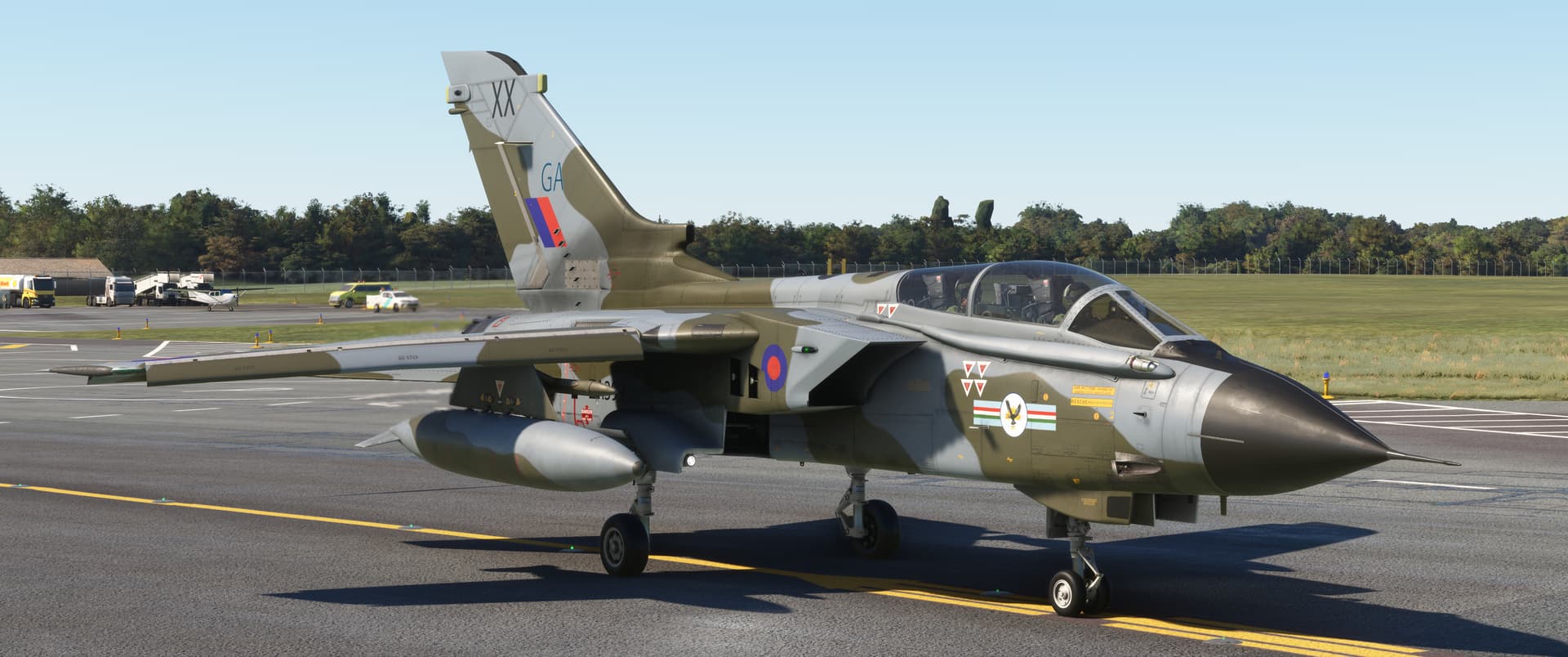
Pee-Wee says: Nag did, in actual fact, choose an awesome looking airplane! This is Tornado GR.1 ZA399, the 66th British-built airframe. She flew twenty-four missions over Iraq and Kuwait during Operation Granby and appears here as she did in 1992 during 20 Squadron’s disbandment parade. Her “nameplate” crew—Squadron Leader Batson and Wing Commander Heath—flew together during Op Granby, notably scoring an aerial “kill” using the JP233 airfield denial weapon (not in this aircraft).
Notice anything unusual about her markings? If you said “golly, Pee-Wee, her squadron badge is where the RAF roundel should be, and the roundel is on the intake,” you’re correct, you eagle-eyed mega nerd. ![]() 20 Squadron received special permission for the change in 1989.
20 Squadron received special permission for the change in 1989.
ZA399 was later modified as a specialized anti-ship GR.1B and served until 2001 with 617 Squadron at RAF Lossiemouth. Restored by Jet Art Aviation, she was displayed at RAF Cosford and then outside Oliver Valves in Knutsford, Cheshire, but has apparently been relocated recently. Does anyone know where she went? ![]()
You can thank talented texture artist lowlevelRAF at flightsim.to for this excellent skin.
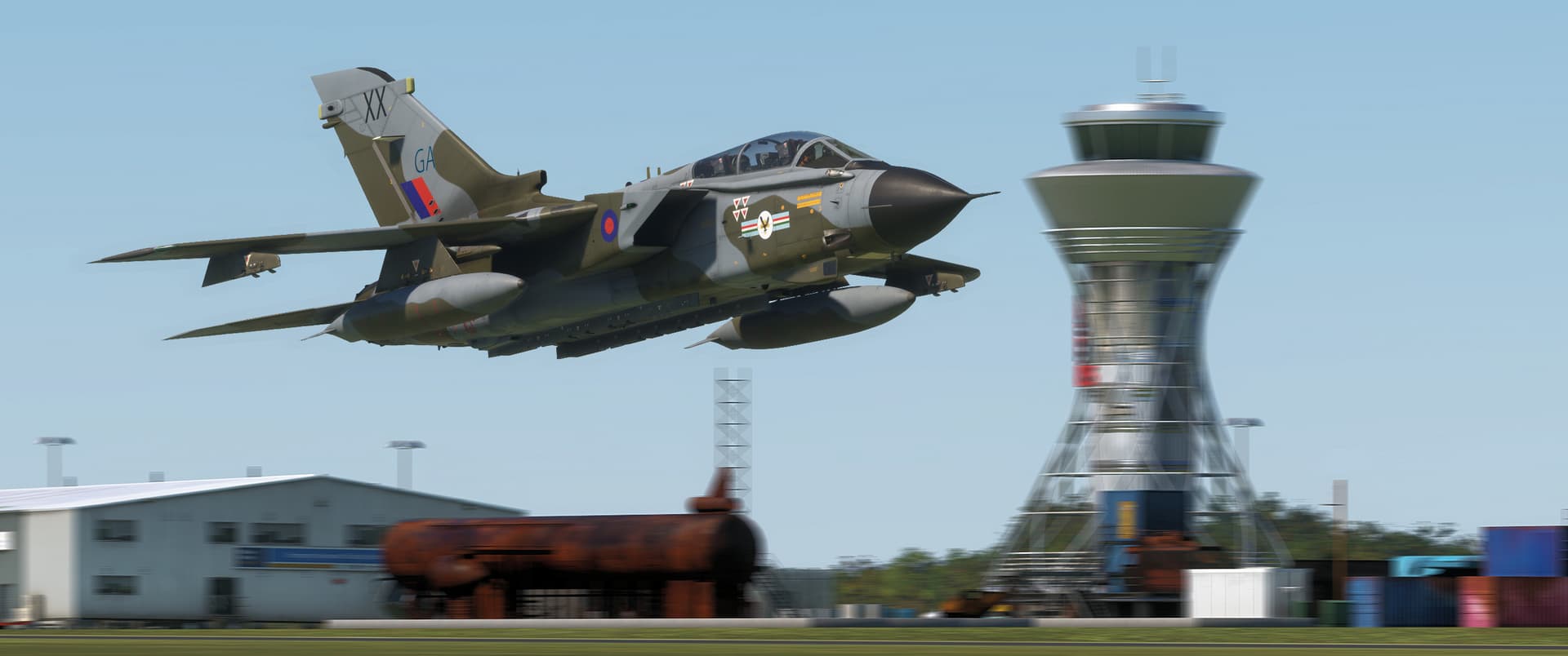
Here’s the waypoints for this tour. We were new to the IndiaFoxtrotEcho Tornado, so we strapped on two 1,500-gallon (5,678-liter) tanks. They weren’t necessary, but you can never have too much gas!
| Waypoint | Coordinates | Lat/Long (Skyvector) |
|---|---|---|
| Milecastle 30 / Procolita | 55.0378 -2.1985 | 550216N0021155W |
| Milecastle 33 / Shield on the Wall | 55.0300 -2.2698 | 550148N0021611W |
| Milecastle 42 / Whin Sill | 54.9953 -2.4340 | 545943N0022602W |
| Milecastle 50 / Turf Wall | 54.9858 -2.6185 | 545909N0023706W |
Alright, that’s enough talking. Ready back there?
Pee-Wee says: Pen, paper, panties, popcorn. All set. ![]()
Uh…roger that.
![]() Hadrian’s Design
Hadrian’s Design
Pee-Wee did most of the research for this tour, so I’ll let her handle this part.
Pee-Wee says: Move over. ![]() Okay, let’s start with the basics. There are five parts of Hadrian’s Wall you can see in MSFS with TMD’s HW180 installed.
Okay, let’s start with the basics. There are five parts of Hadrian’s Wall you can see in MSFS with TMD’s HW180 installed.
The Wall itself was built with shaped stones and stood roughly 15 feet (4.6 meters) tall and either about 8 or 10 feet (2.4 or 3.0 meters) wide, with the earliest built portions being widest. It was likely topped with a curtain wall, embrasures, and a wall-walk, and may have been limewashed white. If you don’t have the HW180 scenery, look carefully in MSFS’s base scenery and you’ll see the wall’s ruins.
The V-shaped Wall Ditch ran parallel to the wall’s north face. It was roughly 28 ft (8.5 m) wide and 9 ft (2.75 m) deep, possibly filled with obstacles (i.e. “sharp, pointy things”), and ran the full length of the wall except in areas where natural obstacles like the crags of the Whin Sill made it unnecessary. Portions of the ditch are visible in MSFS’s base scenery.
The Milecastles were small forts built every Roman mile (about 0.9 statute miles or 1.5 kilometers) along the wall’s length. They had entry gates to the north and south and were manned by 12 to 20 soldiers.
Between the milecastles were two evenly spaced 30-foot (9-meter) tall Turrets, each manned by four to six soldiers.
Large Forts were built roughly every seven Roman miles (6.5 statute miles, 10.4 kilometers) along the wall. About 600 soldiers were stationed at each fort.
Each fort fostered a surrounding civil settlement called a Vicus. Only those at Verovicium and Vindovala (modern Housesteads and Rudchester) are included in HW180. The remainder will be added in a future update.
The Vallum was an earthwork south of the wall. It was basically an obstacle, a “super ditch” 20 ft (6 m) wide and 10 ft (3 m) deep and bounded by mounds. Causeways crossed the vallum at each fort. Like the wall ditch, portions of the vallum are visible in MSFS’s base scenery.
A road—the Military Way—ran atop the northern mound or across the land between the vallum and the wall.
The distance between milecastles, turrets, and forts didn’t vary unless necessary due to the terrain. Regardless, the spacing meant that anyone attempting to sneak across the frontier was never more than about 900 ft (274 m) from Roman soldiers.

Pee-Wee drew this schematic showing the wall’s general arrangement. (PW says: Not to scale!) The vallum is highlighted yellow. It was approximately 100 feet (30 meters) wide and was built between 100 and 2,300 feet (30 and 700 meters) south of the wall.
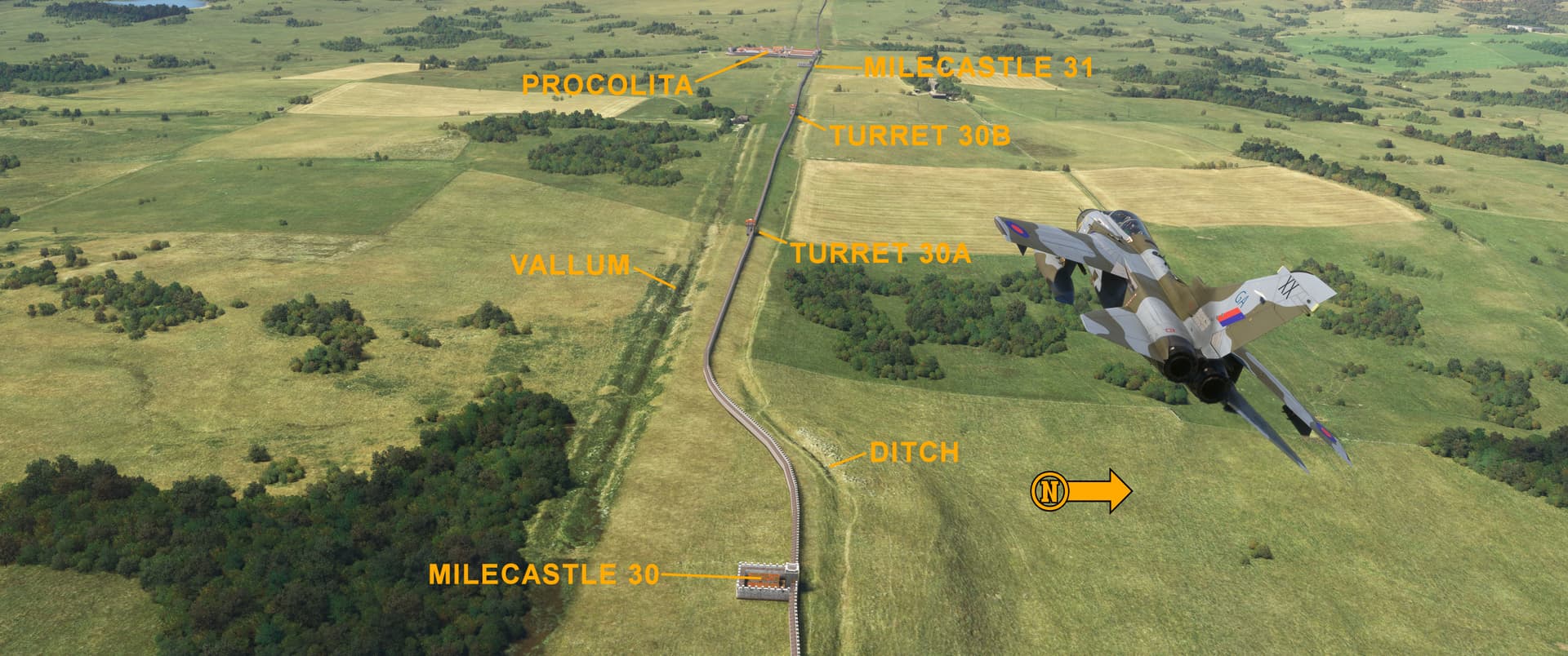
Here we are flying west in the vicinity of Chesters house and the village of Walwick. The guys at TMD blended the wall into the existing scenery perfectly! Notice that the spacing of the milecastles and turrets is unaffected by the intrusion of Procolita (modern Carrawburgh): MC.31 is within spitting distance of the fort! Also notice how the vallum doesn’t exactly parallel the wall near MC.30.
Pee-Wee says: The pattern of one milecastle and two turrets repeated along the wall’s entire length in a pattern that TMD’s team and other users have referred to as “hypnotic!” ![]()
![]() Construction
Construction
Three Roman Army legions—approximately 16,000 men—were tasked with building Hadrian’s Wall: Legio II “Augustus” from Isca (modern Caerleon, Newport, Wales), Legio VI “Victrix” from Eboracum (modern York, North Yorkshire, England), and Legio XX “Valeria Victrix” from Deva Victrix (modern Chester, Cheshire, England). Work began in 122 AD and was completed by 128 AD.
Pee-Wee says: Roman legions were divided into ten cohorts, and each cohort was further divided into six centuries. Think of a legion as a modern regiment, a cohort as a battalion, and a century as a company.
The original stone wall stretched from the River Tyne at Wallsend near Newcastle to Milecastle 49 near Gilsland, with a turf wall continuing west to Bowness-on-Solway. The turf wall was rebuilt with stone sometime between 160 and 180 AD.
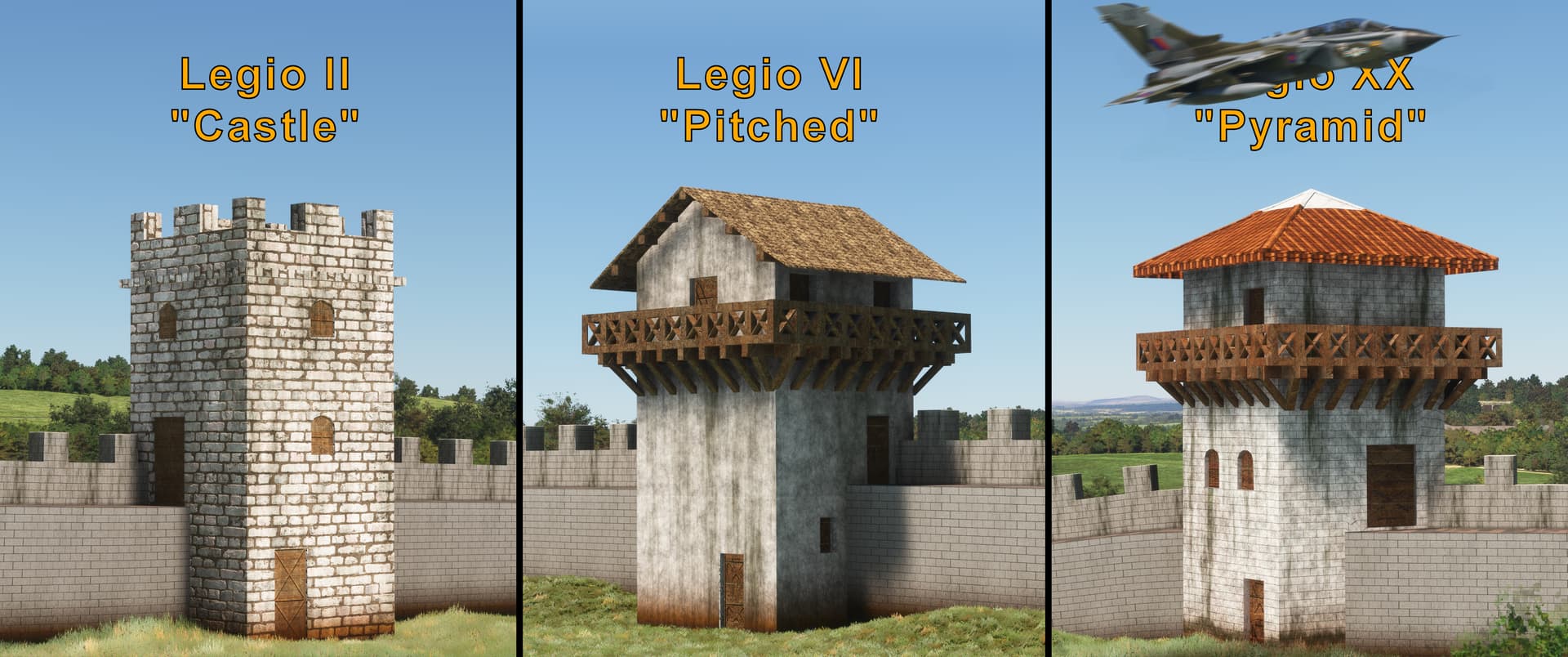
Pee-Wee says: The guys at TMD assigned an architectural style to each legion as seen in the photo above, then determined which legion built each turret, milecastle, and fort. The legions shared the construction work, so you’ll see all three styles along the wall’s entire length.
Now that’s a fanatical commitment to accuracy.
Pee-Wee says: It sure is. Hey, wanna’ keep the jet out of the way? I’m trying to type here. ![]()
Just providing some scale. ![]()
![]() Overview
Overview
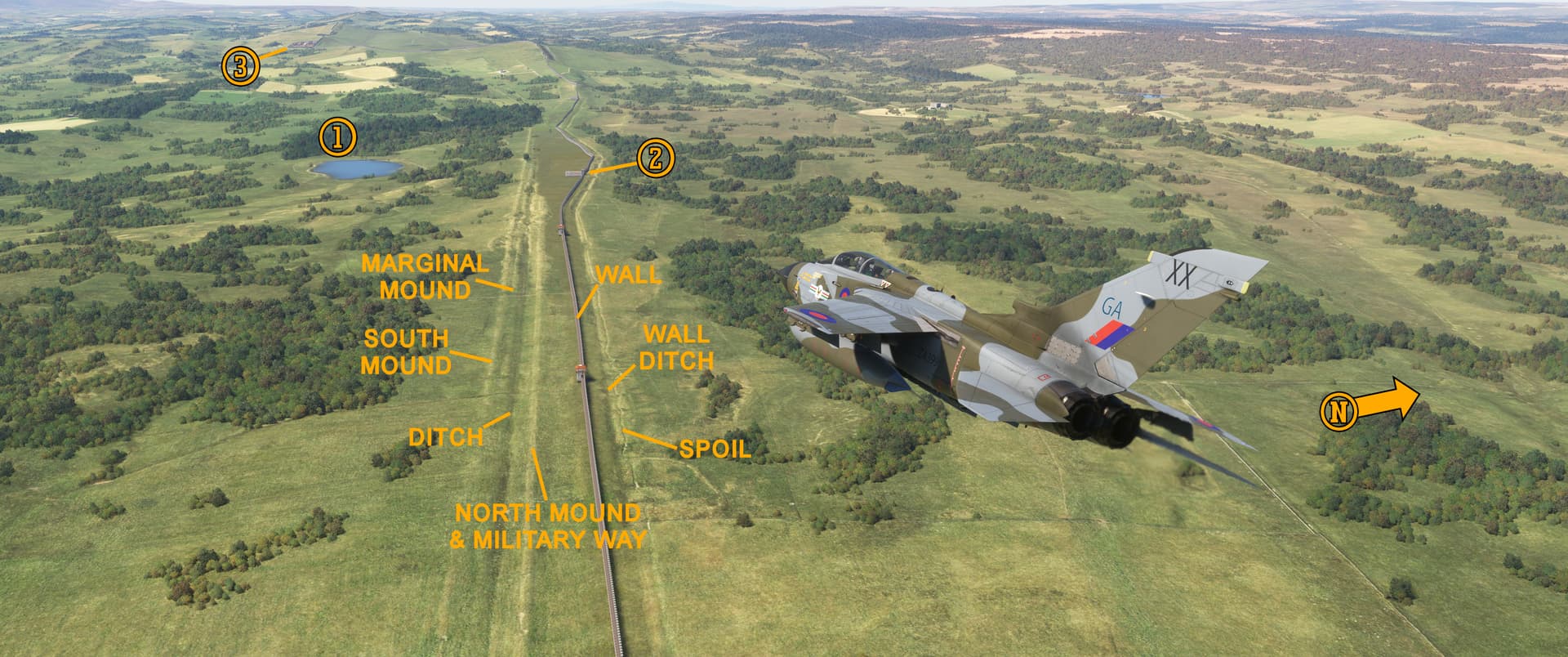
Pee-Wee says: We’re in the vicinity of (1) Shield on the Wall Dam and (2) MC.33, one of several excavated milecastles visible today. In the distance is (3) Verovicium (modern Housesteads), the ruins of which have been extensively excavated and are open to the public today. The wall ditch, vallum, and even portions of the Military Way are visible along this stretch. The guys at TMD did a masterful job of removing the B6318—the “Military Road”—which follows the wall’s path here. This looks like a good place to stop in Part 3.
The Military Road (not to be confused with the “Military Way”) was built between 1751 and 1758 to facilitate the movement of military forces between Newcastle and Carlisle, and runs for long stretches atop the remains of Hadrian’s Wall. Only the road’s divergence southward west of MC.33 at Sewingshields saved the remainder of the wall from destruction.

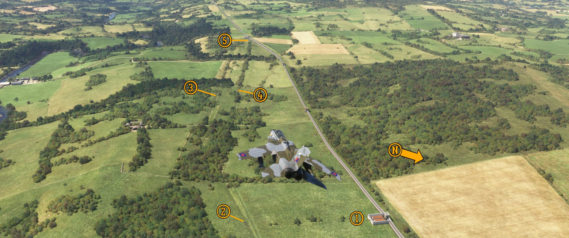
Pee-Wee says: We’ve flown further west along the Whin Sill to MC.42 in this east-facing photo. With the wall built atop the (1) towering crags, there was no need for a wall ditch. (2) Here is the Military Way, slightly uphill from the (3) vallum. This (4) modern road cuts across the vallum, much like the causeways built by the Romans. Here’s the (5) B6318 again.
Pee-Wee says: Finally, here we are flying over (1) MC.50 west of Camboglanna (modern Castlesteads). When the Romans rebuilt this portion of the wall with stone, they generally followed the original turf wall’s course, but not always. Here you can see (2) the approximate location of a turf milecastle, (3) the vallum, and (4) a portion of the turf wall running to (5) MC.51.
Now that our readers know what to look for, let’s slip into something more appropriate for low and slow viewing, shall we?
Pee-Wee says: I can think of a few options. Mind if I pick?
Not at all.
Pee-Wee says: By the way, everyone, Part 3 will be a little delayed. This weekend we’re heading to Oregon to see The Evergreen Aviation & Space Museum for Nag’s birthday, and he’s agreed to take me to…[gasp]…oh, be still my beating heart… ![]()
Yes, first we’ll visit the Tillamook Air Museum, which if you’re unaware, is housed within the remaining blimp hangar at former Naval Air Station Tillamook. And, if you haven’t figured it out already, Pee-Wee really likes blimps and airship hangars.
Pee-Wee says: Really really.
Obsession.
Pee-Wee says: Probably.
Weird.
Pee-Wee says: Shuddup. ![]() Hey, everyone! Here’s a test of your reading comprehension: why did Nag choose that specific Tornado skin for this tour? The first person to answer correctly will win two amazing prizes: bragging rights and my admiration (no cash value).
Hey, everyone! Here’s a test of your reading comprehension: why did Nag choose that specific Tornado skin for this tour? The first person to answer correctly will win two amazing prizes: bragging rights and my admiration (no cash value). ![]() Sorry, Mr. Pips, you’re excluded!
Sorry, Mr. Pips, you’re excluded!
Thanks for tuning in, everyone. Part 3 will drop later in June.
Pee-Wee says: Bye for now! ![]()