Pee-Wee and Nag over Northumberland and Cumbria
Hadrian’s Wall, Part 3
Welcome back, everyone! Let’s take a closer look at Hadrian’s Wall and the countryside it traverses.
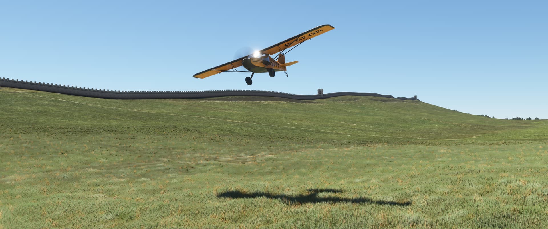
Pee-Wee says: For this final part of our tour, I chose FlyBoy Simulations’ awesome light sport Rans S6S.
It was a bad choice.
Pee-Wee says: Unfortunately, it was. She’s well-built and flies wonderfully—she’s one of my favorite GA aircraft for MSFS—but her takeoff performance is somewhat lacking.
Totally lacking.
Pee-Wee says: I agree that compared to other GA singles, her takeoff performance is more akin to that of a copy machine than an airplane, but we managed without too much drama, although we did clip some bushes on occasion.
And ricocheted off a building.
Pee-Wee says: That’s why we fly with crash detection turned off. ![]()
You hit the Sycamore Gap Tree, for heaven’s sake.
Pee-Wee says: Shouldn’t you be studying?
Next time, let’s take the Zenith.
Pee-Wee says: Immediate action items. Limitations. The AOM Non-Normal Chapter. Go study.
Yes, dear. ![]()
Pee-Wee says: Sheesh. Crash into one national landmark and he never lets you hear the end of it. ![]() Anyway, here are the tour waypoints. We started at Kirkbride Airfield about 10 miles (16 kilometers) west of Carlisle. The runway there is 4,200 feet (1,280 meters) long. If you need a longer runway, you can use Carlisle, although you’ll have to backtrack to the first few waypoints.
Anyway, here are the tour waypoints. We started at Kirkbride Airfield about 10 miles (16 kilometers) west of Carlisle. The runway there is 4,200 feet (1,280 meters) long. If you need a longer runway, you can use Carlisle, although you’ll have to backtrack to the first few waypoints.
| Waypoint | Coordinates | Lat / Long |
|---|---|---|
| Milefortlet 21 | 54.7467 -3.4505 | 544448N0032702W |
| Alauna | 54.7209 -3.4938 | 544315N0032938W |
| Maia | 54.9529 -3.2146 | 545711N0031253W |
| Dixon’s Chimney | 54.8918 -2.9453 | 545331N0025643W |
| Carlisle Cathedral | 54.8948 -2.9385 | 545341N0025618W |
| Carlisle Castle | 54.8972 -2.9420 | 545350N0025631W |
| Petriana | 54.9040 -2.9343 | 545414N0025603W |
| Houghton | 54.9180 -2.9123 | 545505N0025444W |
| Pike Hill Signal Tower | 54.9760 -2.6630 | 545834N0023947W |
| River Irthing Bridge | 54.9913 -2.5920 | 545929N0023531W |
| Milecastle 48 | 54.9890 -2.5735 | 545920N0023425W |
| Gilsland | 54.9913 -2.5724 | 545929N0023421W |
| Turret 40A | 55.0016 -2.4072 | 550006N0022426W |
| Peel Gap Tower | 55.0013 -2.3872 | 550005N0022314W |
| Sycamore Gap Tree | 55.0036 -2.3739 | 550013N0022226W |
| Turrets 37A & B | 55.0108 -2.3496 | 550039N0022059W |
Waypoints in italics require installation of Orbx’s EU Great Britain North. Below are the additional scenery addons you’ll need to see things the way we did.
| Scenery | Author | Payware |
|---|---|---|
| Hadrian’s Wall 180 | Time Machine Designs | Yes |
| EU Great Britain North | Orbx | Yes |
| We Love VFR - Region 1 | PuffinFlight | No |
| Sycamore Gap Tree | Maxest | No |
| Ethnicfs Vegetation Library | ethnicFS | No |
Alright, let’s buckle up and hit the road! ![]()
![]() We Could Just Go Around: Maia and the Western Coast Defenses
We Could Just Go Around: Maia and the Western Coast Defenses
Pee-Wee says: I know what you’re thinking: “What was stopping anyone from going around the wall?” Well, the Romans thought of that, too. To the west of Bowness-on-Solway, they built what we today call the Western Coast Defenses, which looked an awful lot like the original turf Hadrian’s Wall without the actual wall. Wooden and turf “milefortlets” and turrets were built along the Cumbrian coast south to Maryport and may have been connected by a vallum or trench. Very little of the Western Coast Defenses remains intact, although Milefortlet 21 and the old fort Alauna are visible in MSFS. Since the focus of this tour is TMD’s HW180 addon, they’re not included here.
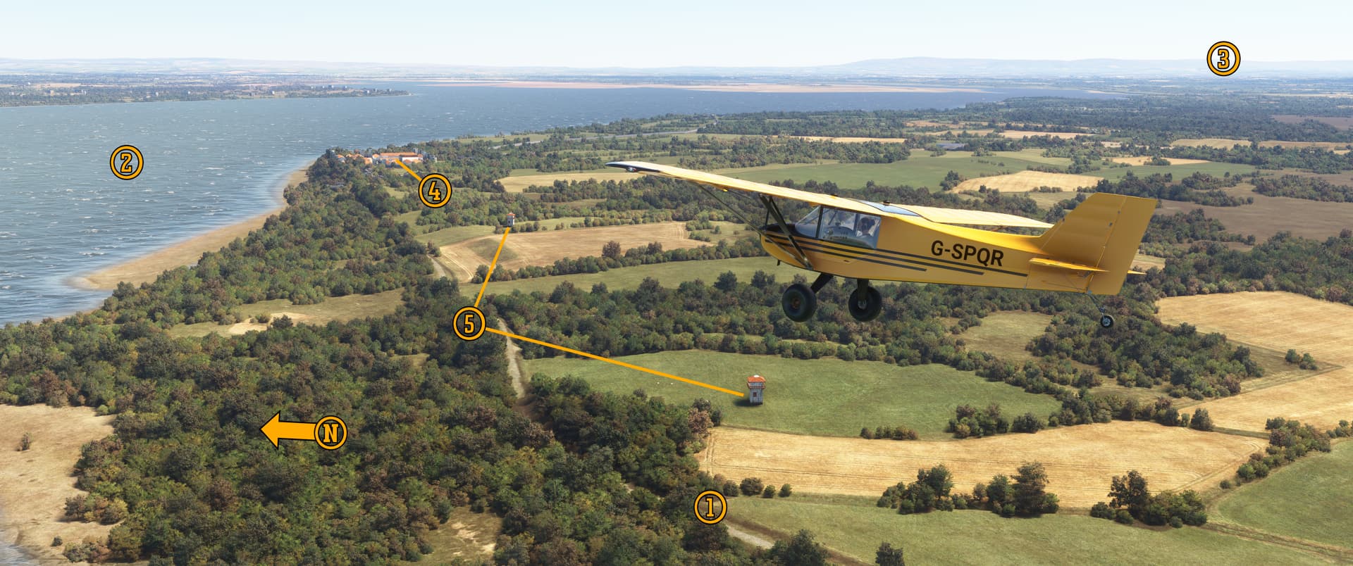
Here we are turning east over (1) National Cycle Network Route 72, a.k.a. “Hadrian’s Cycleway.” The first portion of the NCN was established in 1984 between Bristol and Bath, and today the web of paths and roadways spans 12,739 miles (20,501 kilometers) across the entire United Kingdom.
To the north is the (2) Solway Firth flowing southeastward toward (3) Carlisle. Against the shoreline is (4) Maia, the westernmost and second largest fort on Hadrian’s Wall. While the forts and milecastles use the same 3D building models, the guys at Time Machine Designs used actual diagrams and excavation reports to recreate each individual fort’s, milefort’s, and turret’s layout as it would have been in AD 180.
These (5) two turrets represent those along the Western Coast Defense line, which is not modelled in the HW 180 scenery addon.
Nag’s Study Break #1: The fact that one could so easily bypass Hadrian’s Wall further strengthens the argument that the wall wasn’t a fixed defensive position, but rather a semi-porous dividing line between controlled and uncontrolled areas.
![]() The Opposite of Bliss: Carlisle
The Opposite of Bliss: Carlisle
Pee-Wee says: Here’s Carlisle, or Lugavalium as it was called in AD 72 when the first timber fort was built here. Part of the earlier Stanegate frontier, Lugavalium morphed into the one of the largest settlements along Hadrian’s Wall and was a major supply port on the River Eden.
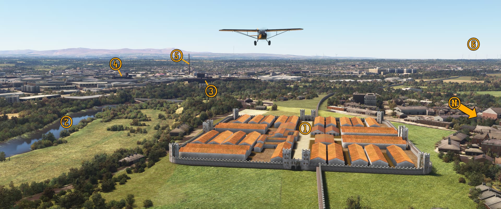
Here we are flying northeast over (1) Petriana. Built in AD 130, the fort was the largest along Hadrian’s Wall. Today this fort lies buried beneath the Carlisle suburb Stanwix (Old English: “stone wall”).
The (2) River Eden was known as Itouna in Roman times, and formed a natural barrier for the fort at Lugavalium, the site of which lies mostly beneath (3) Carlisle Castle. Constructed under William II of England in 1091 and rebuilt by Henry I of England with stone in 1122, Carlisle Castle protected the Anglo-Scottish border for nearly 700 years until shortly after the Jacobite Rising of 1745. Today it’s open to the public and hosts Cumbria’s Museum of Military Life.
In the distance you can see the 900-year-old, Grade I listed (4) Carlisle Cathedral, the 288-foot (90-meter) Grade II listed (5) Dixon’s Chimney, and the (6) windmills at Watchtree Nature Preserve. The cathedral started life as a Norman Priory in 1122 and became a cathedral about ten years later. Today it boasts a wonderful 4-manual, 72-stop, 4,000-pipe organ built by famed designer Henry Willis, a choir that’s been performing since at least 1541 (don’t worry: they’ve stopped for restroom breaks), and a peal of 13-bells that still ring daily. The nearby Dixon’s Chimney dates to 1836. It was once the eighth tallest chimney in the world and served the neighboring Shaddon Mill, the largest cotton mill in England at that time. Today, the mill is an upscale apartment complex and Dixon’s Chimney the city’s most prominent restored landmark.
The Carlisle Castle, Cathedral, and Dixon’s Chimney are all part of Orbx’s EU Great Britain North scenery addon.
Nag’s Study Break #2: Historic or architecturally important buildings and sites in England are “listed,” and may not be demolished or modified without explicit permission. Those of special interest, like the Abbey Road recording studio and Croydon Airport, are listed Grade II, while those of important special interest, like the Brighton Palace Pier and Stoke-on-Trent railway station, are listed Grade II* (pronounced “Grade Two Star”). The most important locations, like the Palace of Westminster and Tower Bridge, are listed Grade I. Of the approximately 380,000 listed buildings in the UK, 2.5% are Grade I and 5.8% are Grade II*. Thousands of houses in England are Grade II listed or higher, and owners must apply for permission to make even minor alterations. Violators may receive a two year prison sentence and an unlimited fine.
A similar system is used in Scotland.
![]() What’s In A Name?: Houghton
What’s In A Name?: Houghton
Pee-Wee says: Many places along the wall’s path draw their names from Roman history, like the villages of Walltown, Walwick and Little Walwick, Heddon-on-the-Wall, Oldwall, and Walbottle. The wall’s eastern terminus is in creatively named Wallsend. All along the wall’s path you’ll find road names like Vallum Road and Hadrian Place in Throckley, Trajan and Antonine Walks in Heddon-on-the-Wall, and Hadrian Court in Humshaugh. In Newcastle there’s West Gate Road which ends curiously close to where Pons Aelius’s west gate would have been.
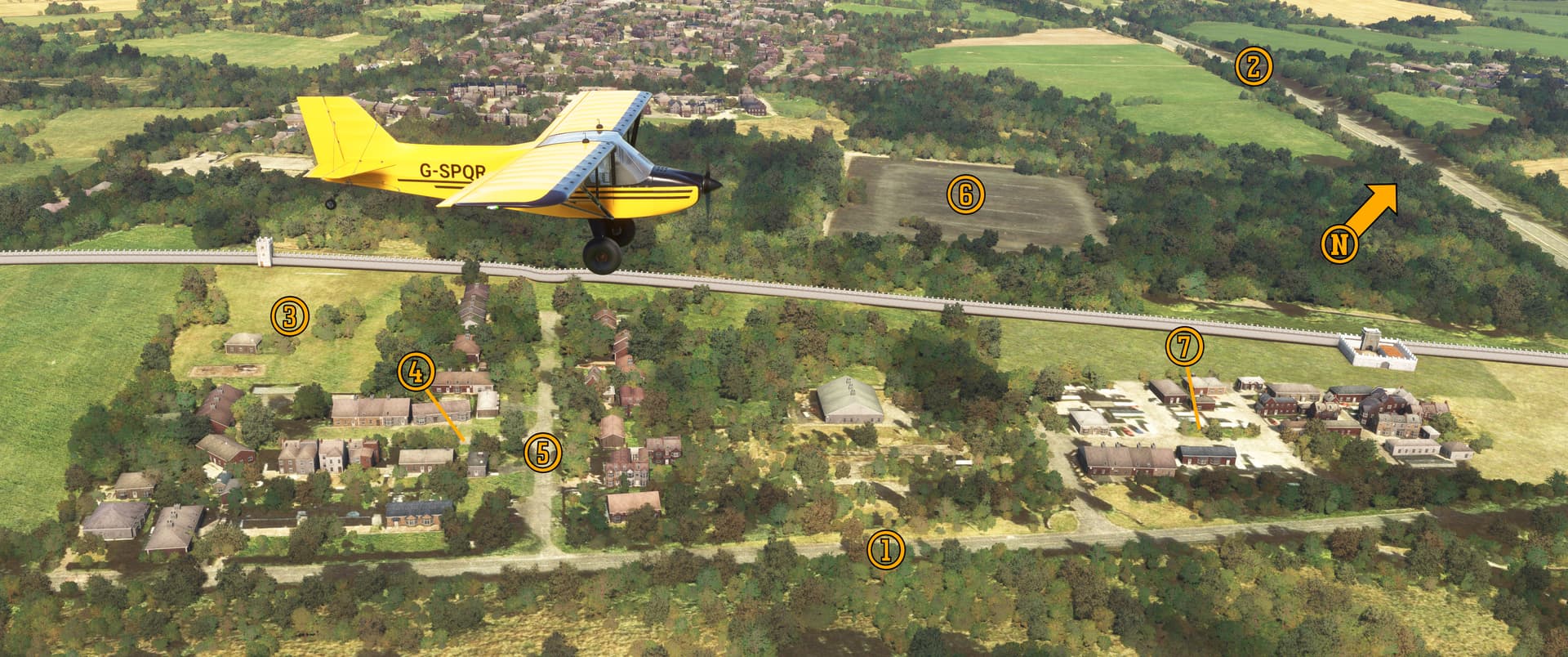
Here we are following (1) Bampton Old Road toward (2) the M6 in the vicinity of Houghton, where you’ll find Hadrian Way, Antonine Way, Tribune Drive, and Eagle Way. (3) This park is named Hadrian’s Park and is reached via (4) Hadrian’s Gardens and (5) Centurions Walk.
For thirty years, the Royal Army operated an artillery, armor, and engineering apprentice school here named Hadrian’s Camp. It was replaced in the 1970s by a (6) police motor pool and (7) Hadrian’s Caravan Park. The park gained notoriety in 2018 when one of its residents, Peter Swailes, Sr., was arrested and charged with violating the Modern Slavery Act of 2015. Inside a wooden shed behind Swailes’s static caravan, police discovered a 58-year-old mentally handicapped man living in squalor, who Swailes had been exploiting for 40 years. (Really? None of the neighbors noticed? ![]() )
)
Unfortunately, Swailes passed away before justice could be served. Thanks to a national charity, the victim now lives freely in a safe house somewhere in England.
![]() Operator, Long Distance Please : Pike Hill Signal Tower
Operator, Long Distance Please : Pike Hill Signal Tower
Pee-Wee says: Approaching MC.57 and the village of Castlesteads, the wall enters hill country and begins climbing steadily toward its highest elevation at Winshields Crags sixteen miles (26 kilometers) to the east. There’s one important point along this stretch of wall that’s not visible from the air: between MC.54 and T.53B lurks the Wem–Bridgemere–Red Rock Fault System. There is a complete absence of limestone west of this line…which is why the wall switched from stone to turf a few miles to the east at MC.49. Ooh! Geology meets engineering! ![]()
Hadrian’s Wall wasn’t Rome’s first frontier across Britannia. The Stanegate (Northumbrian: “stone road”) was a roadway running between modern Newcastle and Carlisle which was built nearly fifty years before Hadrian’s Wall. Several fortifications and towers were built along the road, and some of those were incorporated into Hadrian’s Wall around AD 125, including the signal tower atop Pike Hill. Researchers believe the tower was one of several linking the Stanegate forts.
Pee-Wee says: Here we are flying east past the Pike Hill Signal Tower between MC.52 and T.52A west of the fort at Nether Denton and near the modern village of Banks in Cumbria. Two other towers are located north of the fort at Vindolanda, near the village of Bardon Hill, and researchers believe that others remain to be discovered.
Milecastle 52 (visible between our Rans’s landing gear) is the largest along Hadrian’s Wall, which may indicate a larger garrison to man the Pike Hill Tower.
![]() Where Stone and Turf Meet: River Irthing Crossing
Where Stone and Turf Meet: River Irthing Crossing
Pee-Wee says: Hadrian’s Wall crossed the River Irthing just east of MC.49 where the original stone wall ended and the turf wall began. The first stone arch bridge here was washed away around AD 160 and was replaced by the stone and wooden structure seen in the HW180 scenery addon, which was itself replaced by a wider road bridge some twenty-five years later.
Rivers have a funny way of changing course over time, and the River Irthing today flows through this valley some 220 feet (67 meters) further west than in Roman times, leaving the remains of this ancient bridge high and dry in the sheep-filled paddock beyond. The bridge in HW180 is accurately placed: the guys at TMD moved the River Irthing back to where it was nearly two Milenia ago!
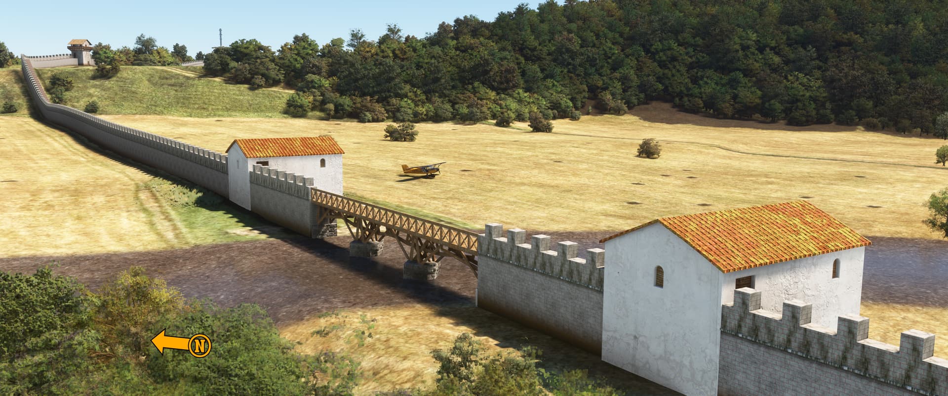
Here we are in the paddock southwest of the Irthing Bridge. Today this spot is known as Willowford, and the Hadrian’s Wall Path crosses just downstream on a modern metal bridge.
Look closely at the wall’s “front face” and you’ll notice red “grout lines.” That’s not a display error! There is some indication that at least some of the wall may have been dressed so and may even have been partially rendered with lime. It’s another nice detail from the guys at TMD. ![]()
Nag’s Study Break #3: Shout out to the troops who rendered 72 miles of wall, and to the Admin Centurions who handled their worker’s compensation claims.
Pee-Wee says: Hey…guess what, everyone?
In the United States, airline pilots must complete “recurrent” classroom and simulator training annually. The month in which a pilot is due for training is their “base” month, but the training may be completed one month early or late in the “grace” months. My base month is July, but I just found out that I’ll be going to training “grace month late” in August, which means…
Pee-Wee says: Which means I get my writing buddy back. Yay! ![]()
![]() A Railway Runs Through It: Gilsland
A Railway Runs Through It: Gilsland
Pee-Wee says: And now I get to talk about trains? Can this day get any better? ![]()
Hold your horses. Let’s talk about this village and the milecastle, first.
Pee-Wee says: Okay, but write fast.
Gilsland lies astride the River Irthing in both Cumbria and Northumberland. The village was, during the 19th Century, four separate hamlets: Gilsland on the Irthing’s west bank in Cumbria, and Rose Hill, Mumpshall, and Crooks on the east in Northumberland. Sometime between 1838 and 1860 the four hamlets merged to become the village we see today.
For decades farming and mining were the largest industries here, but today, nearly one quarter of Gilsland’s population of 400 works in the tourist and hospitality industry. The village boasts at least five large bed and breakfast resorts and other amenities catering to the nearly 400,000 tourists, hikers, and cyclists that pass through here annually.
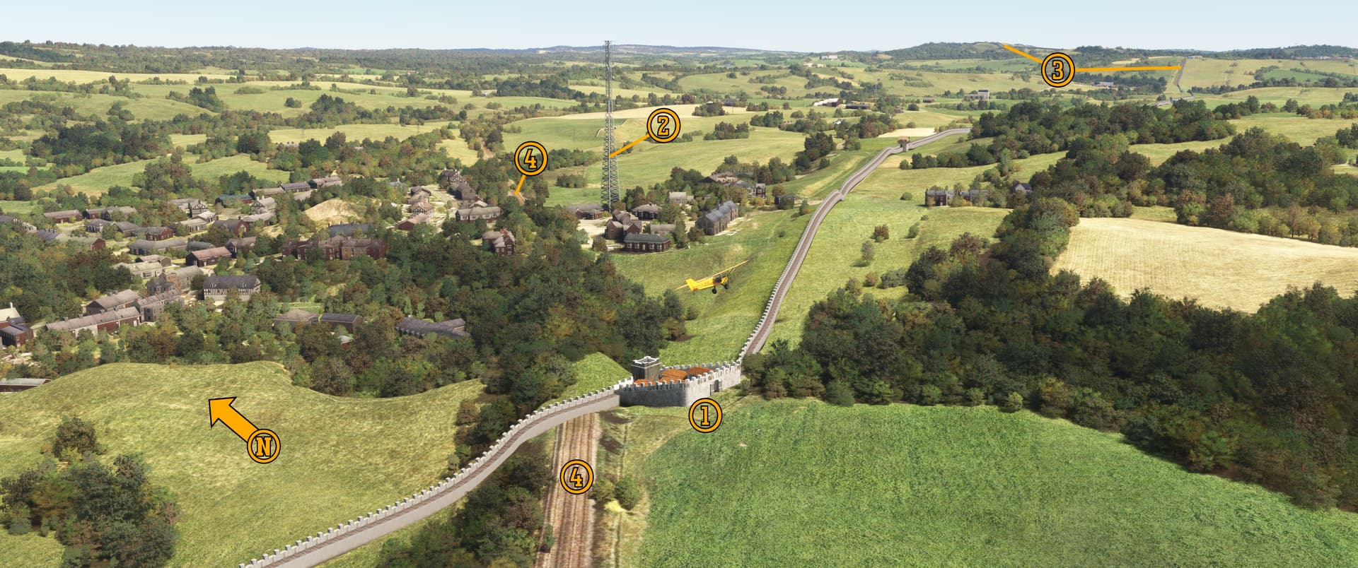
Southwest of the village is (1) MC.48, also known as Poltross Burn Milecastle (after the stream that flows beside it) and the King’s Stables. This milecastle was built on a much steeper slope than any other: look closely and you’ll see that the barracks blocks are terraced.
If you have PuffinFlight’s We Love VFR Region 1 installed, you’ll see this (2) tower rising from the village. It’s not there in real life and not marked on any navigation charts, so watch out! In the distance, Hadrian’s Wall (3) continues east and begins its climb up the Whin Sill near the Stanegate fort Magna.
Regional and local bus operator Go North East’s Hadrian’s Wall Country Bus runs daily from Hexham to Vindolanda, Vercovicium / Housesteads, Cilurnum / Chesters, the Roman Army Museum / Magna at Walltown, and numerous points in between. The service no longer serves Gilsland, but Walltown is only an hour’s walk away via the Hadrian’s Wall Path. The bus is very cleverly numbered AD122.
Okay, you can talk about trains now. I’m going to make us dinner.
Pee-Wee says: Ooh. This day can get better! ![]() In the photo above you’ll notice what appears to be a railway running into the wall. That’s the (4) Carlisle-to-Newcastle Tyne Valley Line, operated by commuter railway Northern Trains. The line sees at least two passenger trains per hour in each direction between Carlise and Hexham, and three per hour eastward to Newcastle. Total travel time end to end is about one hour and forty minutes.
In the photo above you’ll notice what appears to be a railway running into the wall. That’s the (4) Carlisle-to-Newcastle Tyne Valley Line, operated by commuter railway Northern Trains. The line sees at least two passenger trains per hour in each direction between Carlise and Hexham, and three per hour eastward to Newcastle. Total travel time end to end is about one hour and forty minutes.
Northern uses a mix of ageing-but-refurbished Class 156 and Class 158 diesel and diesel-hydraulic multiple unit trains. (For our American friends, think MU’ed diesel railcars.) Freightliner mixed and unit trains hauled by Class 66 diesels make occasional appearances.
Built as the Carlisle and Newcastle Railway between 1834 and 1838, the 58-mile (93-kilometer) double-tracked line changed ownership numerous times and is today owned by national infrastructure provider Network Rail, and will presumably transition to Great British Railways whenever that white elephant is born.
Hey, it might work.
Pee-Wee says: Let’s be honest: the British Government has a way of cobbing things up. ![]() By the way, adorable YouTube train enthusiast and vlogger GLovesTrains posted a video in which she not only rides aboard Northern on the Tyne Valley Line, but also hikes the Hadrian’s Wall Path along the Whin Sill. Go check her out!
By the way, adorable YouTube train enthusiast and vlogger GLovesTrains posted a video in which she not only rides aboard Northern on the Tyne Valley Line, but also hikes the Hadrian’s Wall Path along the Whin Sill. Go check her out!
![]() The Nosebleed Section: Turret 40A
The Nosebleed Section: Turret 40A
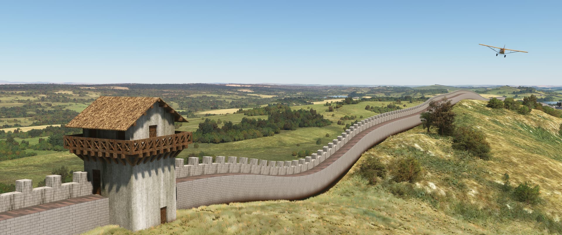
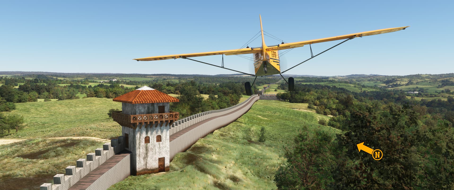
Here we are flying east past Turret 40A atop Winshields Crags. At 1,135 feet (345 meters) above sea level, this is the highest point along Hadrian’s Wall. A stone tower with a veranda and 360-degree views of the beautiful English countryside? Not a bad duty station, if you ask me!
![]() Hadrian’s Blind Spot: Peel Gap Tower
Hadrian’s Blind Spot: Peel Gap Tower
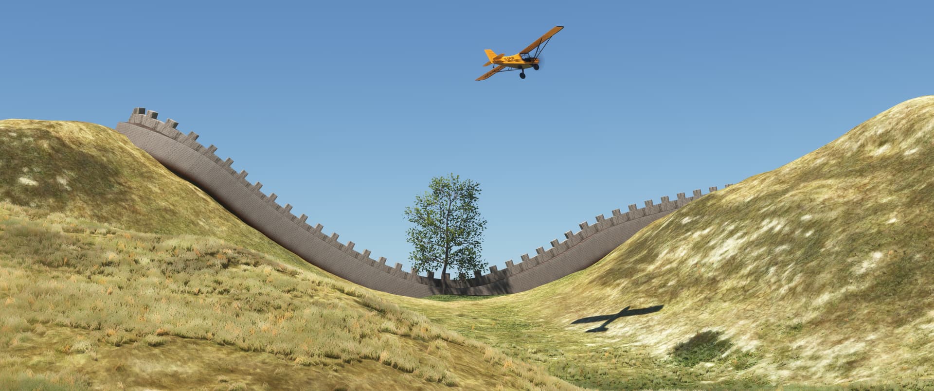
Pee-Wee says: So, you’re flying along the wall, enjoying the scenery, and counting steadily…“milecastle, turret, turret, milecastle, turret, turret, milecastle, turret, turret, turret, mile…whoa…hold up…” ![]()
The Romans were loath to break the pattern of one milecastle and two turrets each mile along the tower but would make adjustments, when necessary, such as at Peel Gap in western Northumberland. Architects and planners realized that, because of the placement of Turrets 39A and 39B, enterprising invaders could approach the wall unobserved through Peel Gap between Winshields and Peel Crags and Hound Hill. Their solution? Add another turret, of course!

Pee-Wee says: (1) Here’s Peel Gap with its extra turret between (2) T.39A atop the Peel Crags and (3) T.39B atop the Winshields Crags. (4) Hound Hill lies beyond. Look carefully and you’ll see the (5) Military Way, which is overlaid by (6) this portion of modern road.
The guys at TMD removed the (7) Peel Cottage which stands just southwest of the Tower. Built in the 1850s and dedicated by the Queen Mother herself, the cottage is managed by the National Trust and accommodates two people and two dogs in 3-acorn comfort. It looks like a great “home base” if you’re exploring the wall, especially since the well regarded Twice Brewed Inn is only a stone’s throw away! But be warned: reservations are hard to come by (the earliest currently available are for November), and each night will cost you about £540 ($737). Jiminy Christmas! ![]()
![]() A Tale of Two ■■■■■■■: The Sycamore Gap Tree
A Tale of Two ■■■■■■■: The Sycamore Gap Tree
You know, I’ll give the forum’s censoring algorithm that one. That wasn’t a very nice word.
Pee-Wee says: Sorry, but this story really gets my goat, and I’m very protective of my goat. ![]()
If you’ve installed Maxest’s scenery, you’ll find the iconic Sycamore Gap Tree approximately one mile east of the Peel Gap turret. This lonely tree became world famous after its brief appearance in Kevin Costner’s 1991 film Robin Hood: Prince of Thieves, and was voted the United Kingdom’s Tree of the Year in 2016.
Pee-Wee says: Lawyer and Newcastle town clerk John Clayton inherited the land upon which the Roman fort Cilurnum stood in 1832, and eventually purchased another four forts and twenty miles (32 kilometers) of land along the wall. A keen antiquarian and archaeologist, Clayton spent fifty years excavating, researching, and preserving the wall’s remains. He planted this non-native Sycamore tree here as a landscape feature sometime between 1832 and 1860.
He we are buzzing the Sycamore Gap Tree in this north facing photo. In Robin Hood, Costner and costar Morgan Freeman climb up the remains of Hadrian’s Wall to the left. (The scene was filmed facing south from the other side of the wall.)
In the early hours of 28 September 2023, the Sycamore Gap Tree was intentionally felled by unknown persons using chain saws. Investigators later arrested thirty-something-year-old friends Adam Carruthers and Dan Graham of Carlisle and charged them each with two counts of Criminal Damage to the tree and wall.
Pee-Wee says: I can’t say enough bad things about these two bellends. Thankfully, they’re as stupid as they look: as word of the vandalism swept the world, the dolts both bragged and sent incriminating photos and videos to each other via their traceable and subpeonable cell phones. As you would expect, the hoodlums turned on each other when presented with nearly unequivocal evidence of their guilt. Both were found guilty in May 2025 and will be sentenced later this month. Each could face up to a decade in prison. (What emoji do I use for “anxiously wringing my hands in anticipation of some idiots’ imminent downfall?”)
Breathe, Honey. ![]()
Thankfully, the tree’s trunk shows signs of life today, and numerous cuttings from the original survive around the United Kingdom. Regardless of the efforts of those two Cumbrian losers, the Sycamore Gap Tree will live on.
Fun fact: Horses are social animals, and keepers often pair goats with lonely racehorses. Separating the unlikely companions usually causes the horse irritation or anger. So, if someone “gets your goat,” they metaphorically take your goat away, leaving you irritated and angry.
![]() Wall on a Wall: The Whin Sill
Wall on a Wall: The Whin Sill
Pee-Wee says: Here we are trimming the grass on the north side of Hadrian’s Wall and the Whin Sill, with Turrets 37A and 37B behind. Milecastle 37 and Vercovicium / Housesteads auxiliary fort are just out of frame to the left.
Hadrian’s Wall generally follows the Stanegate’s course, but the Romans deviated north to the Whin Sill to leverage the towering crags’ great height. Who needs a wall ditch when you can have a 230-foot (70-meter) cliff? And, yes, the forts and milecastles along the sill have doorways opening onto the cliff. Watch that first step!
Pee-Wee says: The Whin Sill was formed roughly 295 million years ago when tectonic movement smashed the ancient continents Euramerica and Gondwana together into the super continent Pangea. During the collision, stretching and thinning of Earth’s crust in northern England allowed the injection of hot magma from deep within the planet between existing layers of sedimentary rock, which cooled and became a dark igneous whinstone known as dolerite. Millennia of erosion slowly removed the surface soil and exposed the towering crags we see today.
English quarrymen used the word “whin” to describe “dark, hard rock” like the dolerite of the Whin Sill. Confusingly, whin is also the Middle English word for thorny, yellow flowering gorse bushes, and appears in place names like Thorpe Whin in East Riding of Yorkshire, Whin Burn in Aberdeenshire, and Whin Fell in Cumbria.
The quarrymen used the word “sill” for flat, horizontal rock formations like the Whin Sill because of their resemblance to stone windowsills. When geologists learned the mechanism by which the Whin Sill was created, they adopted the word “sill” for any sheet-like body of igneous rock formed when magma intrudes between layers of existing rock.
Whin Sill means “dark, hard horizontal rock formation created by magma intrusion.”
Whew! That was a lot of geology, which really isn’t my thing. My head hurts. ![]()
Hmm. That’s ten photos, the forum limit. I suppose we’ll have to continue with an unplanned Part 4! We already have the research and much of the text done, so it should be posted soon. Thanks for tuning in, everyone!
Pee-Wee says: See ya’ soon! ![]()