Pee-Wee and Nag over Northumberland and Cumbria
Hadrian’s Wall, Part 4
We’re into the final stretch, everyone! Here’s the points we’ll visit in this final part of our Hadrian’s Wall tour.
| Waypoint | Coordinates | Lat/Long |
|---|---|---|
| Turret 33B | 55.0294 -2.2791 | 550146N0021645W |
| Cilurnum (Walwick Chesters) | 55.0260 -2.1394 | 550133N0020822W |
| Denton West | 54.9855 -1.6967 | 545908N0014148W |
| Condercum (Benwell) | 54.9768 -1.6643 | 545837N0013952W |
| Wallsend | 54.9857 -1.5273 | 545909N0013138W |
| Rough Castle Fort | 55.9980 -3.855 | 555953N0035120W |
Pee-Wee says: Listos? Vamos a pasar! (Gah! Flashbacks to high school Spanish class! ![]() )
)
![]() Up Close and Personal : Turret 33B
Up Close and Personal : Turret 33B
Pee-Wee says: Let’s take a look at the Hadrian’s Wall frontier from ground level. We landed near T.33B in the space between the vallum and the wall, which was a little rough. (Nag says: Very rough!) You should probably land further away, perhaps south of the vallum.
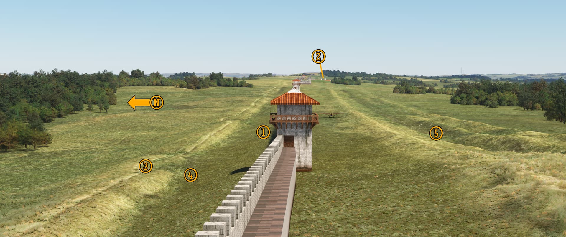
We’re facing east in this photo, looking at (1) T.33B. You can just make out (2) Brocolitia in the distance, approximately three miles away. North of the wall is the (3) spoil mound (with the Hadrian’s Wall Path atop) and the (4) wall ditch. South of the wall you can still clearly discern the vallum’s north and south mounds, and what may be a portion of the (5) marginal mound.
Pee-Wee says: According to the latest press release, TMD’s forthcoming update to HW180 will include not only the vici but some other Roman structures and the vallum.
![]() The Ultimate Landscape Project: Cilurnum (Walwick Chesters)
The Ultimate Landscape Project: Cilurnum (Walwick Chesters)
Cilurnum, known today as Walwick Chesters or simply Chesters, was built in approximately AD 124. The additional entryways on the north wall reveal Cilurnum’s original role as a cavalry fort. Two auxiliary units–the Yugoslavian Cohors I Delmatarum and the German Cohors I Vangionum Milliaria Equitata–are known to have served here.
Pee-Wee says: The Romans rarely adjusted the spacing of the mileforts and turrets, which resulted in some odd configurations: MC.31 is only a few hundred feet from Brocolitia, and T.21A is awfully close to Onnum. Five forts supercede a milecastle or turret completely. When this site was chosen for Cilurnum, the unfinished T.27A already under construction here was demolished and not replaced. Today, only the turret’s clay and cobble foundation remains immediately northeast of Cilurnum’s principia.
Other locations where a fort supercedes a milecastle or turret are: Vercovicium (T.36B), Aesica (MC.43), Camboglanna (T.49A), and Aballava (T.71B).
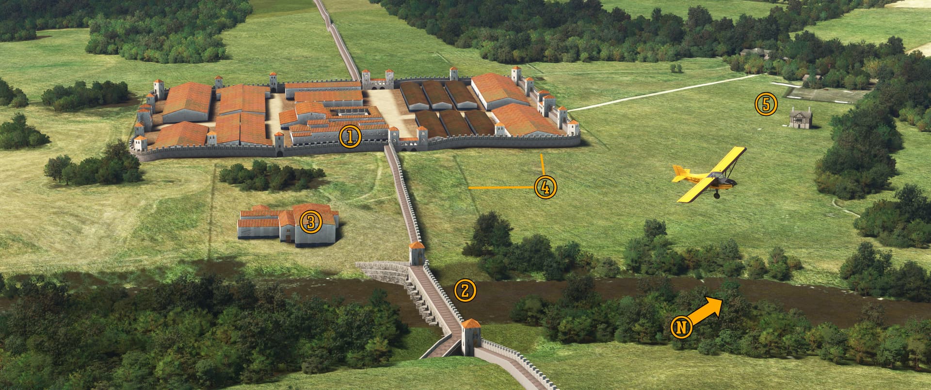
We’re flying northeastward over (1) Cilurnum and the (2) stone bridge across the River North Tyne. A thriving vicus once neighbored this fort, and today it’s (3) bath house is one of the most complete and best preserved in all the Roman Empire.
The guys at TMD removed the Chesters county mansion, once home to antiquarian and famed Hadrian’s Wall protector John Clayton (see Part 3). It was built on the high ground west of the fort almost 1,600 years after the wall’s completion. Clayton excavated large portions of Cilurnum and uncovered hundreds of artifacts, many of which are displayed today at the collocated museum. In MSFS you can see the (4) modern fence which surrounds the site and the Grade II* listed (5) Clayton Museum and access path. (The country house visible near the tree line in MSFS is actually a small shed.)
Pee-Wee says: If you’re in the area, be sure to visit the nearby village of Wall. (Ah, those clever British place names. ![]() ) There you’ll find the Roman Stones Cottage self-catering accommodation and a tour company that provides guided walking tours along the wall.
) There you’ll find the Roman Stones Cottage self-catering accommodation and a tour company that provides guided walking tours along the wall.
Pee-Wee says: British aero engine manufacturer Rolls-Royce named its piston engines for birds of prey (Griffon, Peregrine, Vulture) and its turbines for rivers (Avon, Trent, Spey). The RB.109 Tyne turboprop powered the Vickers Vanguard, Shorts Belfast, and Canadair CL-44, and remains in service today on French Breguet Atlantiques and Turkish Transall C-160s. The RM1 and RM3 maritime versions powered the Royal Navy’s Amazon and Broadsword-class frigates and Sheffield-class destroyers.
Now admit it: you thought the most famous piston engine of all—the Merlin—was named for the wizard.
![]() Ancient History Meets the Commuter Belt: Denton East
Ancient History Meets the Commuter Belt: Denton East
Denton East was a distinct township and civil parish until merging into Newburn and Newcastle-upon-Tyne. Interestingly, Rev. John Wilson’s 1870 Imperial Gazetteer of England and Wales describes Denton East as: “a township in Newburn parish, Northumberland; on the Roman wall, 3½ miles WNW of Newcastle-upon-Tyne.”
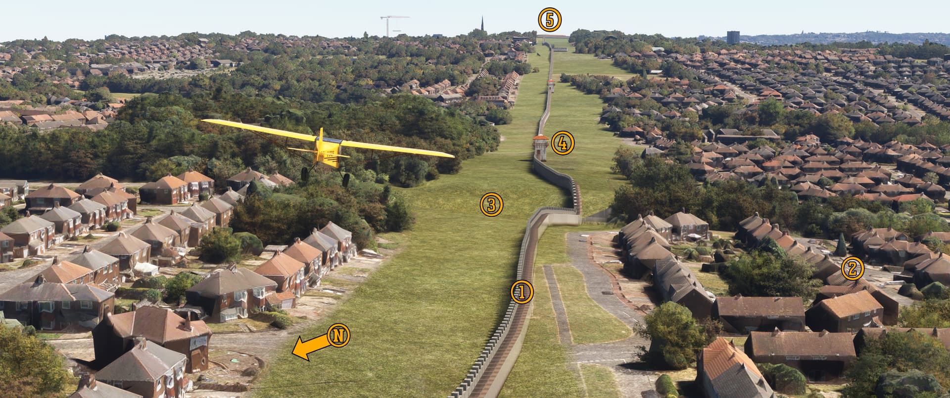
Pee-Wee says: It appears we’ve teleported to Cold War-era Berlin in this photo, but we’re actually flying roughly southeastward over Denton East in the outskirts of Newcastle. The guys at TMD excluded the modern scenery along Hadrian’s Wall, creating a “no man’s land” reminiscent of East Germany’s notorious Berlin Wall.
Want to see Hadrian’s Wall for real but can’t venture out into the country? Newcastle is the place to go! (1) This 75-foot (23-meter) portion of wall is visible today on the southeast corner of the intersection of the A69 and Southway Road outside (2) The Ramparts housing development. When the Ordnance Survey mapped Hadrian’s Wall in 1964, this was the easternmost visible portion of wall.
Across the (3) A1 highway you’ll find (4) Turret 7A. This portion of wall, including the turret’s base, are also visible today along Turret Road.
Pee-Wee says: Turret Road?
Yup.
Pee-Wee says: I’m surprised we haven’t found a road called “Road” yet. ![]()
Hold that thought…
![]() The Home Stretch: Condercum (Benwell)
The Home Stretch: Condercum (Benwell)
Pee-Wee says: Condercum was built by Legio II around AD 124 with assistance from a Roman British Fleet detachment, and was once home to the 1,000-man Cohors I Vangionum Milliaria Equitata, a German auxiliary foot and horse infantry unit.
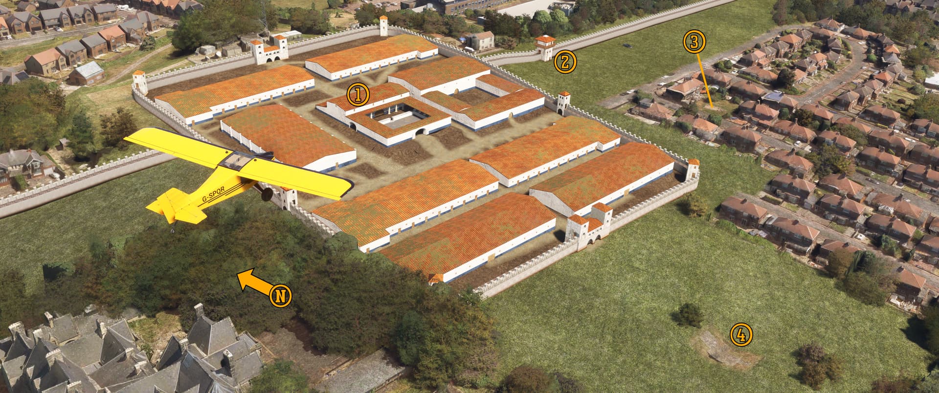
Here we are flying roughly southeast over (1) Condercum. Notice that (2) T.6A is located within spitting distance of the fort’s east wall. Researchers believe that the milecastles and turrets were manned by units separate from those within the forts. I imagine that leaving your little milecastle and walking to your assigned turret through the well-appointed fort with its large barracks, baths, and hospitals was more than a little frustrating. On the other hand, you wouldn’t have shared your milecastle with 1,000 other soldiers!
A substantial vicus rose astride the vallum south of Condercum, and included housing, baths, foundries, shops, and a traveler’s inn.
Archaeologists discovered a (3) temple dedicated to the Roman god Antenociticus nearby. Since Condercum is the only location where his name is mentioned, historians believe that Antenociticus is a local Celtic deity adopted by the Roman troops living here. The temple remains exposed within the modern housing development under which Condercum lies today. The three stone altars here are casts of the originals which were removed in the 1930s, and are currently displayed at the Great North Museum: Hancock in Newcastle.
Pee-Wee says: I looked it up. It’s pronounced…“an-teh-no-SIT-ih-kuhs.”
You can also find the remains of the (4) causeway across the vallum here. Archaeologists agree that this causeway—formerly crowned by an ornate archway and built with smoothly hewn stones—is the “fanciest” remaining along the wall. It’s visible in the modern housing development south of the fort.
Incidentally, if you’re visiting, you’ll find this site west of the intersection of the A186 and the B1305, also known as Condercum Road!
![]() Where the Wall Ends: Wallsend
Where the Wall Ends: Wallsend
As originally planned, Hadrian’s Wall ended at Pons Aelius on the River Tyne’s north bank where the Tyne Bridge and Newcastle Castle stand today. After construction began, a 3.5-mile (5.6-kilomer) eastward extension was added to a new fort at Segedunum.
Today, Segedunum is fully excavated and is the star attraction at North East Museums’s public Segedunum Museum. The museum features multiple exhibits describing the design, construction, and history of Hadrian’s Wall, including replica reconstructions which the guys at TMD referenced while creating the HW180 addon. For a better view of the ancient fort, the River Tyne, and the surrounding city, be sure to visit the museum’s 115-foot (35-meter) tall observation tower. (The museum is visible in MSFS, but the photogrammetry is terrible.) The Segedunum Museum is open daily from 10 a.m. to 5 p.m. (the fort itself closes at 4:30 p.m.).
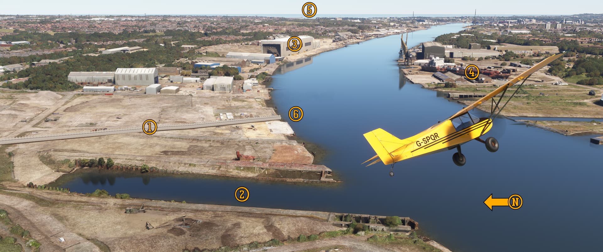
Pee-Wee says: Here we turning east over the River Tyne at the wall’s end at Wallsend. The wall crosses the long abandoned (1) Swan, Hunter & Wigham Richardson Ltd.'s shipyard. The once pride of Cunard Line’s fleet, the beloved steamer RMS Mauretania, was launched (2) here in 1906. Also visible are (3) Smulder’s “Hadrian Yard” where the company builds offshore windmill components and other large steel structures, (4) A&P Group’s ship repair and modification yard, and way off in the distance, (5) Tynemouth where you’ll find a grand collection of lighthouses and the Roman fort Arbeia.
Now I get to geek out about a ship and stuff. ![]() Check this out:
Check this out:
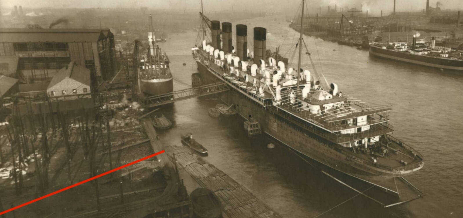
Here’s an undated photo of RMS Mauretania quayside at the Swan, Hunter & Wigham Richardson shipyard. In our screenshot, she’s sitting (6) here. The red line in the real photo shows the location of Hadrian’s Wall. Mauretania was named for the Roman province that once encompassed the northwest African coast from central Algeria to the Strait of Gibraltar. The Roman legion Numerus Maurorum Aurelianorum (“Unit of Aurelian Moors”) was formed in Mauretania and served on Hadrian’s Wall at Aballava northwest of Carlisle. Holy heck, I love historical coincidences!
Cunard Line named many of its pre-war ships for ancient Roman lands, including sisters Mauretania and Lusitania, Aquitania, Andania, Ascania, and Aurania.
I suppose that’s it for this tour. Last call, folks! You don’t have to go home, but you can’t stay here.
Pee-Wee says: Hold on. What about…?
Oh, yeah! Thanks for the reminder. Way back in Part 1 we mentioned that we’d come back to something in Part 3. Well, here we go!
![]() My Wall is Better Than Your Wall: The Antonine Wall and Rough Castle Fort
My Wall is Better Than Your Wall: The Antonine Wall and Rough Castle Fort
Little more than a decade after the completion of Hadrian’s Wall, Emperor Hadrian’s successor, Antoninus Pius, ordered the construction of a new wall further north across Scotland, from Carrident on the Firth of Forth west to Old Kirkpatrick on the Firth of Clyde. Built on stone foundations, the Antonine Wall was a massive earthwork of a much simpler design than Hadrian’s Wall. Between sixteen and nineteen forts and numerous milefortlets protected the new 39-mile (63-kilometer) long frontier.
Pee-Wee says: During the years that Hadrian’s Wall was unoccupied, the fort and milecastle gates were either left open or removed completely so as to not impede the flow of traffic, and additional causeways were built across the vallum.
The Roman Army occupied the Antonine Wall less than two decades before retreating south and reoccupying Hadrian’s Wall. Thanks to nearly two millennia of erosion and construction, very little of the Antonine Wall remains today, although the earthen “Rough Castle Fort” near Bonnybridge in Falkirk is remarkably intact.
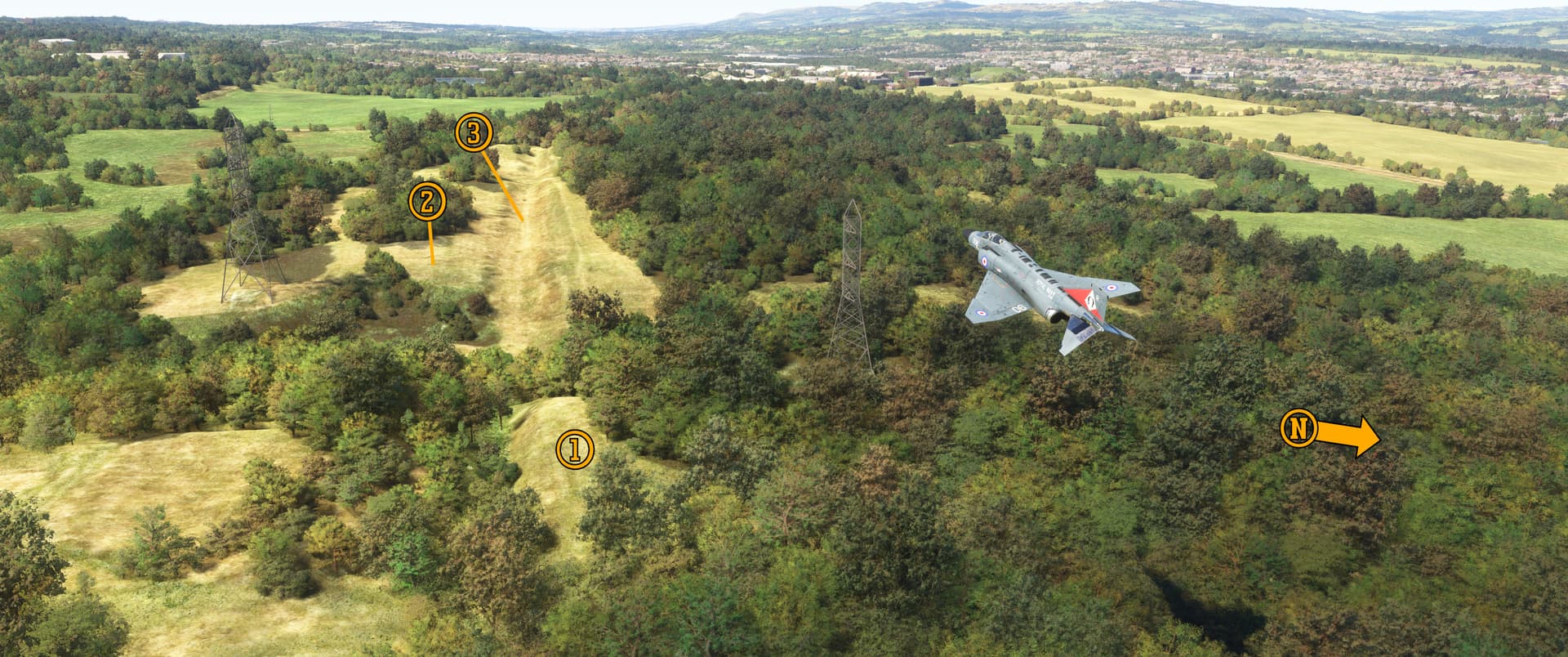
Pee-Wee says: Here we are scorching the treetops at Rough Castle Fort, looking roughly west toward Bonnybridge. You can see the (1) remains of building foundations in the trees here, and portions of the (2) 10-foot (3-meter) tall wall and (3) wall ditch. There seem to be plenty of places to land here but watch out for those power lines!
And now, friends, we’ve really reached the end of our Hadrian’s Wall tour. Who knew that an ancient stone wall could be so interesting?
Pee-Wee says: Writing this tour was far more involved than our previous works. We both learned a ton about Roman and British history, archaeology, structural engineering, the management of ancient construction projects, the Roman Army, geology, sociology, and even marine engineering. Special thanks to forum member @MaverickKing57 who helped keep my motivation up! ![]() And thanks also to Crew Scheduling for letting me have Nag for a few extra weeks!
And thanks also to Crew Scheduling for letting me have Nag for a few extra weeks!
We covered some new intellectual ground, for sure. How rewarding!
Pee-Wee says: It really was! But I’m ready for a break, and maybe something less involved. You know how sometimes you’re in the mood for a movie like Apocalypse Now, 2001: A Space Odyssey, or Silence of the Lambs, and other times you just want a Michael Bay movie? Bring on the explosions. ![]()
About that road you mentioned…
Pee-Wee says: Ooh. Foreshadowing.
Stay tuned for our next tour, everyone, and thanks again for all your support!
Pee-Wee says: Bye for now! ![]()