Hi Literally programming a flight, using Simbrief, programming FMC the route, it’s giving are north west Co ordinates 4939N1000W and 4930N1200W, I understand these are north and west coordinates, but how do I enter these in the FMC?? Apologies if this is a dumb question.
This took me FOREVER to figure this out when i first encountered this in a Flight Plan. It has been a while since I have done one however they can only be put into the FMC via the “LEGS” page.
I believe yours would be written N49W100 and N49W120.
How weird is that, was literally at that waypoint typed into my FMC and worked, I was willing to go into heading mode. You are a scholar and a good person. Much appreciated.
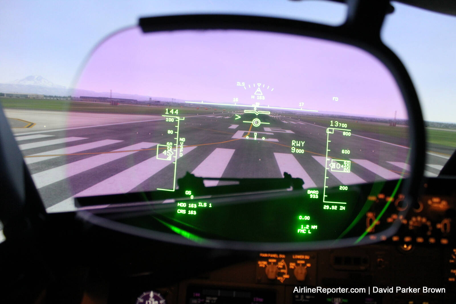
The runway remaining symbology is what the length in used for, as you can see in the pic, “RWY 9000”. Obviously, that’s mostly for reference during low vis takeoffs and landings. PMDG does not replicate this in their HUD which is why it seems odd to enter that information. Presumably, the runway elevation data is one of the parameters used by the HGS to compute its own approach and landing guidance.
I know if the data input for the HUD is incorporated into the FMS, as some 737s have it, that data is auto populated into those fields when a runway is selected. With a separate HUD control panel, like in the PMDG 737, I don’t think that data can auto populate.
A decent hack in the sim world for finding runway elevation is to look at the elevation coded on the Legs page for the runway waypoint, then subtract 50 feet (the box always assumes a 50ft threshold crossing height.). This isn’t always exact and not acceptable in reality, but will get you there in the sim if you don’t want to reference a chart.
The purpose of the elevation entry is for the runway edge lines that are drawn in AIII mode during an approach. I don’t believe the HGS flare guidance references your entered elevation at all, as it’s based on RA. (And yes, the lines are not always well-aligned with the real runway in the PMDG; they often aren’t in reality either but simmers don’t seem willing to accept that for some reason.)
The length entry is used for the runway remaining display, as already posted. This display appears in Primary mode when low-vis takeoff guidance is available, and after landing in AIII mode. PMDG does not model this, so in the sim it’s really just going through the motions to set it.
Also useful is the glideslope reference angle, especially if you’re going to be doing any visual maneuvering or if on an RNP approach with turns in close. The HUD makes the lineup maneuver through the cut to 08 in JNU purely mechanical; just put the thing on the thing.
Very helpful and informative. Kinda surprised that PMDG opted not to replicate these functions, given that this is a study-level sim (whatever that is worth for a commercial entertainment product). Never saw this mentioned before. Now I wonder what other shortcuts or omissions are present? Not aimed as a slag at PMDG, just a general question.
Edit - in your screenshot, I also noted FMC-L in the lower right corner of the HUD. Now you’ve got me wondering if that is present on the PMDG system. Would you happen to know what that reference means?
The FMC L (or R) annunciation is displayed on the NDs in the PMDG 737, just not on the HUD. I’m assuming it’s just a programming choice made by PMDG. It’s a function of the “FMC” switch on the overhead panel. When in “Normal”, the map on the CA’s ND is using data from the left FMC and the map on the FO’s ND is using data from the right FMC.
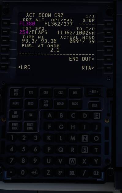
Never saw it, but it’s maybe because you’re over the max. rec. FL with your GW and it’s maybe a hint, that you need flaps to stay there?
Just a thought……
That seems to make sense. GW must have been around 70-71k and CI was 5 so cruise mach must have been ~0.77. It looks like the FMC is asking for flaps to maintain that cruise profile at FL380.
That’s a nice checklist.
Just one thing. If you don’t take off in VNAV you will need to increase the speed on the MCP manually (Bug Up). That happens either at 1000ft AAL on NADP2 departures or at 3000ft on NADP1 departures. After you bug up the you can retract flaps on schedule.
If you do depart with VNAV it’ll bug up automatically at the level you’ve set up in the FMC, which needs to comply with the noise requirements of the airport (NADP2, NADP1 or non-standard noise abatement procedures like for example in Barcelona, London Stansted, etc)
Thank you. You’re obviously at another level of detail from me! I have noticed that if i don’t advance the mcp speed it can get stuck at very low speed in the initial climb, which if you don’t notice immediately can cause a bit of a problem! Didn’t realise that was linked to taking off in vnav though, so that’s really helpful.
In my company we have a callout for that.
On an NADP2 departure, at 1000ft AAL (top of the white band) the PF will say BUG UP and increase the speed bug to the UP speed (If on autopilot) or the PM will do it if the PF is flying manually. Then follow flight director or let the autopilot do it’s thing and retract flaps on schedule.
On NADP1 it’s similar but the BUG UP call happens at 3000ft AAL.
Don’t forget to set your altimeters to STD when you’re cleared to climb to a flight level.
Remember that the autopilot can be used from 400ft AAL after take off until 158ft AGL on approach.
Once “flaps up no lights” you do the after take off checklist.