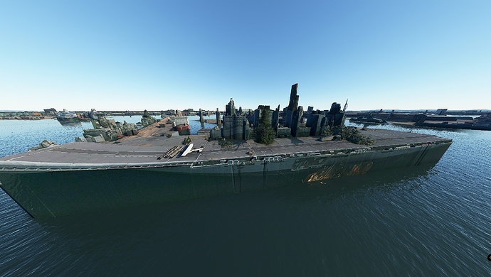
I was quite excited to fly around the Docks looked real nice from a distant that was until i got closer, What a mess cant even ID the carrier although she does have a ramp and love the added trees, when i landed on her the whole carrier looked like it was breathing
sorry for the double post
There’s someone currently working on the Southampton Docks. I am hoping that he’ll continue with the nearby Portsmouth docks, when he’s finished ![]()
I really hope so.
I live in Portsmouth and the photogrametry is great on buildings, even the Spinnaker Tower. I can even see the curtains in my apartment windows using the drone camera!
The docks are a mess though with odd looking blocks where ships should be. One of the problems I guess with 2D satellite photos from Bing, which are pretty indistinct to begin with compared to Google.
haaa would that be me ![]() (Freeware no google imagery) Southampton improvement add-on build 3 out now - #7 by Exemplar87
(Freeware no google imagery) Southampton improvement add-on build 3 out now - #7 by Exemplar87
I am planning to go round to Portsmouth docks next just having a little break from editing as it gets addictive and time consuming.
I will say there isn’t much that I can do to fix the issue with photogrammetry buildings, I know how to fix blob tree’s but that can only be done if its not near any photogrammetry buildings that would get flattened.
Keep up the great work Dorrager.
I can understand that you might have other past-times than getting addicted to scenery development ![]()
Thanks very much for your work!
As far as I’ve seen several people have converted GoogleMaps data to FS2020, but I have no idea how difficult it is.
I also just checked the photogrammetry from Google Maps. Around the docks it looks much better than the stuff in FS2020. The Victory and Warrior are clearly visible (Victory without her top masts though). All buildings have fantastic detail and one of the decommissioned old Invincible class carriers is lying berthed farther north. If it could be done it would be brilliant ![]()
This , thank you for the work
From what I have read from other posts is that it’s illegal to use 3d images from google maps to make scenery for this flight sim and others and then share it with others as the images are copyrighted.
Not sure if there is much that can be done about it though.
In this link in the comments section they recommended the person has a lawyer look at the legal guidelines to help decipher what it means legally.
Isn’t the point that you’re not going to be that close?
yeah that might be a problem of course. Well we’ll see what comes of it. At least no one is trying to make money of it.
