Hi there, I have an question regarding AIRACs…What happens if you don’t update the AIRAC? Can you still legally fly? Pardon my ignorance…Any help is greatly appreciated. TIA
Hm, as a real world pilot yes and no it really depends what your planning to do and on a legal biases I don’t believe so at least for VFR you can possibly fly with an expired database but you wouldn’t be authorized to use it for approaches according to FAA policies.
Thanks for the reply and information…
In the US you can still legally fly. The official FAA policy is “If the database is not current prior to flight, operators should establish procedures that ensure the accuracy of the database for the route to be flown. One acceptable method is to compare the database with the current aeronautical charts to verify navigation information prior to dispatch”. But that doesn’t mean you can do procedures such as RNAV or RNP SID / STARs, RNP Approaches, etc. Those you can’t do with an expired database.
As a side note, not uncommon for some jet operators to spend close to $40,000 per year (per airplane) on database subscriptions. Although smaller aircraft like the CJ are around $7500. Gets expensive. But not updating them isn’t an option.
It’s entirely possible IRL to ask the controller to relay up to date information for you if a chart is up to date. I’ve never heard anyone do this though!
???
Lost me.
ATC relay what?
They’re saying you can ask ATC whether the chart is up-to-date or not, and have them tell you e.g. the fixes and altitudes.
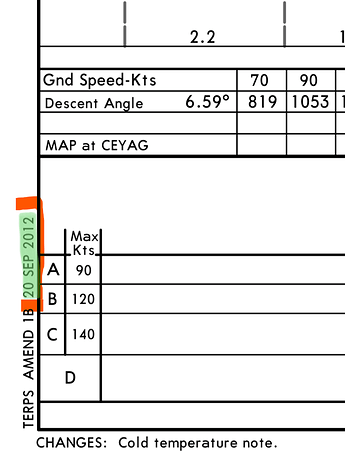
The FAA is trying to make it easier to compare chart changes to nav databases with the implementation of the “Procedure Amendment Date” in the lower left corner of Jepp approach charts (not SID/STARs).
If the nav database is expired, but the expiration date is later than the Procedure Amendment Date on the chart, you are good to go (assuming no P-Notams). Before it would only say “AMMEND 1B” and that didn’t really help too much.
I am sorry.
This makes absolutely no sense.
Part of the pre-flight planning process is confirming that the documentation is ALL in order. I would no more fly with an expired chart/db than an expired medical.
Contacting ATC for DB update info would be the same as contacting ATC to tell them you haven’t done any preparation for the flight.
Yes. I remember having to show the FAA examiner chart expirations for my checkrides.
EDIT: … and in more recent years, I had to show the latest cycle on my EFB app as well as validate database on the airplane as part of “Before Start” checklist procedure.
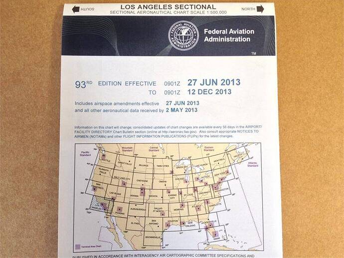
The problem with charts is that they don’t carry an expiration date - only an effectivity date, which is basically “valid until next release”. They are not updated monthly the way that FMS Nav databases are.
A pilot would have to consult the master chart index (which is updated monthly), to insure that a given chart is the latest revision. Pilots also have to consult NOTAMS for any airport they fly to or from to see if there are any temporary changes to already published procedures. This is quite common.
US NOS IFR enroute charts and approach charts do, but Jeppesen enroute and approach charts (which are widely used in professional aviation) carry only an effectivity date. There is no specific expiration date on Jepps.
See @trex5365 's reply.
Also, I take exception to the idea that checking a list of updates to confirm your charts are valid, and consulting NOTAMS along your expected route is a problem. It is your responsibility as a pilot to ensure the safety of your flight.
Is it also a problem to review the aircraft log and ensure there are no outstanding snags?
I do not want to pick on you here Jim but I also don’t want anyone else to get the wrong impression that it is OK to fly with outdated charts or DB regardless of the legal requirements. Being pilot in command of an aircraft means you are responsible for the lives of the people on board your aircraft as well as any you may be crashing into on the ground due to improper flight preparations. Those preparations go well beyond doing a walk around and dipping a broom handle into the fuel tanks.
If we say it is OK to fly with an outdated DB as long as it compares favorably to a valid paper chart then we are saying it is OK to NOT ensure you have done everything in your power to mitigate the dangers to your passengers. In aviation, there are NO shortcuts.
Just a shorthand
As a pilot you know what day it is and you also know what AIRAC cycle is current. If a chart in your hand is more than 30 days old, check for an update.
While in general I of course agree, that is a rather absolute statement.
Scenario: VFR flight in your C172, you have current paper charts and a tablet with updated charts, you navigate with DR and pilotage. On the panel there happens to be an old KMD 550 moving map display that you only use for situational awareness, not for navigation, and an old KLN 94 GPS that you use for Direct-To awareness to your destination airport which most likely hasn’t moved much (and you would know if it did). The GPS and moving map display databases are six months out of date. Oh and that C172 is a rental and it is not even up to you whether it gets updated.
That flight would be legal in any jurisdiction I am familiar with (which admittedly is a small number), and I would argue it is safe. At least as safe as the C152 next on the flightline with no GPS or moving map installed.
Not really relevant. As long as the equipment and paperwork you are using is current then you have done your due diligence.
“Not used for navigation” is the key here. Even before GPS was certified for GA, we have been able to use it in flight for, “situational awareness”, as a supplemental tool. I used my cell based Google Maps. It used to be that electronic flight calculators were not allowed as primary flight planning tools. There are plenty of supplemental tools over the years that pilots have used that were “not approved…”.
There appears to be a serious misunderstanding. I am in no way suggesting that it is OK to fly with either out-of-date charts or outdated FMS nav data. I was just pointing out (for those who may not know) that when it comes to Jeppesen (specifically) - there is no way to know just looking at an approach plate if it is current or not. Individual Jepp procedural plates are not released monthly - revisions to individual charts are released only when they change. This requires checking the effectivity date against the master index. Doing that check absolutely should be part of a pilot’s preflight planning, along with checking any FDC NOTAMS for amendments to existing procedures.
This is literally what I do for a living - as avionics manager for a 6-aircraft corporate flight department, I am responsible for managing all nav data and publications subscriptions, and insuring that current databases are installed in all aircraft, so I am the last person who would suggest that flying with outdated data is acceptable.
NOS charts do indeed carry start and end dates, and those are quite popular among GA pilots due to their lower cost, (for printed chart books) and also among flight simmers since sites like Skyvector or Airnav provide them for free online, as does the FAA. But NOS charts are rarely used in professional aviation.
For those who are using Jepp charts (via Navigraph), I only wanted to make people aware that you cannot tell if a given chart is current just by looking at the effectivity date. At my home airport, KELM, the Jepp chart for the ILS24 approach was effective 31DEC2020, (revision 12-2) and is still valid, because there have been no revisions since then. However the RNAV 24 approach was just updated on October 1st, and carries a revision number of 12-3
Back, before Cell Phone, I use to use a small Portable Garmin GPS for situational awareness. It was not even an Aviation GPS, but one could load all the airports, VORS and NDB into it, and it was a comforting to be able to pinpoint position, and have a record of your flight path, that you could save for later review,

Excellent scenario! The out-of-date avionics should be marked INOP. Since the aircraft is a rental, the aircraft’s next flight may be to an IFR pilot.

