I struggle a bit with my sim role playing where IFR and VFR are concerned. I don’t quite have the right questions to ask so I’m just going to throw some stuff out there and if you have any advice I would appreciate hearing it.
I have passed ground school so I know rules, but I have almost zero experience real world flying- I run into situations that I don’t know if it is realistic or not.
Questions:
How often is a 172 flying around in IFR? Did I make up this rule that ATC will not even accept a plan for under 10k ft?
How do I measure VFR minimums when looking out my window? I’m not even sure exactly how far the cloud is in front of me, how high or tall it is, or how much space it is from the next one. Or do people just not VFR with much cloud?
I think I need to start weather planning a bit more so I can be prepared when the sim launches. Where is a good spot for a beginner to find cloud layer info that will relate to live weather?
For you low and slow pilots- what do you tell yourself when you load up the sim and unexpectedly it is IFR conditions? Just file a plan and go? Change weather? Assume that the ATC and minimums never existed and just go about your flight?
Specifically I am looking at the cloud base and tops so I can plan altitudes and routes accordingly. Also looking at weather, icing, etc…
The 172 is fully equipped (both Steam and G1000 variants) to fly IFR and as far as I am aware, there is no altitude restriction on an IFR plan (meaning you can’t fly below 10,000). That said, there is a speed restriction below 10,000 (which is 250KTS, and not a concern in a 172).
There are also altitude designations based on your heading, and if you are IFR or VFR.
When flying a magnetic course between 0 and 179 degrees, you would fly IFR at odd thousands and VFR at odd thousands plus 500.
EX:
Heading 145 IFR altitude would be 7,000 feet while VFR would be 7,500
And as you could guess, heading 180 to 359 is flown at even thousands for IFR and even thousands plus 500 for VFR
EX: Heading 228 IFR altitude would be 8,000 feet while VFR would be 8,500
For your VFR rules, again you’d look at a site like Meteoblue to determine weather, clouds and icing. and plan your route accordingly. There are also VFR rules (minimums).
I am not a pilot and this is just what I have learned since starting in the sim (as best as I understand it). Someone may have some corrections.
If conditions and routing were right you can fly VFR right up to the 17,500 limit. A new M600 owner did that and he was only VFR qualified, flew it all the way from TX to FL. Would have gotten away with it too except he got a cross-wind landing which he hadn’t fully trained for and ended up wrecking a brand new turboprop.
And that’s the beauty of the sim; ATC and traffic aren’t at a stage yet where there are RL consequences for breaking obvious pilotage, navigation and safe operation rules.
For those wanting a closer RL experience in VFR, request Flight Following. At the minimum, you’ll be prompted (at least if you keep the ATC window open) for Airspace transition, as well as receive traffic advisories. You’ll also get a sense of environment and immersion by listening to AI ATC and AI Traffic interact over the active frequency.
Once Working Title revamps ATC, things should get a lot more stringent (or that’s the hope anyway) because ATC engine will understand how to deal with all AIRAC leg and procedure types. What would even be better is somehow to enable AI collision. But that has some legalese and reputational risk around it, so that may never be in the cards. Not to mention AI traffic behavior needs a revamp too, otherwise you’d have collisions all over the place just on slow runway exits and no adherence to Missed Approach Procedures.
As long as the aircraft is certificated to fly IFR, it can fly IFR all day. Plenty of GA pilots do it. There is no such rule about flight plans under 10000 feet.
I assume you mean looking out the window from your aircraft and not from your house. If you’re on the ground, there are tools.
In the air, you have advanced avionics that can give you things like radar (precipitation) and METARs. I am not an avionics expert, but I don’t know of anything that will depict clouds. (Maybe someone can fill that in.) In ground school, they also drill into your head that unless you have an onboard radar (hint: your 172 does not), any weather you get on your avionics is 10-15 minutes delayed. So if the weather is changing rapidly, you do not want to make decisions that could get you killed or your license revoked based on delayed onboard weather.
In real life (and if you’ve passed ground school, it sounds like you want to do this in real life), if the distance to the next cloud is a concern for you, then you’re probably in a situation where you either need to descend to a lower altitude or get on the ground immediately. Dodging clouds as a VFR pilot is called scud running and has caused many pilots to experience a CFIT, or controlled flight into terrain.
I don’t know where in the world you’re located, but if you passed ground school, I’m very surprised that this was not part of your curriculum. If I were in your situation, I would look up the aviation standards in your country (in the United States, it’s called the ACS) and ensure that there wasn’t something in your curriculum that got missed by your instructor(s).
In the United States, your official weather sources are places like aviationweather.gov, Leidos Flight Service, and EFBs like ForeFlight and Garmin Pilot. You can use your TV news broadcast to make a “no go” decision, but official sources must be used as part of a “go” decision. On both of those websites, you can do things like look at the METARs along your route and see what’s VFR and MVFR (marginal VFR). You can and should also check forecasts. But weather, in general, is a huge topic. And if you haven’t spent a lot of time with it, here is a YouTube video on weather theory and practice that I watched several years ago that is really good. And here is a Sporty’s webinar that I haven’t watched, but I love their webinars and that video probably has a lot of good stuff in it.
What do I do in the sim? I mostly fly VFR with live weather. If I spawn some place I want to fly and the weather is bad, I usually just go somewhere else. I do fly according to Visual Flight Rules almost all the time. The only time I don’t is when the weather changes abruptly and a cloud just materializes in front of me in 10 seconds. Then I just sigh and plow through it. Ideally, I’d love to use real-world planning tools to do my journeys, but I don’t think the sim is there, yet.
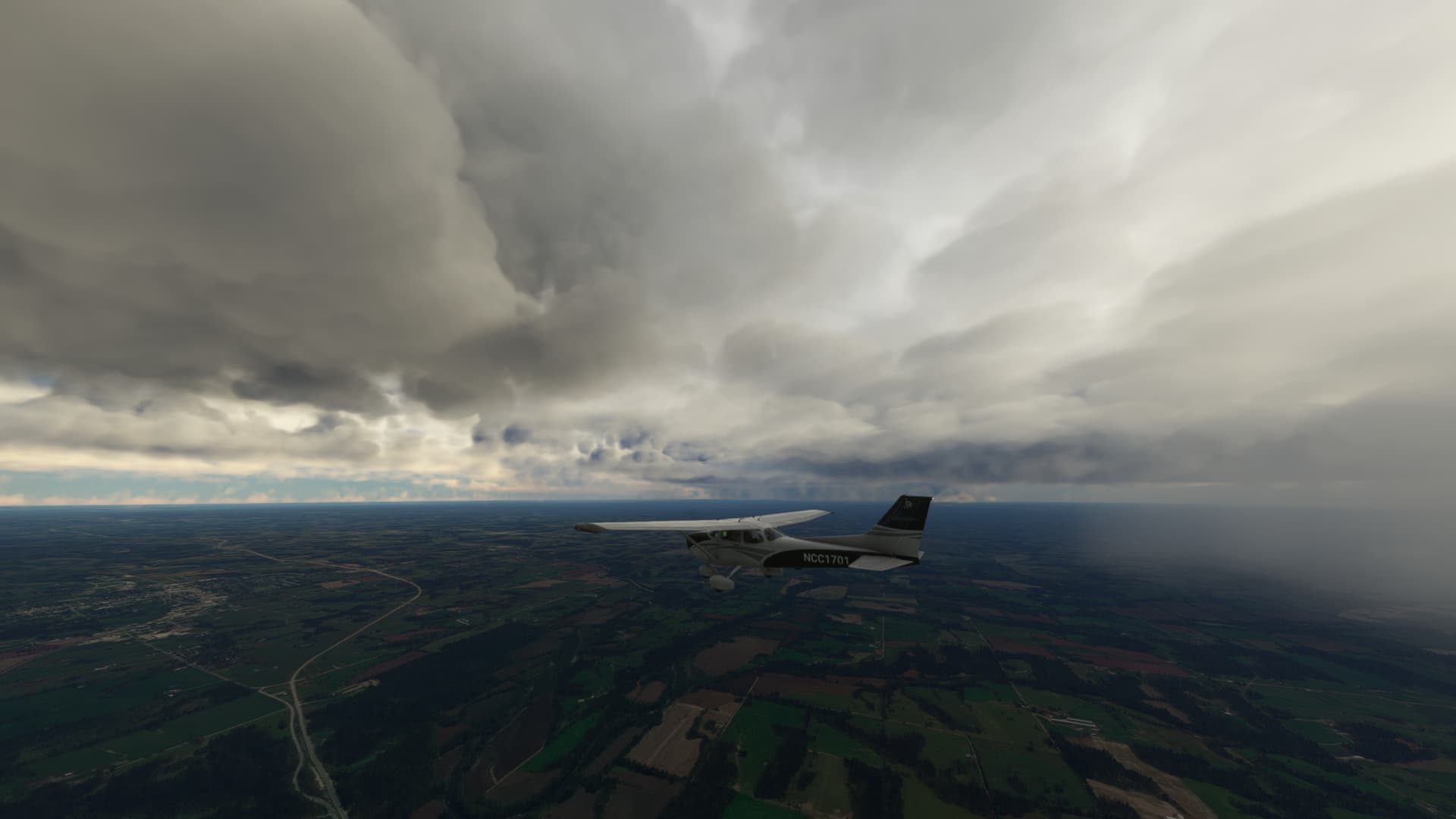
I appreciate your thoughts! Your great pics of the 172 flying in/near weather is what finally prompted me to ask these questions.
Yup, greatly looking forward to more depth and accuracy with in game ATC! On one hand I’m enjoying learning without the added work load, but I also know I’m missing realism/immersion.
My ground school was at a US community college (pre YouTube, thanks for the links!), followed the textbooks word for word and had plenty of weather introduction. Unfortunately years have passed and flight sims are extremely forgiving for inexperience so weather is something I never felt like mastering.
I’m now thinking my questions arise from a lack of RL experience, lack of consequences, and self paced discovery. The combination of the above is leaving me uneasy sometimes… I don’t know what I don’t know.
I’m in a different camp about the live weather. I would love even rudimentary weather planning in game. Even a simple indicator of I, V, or MV would get me up in the air happy most of the time, but base cloud layer, visibility, and wind speed at cruise level and ground would be a dream.
Anyhow, thanks again for the time, much appreciated!
Ahh, okay, so you went to a part 141 flight school, then. (And I used the term “ACS”, but it would have been called the PTS back then.)
If you want to get back into the swing of things, there are several flight schools that have a ton of videos online. We’re not supposed to talk about real-life aviation here too much, but because this is about applying this information to MSFS, I think it’s okay. In a previous post, I gave a list of some YouTube channels that are excellent resources. Another ground school has a playlist that you can just sit and watch. (I think that that instructor is very arrogant, but he knows his stuff.) Or you could go down to your local flight school and tell them you’re a rusty pilot and they’ll set you up with a few hours of instruction. But, I don’t want to go too far down this conversation because we aren’t supposed to talk about real-life aviation here.
Don’t get me wrong. I would like in-sim weather tools, too. In fact, I was saddened that when they introduced in-sim METARs, they didn’t make them available from the World Map when you’re planning your flight. But I would also like a weather system that would be close enough to real-life that I could use real flight planning tools. Let’s hope we have them both some day!
I think a limitation example for US IFR flight plans would be altitudes filed above MVA - Minimum vectoring altitude. That’s to avoid smashing into stuff.
Take a look at the World Map weather information available by accessing the FILTERS. The top three show satellite, IFR, or blend. The next one shows clouds, precipitation, or none. The third one shows WIND direction and speed for airports at the ground, low, and high altitudes. I don’t think IFR is shown correctly. Make sure your Live Weather feed is enabled and allow some time for the info download and display prep. It is very rudimentary…