Has anyone successfully landed using RNAV with vertical guidance using the G1000? I am itching to press the VNV key and press it again if TOD is greater than 5 minutes.
If you have successfully done an RNAV landing with automatic altitude adjustments, can you provide some guidance? Which airports, which plane, what procedure? I am kinda hoping this works on the Cessna but I can try it on any plane.
Not yet. I have gotten a lot of glidescopes to work. But many approaches have either the wrong fix for the beginning of the glide scope. Or the wrong altitude for the glide scope. But rnav for arrivals doesn’t seem to work. Incomplete g1000, g3000, and fms and what seems to be some altogether wrong route data according to real world charts.
Yes, the RNAV LNAV / VNAV is working for me in the 172 with G1000. Just flew into KGPT at minimums and shot the RNAV RWY 14 approach. You should fly to the IAF first and engage the Approach in the AP. You have to get established on the approach. Slow to approach speed around 90-95 knots, and it will fly you to the runway. I’ve tried this at several airports and it works fine.
Ehhhh, I would be cautious to say just fine. Yes, it works if you use if you follow the way the sim wants you to but, it is not realistic at all.
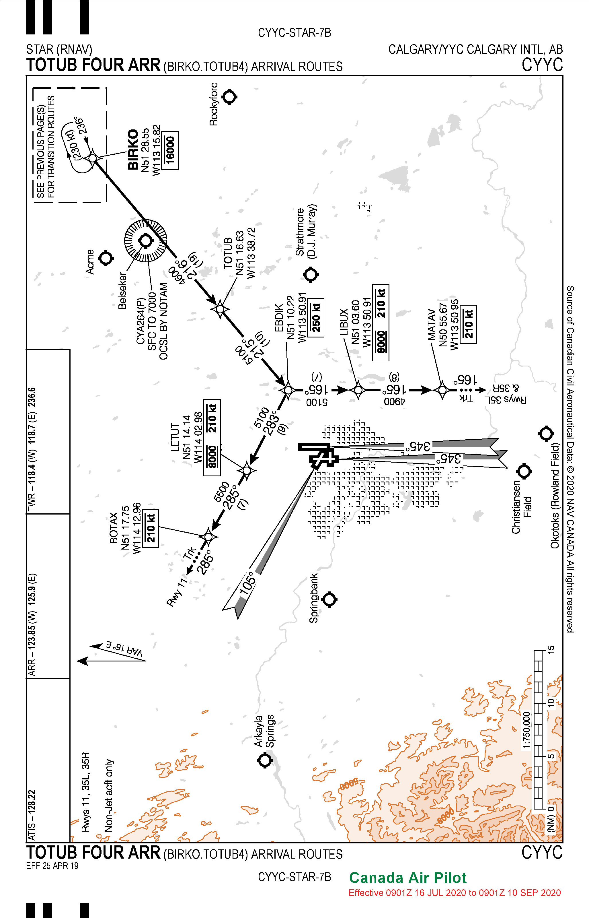
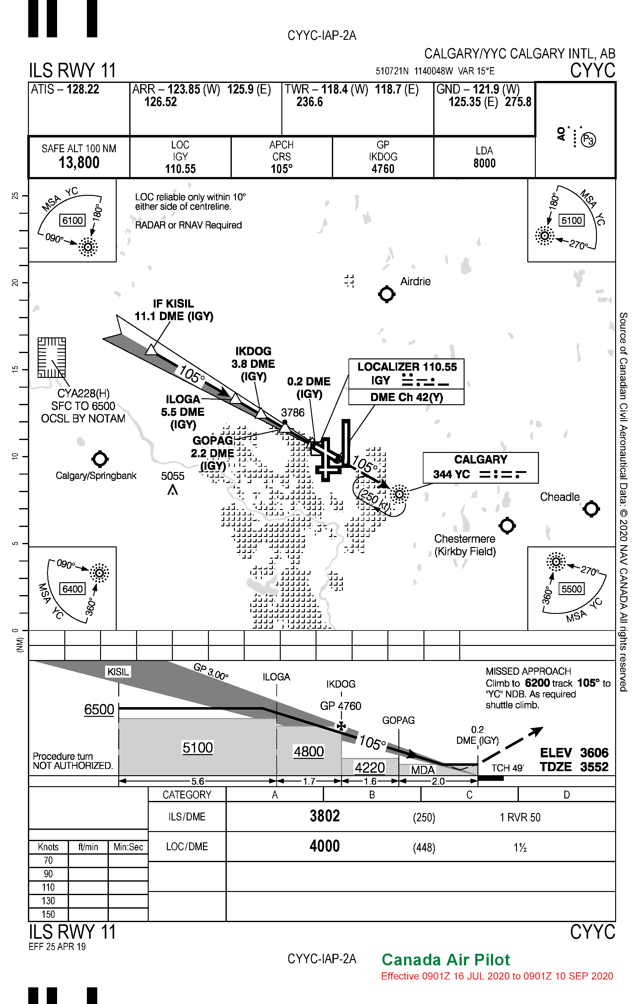
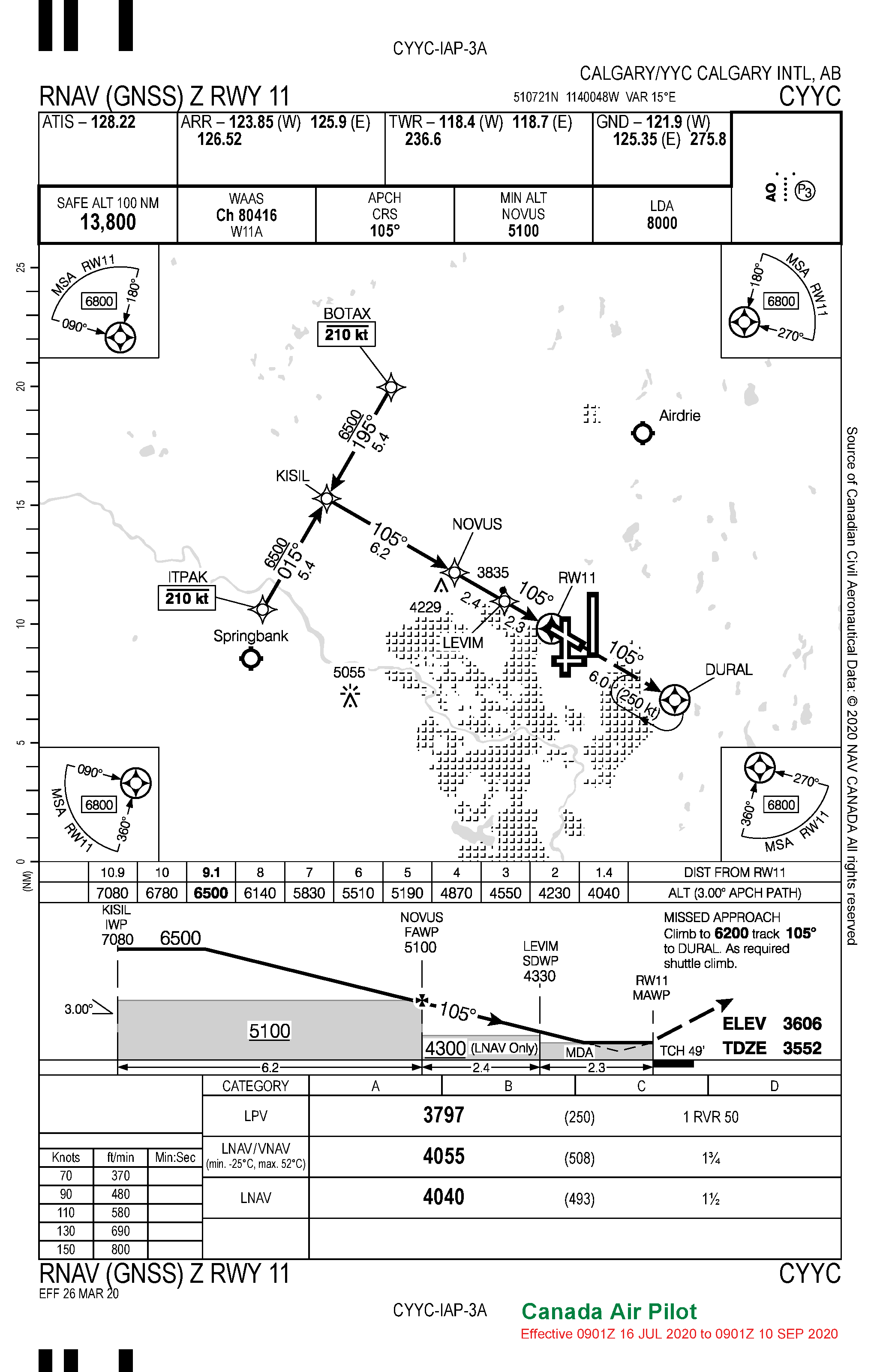
In your specific example the TOTUB 4 STAR is an open star, meaning it has no link to the approach. After LETUT there is another waypoint, BOTAX and after that an open vector to infinity. ATC should either give you vectors onto the approach or a clear you onto the approach through a IAF that is common waypoint with the star. Which for the ILS 11 in YYC is not possible as there is no common waypoint on the STAR and the approach. I’ve included the RNAV Z RWY 11 as an example of an approach with a common waypoint, BOTAX.
The sim blatantly disregards BOTAX and links up the approach with this weird arc to KISIL. In reality it should be depicted and flown exactly as on the arrival chart. ATC should have provided you a vector to the ILS. Once you’re on the ILS, looks perfect.
First off congrats on successfully flying an RNAV approach from the IAF, secondly I have a few questions.
Is the sim letting you direct to the IAF? What altitude are you intercepting the glide path at? Do you get a glide path indication on the PFD?
I have only managed to get vertical guidance inside the FAF. I will descend to the FAF crossing altitude which is also the minimum safe altitude for the previous segment of the approach with the GP armed and will capture and fly down to minimums once passing the FAF. Do you happen to have any screenshots of your endeavour?
Thanks for the reply, yes you are correct, but I am speaking about ILS as a landing system is fine, not MS’s implementation of the navaids and SID STARs etc.. or ATC for that matter, that clearly needs some work.
I outlined this in the above video and the complementary video (although not specifically) as a point thats bugging me as I can’t plan something in NAVIGRAPH and depend on its import into MS without losing the proper STAR and MS just deletes it and links it direct to the approach.
Yup, ILS works great. RNAV, all the same problems as discussed above.
Watched your video as well and noticed on the VOGIG departure the G3000 simply continues on course after the departure instead of continuing straight out as its a open departure procedure as well. Must be stopgap because direct to isn’t working correctly?
Tough go importing flight plans from Navigraph hey? It might be because the flightplan you’ve created is actually correct and accurate. The sim doesn’t know what to do with it! haha
Wonderful to see a fellow Canadian posting videos, great work!
to be more specific, the context of my “it’s fine” is that I have landed using ILS. Additional context is the OP asking if anyone has landed using the system.
In general I’m having many problems with the navigational charts built into MS compared to actual charts.
My biggest beef however is with the taxi ways being different than real life. Taxi via A B C in real life those same taxi ways are C F Z. Makes it impossible to use real charts to figure out where to go, and the taxi signs in the sim are too small and hard to read at 30 fps for me to see them. sigh. Hoping this gets. fixed.
I really hope they get the sim to accurately reflect the proper procedures regarding charts. I’d prefer these changes over the usual squabbles about flight characteristics or models.
I honestly spend as much time trying to wrangle the flight plan in MS to closely match my plan in navigraph as I do flying sometimes.
And then just when you start getting it close, something changes and it autoroutes your Victor lanes again on you.
they really need an add before or add after etc… or even let you manually type the route. Anyways, just rambling on…
From Greater Toronto Area myself, but have been all over the country.
About to fly my next leg from Calgary to Vancouver through the mountains. Looking forward to this one, but this is one of the more important flights for me and I’m going to fly it unfiled, but I spent a bunch of time planning it in navigraph to hit a bunch of points of interest on the way over (banff and a few others) and am scared I’ll get halfway there and not be able to tune or find a VOR or navaid. we’ll see.
A bit lengthy on the replies, but yeah, I don’t know what happend with the departures.
Was supposed to be a VISUN 1 departure from my navigraph plan, but at this point I was kind of giving up (almost an hour) trying to wrangle the proper FP with MS, so i just did whatever it had in it, but flew my VISUN chart until told otherwise by ATC, lol.
I apologize if my previous comments came across target at you personally, its at the sim itself. Taxiways being mislabeled and with very small signs are a huge gripe for me to. Makes it impossible to taxi referencing a taxi chart. I hope they fix IFR flying and the taxiways before anything else as well. There is more than enough planes and the flight model is good enough for now, especially on GA aircraft. IFR flight planning is on that list too, its not great at all.
Best of luck with your future flight! I fly all the time from Calgary and Edmonton into various destinations into BC and the views are absolutely spectacular. Enjoy!
No worries, not at all. Nice to see a fellow Canuck.
Can’t wait for the mountains, flown a similar route in real life a half dozen times and only once had a half decent view of the mountains. One of the benefits of choosing your weather.
I have done it successfully with vertical guidance past the FAF. Prior to that its hopeless, always full down the deviation indicator on the PFD. I descend to the lowest safe altitude prior to the FAF and arm the GS by pressing the APPR button. Should intercept when you cross the FAF and guide you down.
The devs have noted that VNAV isn’t implemented in GA aircraft at all, only the airliners and even that is pretty terrible. Hopefully it gets fixed soon and hopefully my tidbits are useful. Let us know how it goes!
I’m not a pilot but all i do know after using the TBM is that it lines up with the runway following a LOC but does not start descending down until i press VNV. It just lines up and goes straight. I’m no expert :).
Sounds like you need to tune your ILS on NAV1/LOC1 and then switch to that on your HSI when approaching the ILS and then hit APR. The VNAV button is uneeded to follow the glide slope and is used to follow the vertical references in your flight (nav) plan. If you don’t arm your approach or just hit nav on your LOC1, it will just follow along to the airport without trapping the glide slope.
Keep in mind also, that an airport may have an ILS localizer without a glide slope which will keep you centered on the runway much like gps, but will not have the landing system or glide slope.