RNAV GNSS Approaches?

I am looking at this chart and I don’t know how to find out whether the approach has vertical assistance or not. Usually I look for a term like LNAV/VNAV but this chart just says RNAV (GNSS).

Can anyone see anything suggesting whether it has vertical assistance ?

LNAV and VNAV assistance comes from the FMC. When you create the flight plan, you insert nav point writing them and inserting their respective altitud, and that is what gives you guidance. When you have to land, or takeoff, you use these charts and you have to select the approach from the FMC database. The plane will follow the vertical and lateral path, but don’t expect it to autoland.
In case you need more assistance to land, you can choose to fly an ILS approach.

This approach ends 3000 ft above the airfield in the vicinity of the aerodrome for you to perform a visual approach (or missed approach if no runway in sight). I believe this is a LNAV approach which is a non-precision approach since it ends in a circling MDA, you can always use advisory VNAV of course. Whatever the guidance, you need to perform a circle to land from minima, like a figure eight in the valley in order to line-up and land. When you are visual early you might be able to visually follow the valley and descent lower for a straight-in?

This is a misleading depiction cause it looks like you are coming in straight-in, this is not the case, neither vertically, nor laterally (see MDA = 2900 ft above the field).

image

3 Likes

Why would you add every point manually if you can just select the approach? In real life it isn’t even allowed to change the approach procedure manually, including altitudes. There is no ILS there obviously, there is a reason why this approach is the way it is.

1 Like

This is a game, not real life, so what you or they do in real life I don’t care.

Taking a step back to cool off

@anon50268670 is a flight instructor.

The original question was “is this approach coupled?How do i fly this?”

He tried to respond correctly and educate that it is not allowed to modify approaches.

You can manually construct if you’d like, but that wont be doing it correctly (and is illegal… and in this instance may cause catastrophic hull loss and severe injury), which i believe the original intent of the question.

For example, a manual construction may not trigger the GNSS / RAIM monitoring to reduce tolerance to approach category. Seeing as there is hazardous terrain, i’d very much want to correct GPS tolerances.

2 Likes

RNAV (Area Navigation) approaches are based on GPS waypoints; there is no ground equipment such as you would find with an ILS. If the GPS navigation unit in the aircraft is sophisticated enough, it will be able to provide vertical assistance and you can use it regardless. In fact, the “dive and drive” method of approaches (descending in steps) that was taught back when I was flying is no longer recommended and descending with a constant glide path angle is preferred. That said, some RNAV approaches are certified for different minimums depending on whether the aircraft is equipped with LNAV, LNAV with VNAV or WASS (wide area augmentation system). The latter is extremely expensive IRL and is probably only currently available in MSFS if you are equipped with a GTN750Xi or flying the PMDG 737. In any case, if an RNAV approach is certified for anything beyond LNAV, you will see separate minimums for the additional equipment certifications; i.e. LNAV, LNAV/VNAV and/or LPV. If you have the required equipment, you can use the lower minimum. The shown approach is only certified for LNAV, which makes sense as it is a circling approach and not assigned to a specific runway.

4 Likes

I recommend take C172 G1000 and set this app to Garmin. Activate app and you will see. Due airport max allowed aircrraft category/rwy length/circling restrictions you can try higher spec aircraft then. This app is very similar to LOWI app for to get aircraft with circling app to oposite rwy. It guide you stay safe within terrain to vicinity of airport. I expect C172 will follow also vertical path with correct FMC set as indication on primary nav.

This was my flight to this airport on the same RNAV approach that I’ve done a year ago.
I manually use the TRK/FPA mode in my A320 to start the descent according to the angle in the chart. Although I didn’t do the circle to land maneuvre at the time and I just went straight for the runway as soon as I have visual.

Generally,

you can use what you want with descent control, important is not go lower as chart shows with each part of track. Correct set of altimeter pressure is simply required because then in other case big hazard.

Well, maybe not – have you tried “DELETING” WPs from a loaded approach !!!

Game or no game, MSFS it wont let you – (which is GOOD !!)

1 Like

It would seem that teh standard Asobo code (based on the old 10+ year old FSX code), is not able to identify which Fix on an Approach is the FAF.

It seems to “Assumes” it is the last one before the runway.

In some cases, this may be true, in others it is not.

So if your selected Rnav approach has waypoints after the FAF, current Asobo Code will not switch from GS-Arm to GS at the FAF, but will wait to try to do this at the last WP before the runway !!

image

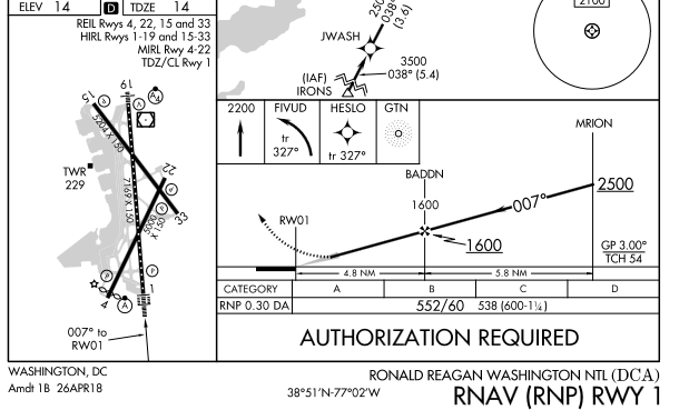
FAF BADDON, last fix on Approach, will switch from Arm to Active at BADDN if at appropraite altitude, (CORRECT)

===================

image

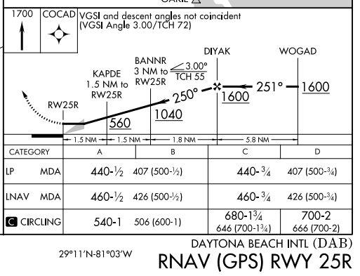
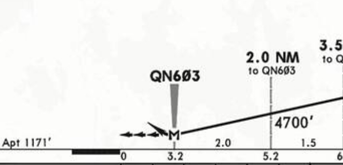
FAF is DIYAK, BUT, there are additional Waypoints on the approach between the FAD and te runway.

Asobo default code, will take the LAST WP as the Waypoint to switch from arm to active , assuming you are way down near 560 ft at the waypoint. (WRONG)

This most likely explains why some report vertical Guidance in Rnav working for some, but not others – it depends on the particular approach.

The more advanced Airlines with more advance and recent coded FMCs most likely do not suffer from this , but smaller GA planes with simpler old APs do !

Note: These are my personal finding and corresponding conclusion… without being able to review the Asobo Source code, its only my theory as to explain what appears to be happening

UPDATE:

It would appear that the above is not 100% reproducible, and the existence off Waypoints between the FAF and the Runway, sometimes does, and sometimes does not effect the decent on the GPS glideslope from the FAF.
Something else more complex is going on here – and no idea what that is.
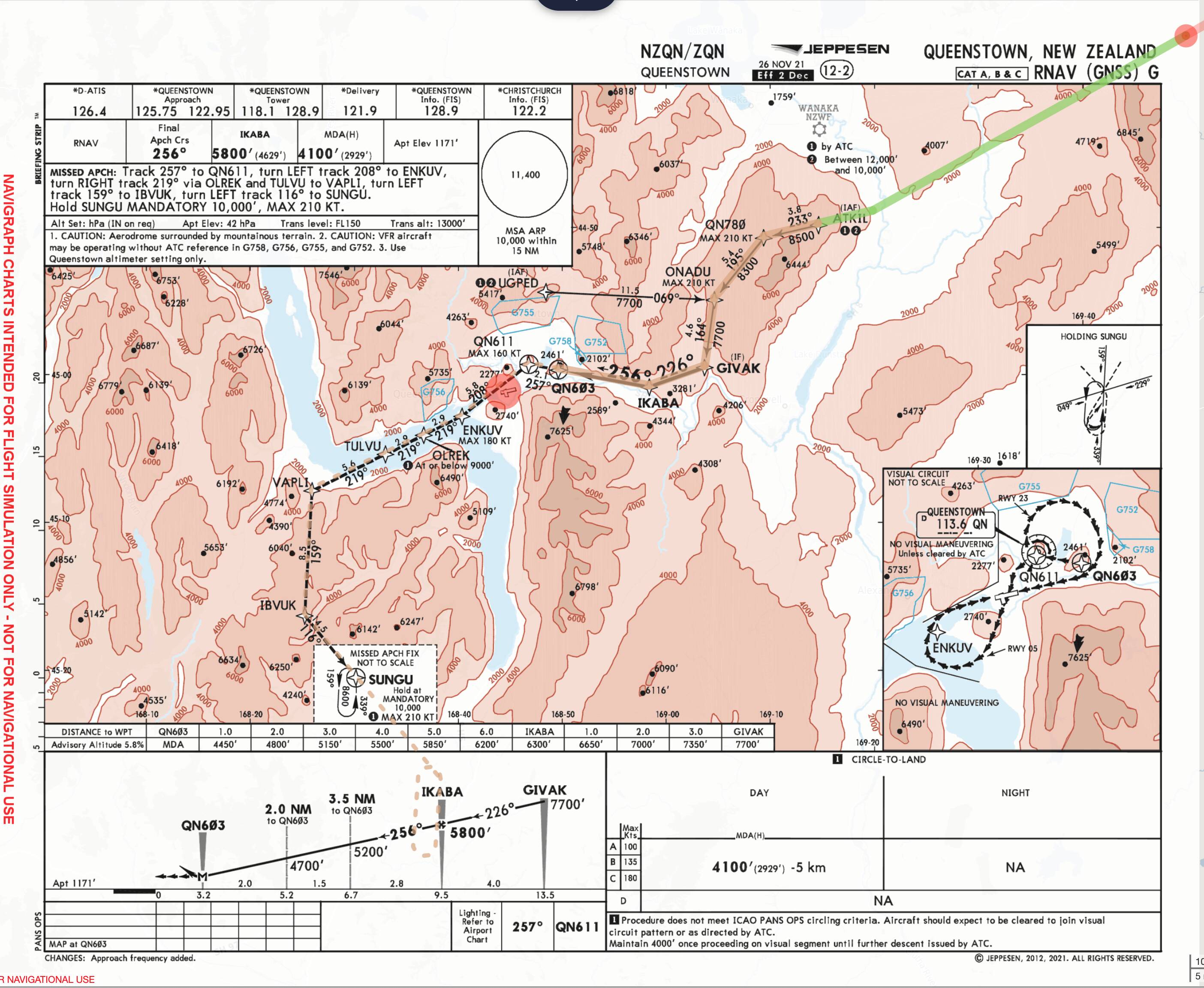
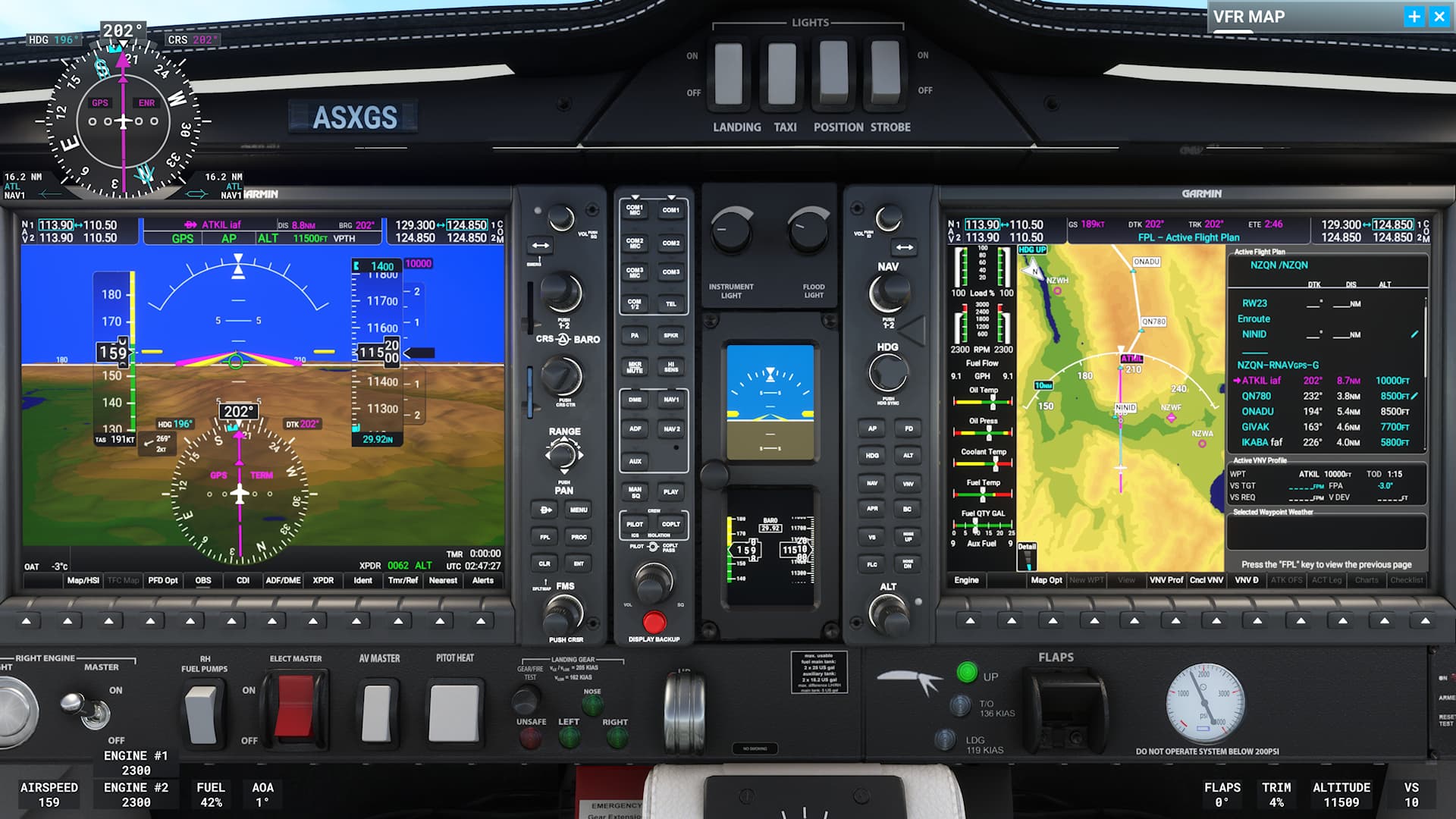
4 Likes

Very interesting,

appreciate your share. Really never noticed this problem, everytime had correct catch of g/p with rnav app, also on different distance and altitude, with all stock aircraft. PMDG 737 I leave still out of this due my expected problem what stock don’t have. Will try your examples for sure, now I’m confused if some navigraph/def nav data can play role here.

A reminder to keep this thread on topic. Avoid arguments and comments aimed at other users or their views/opinions, and focus only on the topic at hand. In future, either walk away from a thread rather than engaging in arguments, or flag it for moderator attention.

If you are visual (and sure you are able to remain visual) you could deviate from the profile and continue for a visual approach.

1 Like

Yes,

I need also ask atc for that, this is known to me.

According to the Instrument Procedures Handbook FAA-H-8083-16B, pg 4-19:

Final Approach Fix Altitude
Another important altitude that should be briefed during an IAP briefing is the FAF altitude, designated by the cross on a non-precision approach, and the lightning bolt symbol designating the glideslope/glidepath intercept altitude on a precision approach.

The presence of a FAF still doesn’t explain what kind of RNP approach it is. An APV approach (LNAV / VNAV or LPV) will still show a FAF depicted on the chart for non-precision RNP approach down to LNAV or LP minima.

Edit: I’m not sure if you post was in response to the OPs question whether this approach has vertical guidance or not. If not, disregard :joy:.

It depends on the equipment in the plane (and on how MSFS has modelled it). I can confirm that as of MSFS SU10 (Beta 1.27.11.0) the Working Title G1000 NXi (which will be default in the sim for planes that use G1000) does follow the vertical guidance of this approach - IF you set it up correctly using VNAV. That’s the only way on this particular approach because it does not have a designated runway as others above have noted, and so there is no Glide Path, you have to fly it in to the final runway yourself. But, VNAV will now work for the descent most of the way on this one.

So in this case I was at about 11,000 FT on a GPS track towards waypoint NINID, and:

  1. set the Destination as NZQN
  2. set the Approach to RNAVgps-G … Navigraph calls it RNAV (GNSS) G
  3. manually set the altitude in the approach plan to 8500 ft at QN780 to match the chart
    (user editted altitudes indicated by the little pencil icon in the screenshot).
  4. set my Altitude Selector down to the minimum for the approach
  5. engaged VNV (“VPTH” annunciates in white, then will start descending according to the altitude restrictions in the flight plan)

Normally, an approach like this would go all the way to the runway, and before the Final Approach Fix (FAF) there would be a Glide Path available to arm and capture with the APR button - but since this approach doesn’t have a runway, no GP appeared.

I believe the distinction for naming is this (correct me if I’m wrong…):

RNAVgps in the Sim (data from NavBlue) equates to all 3 of these Navigraph versions:
RNAV (GPS) in the US
RNAV (GNSS) same as above but used internationally, and
RNAV (RNP) for approaches that require more accurate precision than the above.

There is a stricter approach called RNP AR for Approval Required for very strict precision, but I don’t think the Sim has made accomodation to display the AR approaches yet.

1 Like

For anyone like me who finds RNAV vs RNP approach chart naming confusing, this video (link below) is a great video explainer.

In the US the FAA uses RNAV (GPS) to say “Area Navigation using GPS” which defines specific equipment. However because technologies evolve, and GPS also uses WAAS, the ICAO wanted to focus naming charts based on an accuracy specification independent of equipment - so that as equipment changes charts can stay the same. If your equipment can meet the specs of an approach, you can fly it.

So as of December 2022 most international approach charts that follow ICAO will use the term RNP - Required Navigation Performance - instead of RNAV (GPS) or RNAV (GNSS). But it gets more confusing because there are approaches that have very strict accuracy requirements, and “RF” (Radius to Fix) or curved legs not just straight waypoint to waypoint. The FAA calls the restricted approaches RNAV (RNP), but ICAO will call them RNP AR.

I’m curious to know if MSFS will show US approach names in the FAA format, and international approach names in the ICAO format? Asking around it seems it’s up to the particular make and model of avionics in a plane. The raw approach data has ‘bits’ which indicate the approach type and the unit translates that in to a ‘name’ you see, and that part can vary between avionics makers?

If only they could agree on acronyms life would be simpler.

2 Likes