Many of the markings and lighting for US airports are incorrect in the sim. This may seem trivial to some, but to people looking for immersion and realism, it’s a deal breaker. It can also lead to mis-identification of the runway environment (especially on instrument approaches) and misuse of visual cues that aid in landing.
Understandably, there are exceptions to these rules, which are noted as “NSTD” or non-standard, on a case-by-case basis, but in general, the following errors are occurring in procedurally-generated (non-bespoke) airports:
-
Centerline stripes are too narrow. Standard minimum centerline stripe width should be 36" for precision runways, 18" for non-precision, and 12" for visual runways. The stripes in the sim are often set to 12" wide, even on precision runways.
-
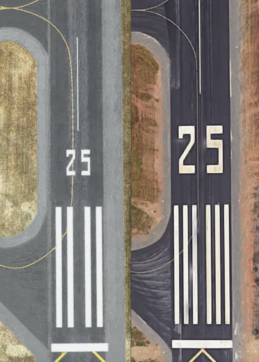
Runway designators (numbers) are too small. Most designator numbers and letters should be 60’ tall (long). They should be shortened proportionately for narrower runways only in order to meet a minimum 2’ clearance from the runway edges. In the sim they seem to be about 1/2 the height they should be, most specifically on smaller, narrower runways. This makes it incredibly hard to identify the runway in many situations.
Here is a side-by side, scaled image of Auburn Airport (KAUN) runway 25 - sim on the left, reality on the right. Note the correct runway number size at right.
-
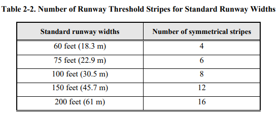
Threshold bars are incorrectly quantified. The standard is pretty clear on this:
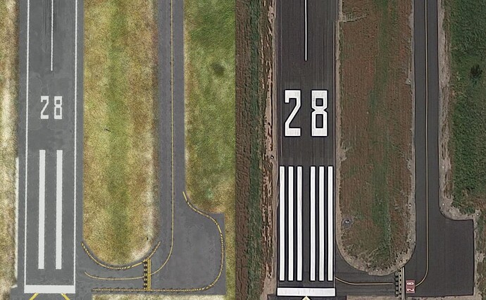
Here is a side-by-side, scaled comparison of Oakdale Airport (O27) runway 28 - sim left, reality right. We see only two threshold bars in the sim, when in reality there should be six for this 75’ wide runway. Also note the incorrect number size again, and the presence of edge markings in the sim.
-
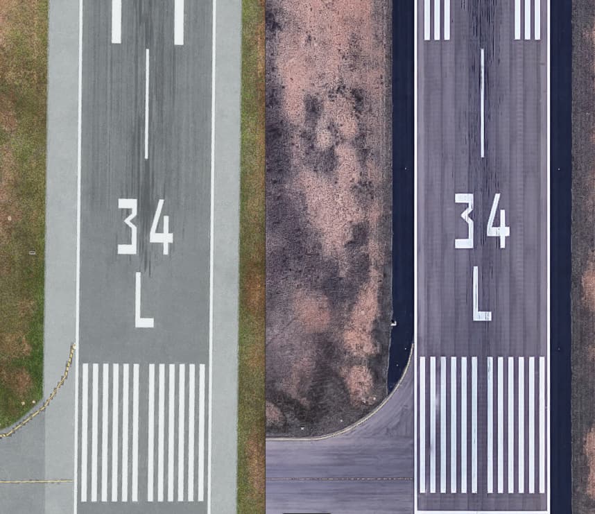
500’ touchdown zone markings are incorrect. The 500’ TDZ in the sim is a single bar close to the centerline. In reality, it should be three bars on each side of the centerline. This is misapplied on almost all US airports that require them.
Here is a side-by side, scaled image of Midland Airport (KMAF) runway 34L - sim on the left, reality on the right. Note the correct 500’ touchdown zone marking at right.
-
Runway marking borders are missing. All runway and taxiway markings (except runway/taxiway edge and rwy demarcation bars) on Portland Cement Concrete runways should have black borders to enhance contrast and visibility.
Here is a side-by side, scaled image of Rapid City Regional Airport (KRAP) runway 32 - sim on the left, reality on the right. Note the black borders on the right.
-
Approach lights and VASI/PAPI are often incorrect. This one is much harder to enumerate, but based on a fairly large sample, more than half of the VASI/PAPI are incorrect type or altogether missing. Several approach lights are also incorrect. From what I can gather, comparing historical data, the database used to generate these is over 15 years old. The issue here is that if I am on an instrument approach and brief a MALSR with a 4-light PAPI on the left and break out and minimums and see an ODALS with a 2-light VASI on the right, that’s a go-around. This does not address the incorrect longitudinal placement of many VASI/PAPI systems, and/or obstacles encroaching into the FAR 77 clearance plane while on said VASI/PAPI, which is worthy of an entire thread.
A few examples of incorrect lighting:
KSAC Rwy 20 missing P4L (4-box PAPI, left side). Rwy 30 has V2L, should be P4L (since 2009)
KLHM Rwy 15 and 33 have V4L in-sim. These were replaced in 2007 with P4L
KRNO is missing all five PAPI installations
KCXP Rwy 27 has V4L in-sim. These were replaced in 2008 with P2L. Also missing REIL
KPVF Rwy 23 has V4L in-sim. This was replaced with P2L in the mid-2000s
KOVE Rwy 31 has V2R in-sim, should be P2L
KMYV Rwy 14 has REIL in-sim, it should not
KMOD Rwy 10R has P4R, it should be P2L
KRAP Rwy 32 has P4R in-sim, this should be a P4L
KTVL, a bespoke airport, has runway centerline lights. These do not exist in real life at KTVL
KSEZ and KPGA have taxiway centerline lights. Taxiway centerline lights exist only at a several dozen airports in the US, neither of which are these. This seems to happen a lot.KEAT - here’s an in-sim pic of the approach to Rwy 30. Note the V4L and ODALS
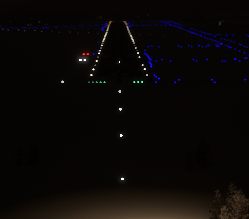
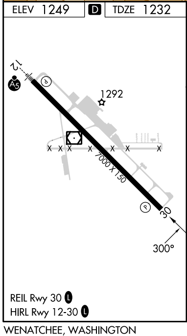
Here’s the current approach plate, note the ODALS was removed, a REIL installed, and a P2L replaced the V4L. This occurred sometime between 2006 and 2009.
The list goes on and on and suffice it to say there’s a major lighting error at nearly every airport I surveyed. These databases are updated and published by the FAA every 28 days (see “Airports and Other Landing Facilities”) and should be able to be parsed in order to correct these issues. With nearly 7,000 PAPI and 600 VASI installations in the US alone, this is very worthy of correction. (Note my area of expertise is in US systems, not rest-of-world, but I’m sure those are worth a look as well).
My analysis was performed using current and archived Airport/Facility Directories, Terminal Procedure Charts, Historical Google Aerial Maps, facility databases, and FAA publications such as FAR/AIM, and Advisory Circular 150/5340-1M "Standard for Airport Markings (warning:PDF)."
