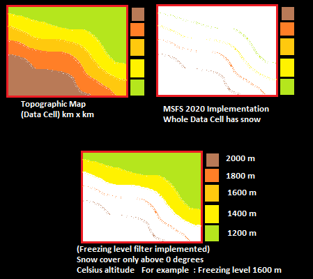
Generic snow coverage is a result of low resolution data. The Meteoblue snow coverage data can’t distinguish if there’s snow lower down the valley , since the whole chunk (which could be several km x km) says “There is snow there” .
This could be solved with higher resolution data, which is an extremely difficult task because snow/ice coverage globally isn’t always accurate, characterised by low resolution maps most of the time. In my opinion , it is almost impossible to have the extreme detail needed to see a valley in Switzerland with no snow cover(at least at this age and time). Each chunk , will still have generic snow quantities , based solely on the resolution of the data. This is only solved with better satellite scans ,but still the data could be 1-2 days old.
Also I still don’t know which data they are using right now in MSFS. Meteoblue has some pretty hi-res data for snow, but I’ve never experienced snow coverage following their data. Maybe MSFS is using a lower res version or something. This is a place that they could improve on.
Meteoblue estimated snow depth
Europe snow cover map (4x4 km data resolution) (13.1.2019) IMS snow Analysis NOAA
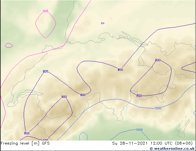
A fast/“simple” solution could be implementing a secondary data calculation that “filters” snow depicted on the ground , depending on the freezing level data (zero degrees isotherm) and ground level temperature ( rapid snow melt above 5-6 degrees Celsius). A simple example , the data cell/“chunk” could say that there is snow in this area even in lower altitudes within the data cell area, but implementing a single factor such as freezing level for example, could create snow-less valleys and snow covered mountains.
Still , this can’t be as accurate as we need it to be, but can potentially be accurate in specific occasions (such as the Mediterranean region). This solution could still result in snowless valleys ,when in reality there is indeed snow cover there at lower altitudes, or the snow hasn’t yet thawed because it was several centimeters thick. Another problem could be the quick rising of the 0 degrees isotherm , leaving mountains with deep snow in real life, snow free in the sim.

Adding different weights for every single variable(Ground Temperature, Freezing level, etc) and by combining them all together, could also potentially yield a realistic result if implemented correctly.
Switzerland freezing level map

In my opinion , the perfect solution that could yield the most realistic snow cover map for the whole globe (and I don’t really know if there is something like this out there) , could be the creation of a new weather modelling system/map, that takes past and present snow events from the combination of precipitation maps and snow occurrence level (altitude) data (* which similarly to freezing level maps, exist within certain weather models) and combining them with the last 14 days simulated snow cover (simulated using the variables mentioned above), the system then covers a high res elevation map of the whole globe with highly detailed snow coverage data. Adding snow on past snow coverage data, and thawing parameters such as temperature/rain can refine the final data even further. The result is a snow accumulation map that is not only elevation-specifically accurate , but it could also potentially be very accurate in depicting snow thickness as well, which MSFS is able to use too. The “ultimate” solution is given again, for dynamic snow coverage this time, through the complicated use of weather models, which highly depend on their (again) data resolution .
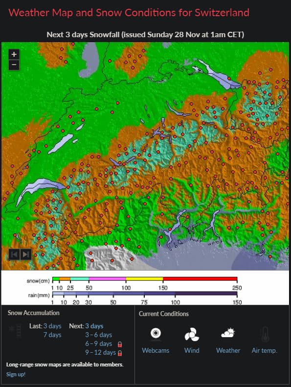
Snow-Forecast has maps with snow cover projections that show what I am showing here as a solution with the use of elevation maps. Last week snow coverage maps too.
WXCHARTS has something similar but a little more complicated and closer to what I am describing here.
Of course maps like these exist on Meteoblue too.
Still, getting even closer to the “real” thing, is an extremely difficult task that follows closely technological breakthroughs in satellite and weather modelling fields.
Real satellite image of Switzerland in September. This is the snow cover variability and accuracy we would like to see sometime in the future modelled in the sim.
Snow-Forecast example in Switzerland using elevation maps in Nov 2021. Southern valleys have no snow but rain since snow level is higher there.
Final example , snow level forecast and precipitation map : Greece


