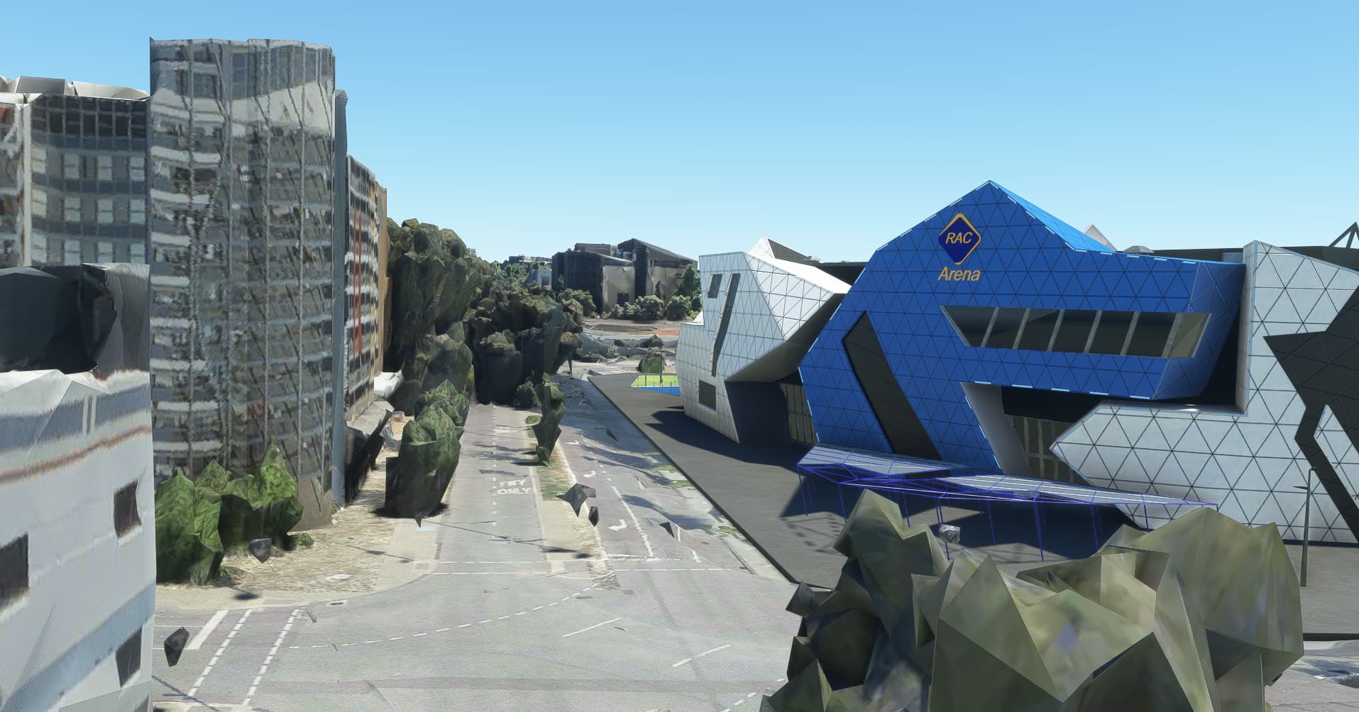
As I remember (Oct 2020) this issue has always existed in MSFS… For the most part, you see these rocky trees in the cities, spoiling the surroundings of POI’s ! Below RAC Stadium, Perth Australia, latest world update. In this case especially bad, because tree-rocks and trees are placed wrong also: they appear in the middle of the road,
My speculation: could these be labeling errors,that must be resolved by changing Blackshark data ? these trees are actually classified as unknown objects, or green buildings ? guess ? In above screenshot, there are some “normal trees” too, which do not seem to show any rockyness… and they are placed correctly.
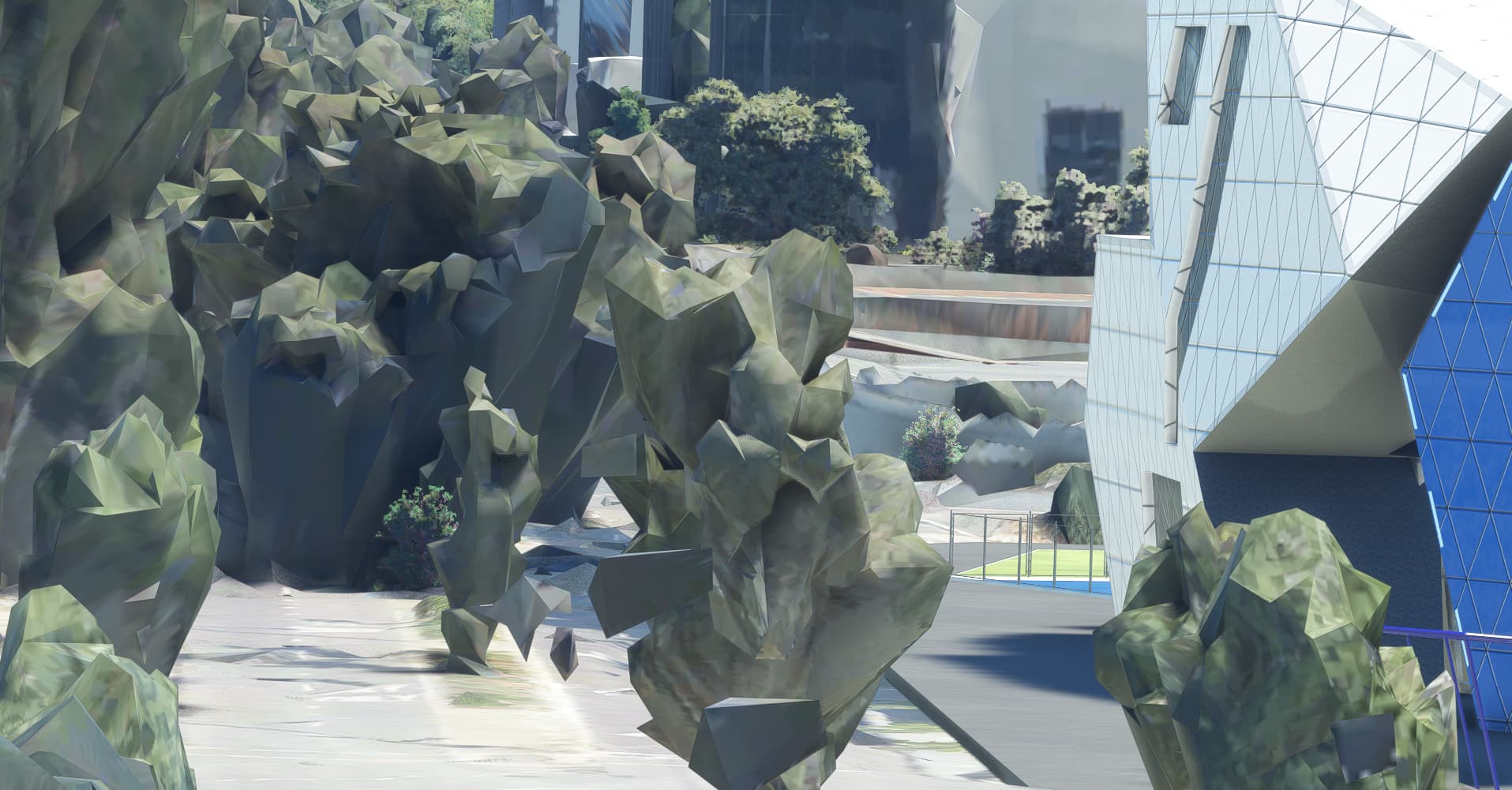
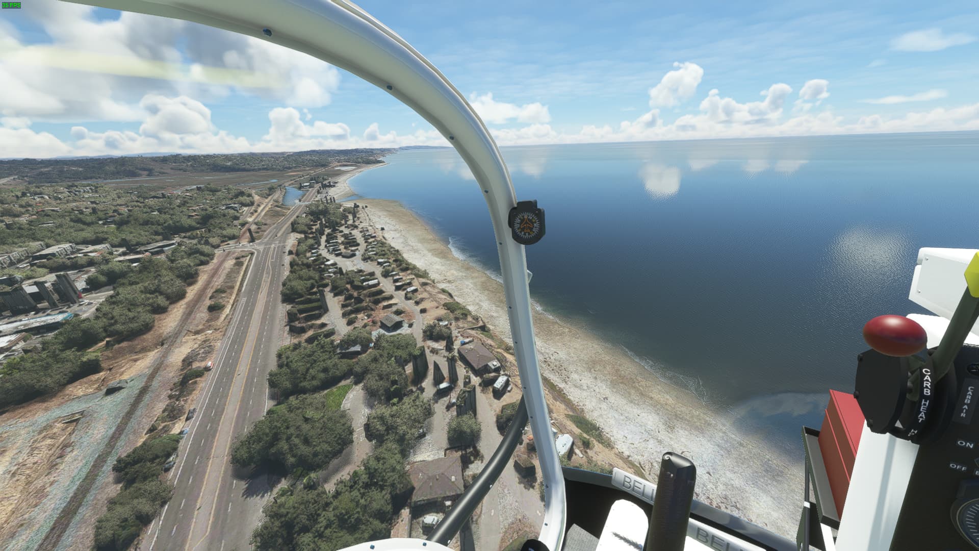
The rocky ones are almost always wrong placed, here is another example in Perth, road got blocked,
For the main part WU featured PG cities get main areas de-treed but it’s by hand and scenery has to be improvised in the void that they leave which would be extremely difficult using AI. Outside PG it is obviously much simpler.
1 Like
It has to be “pruned” manually, I guess… per location… using some kind of scenery editor, put it 90 degrees top view… and then carefully polygon-mark and remove everything that sits on roads !
Sure but not all trees are free standing and the face of whatever is behind never photographed. I kind of suspect better data will sort it eventually, maybe both summer and winter captures…
1 Like
I see these in certain locations, such as around outlying areas of Los Angeles. When I do see them, they are there consistently. I have wondered if it is a streaming issue, even though I have a strong internet connection.
No its not internet, as I said earlier it needs hands-on attention and outlying areas are never as important as the next city’s city centre scenery (whew!). Simply put:- the world is a massive place. Lesser quality buildings in the outskirts happens too for similar reasons, the photographing plane just isn’t going to be flying as close unless it’s en route.
1 Like
I’ve seen them in cities and suburbs. @DensestSnail693 keep in mind this is about rocky trees, not about other issues.
I do and I also keep in mind that it is far worse in the few PG cities that have escaped the attention of Asobo … I’m pretty certain the rocky trees are drawn by A.I. particularly because the originals present time of day shading difficulties and that they (the rockies) have very few vertices, with so many trees in some places this is essential for performance reasons.
I suggest you find Wuppertal (east of Dusseldorf), great unadulterated PG but lot’s of these lousy trees. You don’t need the DACH update to fly there.
Thanks @DensestSnail693 , I have found that many of your responses on this forum are informative.
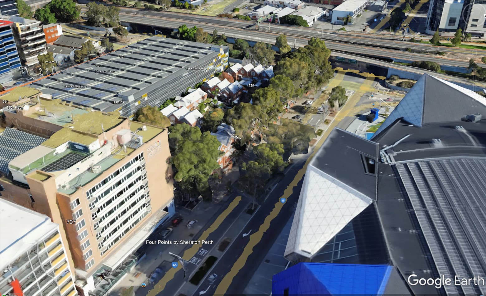
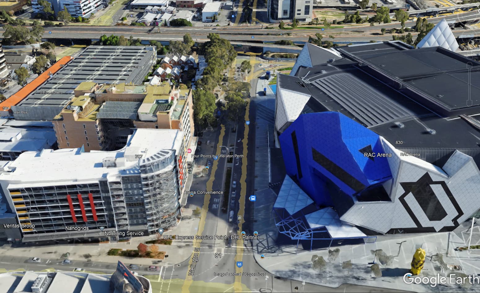
This got me curious… are there actually trees at that spot ? Google Earth also shows trees, only a few trees, not a forest…
There’s not many RW photographs showing this angle, but it could be some kind of park there,

In any case, I have to correct myself, there are trees on that spot… but they look bad in MSFS. Really bad.
The “rocky trees” are simply low-resolution photogrammetry trees. If you pull up Perth in Bing Maps you can see the same geometry as in your screenshots, it’s just a bit higher resolution. They’re not really incorrectly placed, this is just a known limitation of photogrammetry.
The “not rocky trees” are AI placed autogen based off the aerial imagery.
A fix would involve a post processing pass on the photogrammetry data, identifying vegetation by color and or shape, culling those vertices, filling the hole with a flat patch based on the adjacent geometry, and then placing autogen vegetation in its place.
I’ll vote for such a feature for sure, but it might need to be relabeled as “improve photogrammetry vegetation” to get more votes or understanding from the devs.
2 Likes
Rocky trees is how photogrammetry works. Currently the devs take those cities in photogrammetry and place non rocky trees on top of the rocky ones to cover them. This is probably done semi automatically but it still requires a lot of dev time from we have been told. If you remove those rocky areas, there is nothing below. The area will be black. The removal would also have to be manual. Hundreds of dev hours per city.
One solution would be to place satellite images under photogrammetry but then there is a risk they will not overlap perfectly and the visual result might be even worse.
Until we get better quality photogrammetry, i do not see a viable solution to this. Mind you that better photogrammetry would absolutely tank the performance even on best PCs currently available.
Currently to do this in dev mode the only way to remove those rocky PG tree’s is to do a terrain flatten but that means you can’t always get them all without flattening or warping the pg objects if they are close by.
Quite often when you flatten the tree’s the sim will replace them with a modelled tree but will leave a 2d green spot of the tree below.
Doing those things above can take hours and is extremely tedious.
The rockies are definitely A.I remnants from an earlier solution and the non rocky one’s which cover them are also A.I only better. Apart from size this works great in the countryside where they can also de-tree but in PG cities and such it obviously needs some manual oversight which is why it’s sometimes neglected in the suburbs. I’m pretty certain newer data is the answer.
Would that be downloaded data (dynamic, automatically) or is it required to an update ?
Bijan Habashi’s Seasons mod concentrates on trees and their state through the seasons all over the world and he’s doing an excellent job of adding realism in this respect. He’s done a lot of work on photogrammetry areas but of course, as already said, this is pretty intensive dev work and takes time. In no way is everywhere covered but if someone points out a problem area he adds it to his “todo” list.
The mod is, of course, payware (from Simarket) but all updates are free and pretty frequent. His latest is an app that automatically loads the correct seasons, although you can still do it manually if you prefer. He also has a few other tricks, all aimed at improving the visual aspects and with little to no effect on FPS.
But for the OP’s question it goes a very long way to making the improvements requested, especially as Asobo don’t seem inclined to do it themselves. But maybe this is what 3rd party content is all about; after all MS included a Community Folder specifically to add third party work in to the sim.
1 Like
Those are actually the best looking photogrammetry trees I’ve seen. All the areas I normally fly the trees look like someone threw a tarp over the tree with a distorted tree texture on it. Palm trees being the worst looking of them all, just weird monoliths all over.
PG trees looking bad are to me the biggest issue with photogrammetry in this game.
1 Like
Well, I don’t appreciate them near a POI… suppose you worked on that and see the result… there’s much more effort in the POI than removing a few rocky trees…
Do you all know what I’m talking about when I bring up the issue palm trees currently have in Southern California for example? The AI does not understand what to do with palm trees and turns them into tall monolith towers instead of a palm tree model. Totally immersion breaking. I hope they can fix this issue by improving the AI recognition for its season update or something because it’s kind of ridiculous.
Here is an example of what I mean. Look far left side.