Strange localizer behaviour (SUMU)

On today’s flight, I ended up with quite a few issues during approach, and before I try to report it I’d rather ask if I haven’t done something wrong here.

Just so everything’s clear, here’s the approach chart for my planned procedure:

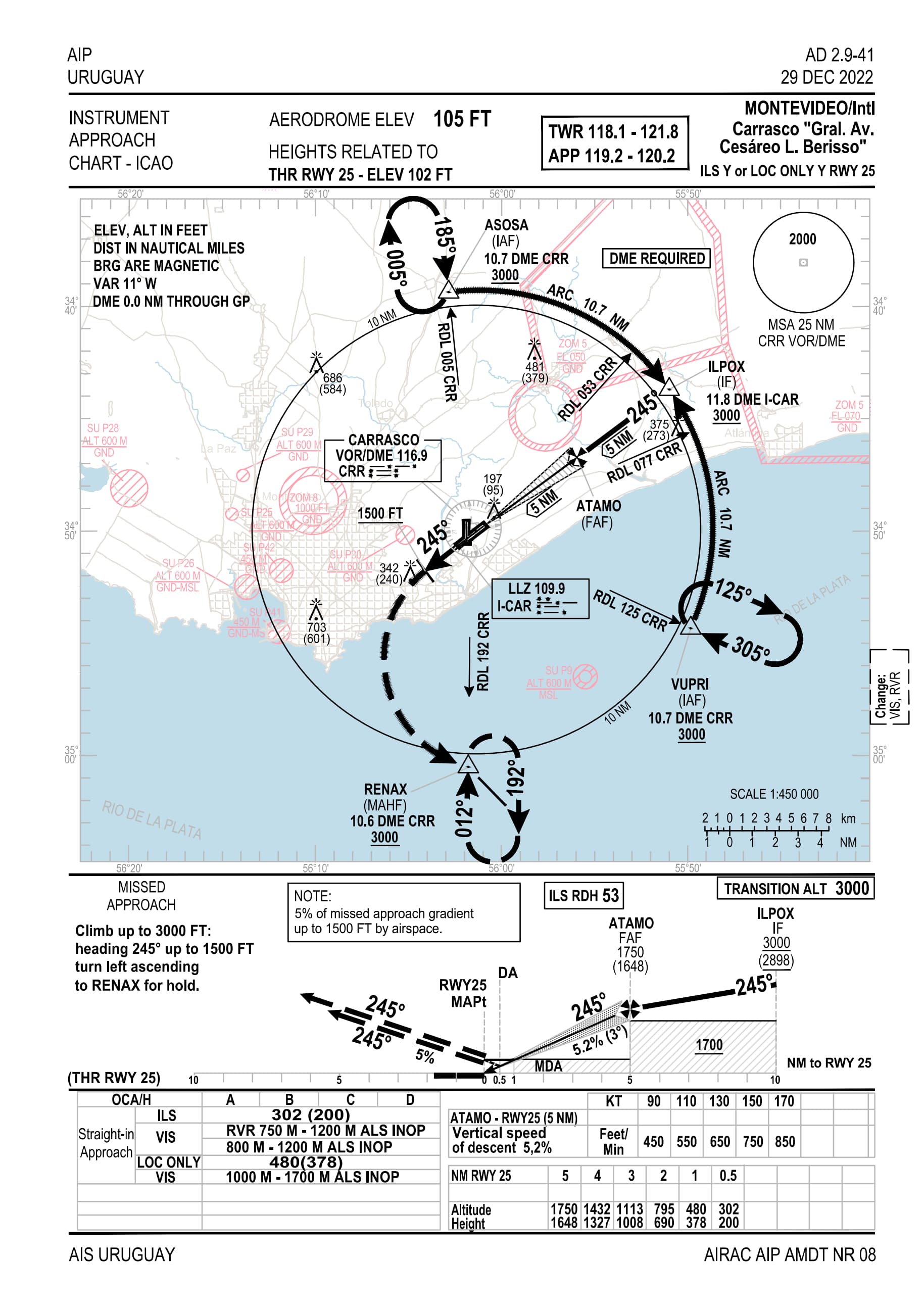
When coming close to VUPRI, I realized the localizer’s arrow didn’t show up on my PFD, unlike the CRR VOR; after some struggle (I was flying CJ4, and used mouse in a bit of turbulence) I verified that the option was disabled despite the correct frequency being tuned in. I waited until it was time to capture, at which point I switched to an LNAV/visual ad hoc procedure and landed.

Having done that, I turned on dev mode and found that the ICAR localizer DOES exist, and broadcasts on 109.9, except for some reason it isn’t picked up as an ILS signal? There was even lateral and vertical guidance once I picked NAV1 as source. But, there was no glideslope when I turned on the relevant view in devmode.

On the VFR map, MSFS only gave the ILS 19 frequency. Other systems had the same problem, too - I checked the Garmins 3000 and 1000, both only reported a single ILS available. It’s not an add-on issue either, as this behaviour persisted after disabling every one.

I don’t know what could be causing this problem, and whether it’s my fault for misunderstanding something or an error in the scenery.

(On a side note, this airport is one of the reasons I’m hopeful for World Hub - the runway is still 06-24 in the game, while procedures etc. apply to the new designation 07-25. For this reason the CJ couldn’t calculate my landing speeds, as it was unable to pull a runway 25 - at first I thought this was the problem, as I ran into this when landing on Easter Island. Procedures also go wack when this mismatch happens)

If it’s not listed in the G3000 then it’s probably a case of the beacon existing in data somewhere, but not the approach.

There’s an oddity in how Flight Simulator understands ILS / Loc Only approaches because it doesn’t actually understand them based on an ILS beacon existing, but on a bit more information.

Also, with one of the latest sim updates there was a change in the standard for this information and AAU1 changed how that information is consumed to use the new standard.

If you aren’t using any 3rd party scenery (including marketplace) which it seems like you aren’t from your description, I’d report this as a bug to zendesk.

There’s definitely some issues with missing freqs and approaches in the sim for that airport. Those need to be reported.

However, to clarify a couple of things about the approach and your comments. If you’re near VUPRI you won’t get a localizer signal since you’re nowhere near the narrow broadcast cone for a localizer signal. You’re going to have to be near ILPOX to get a localizer/GS signal to show up. Unlike a VOR which can be picked up from any angle (minus distance/interference issues), Localizers can only be picked up if you’re within the relatively narrow lateral broadcast area, identified by the small “fan” coming from the end of the runway toward ILPOX (the signal goes out further and a bit wider than the fan shown on the chart. The fan is just there to give you a visual idea of the ILS coverage), and if you’re within range of the localizer transmitter, which you will be at IPOX.
So if you’re coming into VUPRI, you need to fly along the DME arc shown on the chart (10.7 NM DME arc) until you’re near ILPOX, and then you’ll get the ILS broadcast (both localizer and glide slope signals) and can follow it in to the airport.
IF the approach was correctly modelled in the sim, and you activated the approach, the Garmin would fly the DME arc for you.
Regards