I dont believe this is possible yet. I say let them sort out live weather before even attempting to add historical weather to the mix lol. Once they got that under control, it would be a great addition though
3 Likes
I don’t know if this was mentioned, but I flew into the typhoon just south of Japan and noticed that while the wind is good old 225/03, the waves were crazy inside the typhoon. I started the flight off the edge of the typhoon and the sea was calm initially, then waves were getting stronger and there is absolute hell near the center. So, the wind is there, it just doesn’t have any effect on the aircraft. “Bubble” theory has been kind of confirmed.
2 Likes
Maybe it’s this, update date 24 Sept are on DR MAP, there is one update per month on average, must be loged to insider to see it “September 3rd, 2020 Development Update - Microsoft Flight Simulator”

1 Like
Why do we have to wait 18 days if they have already fixed it? Just roll it out to us.
Probably because they are either trying to stick to some kind of cadence, rather than what one user desperately wants. Or they have other fixes they hope will make it in, making one larger patch.
2 Likes
I think I made my comment before they released that, or at least before I saw it anyway. I’m glad to see it’s been recognised and being addressed.
You have the Tech Alpha Insider badge - Did you have any experience working with Developer/Preview/Test Build software previously? They will be checking that it actually has solved the issue, along with checking it’s not going to break anything else (to the best of their ability) and also with the number of fixes they’re going to be ejecting, They probably want to ensure the patch they release works with whatever the ‘other team’ is working on…
1 Like
Maybe just use the manual controls on the car to set the weather to whatever you want until then I suppose.
You probably right. However, I reckon the amount of people who raised this since January and the number of votes it currently has puts it at slightly more than one user who wants it.
1 Like
Didn’t fly into typhoon itself, but in most parts of Japan 3 ktn wind bug is in force. Japan is my primary flying place and never I saw any wind affecting plane, though sea waves are corresponding to very windy conditions, and ATIS, and weather report on intro screen show correct wind (~30 knots).
1 Like
This has possibly been discussed elsewhere in the forum… but I haven’t seen it so maybe someone in the community can set me straight. To start, I think that we generally agree that both weather injection (imposition of atmospherics on the flight model - 225@3Gate) is partially or completely broken, and that “live weather” is also partially or completely broken. Let us assume for the sake of this thread that the developer corrects both.
What is “live weather?” In English, the implication is that if I look out the window of my residence and there is a thunderstorm, I should be able to fire up the simulator and there should also be a thunderstorm with roughly the same characteristics at the same location. But is that actually how the game is even intended to work?
It struck me that it would be pretty tough from a programming perspective to do that world-wide. The only way would be the import and parsing of things like weather radar - something that not everywhere in the world is lucky enough to have (not everyone has an organization as well resourced as the NWS in the US, or the MET in the UK). Even if you used METARs from every site in the world, the space between those sites would have to be generated using some sort of approximation, and certain phenomenon like storms would be placed randomly in space around the METAR site. Development wise, it would seem easier to recreate weather based on a forecast model (which is worldwide) such as the GFS, NAM, ECMWF, etc. However, that is not “live” weather.
It would be nice to see a thorough explanation from the developer, or someone else knowledgeable about how “live weather” is implemented. As this was a major selling point for me in purchasing the game, I’m curious if it is ever going to live up to my expectation of what “live” means. I have a feeling that I’m going to be disappointed, and that this is deceptive marketing on Asobo’s part. They probably need a different word like near-live, or close-to-live, approximated or forecasted weather… Anyways, if anyone in the community could enlighten me, I would appreciate it.
2 Likes
all i want is for it to be as good as active sky for p3d is… if asobo cant do it, then open up the sdk so hifi can step in.
2 Likes
I’m sure this will be improved greatly in the next patch.
I bet the 225/03 wind is the default when the sim can’t parse the data coming in from MeteoBlue. I’m assuming that’s likely the issue, but I’m not sure.
1 Like
Yes, I also wondering about “Live” weather implementation conserning multiplayer. Is the weather globalized and identical for every player. I can see quite often a very local weather penomena in sim, like local rain, a huge culumnus cloud, etc. So if one player in multiplayer world (or say if it is a closed group) fly into the local cloud or rainy or foggy area. Will they appear in cloud (rain, fog) to other players. This actually may have significant implication for group flying (like bush plane tours with friends).
My thread got merged with this one, scrolling back through it I still don’t see anyone taking a stab at what “live” means. Data comes from Meteoblue… okay… but what kind of data, and what is the game doing with it?
I’d settle for asterisk, like MFS2020 has Live Weather*, scroll down to the fine print and it says something like: *Weather is an approximation based on forecasted conditions. Experience may vary.
Live forecasts are not live weather. Sometimes forecasts are wrong, sometimes they are low probability. I can see the game having a huge problem with representing something like diurnal convection accurately.
Anyone want to take a stab at this? 
From what I can gather, most reasonable people expect Live Weather (granted, populated places where people live and weather is seriously monitored and tracked) to be within 15 minutes and of about 85% accuracy of it’s real life counterpart.
Winds should be 95%+ correct as it’s just a number.
For weather in the most remote areas, weather should mimic the best of what gathered reported data can determine, based on measured and predicted.
Only the extreme people want 100% realistically weather down to the minute, but that’s well, unrealistic. But it should be close it enough it passes for real.
so if a thunderstorm is coming towards to a certain airport, the game should have that same front there. Hopefully synced enough to live traffic that planes aren’t flying through the middle of a game thunderstorm thats 30 minutes delayed, but again, thunderstorm fronts can be fast moving, so i feel we will continue to see this, especially as air travel picks back up.
I don’t disagree with the expectation framework that you laid out.
In the United States, official observations at government stations are updated every 20 minutes; and, depending on the volume coverage pattern being used, 5-10 minutes for full weather surveillance radar refreshes, and twice per day for radiosonde launches.
Not everywhere in the world has this sort of thing. If in the simulator you choose to fly over a less developed area, will the “live” weather not be represented at all? Just CAVOK all the time?
This is why I have a suspicion that the simulator is being fed model data instead of observational data. It would be easier to implement, and world-wide. I suppose it could do both - that would be very impressive.
Think of your example of a thunderstorm coming towards an airport. The exact structure of the storm, and its position, course, speed and dimensions are only defined in weather surveillance radar. The game engine would have to be capable of parsing and drawing that. A METAR may state that there is CBs nearby, with lightning reported, but it doesn’t contain storm position and structure information.
So my question remains, what is “live” in the context of the marketed feature “live weather?”
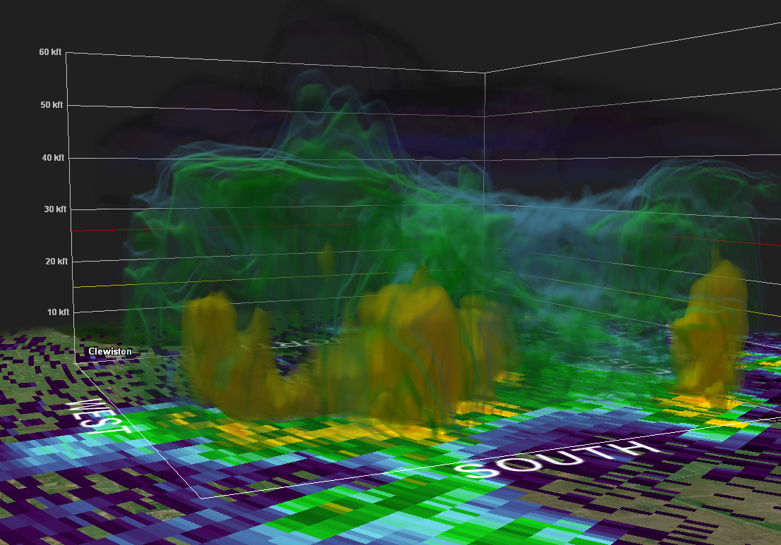
This “live” - yes, right now - image is from the terminal doppler weather radar at KPBI. I launched into the game just now, and a storm with this structure is nowhere in sight.
Meteoblue is sending live weather data to Flight Simulator from their own in-house numerical forecast model. Not sure on the resolution, but their global model has a 30 km grid I believe. Overall and especially in rural areas, it should have much better spatial resolution and depth of data then relying on parsing old METARs. If they actually implemented it, which they apparently haven’t.
2 Likes
Uhmm… Fishdude, have you actually watched the Meteoblue explanation from the Partnership series that Microsoft released on Youtube? It might answer your questions, i think.
Here ya go m8:

Kindest Regards,
Steiny
1 Like
Short of using real time METAR data from a number of reporting stations all in close proximity it would be difficult to place a cell in-game where it is actually occurring. Active Sky does this quite well based on METAR data, and sometimes it is surprisingly accurate - sometimes not.
NEXRAD radar data would be the best way to place thunderstorms accurately in those countries where it is available, which include the US, much of southern Canada, large parts of Europe, and Australia. I know that in the US, one can view local NEXRAD radar in real time at no cost on weather.gov, but not sure how easily that could be imported into a simulator.
I’m 95 percent certain that the live weather in MSFS comes from MeteoBlue’s NEMS global forecast model. Like any model, sometimes it can be very close to current conditions at a given place and time, sometimes less so.
In the case of thunderstorms, it can be very difficult to forecast the locations of summertime airmass storms that could potentially pop up almost anywhere if the heat and humidity are high enough. Even local NWS forecast offices often can’t do much better than to predict “A 50 percent chance of storms after 2:00 PM ” for a given location. A recent “pop-up” storm dumped 2 inches of rain in 30 minutes at the local airport, but at my house just 7 miles to the south, not a single drop of rain fell all day.
US National Weather Surface offices generally use the GFS or NAM forecast models, but sometimes they will favor the European or Canadian models for certain types of weather systems.
Storms associated with fast moving cold fronts are much easier for any model to “foresee” in terms of location, timing and intensity.
I live in New York State. Several days ago, we had a severe thunderstorm outbreak along the south shore of Lake Ontario. All the forecast models predicted in advance that the storms would form shortly after noon near the lake, and would move southeast across the state towards Northeastern Pennsylvania through late afternoon. Indeed, they formed and moved just as the models predicted, and the cells were present in MSFS at the correct locations and times.
1 Like
Even when there is actual wind, it is still underwhelming. I remember the first time I flew into a thunderstorm in X-Plane and my Cessna got WRECKED. The wind in this game does nothing except jostle the plane a little. There is no challenge to it, especially if you are doing an ILS landing.