The manual cache behaves as though it’s written with just a single thread maybe 2 threads. A slow unresponsive UI is indicative of the calculations happening on the UI thread.
Actually, the cache can have the download size info provided on screen, just needs to (now it might not be programmed to permit this way) send the current job as a temp info job for the download size. There might a surprising amount of info already available just not plugged into the visible window.
Yes, the UI can use more work including the legend boxes - which prohibit any selections where the mouse hits the legend boxes. The selection box screen can have the legend docked probably to the top, or maybe the sides as 1/3 of the screen is currently full with legend detail.
The premise of a cache makes sense. If you fly over the same area day after day (figuratively or actually), then there isn’t reason to download the same data again and again via streamed data (or updated every 6 months of new ground activity)- hence the cache. I’ve flown to several different areas but the cache reached maybe 12-16GB (size on disk)? It’s likely compressed very well at that rate.
The rolling cache will (should) cycle out older data when the cache size is maxed, hence if you have favorites-the favorites can be saved in the manual cache and won’t be cycled out unless we delete the region.
2 Likes
Mine, is not working anymore. After the latest patch, it just freezes. Before it was working fine and I had downloaded a large area in high res.
1 Like
Bing satellite imagery should also be included in the manual cache. Don’t think it is at the moment and always streamed in.
New MSFS patch 1.9.3.0 corrected the manual cache. It now behaves so much better - I can actually scroll around with multiple regions already cached.
1 Like
i did see some improvements but not the download part. it still takes forever to download. im on a 300gb down/400gb up internet but i cant seem to download a medium map of Luzon, PH.
here’s guessing there is some throttling (maybe locality based too) to help manage the servers with so many people, and it’s probably not just the MSFS crowd but also the Bing Map crowd too.
It took maybe 15-20 minutes to download a mixture (low, medium, high) of Oahu island.
I’m glad I can pan around and zoom in without a 2 hr nap in between each mouse click.
1 Like
Hi There,
I want to manually cache the entire Netherlands.
But it’s a tedious task to zoom in so much to actually get a small part done.
Can’t we just click Low / Medium / High and drag our selection?
Would make things alot easier.
Or make countries selectable and then a dropdown with quality and download button.
Hope I am not the only one that wishes this to be implemented and would appreciate a vote so the Asobo team sees this.
It took me an hour to mark up the whole region as medium and it crawled at the end. My GUI is locked up trying to get it to pause/abort/take any action.
I recommend splitting the Luzon, PH region into 8 or 10 zones. I think the manual cache is designed for like 100-200sq nm areas, which are very quick downloads.
1 Like
Indeed. It would be better to have an option to select higher resolution from a larger distance. Also if the download size was displayed first (before asking to download), it would be perfect.
1 Like
Getting CTD when download starts
Puerto Rico - medium map with a few High around San Juan, that’s a 45 minute download
it might not be a linear increase in area vs download time, maybe more quadratic == more time to download a sq NM when more area is selected
The current process to set up the Manual Cache is really tedious, especially if you want High Cache quality – can take hours.
How about:
- letting the user paint the entire area they want to cache, eg. South East England, from a high altitude/zoomed out level, covering the entire area in relatively few paint strokes, then
- choosing what level of cache, Low, Medium or High they want?
This will hugely speed things up, make the process far easier. Editing out unwanted bits can happen later, once the full area is selected.
I agree that having a quality selection option for the highlighted areas vs. tying it to the zoom level would be much more ideal for caching larger parts of the map and would also ensure that users are getting the cache quality they desire.
The current design is time consuming by having to zoom in and out on the map and can be confusing to the end-user. The map should also have locations and points of interest marked to make it easier to navigate overall.
1 Like
I think it will be a good idea to indicate how much free or available space I have when adding new regions.
Yeah, I can’t believe they don’t already have this option.
I have been trying to use the Manual Cached Region function for a bit now. Have no hair left, but moving on.
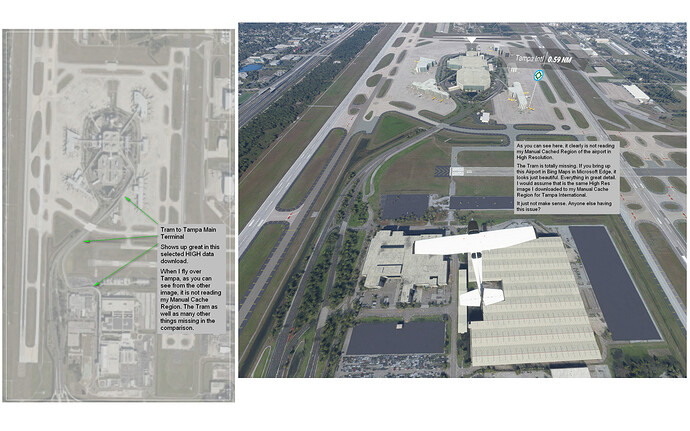
As you can see from the 2 photos I uploaded, one is the view from the plane flying over Tampa showing the airport in lower resolution despite the fact I indeed downloaded it to a Manual Cache Region in High Definition. Is there a reason the High Def region is not showing up?
The High Def Region shows the same image within Bing Maps via Microsoft Edge. Not sure how to make it show up when I am flying. Any suggestions?
Hey whisky. The manual cache at the moment only seems to affect photogrammetry. Although even this function id not working properly. But to answer your question to the best of my knowledge, airports are an exception to the photogrammetry rule. If your airport is not an addon or one of the Asobo hand crafted items then the airports are subject to the blackshark ai analysis and the data is used to create an airport from this data and the satellite imagerie and is replaced by this generated model. Things like the tram way for example are not modelled because this is not part of the airport algorithm. From what i can see it replaces buildings, runways, taxiways markings and textures. For example if you look closer at the ramps you can see the outline of aircraft deleted from the satellite image, the same can be seen with the taxiway markings.
To cut a long story short manual cache will have no effect on airports with the exception of the surrounding area. If you want a better airport you need to see if there is some freeware addon or if not payware.
Hope this helps.
1 Like
Having additional options to link Manual Cache to a flight plan is a fantastic idea.
This would ensure everything along your flight plan look as best it can.
Even a feature that let you look at your flight plan while in the Manual Cache would be nice so you can isolate just what you need.
1 Like
I have seen previous posts about this but I have yet to see a fix. The selection of manual cache is a real problem.
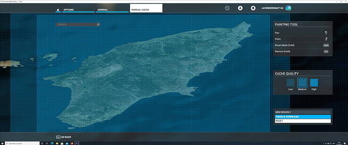
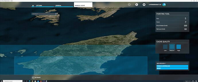
First of all the ereas (even the whole earth) appears to be at an angle (at YouTube videos I don’t see s.th. like this). Then when choosing an area, after having selected e.g. medium resolution and trying to pan the map in order to focus at a particular point to select it with high resolution, the map moves but the selected area doesn’ t follow, rather moves out of focus and NOT with the map. This makes it impossible to find the area of interest and select high resolution. I have included 2 pics to illustrate the issue again.
Is MS intending to fix this at all? Fellow simmers have suggested some interesting points on this but is anyone listening?
I agree, I just decided to dive into the manual chache and try to select a large region for download. The current manual cache is a joke… Its not easy to download what I want in the resolution I want not to mention the distortion effects of moving the map around. I am going to submit a zendesk report to see if I’m doing anything wrong, but this shouldn’t be that hard…


