If I am on Vectors to Final, the PFD/ND isn’t going to reflect any course that ATC assigns me. I’m not being asked to fly to waypoint A, B or C, which I suppose one could program into the FMS. Essentially, I request a vector and they respond with turn left/right to heading XXX. I switch to HDG Mode, turn to that heading and continue flying that heading whist regularly asking for another vector. Most of the time they simply repeat the same vector, but at some point they give me another heading and I turn to that heading and repeat the procedure until they state that the airport is at my Y o’clock and ask me to state I have a visual on it.
Rarely, if ever do they ask for an altitude change. Usually the initial altitude they assign me is extremely low as compared to the surrounding terrain.
Again, this is not a published approach. This is ATC assigning me a visual. My SimBrief FP is:
My other flight (different aircraft) was via a World Map IFR plan:
KSNS CHLN3(08) SARDO C80
I was assigned a Visual to RWY 30 and was also flown into the mountains. Oddly, I was asked to turn west(ish) into the foothills when the airport was east(ish).
I’ve seen this countless times. I was flying the ATR from, I believe KSBP to KPSP and it was same thing — a visual approach and vectors into the mountains with no altitude corrections.
I couldn’t tell where you were flying in your initial post, nor could I tell you were going for a visual landing approach, but I could see that you were flying away from the airport and was well off track from the approach path. If I’m planning a visual approach, I’m flying full VFR anyway and not needing ATC guidance, otherwise I’m using the flight planner to set my full route and remove any manual sequencing/vector issues.
The final vectors is one thing I don’t care for in the sim ATC, though that is because of unnecessary out of route issues. They have always given workable altitudes and never ran me into the side of a mountain like this. To see your situation just didn’t make sense to me for a guided approach and not one I would have got myself into due to how I pre-plan the entire route.
For nearly all my flying I am VFR GA. In my earlier tenure in MSFS 2020 I was doing more IFR and, as I stated earlier in my post, I’d nearly always be assigned a non-vectored approach by ATC, so it was a non-issue. I was leaving the approach set to Automatic in the World Map and having success with it assigning RNAV or ILS approaches.
Again, as I also stated, it seems since they added the Assistance option to force ATC to follow a programmed flight plan, ATC has begun favoring vectored approaches.
Since I’ve been back to dabbling with airliners and IFR flight plans, it’s looking like I am going to need to avoid allowing ATC to select the approach given this trend towards vectors.
In the case of GA IFR into airports without procedures, it’s obviously not an option.
Frankly, I find it so bad that if it is daytime and CAVOK (or close to), I’d be better off canceling the IFR flight plan and taking matters into my own hands.
Regardless of the workaround, it still bugs me that this doesn’t work. It shouldn’t be that hard for ATC to recognize the local altitude variations and assign an MSA, accordingly.
FWIW I routinely fly one arrival with vectors to final that needs a turn to line up with the runway. Depending on the aircraft, flying a small GA plane, the speed is slow enough to turn inside a very high mountain. Flying an airliner, the speed is fast enough to turn outside and around the mountain. Flying anything in-between, the speed of the turn flys the aircraft into the mountain requiring intervention to miss it.
In the past, ATC doesn’t know what aircraft we are flying. This may be one reason why vectors are messed up because the same vector would be given no matter the speed class (A, B, C, D) of the aircraft. I’ve also had occasional missed approach vectors where ATC vectors put the aircraft miles away from the airport before vectoring to the approach. It takes a long time to fly the vectors but eventually ATC vectoring works.
I’m looking forward to any ATC fixes/improvements in 2024.
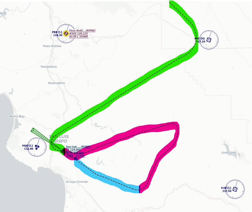
I just flew this route, slightly different but destination and landing runway was the same. ATC initially assigned me RNAV approach via one of the transitions, but I request vectors to final.
Below is the approach flight path. Green is my own navigation, red is vectoring by ATC, blue is when ATC switched me to tower and vectoring stopped. Too early for my liking but after I asked for airport direction tower said it’s on my 3 o’clock so I turned 90deg to the right and got to the final fix point. The minimum flight level during vectoring was 3900ft, assigned by ATC. I was not in danger of hitting a mountain in any part of the approach.
So that’s it then? I am wrong, because I’ve gotten the sense that is what you set out to prove to me.
I’m not sure why this is/was necessary.
I do not experience a failure on the part of ATC with 100% certainty. I’ve even been vectored to KSBP with success in previous flights. However I absolutely do experience this issue of vectors and altitudes placing me in harm’s way.
Your flight approached KSBP from a different location, and even when you requested your vectors would have been at a different place and point in your flight path than mine.
I don’t know. You tell me. If you didn’t want to have any discussion why did you start this topic in “General Discussion”? You should show your picture in a Screenshots section or something.
This topic is full of people “joking” how useless ATC is and everyone gets vectored to the side of a mountain or something. I hope my post will shut them up but who I am kidding. In a few days someone else will start a similar topic.
This statement is an indication of the finality of your belief that these work 100%.
I’m fine with a general discussion. I don’t want your one success at this specific airport to represent that vectors work 100% as designed, because I know I have had multiple flights where it has not, including the one in the OP.
I wouldn’t be here to discuss it, if this were not the case.
ATC in the sim is awful.
Best of luck to all, if we need to comply with ATC instructions to advance in the new career mode.
IRL, MSAs were one of the banes of my life as a dispatcher - often ATC would clear a flight to descend below an MSA. We would always brief operating flight crews on the risks of terrain and the relevant MSAs so they would know not to descend into a CFIT, even if ATC cleared them. In the sim I’m not sure whether the terrain height is known to the ATC engine - if it is, you would have thought it would be easy to make sure that the clearances gave adequate terrain clearance - but when you get MSFS ATC often trying to keep you up to 20k ft until within 10 miles of an IAP , the best thing to do is ignore it altogether. For me that goes for vectors too… personally I find it best to take control of the navigation myself.
Rather then spending loads of effort introducing a career mode, it would have made for a much better experience if ATC was fixed properly.