Thanks, I’ll check once I’ve got time for that ![]()
1 Like
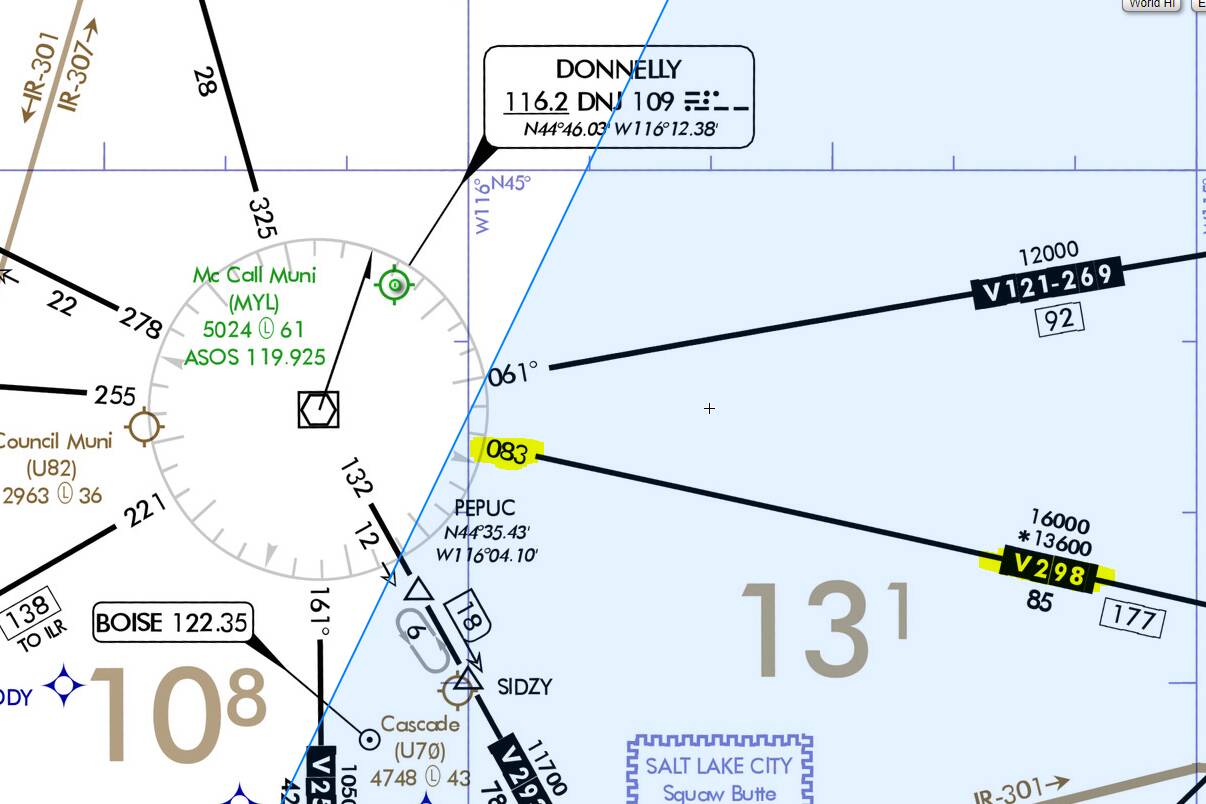
As usual, I first thought I’d have it understood and then I find DNJ VOR which gives me headaches.
So the charts and the VOR rose in LNM both agree that V298 is outbound radial 083°:
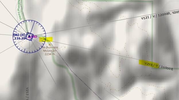
Now if I create a flight plan, it either shows me 87° (if I disable ignoring of the declination):
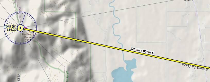
Or if I enable the ignoring of the declination, it shows 89°:
When doing a measurement between the VORs, I get the 083° that matches the radial:

I’m confused, to say the least ![]()
So could it be that the measure distance tool shows the radials when starting the measurement from a VOR?
Excellent example! 
This illustrates nicely what I was referring to before, that outbound radials of one VOR could be significantly different to the reciprocal inbound radial of the other VOR.
I think the key here lies in looking at the other VOR endpoint for this airway - DBS (Dubois), where the outbound radial for this airway is defined as 270 (and not 263 as you would expect, so a full 7 degree difference!). Now if you look at the ‘measure distance’ tool in LNM it actually doesn’t give you just one, but two headings - 83M → 91M. My guess is that it shows you the calculated heading (including VOR variation) for one end (which here seems to be exact), and for the other end (which is only 1 degree off).
So I bet if you would add a waypoint right on that airway close to DNJ, LNM will show you 83 for this short leg, and if you add a waypoint close to DBS, it will show you 91…
Have to try that out ![]()
The other end of the measure distance tool doesn’t stick to the VOR, you just place it somewhere in the map.
So while I think it gives you the corrected outbound radial (since starting measurement is locked to the navaid) the destination VOR doesn’t matter for the display of the measure tool.
But measuring them from both sides should give the result for each of them as you said ![]()
I simply use VOR as a way to add an additional challenge to the bush trips in addition to using the VFR techniques. Keeps me enticed a little longer.
You can set it out yourself. Install LittleNavmap. Plan your flight from airport via VORDME to another airport.
I wouldnt export the flightplan to MS. Instead save it in NavMap and print the flight plan (you probably only need to print the first summary page, page 1). It will give you all the frequencies. If you open LittleNapmap also it will show you all the radials.
Lots of fun and wont have to contend with the MS flight planner.
Make sure you are switched to VOR.
Real flying rather than being a bus driver. It is a lot of fun and you keep busy
Thanks for this, I installed LittleNavmap and found this to be great fun! Along with Neofly I have a 2nd wind with the sim.
Ospi2751; it enables real flying as you are constantly busy. LittleNavMap also shows the VORTAC transmitters that you can include in your plan also as VOR/DME as you probably know.
I use it all the time and never fly liners. To me that is like watching a video. Nothing to do except take off and land.
Flying a flightplan you have setout in Little NavMap and you follow having printed it out, having to set your bearings and headings, engages you all the time while in flight. Calculating descent speed and distance start (easy using the little 3* and 5* trick) its all part of piloting a plane.
Its using the Simulator as a Simulator rather as a game and engages with the real World navigation beacons. Thus MSFS caters for all needs.
It also of course avoids using the Simulator Flight Planner. But make sure you are switched to NAV not GPS.
Have fun.
This topic was automatically closed 30 days after the last reply. New replies are no longer allowed.