Are there any decent bush trips designed with VOR flying in mind where the in-game nav list will give you radials and frequencies as you go through your trip? I enjoy the added workload of flying VOR and the increased sense of achievement with completing trips using it so would love some bush trips dedicated to it.
I never used the in-game nav list but I doubt it will give you radials, I suspect only magnetic headings. So that’s one thing you have to bear in mind…
In the end it’s just text that is provided with the bush trip leg descriptions, I don’t see any reason not to be able to provide VOR information instead of headings.
Not sure if watching VOR needles hits the purpose of bush trips though (especially since they are usually flown in areas where VORs might be rare), but technically it should be possible.
You should give it a try, it’s fun if the sim doesn’t forget your last finished leg
Getting to fly in areas you’d otherwise might never do and navigating by simple duration/distance and some visual guidance is pretty interesting and you get to enjoy the view much more than watching instruments.
But back to topic:
Basically any VOR-to-VOR route that you can create with LittleNavMap will result in a flight plan containing the radials, so you basically create one yourself - without the background information and sightseeing hints that a bushtrip comes with though
In much earlier days in the 1980’s when scenery was truly less than optimal (we dreamt of having a sim like the one we have now) there were books which took you on guided flights using VORs and radials. With modern GPS, I haven’t used them for years. I make bush trips so will look out my old books from the attic and perhaps give this a go. We really need Asobo to fix the damage they have done to bush trip flying since SU5 first though…
Oh yeah I can totally see that, it’s just I’m so hooked on the DC-6 that bush trips aren’t really an option
But back to topic:
Actually that’s not entirely the case - LNM only gives you magnetic headings in its flight plan (I’m planning all my VOR-VOR DC-6 flights with LNM), so you have to adjust for the current magnetic variation of the VOR, which is often difficult to find out. Unless you are flying airways of course, where you can get the exact radials on the IFR map (e.g. Navigraph, Skyvector)
Little Navmap uses the declination of a VOR to calculate the inbound and outbound magnetic course of a flight plan leg to and from this VOR. This allows the pilot to use the VOR radials for navigation. For all other legs the actual environment declination is used.
And you can check if you have the setting disabled (which is default) in the settings to have the magnetic declination included in the values:
You can disable the use of VOR declination in the options dialog on page Flight Plan by checking Ignore declination of VOR and other radio navaids . This will use the environment declination for all calculations. You might want to use this if you fly entirely based on GPS and ignore VOR stations.
So basically you should be good using the magnetic course values in your flight plan if you have this setting disabled.
A bit confusing since you have to disable the option to enable the declination correction
I use it all the time when navigating VORs and it works a charm.
You can enable the WebServer in the “Tools” menu and then navigate from a mobile device to the URL to get the flight plan on your lap, including the VOR radials shown in the “Course °M” column. Pretty convenient.
Sorry for off topic But maybe useful information nonetheless.
I also apologize in advance for remaining off-topic (and I promise it’ll be the last), though the OP’s post is also about VORs so it has at least some relevance
Yeah I know about this setting, and I indeed have it disabled. The problem I found is that the VOR declination value LNM factors in (from MSFS data) is not necessarily the declination that is currently in effect. When you compare the magnetic headings that LNM provides with many of the VOR radials that define airways (as published on the IFR maps), it is usually off by at least one degree, though I’ve often seen even a difference of 2 or 3 degrees.
Having said that, you are right and you should usually be good using the magnetic heading LNM provides, especially when simply navigating VOR to VOR. It really only matters if you are flying airways and you want to stay exactly on the airway, or if you use something like Pilot2ATC which expects you to follow the filed flight plan within your set limits. If the leg between two VORs is long an error of one or two degrees can make a big difference (though in this case I just wait until P2A yells at me that I’m off-course and switch over to the next nearest radial )
You’re right if you’re using two or more sources for navigation.
As long as you stay in LNM to get your airways and courses, you should be good since it’s consistent. LNM will show you airways and their magnetic course including the declination of the according VORs exactly the way you’d need to fly them to not run into issues.
Using MSFS VORs but navigating using charts might end up being wrong if they have a different declination, BUT you don’t have to factor in the declination on top but instead only the difference of the declination that is shown in LNM (MSFS data) versus the declination of the VOR based on your charts.
That being said, as long as you import the MSFS data after every update (and every addon scenery you install), using LNM should give you all the precise data you need in the sim.
Do you have an example of a VOR that is wrong in MSFS? I’d like to check the details.
(maybe I should ask a mod to move our discussion into a dedicated new thread I find these details pretty interesting)
Hmm, I don’t think it really matters whether you stay within LNM or not. The problem here is that the location of the VORs is the same in LNM, MSFS, IFR charts, real world etc. And the VOR radials that define airways are fixed and almost never change - they have been set when the VOR got built and calibrated based on the magnetic declination in that location at that time. Now even if you stay within LNM, it can only calculate the magnetic course (and adjust based on variation) between those VORs based on the published VOR variation value that it has available from MSFS, which seems most often to not be entirely correct (and is sometimes blatantly wrong, as you can see in this old post where I started to get an understanding of all this). All three factors need to be known - the current magnetic declination at that location, the magnetic declination that was used when the VOR was calibrated, and the time the VOR was calibrated. So naturally those magnetic headings that LNM will give you aren’t precise (for the purpose of exactly following the airway). But again, in the grand scheme of things this is probably not a big deal
Fwiw I found that even when using Navigraph data for both MSFS and LNM (that’s what I do) the differences are still there, so even Navigraph does not seem to supply the exact right data all the time
Sure, if I find time tonight I will give you a few examples.
One more thing - LNM only gives you one heading for each VOR-VOR leg in your flight plan. But is often the case that the outbound VOR radial that defines an airway is not the same as the inbound radial of the other VOR (e.g. outbound of VOR 1 might be 180 degrees but inbound of the other VOR might be 002 degrees). So even though you can correctly fly the first part of that leg on the airway using LNM’s magnetic heading (assuming it’s more or less correct), when you switch over to VOR 2 and dial in the reciprocal heading you’ll be off. One way to ‘fix’ this is to put another waypoint in the middle of the leg in LNM (something that I learned from a suggestion in that other post)
I do find these details very interesting too, and enjoy this conversation . But you are right, we should see if the the OP @Ospi2751 minds this bit off-topic discussion in his thread, then we can either move on to a new thread or continue via PM if needed.
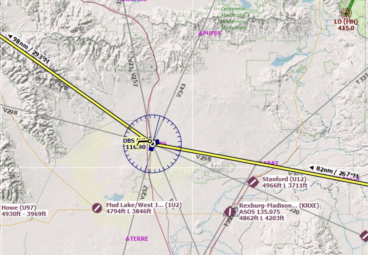
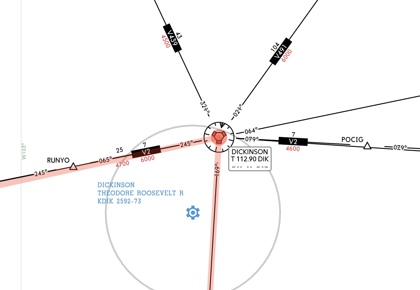
So I just created a random route in the US Midwest following airways, and didn’t have to search long to find a few VORs that stand out. Right now I use Navigraph data for both MSFS and LNM, but I’m pretty sure it will be the same (or similar) when using MSFS stock data only (I may uninstall my Navigraph data and check this if I find some time). Here are just two examples:
So if you dial in the 293 from LNM into your CDI to follow V520, you will definitely be off course very soon. Note that both Navigraph and LNM show a VOR variation of 15 degrees. If you google more details about this VOR, you find that the VOR was calibrated with this 15 degree variation in 1990
Interesting reading in here, learned a few things so appreciate that. For now I am creating my own little trips using Skyvector and going from there, which I’m fine with as you lean a little more than when the sim spits out everything automated for you.
True, but I understand that having someone created a scenic route, providing you all the navigation details and text for some waypoints with background information or just random facts has its appeal.
Like a guided tour but with you having to navigate through it.