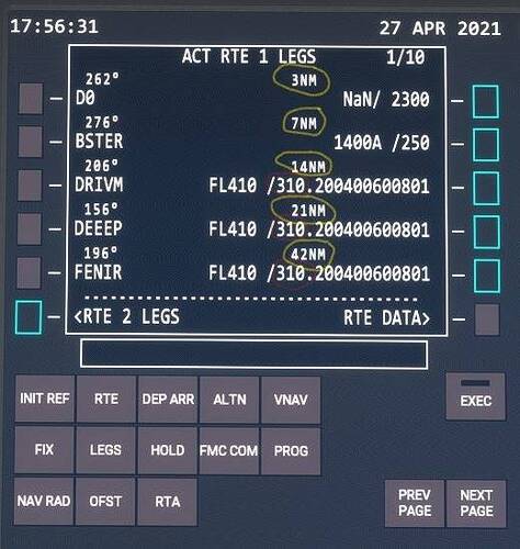
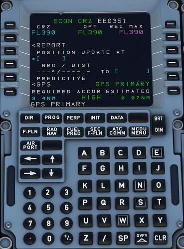
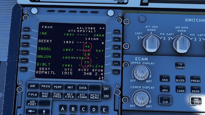
Can someone tell me where to see the distances for all of my waypoints in the A320Neo MCDU? With the Boeing FMC this is very easy. You Simply click on the “LEGS” page, and you’re good to go (see screenshot below). But on the Airbus, it isn’t so straight forward. The PROG (progress) Page doesn’t help (see screenshot below). So I tried the F-PLN (flightplan) Page (see screenshot below). I’ve circled in red what I think are the waypoint distances. Can anyone confirm? And if so, why don’t they show on every route that I fly? Most of the time, these numbers don’t appear. To be honest, I don’t know how they came up in the attached screenshot. Lastly, why isn’t the SPD (speed) shown for each leg? As you can see in the screenshot, it only shows three dashes under the SPD column. Thanks in advance for your help. Regards, Jaime
Is that on the Default Asobo A320 or the FBW A32NX?
On the FBW.
Dev version?
How can I tell?
Well, when you install the FBW A32NX mod, you should be given a choice using the installer. Install the Stable version or the Development version.
Oh wait, it its the Stable version.
Try to switch to the development version… See if that makes a difference.
Ok, but I am looking in the right place in the MCDU? Is it the F-PLN page that I should be looking in?
Yeah… I dunno if it’s showing in the dev version though… I never really look into distances to my next waypoint. As long as I’m on track and know how long in terms of “time” to my final destination. I’m pretty happy with it… I never really cared about distance.
Ok, so you don’t know.
And now we know why you are having troubles with the level restrictions during the descent ![]()
Yes you are looking at the right MCDU page and the numbers you circled in red are the distances. I am not in front of my PC, but last time I checked the FBW stable version did put out the correct values adding up to the total displayed distance at the bottom in white. (DIST 1006nm in your example)… welcome to Miami. 
@TripwireBX , You had the distances circled correctly in your screenshot of the stock A320. I’d highly recommend you get the Development version of the A32NX from Fly By Wire. They have an installer app on their GitHub site which will install the right version. You can change to any other version from the app just by clicking a button.
With the Developer version, Here is how the accurate distances appear on the MCDU:
You can see that my current TO waypoint is GEEKY with 141NM remaining. The next waypoint is SNGGL with 46NM between the two.
Kinda off topic but what’s up with the altitude constraints. Like where you have waypoint SNGGL it says 567. Is that just showing that’s the maximum FL for that waypoint? Kinda high lol. And is there any kind of vnav that works yet by setting constraints and following them on descent? I know they were working on it but haven’t flown the FBW in a while. I’ve just been calculating my decent and engaging a -3 degree to decent and adjusting as necessary. Hope they get the TOD implemented soon.
True and accurate VNAV in all versions of the A32NX is under development. It only partially works. As for restrictions, the normal MCDU would either show a restriction or a predicted crossing altitude in some cases. I presume that’s what this is showing although it isn’t fully implemented to be correct.
This topic was automatically closed 30 days after the last reply. New replies are no longer allowed.


