I can’t confirm, but after the tests you have done it seems like it’s happening every hour. Well, if it’s happening every hour then it’s even easier to confirm
I’ve only marked 07:00Z as a time when i have actually seen the switch and noted the time.
I play a lot the sim, and yes the switch or hard transition happens very frequently but, the transition from pre su7 clouds to the generic ones I only see it once a day early morning?!
If you look towards the horizon, there are clouds that I’d tick as a pre-SU7 clouds. They are more stratiform and generally better looking. Then they changed to cumulus.
I’m on my way to work pretty early every day at the moment - I’d also like to test it - but I can’t until Thursday - I’ve already noticed it, but I didn’t really notice the “time” of this shift. But at the very least, the topic should be “feedback-logged” and exactly “bug logged” - I don’t understand why this is not noticed above.
I am already convinced that the processing or the first input of the weather probably happens as before SU7 on the basis of the MeteoBlue forecast (or whatever) and then possibly an “interpolation” of the data happens on the basis of METAR (wherever this data should come from). And since the METAR in terms of “representation” (if no additional data are used) can only represent “simple” or predefined cloud data (OVC, BKN, SCT, FEW and so on) and is therefore at least not really useful since here you can only use a “preset” and it shows again, that the use of the PURE METAR data for the representation in a SIM is not really usable (and as I said without a lot of the additional data) and can only happen “in a generic way” (explain this since there are METAR “based” engines, hope now is better understood by some resp. you can clearly see the difference here.)
true, so maybe every update is good then it switch to generic? hard to tell but definitively looks like a bug. Asobo needs to see this as soon as possible, perhaps it’s a server issue or software side, it’s really hard for us to tell where the problem lies…only the developer can pin point it once the know!
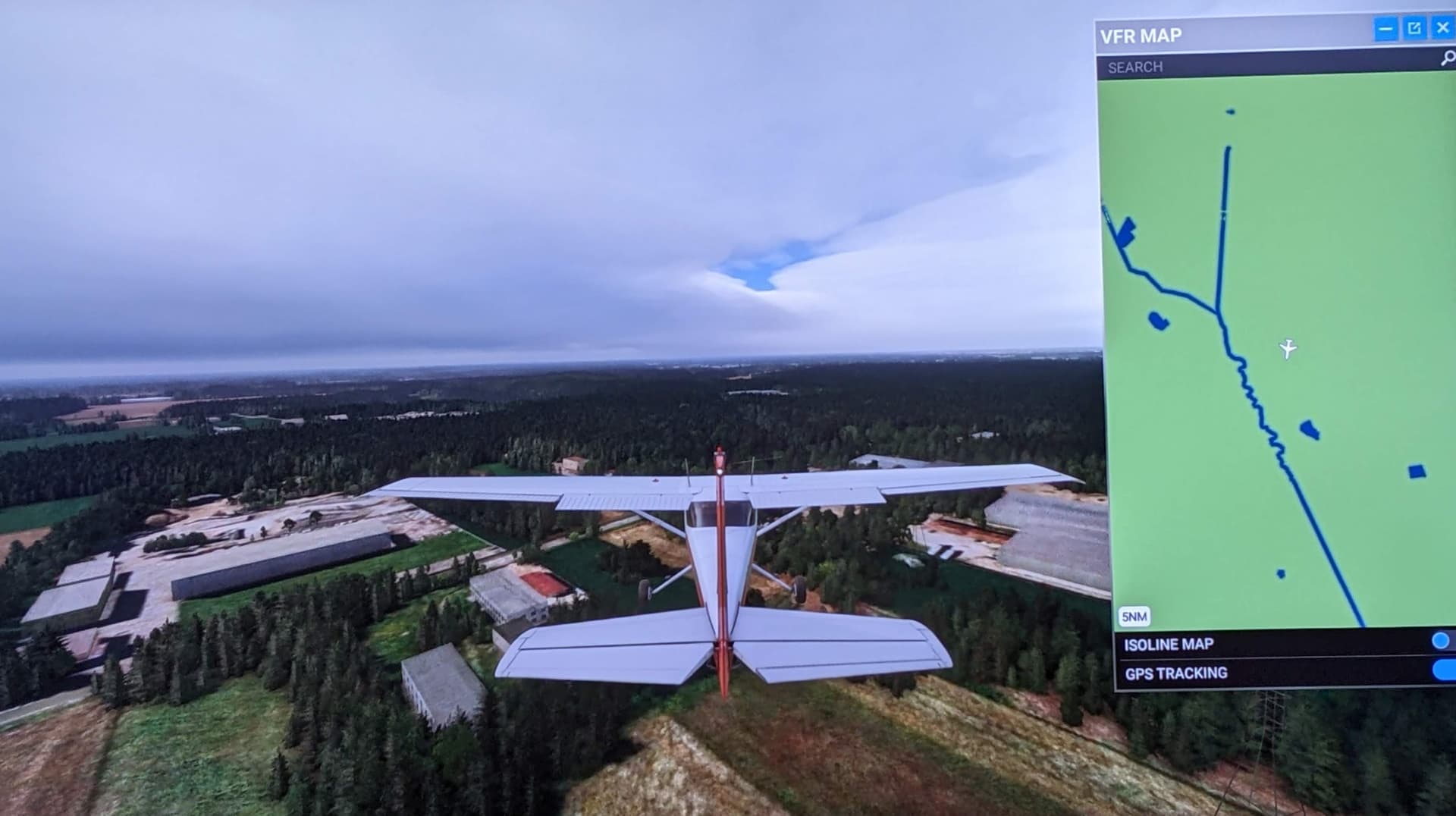
Did a few more tests. I started at around 6:45 Zulu at EDJA and started moving around in weather using slew mode.
What I saw was some beautiful overcast…
Climbing up I saw double layer cloud front with connecting cumulus towers. While this might not be very natural looking, I remember seeing this often pre SU7, when weather was still multi-layered.
Whats interesting: EDJAs METAR still reported Overcast. The sim drew a circular pattern around the airport with respectable looking overcast (of course made up of cb clouds). However, the cloud base and percipitation changed and jumped every half hour exactly on time with the automatic METAR updates, while the Meteoblue forecast model predicted no relevant change during that time. So what the Devs said about METAR not having an influence on clouds at all is pretty much bull in my eyes.
EDIT: Removed pictures name with timestamp to avoid confusion, as the time shown was that of me cropping the pictures and saving as copies, not their time of creation.
It’s all looking pretty conclusive, isn’t it. At least as far as it happening, if not the reason why. Hopefully Asobo scrutinise this thread, and find out the why.
What confuses me is that I cant even replicate the horrible current look of clouds with presets or similar. While most of the pre SU7 cloudscapes could be recreated with the weather tool ingame (at least locally) I am absolutely unable to create anything that looks as bad as this puffy, all transparent mess we see all the time.
Wow - those first 2 pictures are how I remember things when the sim first launched. Good work! I really hope we can get this escalated to the powers that be. Would be great to have that back permanently.
It’s like two completely different weather engines in use. The first is complex/advanced the second is simple/basic. Feels like the socond weather system it switches to is some kind of placeholder. I bet it’s used to increase performance or something but i can’t feel any difference in performance in neither of those. The only feel i get is that it switches without purpose.
Well, that is of course a question or a guess, but I have also thought of something similar - perhaps the evaluation of the load has shown that the most server load happens during this time ? (or from this point on) , so they switch to something “simple” to improve the performance in the meantime or the preparation is very complex and they decide to use something generic, more or less, in order to save server resources ! Whatever, but to be honest - without “blaming” anyone of course - I don’t think, after all the threads and “complaints” about the weather (since SU7) that these “errors” and “processes” on the part of Asobo or MS are not known - or different approaches are used for testing - but I think as always - they could admit that openly, it is also good if they try different approaches to satisfy the customers. But to the question “what is different in the Weather Engine now?” the answer should not be “actually we haven’t changed much there”!
I don’t think it is done with any bad intent. A you said, there is no noticeable difference in performance.
In my eyes it seems like a stark misinterpretation problem of the provided data. If you are familiar with meteoblues forecast, they provide local approximation of cloud coverage with base height, thickness, and most importantly density, similar to this:
The cloud thickness and height seem to be mostly correct in the sim, but for some reason it appears that density or scattering is not.
Apperently no realistics clouds are drawn anymore, but the sim tries to approximate the forecast by placing multiple layers of almost transparent puffs into and ontop of each other until it arrives at the reported densities. At least that what the current system looks like.
What I don’t understand is that following all your observations, the weather system is able to correct for this given time (?), but is reset into madness once new data arrives. However, I can’t imagine that the system is or was really that advanced, that formation of stratiform clouds was modelled just by itself.
All this is exactly opposite to what I would expect from Meteoblue data. I would expect the clouds to be precisely estimated in their size and scatterage at the BEGINNING of a forecast and getting progressively worse and statistically noisy towards the end. But it seems it’s the other way around here?
We should try to recreate this bug in areas without any METAR reports nearby, to see how much of this problem is created by METAR interference.
Well, at some point they ultimately do improve within a 24hr period. If they didn’t it would be like photocopying the same document over, and over again.
Well i have created a timelapse of the weather without METAR interfare but i couldn’t record it with real time. I needed to change time because it were night there. I will make a new one. to not make us confused here with the time stamps but it takes real hours to create timelapses.
My observations during that timelapse is that weather seems more detailed right before the switch. After each switch i could see some difference in the clouds. It also feels like i can’t get overcast above me because as soon as it starts to get overcast it switches to almost clear sky even if i predicted a cloud front moving over.
Here is the time-lapse but this can’t be used to confirm issues with times because of the custom-time i used.
My thoughts is that we requested more accurate weather and got more frequent updates in weather data from Meteoblue as well besides METAR 12hours became 6hours. I think the weather is dynamically simulated over time but then a new updated stream arrives and the weather simulation starts over again with some small changes in that forecasted data. I also noticed there is less frequent updates outside of METAR zones. That was expected right?