Hi there, What does the term “RNAV” Mean? Any help is greatly appreciated. Thanks in advance.
RNAV means Area navigation.
a quick google search will yield a lot of great info, more than we can ever type here in a single post.
Here’s one of the first results:
2 Likes
Thanks for the reply and help..
No problem at all. Happy to be of assistance.
1 Like
Area navigation (RNAV, usually pronounced as /ˈɑːrnæv/ "ar-nav") is a method of instrument flight rules (IFR) navigation that allows an aircraft to choose any course within a network of navigation beacons, rather than navigate directly to and from the beacons. This can conserve flight distance, reduce congestion, and allow flights into airports without beacons. Area navigation used to be called “random navigation”, hence the acronym RNAV.[1]
RNAV can be defined as a method of navigation that permits aircraft operation on any desired course within the coverage of station-referenced navigation signals or within the limits of a self-contained system capability, or a combination of these.
In the United States, RNAV was developed in the 1960s, and the first such routes were published in the 1970s. In January 1983, the Federal Aviation Administration revoked all RNAV routes in the contiguous United States due to findings that aircraft were using inertial navigation systems rather than the ground-based beacons, and so cost–benefit analysis was not in favour of maintaining the RNAV routes system.[2] RNAV was reintroduced after the large-scale introduction of satellite navigation.
Thisabove is from Wiki…
Though I always thought RNAV stood for Radio Navigation…
Add images
enjoy ![]()

2 Likes
Great link! Thanks for posting it.
I guess in simpler terms. RNAV is an approach type that uses absolute GPS coordinates to trace a flight path to the runway, rather than using ground-based beacons.
So basically, the path is established, and the aircraft will fly to follow that path by comparing their GPS location and the location path from the RNAV. And it flies by keeping track of their GPS positions all the time and match it to the flight path.
The RNAV path itself tends to be accurate, but actually flying it is anything but. That’s because the GPS has a certain level of accuracy that it can operates. There’s always a margin of a few metres apart depending on how accurate the GPS in the aircraft is, and how many GPS satellite are able to pinpoint the aircraft’s locations. The more GPS satellites the aircraft communicates, the more accurate their GPS position would be, and the closer it is to follow the RNAV approach. But if there’s not many GPS satellite tracking the aircraft position, it may be reporting an inaccurate GPS positions, so it may trace the RNAV path with a little bit of deviation.
Does a RNAV approach include the glideslope like ILS?
No. It will either guide you towards establishing on a classic ILS, or will provide a step-by-step or “step-down” path(*) with intermediate points and altitudes until you get visual contact.
(*) check this chart for clarity: https://www.researchgate.net/figure/Example-of-RNAV-approach-with-RF-legs-Source-USA-AIP_fig6_39680363
Depends on the RNAV type. some do, but most of them don’t. For me, I just use the charts to tell me the descent profile. Usually it shows, which waypoint to look for and at which altitude, then it shows the descent angle path from that waypoint down to the runway.
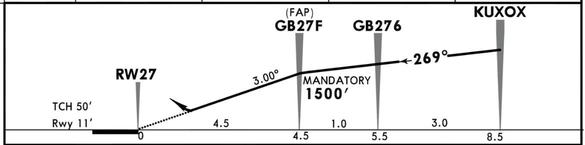
Then I use the FPA mode to descent not using V/S or calculated by the flight computers. But just by selecting the descent angle. The Example below is for Gibraltar RNAV RWY 27. You should be tracking 269 degrees direction from KUXOX to GB27F. At the GB27F you have to be at 1,500 feet. Once you reach it, you set to descent down to the runway elevation altitude with a 3 degree angle. And the aircraft will do all the necessary calculation to make sure you’re descending at 3 degree angle from that point down to the runway. It doesn’t do it automatically, you have to set the descent rate yourself based on these charts.
Sorry this is incorrect. There is no glideslope in any RNAV approach as it is a non-precision approach. Advanced aircraft navigational systems can compliment an RNAV approach with vertical guidance (VNAV or VDEV) but this is not part of the approach itself.
RNAV GPS approaches with WAAS can be certified up to ILS minimums but these to be flown require the aircraft to have the related certified avionics.
That was exactly what I was referring to, the Vertical guidance. But as I said, it doesn’t always work even on the same aircraft with the same avionics. At least, not in MSFS at least. I have done some RNAV approaches where hitting the FINAL APP mode will make my A320 to descend down to the runway on its own after passing the waypoint specified in the charts. But other times, to other airport it doesn’t do it. So I had to rely on the FPA descent instead. Overtime, I find the Final App mode to be hit or miss. So I just skip it altogether now and just use my trusted FPA.
1 Like
IRL all the equipment used in MSFS is certified. This doesn’t mean that MSFS is using the GPS with WAAS. Probably a good question for the developers. I recall flying an RNAV approach using LPV minimums but never acquired a glideslope. I used LNAV minimums instead. I don’t recall which aircraft/GPS I was using…
My answer was more about the RL theory, not specifically for the sim.
Sadly MSFS simulates the G1000 and not the NXi which provides vertical guidance.
This topic was automatically closed 30 days after the last reply. New replies are no longer allowed.