I assume the GPS in the Sim does not actually simulate connecting to a virtual satellite network and measure time and distance and calculate actual position, so where does the GPS get its position and direction information from? is it connected to the aircraft location in the software ie the Sim “knows” where the aircraft is or is it an independent calculation?
The reason I ask is that the flying the A2A Comanche the compass card heading appears to change the heading on the GPS although in “theory” the GPS and the aircraft have no connection
![]()
Moved to User Support Hub as the OP is requesting community assistance.
I don’t have the Comanche but I suspect that it and all glass aircraft behave the same. The steam HSI, compass, backup HSI and GPS HSI all get their data from similar sources - some sort of magnetic field sensor. Thus all should display the same readings if all are working perfectly and are properly calibrated.
Hi, I was really asking if Microsoft/Asobo/WT actually have a model for GPS systems or if it just takes Data from the Lat /long heading etc of the aircraft and just displays it on the GPS
I noticed that the A2A aircraft heading differed from the GPS heading which caused me to question what the really GPS shows.
It is more a programming question than a user support question and really only a question of interest rather than a bug or support issue. I have heard on other forums that MSFS does or doesn’t simulate some form of actual GPS functionality and really wanted to know which was correct from the “horses mouth” ![]()
Now you’re confusing me. Your original post read like you noticed that the HSI and GPS headings were the same (" the compass card heading appears to change the heading on the GPS although in “theory” the GPS and the aircraft have no connection") and this caused you to question where the data came from, hence my post above.
Now in your latest post you say " the A2A aircraft heading differed from the GPS heading".
Hope you find whatever answers you’re looking for…
I really want to know what data the sim represents on the GPS?
The issue with A2As aircraft is immaterial,they say that the heading on the GPS is taken from the heading data in the aircraft and therefore if the heading data is wrong on the aircraft the GPS shows the wrong heading as well.
In real life a hand held GPS is independent of the aircraft and will track its heading without reference to any aircraft instrument settings
The answer i am looking for is does MSFS model the GPS independently, it would be a yes or no answer
MSFS has a pretty deep GPS simulation including GPS ephemeris and individual satellite tracking.
However, the GNS430/530 in MSFS has a few bugs on its own. One bug is that the map in “track up” mode actually shows “heading up”, which is not the same thing. The other issue is that the GNS unit has heading source at all.
In real life GPS by itself does not determine aircraft heading. It knows the aircraft position and can derive aircraft ground track from position changes over time, but only if the vehicle is moving. Aircraft mounted GPS units often have the ability to connect external heading source from other aircraft avionics. But this is not something found very often in simple GA planes as it requires a digital source of heading information in the first place. Which a simple mechanical gyro does not provide.
This is not a problem unique to A2A Comanche, the stock Cessna 172 shows the same issues. Only difference is that in stock aircraft the heading gyro is always aligned on startup, so you don’t see it drift so often.
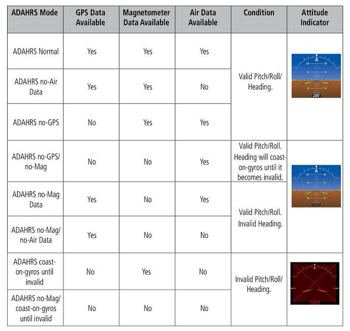
The G1000 has an integrated Attitude Heading Reference System (AHRS), which uses MEMS accelerometers, tilt, and rate sensors, along with a magnetometer to provide attitude info. Alongside that is an air data computer (ADC) that provides pitot/static and OAT. This is all combined into an ADAHRS. It also uses two GPS receivers for position information and has a number of reversion modes. Basically, if you lose the magnetometer and still have GPS, it will give you track, but heading will be invalid.
Here’s how the reversion modes work in the G1000NXi, straight from the manual:
The GNS system is not integrated like that, and will not provide heading information to an analog HSI or vice versa. There are some nav gauges that will send and accept course data so you don’t have to dial the course in (and will also help select the course in OBS mode).
After all of that, I’m not 100% sure how the sim integrates these - whether it’s truly emulating the interdependent functionality or if it’s pushing more than it does in real life.
My understanding is that some of LRUs in the sim’s G1000 are not being properly powered by the various electrical buses, which is why we’re getting the gray dot instead of the aircraft icon.
Can you explain or at least point an interested observer to documentation that explains how that satellite ephemeris data is exposed for avionics to use? Or is it a black-box simulation that only shows the results inside one of the WT Garmin units?
You can find GPSEphemeris and other GPS interfaces here:
You can also start poking into the typescript files mentioned there, that are part of WT avionics framework.
