Oh man I love those movies!!
@Boobbuster007 , exactly as @Boufogre described it. The fuel required bit comes from planning the route. The “old school”, yet still effective way of doing this is VFR:
- Break out your sectional(s) and plot your route by drawing a course line to each checkpoint
- Use your flight ruler/plotter to measure the distance between each leg. Remember, if this is VFR, keep your distances between each checkpoint reasonable. This also gives you a better opportunity to correct for any wind compensation needed due to actual winds you encounter en-route
- Calculate your course for each leg using your plotter - That’ll be important to steer to the checkpoint. Course will be your track across the ground considering the wind.
- Check the weather by getting a briefing for the area of planned flight, paying particular attention to the winds at your planned cruise altitude. More headwind = higher fuel burn. Is your altitude favorable?
- Now that you know the winds at cruise you can determine how much head/tailwind you’ll have and the impact that’ll have on course and with some calculations, you’ll get the calibrated HEADING to fly.
- Knowing the winds, true airspeed (I use 114kts true for the 172 but you can calculate this), distance to fly and your groundspeed, you can calculate estimated time enroute to each checkpoint.
- Referring to your POH you will get all the data you need to calculate fuel burn from start up (I typically use 1.1 gal for start and taxi in the 172), climb, and cruise with the appropriate power settings. You’ll get your gallon per hour fuel burn. Add all of this up and you get total distances, time and fuel burn estimates which you can check and enter actuals along the way.
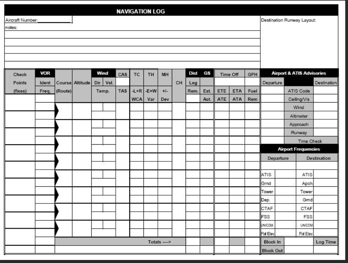
Here’s a sample Navigation Log you would use for this - Funny, it’s the exact one I used to use when planning my VFR flights during my initial flight training. I now use the electronic version of this with ForeFlight on an iPad. Same thing, just more information available for deep planning and execution. Good luck!
@Boobbuster007 , For flight planning, You’ll want to focus on section 5, performance and section 6, weight and balance in the Bonanza POH you posted. You’ll get all the data you need to plan appropriate fuel burns. Know that if you are just learning, you’re somewhat heading into deeper waters to start with the Bonanza which is classified as a Complex, High Performance single engine plane where here in the states requires an endorsement to fly.
Not that you can’t - It’s sim world - do what you want! It’s just that there are a few more variables that will be super important to know since you have an airplane with an constant speed (adjustable pitch) prop and retractable landing gear and higher cruise speeds. Nothing to stop you, just that it’ll be more complicated than a simple aircraft like a 172 when you get into the numbers.
1 Like
There are more things to think about, adjust, use, and diagnose during flight, but during flight planning it doesn’t change much. You still need to select a power regime, which then gives you a fuel flow.
1 Like
You should have instead quoted this from my response. That was the reference to his POH where he will use the Performance data to calculate fuel, full stop.
The next section was simply offering input on the additional complexities of the chosen tool for the job as a new pilot. Clearly planning is the same, don’t confuse the two.
1 Like
Well, i didn’t quote that cause i fully agreed with it ![]()
LOL, nice..gotcha
Ha love how they used MSFS for the animations ![]()
1 Like
Yes, was X-plane before, MSFS just kills it on the graphics front.
2 Likes
Thank you so much everyone for your efforts putting into this thread.
It is so much appreciated, thanks you!
Thank you @Fmgc320 for the step by step guide!
As an addition to your guide I found this on the internet.
The part I struggle the most with is understanding with variables to use in the calculations. For example, magnetic vs true heading vs calibrated heading. True airspeed vs indicated. Pressure altitude vs density altitude, to name a few. There is so much to digest and for me I think to understand all of this better is to start reading a book. Make notes along the way and evaluate now and then.
At the moment I scavenge the internet every so often for information but I find it a bit overwhelming.
Therefor reading a book I hope teaches me al the fundamentals of flight in an order that makes sense to me.
Challenge is, what book?
A pilot’s handbook of aeronautical knowledge @EvidencePlz brought to light could be a step in the right direction.
Eventually I will understand this more, but I have to take my time and do it step by step.
—————
This is what I did today:
Last week I started with the series POI hunting UK, where I fly to every point of interest Asobo put on the map in the United Kingdom.
I started at London City and made my way east and tracked the coast south.
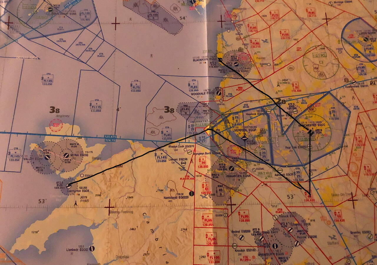
For todays leg I departed out of Caernarfon airport (EGCK) followed the coast towards Liverpool, from there changed my course towards Jodrell Bank observatory and made my way via Manchester to Blackpool (EGNH) ETE 0:57.
So I planned this route using my new chart, plotter and E6-B.
After I drew all the lines, I measured the distance and the true course or magnetic ![]() .
.
One thing to look out for though guys, use the right scale on the plotter😌.
During my 2nd leg I had struggles to locate the observatory. I checked my chart finding out I used the wrong scale, leaving me searching for something that wasn’t there. Luckily I had thought of a plan B, the MCT VOR. I dialed in the frequency and measured the observatory on the chart, now using the right scale, related to the VOR. This allowed me to find the POI. What a relief and happy at the same time. From there the continuation of the route was pretty easy.
the good pilot I am, cough, I foresaw this would happen and anticipated for this and left Caernarfon with 75% fuel load😅
At Blackpool I was treated with a magnificent sunset on short final.
Things I learned from this are:
- Use the right scale on the plotter!
- small green triangles on the chart are vfr reference points. The observatory for example.
Next step: figuring out true heading vs magnetic heading vs calibrated heading.
1 Like
While you don’t need to read all of them right now, book three of the Fly Better series is on the topic of navigation. I would recommend it, especially considering that the entire series is available for free online: http://www.flybetter.com.au
2 Likes
@Boobbuster007, yes this and the reference @CristiNeagu provided will get you well on your way. I’m not familiar with UK charts and what would be equivalent to a “Sectional” chart here in the U.S., but the chart image you shared looks like an IFR type chart we would use here. The major difference is scales which is what you noted. Our sectionals are scaled at 1:500,000 and our terminal or “TAC” charts are even more granular at 1:250,000. VFR charts will have more symbology depicting VFR landmarks, towers, features, towns, roads, etc. better for VFR pilotage.
1 Like
Geez! Not everything in the aviation world bears simulating then.
1 Like
Hi @Fmgc320
The chart I bought is the WAC type. You are right saying that the sectional chart is a bit better for VFR pilotage. The reason I went for this chart is that this covers the entire UK.
As I’m flying sim only this was the perfect choice rather than buying 5 bigger charts and that way spending more.
But I’m with you, preferably I would have go for that 2nd option.
Not sure though what my girlfriend would think the moment I go upstairs with heaps of sectional charts under my arm🤣
Not entirely sure what you mean by saying this.
If you mean that I skipped my fuel calculations of my flight yesterday, then I understand.
But as I said earlier, I will work my way towards that.
Now I know WHY it is so important to calculate fuel, my aim is to fully understand the knowledge that is needed to calculate those numbers, so I can fill out a navlog effortlessly.
But yeah it needs time.
The book of aeronautical knowledge will be shipped today👌🏼
True heading vs magnetic heading vs calibrated heading
True heading is in reference to the true north, where all the Earth’s meridians cross ie the north pole.
What you’re measuring on a chart is a true course, as you’re using the meridians as a reference.
However, in the plane you don’t have a true compass.
You have a magnetic compass that’s sensitive to the Earth’s magnetic field. If you were to follow heading north on your compass, would you arrive to the north pole? No, because the magnetic pole is not colocated with the north pole. A second reason would be that as you’re getting closer to the magnetic pole, the magnetic field of the earth dips toward the surface and its horizontal component (think of it as a vector) is only getting weaker and weaker as you approach the magnetic pole. There is a point where it is so weak that the compass will be useless in providing reliable guidance. That’s the so-called 6 micro tesla zone.
So if the true north and the magnetic north are not colocated and you’re reading one the chart and using another in the plane, how do you reconcile these two?
Well, the chart is also giving you another useful data, which is magnetic variation. This is the angular difference between the north pole direction and the magnetic pole direction. Now you can translate a true reference measurement made on the chart to a magnetic reference that will be used in the plane.
So adding magnetic variation to true heading will give you the magnetic heading to follow once in the plane.
However, that plane that’s housing your compass is a big metallic mass, full of electrical equipment that will generate their own small magnetic fields. They’re going to disturb your compass. So the compass is calibrated on the ground, with a known magnetic reference to measure the deviations created by the plane and its equipment and adjust it so that the difference between the two is minimal.
In a real plane, if you look at the compass, you should see a small piece of paper under the compass. It will give you the correction to be applied on your heading to follow the desired magnetic heading. You can also see as you switch on electrical equipment the compass change its direction because of the disturbances in the magnetic field.
So now, to fly you need to add that small angular correction to the magnetic heading that you’ve already gotten from the true heading. And that’s the heading you should fly to reach your destination.
I say here heading, but what you’re really measuring on a chart is a course, that is then corrected for the expected wind, giving you the heading to fly to follow the said course.
Hopefully that’s clear.
3 Likes
Just so you know, there’s https://vfrmap.com for the US, and https://skyvector.com for the entire world, though i’m not sure how good SkyVector is outside of the US. But i totally understand why you’d want paper charts.
1 Like
I just checked, Skyvector is useless for VFR flying in Europe. The airspace structure is oversimplified, it doesn’t show all CTRs, SRZs, doesn’t show obstacles and other hazards, low flying areas, bird sanctuaries, flight corridors and so on, and so on…
Just compare this:
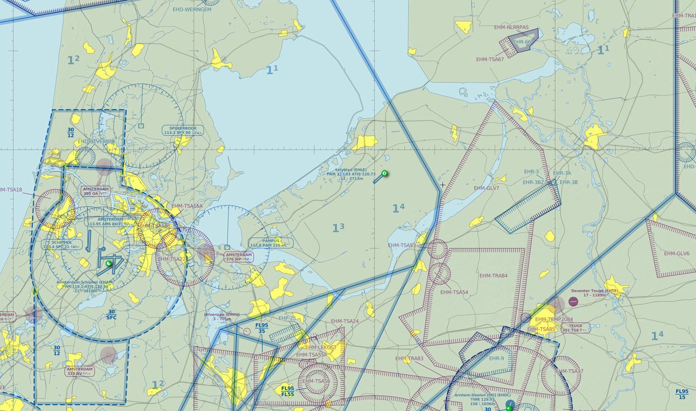
To this:

3 Likes
I had a feeling that would be the case… Thanks for checking.
Ah, sorry. I was merely referring to your unfortunate experience with the late luggage.
Regards.
1 Like
@Boobbuster007, makes sense. One things I used to do before I took on formal flight training was visit my local flight school and ask if they had any outdated charts. They gladly handed them over which works great for study and sim work. I think it’s every 56 days here in the States for new charts, maybe different in UK but I imagine what you could get won’t be that old. Just a tip you might try.
1 Like