When MSFS came out I was excited to do some bush flying in all sorts of crazy exotic places, making the most of the shiny new graphics when compared to XP, FSX etc. But a lot of those places just look… really, really bad in game. Arid/desert areas look okay, but pretty much all of the wetter mountain-y parts in most of South America, Africa and southern/eastern Asia are covered in splotchy low-res autogen textures, frequent jarring colour shifts, clouds etc.
I know this is a Bing Maps related issue and not an easy fix at all (just send a cheeky satellite up! simple!) hence why it’s mainly more remote and cloudy areas that are affected, and I know the whole data streaming system is a pretty incredible step up from needing several terabytes of medium-res ortho in order to make the game look good. But… given the sim is advertised as having the entire world to fly in, it kinda sucks to have so much of it looking so broken that it’s really only passable if you’re at FL400 and it’s cloudy and in the late afternoon. Even if the autogen textures were less awful/blended in better with the available imagery it would make a world of difference.
Have Asobo/MS ever addressed this issue? Has anyone seen any satellite imagery get better during the lifespan of the sim so far? I still run into some of the aforementioned imagery in world update areas too (Japan is particularly bad in the mountains).
Hi there, I will try to answer your question as best as I can. But before I do, in these green categories where you are supposed to tag with your platform, you are only supposed to use your platform’s tag, which in this case is ms-store. So I will be changing these tags on this post. It is always understood that these questions may apply to other platforms.
To answer your question:
In short, yes. I will answer first with a statement of fact, and then a statement of opinion.
Statement of fact:
It has been addressed in previous developer streams and Jörg Neumann, head of Microsoft Flight Simulator, has announced plans to go around the world and update the entire world. To my recollection, I think he has said it publicly at least twice. Once recently.
Statement of opinion:
Moderators are not employees, and we only have slightly more internal knowledge than the general public. So everything else I’m saying beyond here is my opinion and does not reflect that of Microsoft or Asobo:
One problem is, first, that they obtain a lot of the data contained in world updates from governments, and it is not always easy to obtain those data sets. As I understand it based on previous developer streams, it is not even just the developing world that is difficult to get the data from, but even some first-world countries have been challenging, as well. (I think New Zealand may have been an exception, as Jörg seemed to indicate that working with the New Zealand government was a very positive experience.)
To a certain extent, they have to put a priority on where people fly. This isn’t just guesswork on their part: They have telemetry data that tells them where everybody flies. So it would make sense to me to please the largest number of people first by updating those regions.
That being said, I know it can be frustrating to people who don’t live in western Europe or North America, but the only thing I can say is, it will happen and we just have to be patient. And I say this as someone with a lot of family living in the developing world, and as someone who hopes to start a tour of South America by 172 sometime this year.
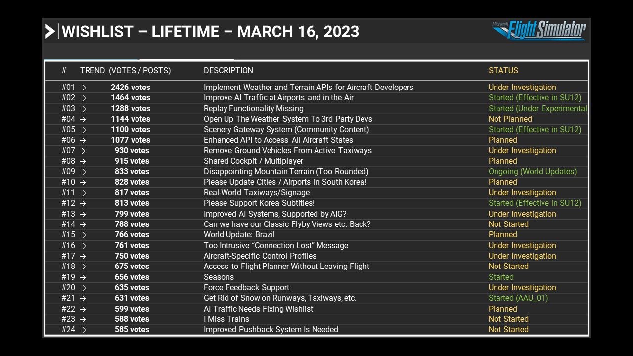
In the meantime, I’ll point to the most recent feedback snapshot from today, which shows planned updates for South Korea (#10) and Brazil (#15):
A map of the world with the quality and age of the imagery would be nice. I don’t think they will provide one though as it would show how outdated and poor most of the imagery still is. The only parts of the world that are mostly decent are the developed countries and even those have gaps. The textures around Amsterdam look pretty bad to me for example. So low res and very little contrast. Probably very old satellite imagery. Generally, to me, satellite and aerial imagery are like day and night. I’ve found myself checking the quality of the imagery at every airport I’m considering buying scenery for. Also when I go gliding I first check that the place has aerials because otherwise everything just looks so dull. Especially because you’re a lot closer to the ground in a glider.