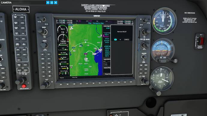
Who said I didn’t use approach plates, I was asking about the cumulative distance function that is missing and exists IRL. But they already said it will come later.
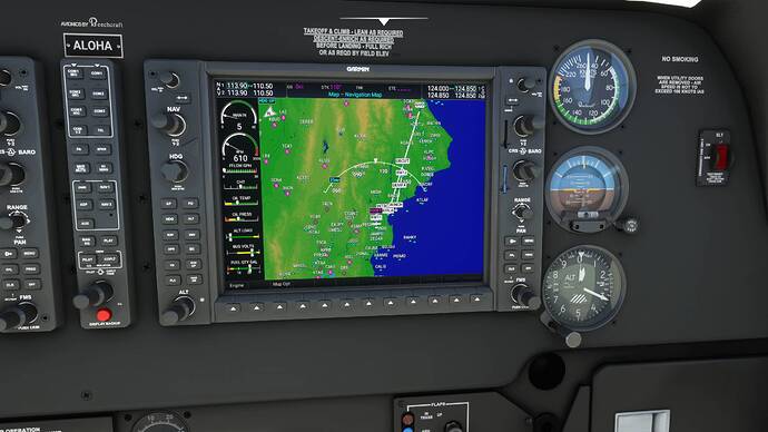
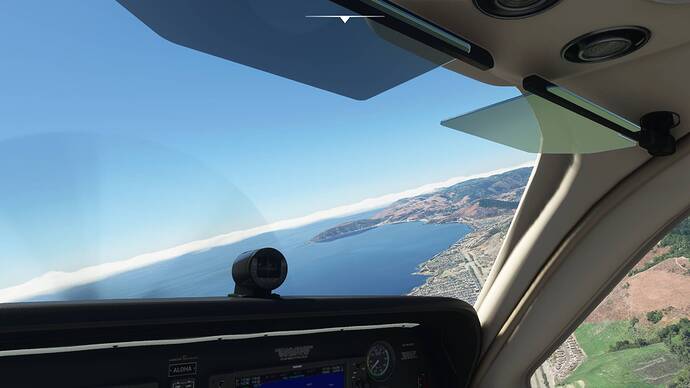
I flew the approach beginning at FRAMS in the C182T and it picked everything up as it should, and would have flown right down to the threshold. Only thing I noticed was changing to “red over red” right above Laguna Lake, but I let if fly right down to minimum altitude.
I just wanted to see if it was reliable, and other than being slightly below the glide path it brought me in for a nice landing.
I’m really liking the NXi, and getting the hang of using it. Lots of “re-learning” and putting trust and faith in the system. Helps that I’ve been flying CAVOK and daylight 80% of the time. The practice will come in handy this winter when the weather isn’t as friendly. ![]()
Is that Cessna an add-on? I have all of the MSFS planes, and I don’t remember seeing that one among them.
It is a Carenado model. I picked it up when they all went on sale for 50% off. Otherwise, the price is a bit steep IMHO.
Wish the KA would be equipped with the G1000NXi.
Asobo’s current G3X touch is rubbish and a disgrace to the King Air-
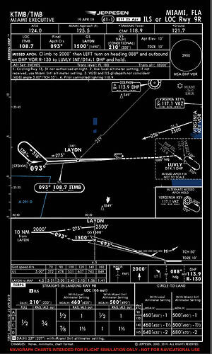
Sorry for my ignorance, but I have a question. I created a flight plan in the Bonanza for KAPF to KTMB. I added a procedure for runway 9R. For some reason the AP sent me in a holding pattern at CFDXW. Why doesn’t the AP take me right to the IAF (LAYDN), and then down to the RW. I had to manually select the runway to get the AP to work and get out of the holding pattern. What did I miss when I added the approach and does it automatically set up a holding pattern? There were brackets between the last 2 waypoints. I don’t know what the brackets represent either.
KTMB ILS RWY 09R is a Procedures Turn (PT) type approach. (see chart below).
If you intent to fly direct without the PT e.g. when approaching from the west, then a flight plan manual update would be needed to fly direct e.g. to the IAF LAYDN.
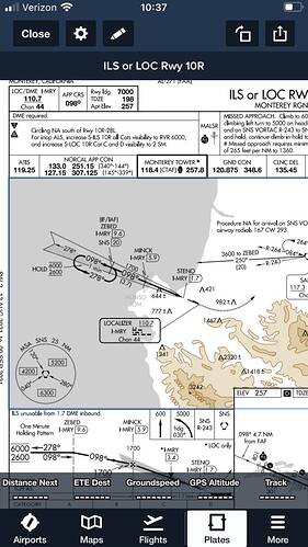
I don’t pretend to understand why these hold patterns are inserted by the NXi, beyond what the previous poster said. And that said, I don’t understand why they are necessary if you have clearance to land. I practice NXi landings, ILS and RNAV, flying between KWVI and KMRY because it’s a quick flight. Initially there is always a hold in the PROC menu before the final approach, which begins at ZEBED. To get rid of it, before takeoff, I hit PROC again to reselect the approach, RWY 10R ILS. After I do that, I get a choice — VECTORS, ZEBED, and MINCK — in that order. ZEBED and MINCK are the initial and final approach fixes respectively, so of course you wouldn’t choose between them, but why select VECTORS? Was that some kind of off-course VOR? One time, I selected it to see what would happen — and the hold vanished.
The NXi inserts the holding pattern at ZEBED because it is a part of the published approach procedure as shown in the chart below. If you are flying the approach without ATC guidance, it is required to first enter the holding pattern while descending to 2600 feet, then commence the approach.
With ATC guidance, you would be vectored to intercept the localizer in which case the hold is not required.
Ordinarily NORCAL approach would provide radar vectors, but if for some reason the ATC service is unavailable, you would be required to fly the entire procedure “as published”.
Aha! So that’s why HOLD disappears when you select vectors instead of ZEBED. Makes sense, but some other stuff I encountered today made no sense at all. (See my subsequent post.)
Today I (1) flew the Beech G36 from Santa Maria, Calif. (KSMX) to San Luis Obispo County Rgnl. (KSBP) for an ILS landing on RWY 11 at KSBP without a hitch; and (2) flew back to KSMX for an RNAV approach to RWY 12 and encountered many hitches – truly glitches – in setting up the flight plan, thanks to the G1000 NXi’s inexplicable logic.
First the ILS RWY 11 approach at KSBP. Before taking off, I followed all the steps previously outlined here: switch the CDI from GPS to LOC and set the LOC to the destination runway heading; set the heading bug to the same; check the FPL menu (no problems); go to the PROC menu and select the ILS RWY 11 approach (again no problems with intersections), and load it; and set NAV1 to the LOC frequency. After also setting the AP for my cruise altitude (4,000 for the CREPE intersection; didn’t need to go any higher along this route), I took off. Just prior to CREPE, I began descending to 2,300 ft., 100 ft. below the 2,400-foot altitude prescribed at the final approach fix to be sure of catching the glideslope. The NXi and the AP did catch it, much to my satisfaction.
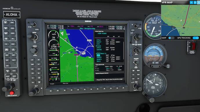
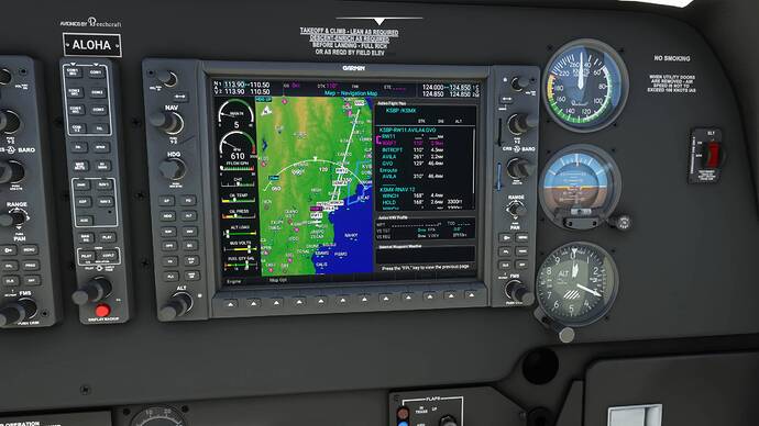
Trying to return from KSBP for an RNAV/LPV approach and landing on RNAV RWY 12 at KSMX was a different story. First the FPL glitches. The following screenshots are worth thousands of words. I had already taken off from KSBP when I took a wider look at the MFD map and saw this:
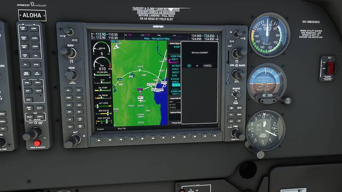
What the … .? Obviously, this was not the way to Santa Maria. I had to fix this. I started deleting extraneous and literally misleading waypoints, one after the other. SAKWE was the first one to go.
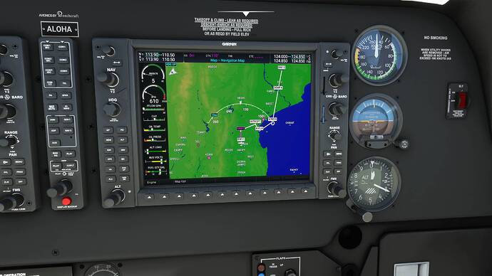
That left me with this:
I was either going to end up in Santa Maria or the Gaviota vicinity, or both. Back to the FLP menu…
Got rid of GVO
Now I had a reasonably sane FPL for KSMX…
So I took off…
And I soon found myself orbiting offshore of Avila Beach. Because of this HOLD I’d missed …
I went with it for awhile, think it was there so I could gain altitude, but when it looked like I was going to be stuck there, I bailed and started over again. After repeating all the previous steps, I got rid of this last glitch …
And I was finally on my way to KSMX, where, because I didn’t shed enough altitude soon enough, I was too high to catch the VNAV glidepath. I hand flew the G36 to the runway and restarted the flight, determined to get this VNAV-final-approach stuff right, which I did manage, once out of several tries.
My takeaways from today’s adventures and misadventures in sim flying: (1) You have got to check the “small print” in the G1000 NXi’s flight planning before you take off, lest the Garmin throw you a curveball – or two, or three; and (2) like ILS glideslopes, VPATHs are very sensitive. If you’re too high at the VNAV equivalent of an ILS final approach fix (the one with the Maltese cross on the approach plate), you won’t catch the VPATH. Oh, and one other thing: After you reach the correct final-fix flight level, be sure to change the AP altitude setting to the approach minimum to give the autopilot “permission” to follow the glidepath once it captures it.
I expect a lot of people here know all this stuff already. I just wanted to share what I’ve learned.
Good day.
Interesting stuff. So if I choose vectors (supposedly from ATC) then I won’t need the holding pattern or weird procedures…I’ll try it. I’m certainly no expert at IFR stuff, just learning.
I also fly into KMRY a lot. I like the approach and the whole area.
When landing, should the ALT hold turn off when the APR button is pressed? Having trouble getting ALT hold to cancel to descend on the GS.
I like the area lot too. We live there.
When ILS has worked for me, I haven’t had to do anything with the ALT button. I’ve hit APR at the final approach fix, and when the AP captures the glideslope, it ignores the “ALT hold” — by which I think you mean the last altitude you set to reach the glideslope — and follows ithe GS down to the runway.
in fact, for the APP button to work, you need to be on the ideal GP ramp, after that the ALT will disarm.
I had thought that choosing vectors meant ATC would give me directions. But that’s not what happens. Instead it removes those initial approach fix holds, perhaps because, in this case, the approach fixes are vectors.
VECTORS means that the approach vectors will be informed by the ATC, but pay attention to the ideal descent gradient according to the aircraft category to see what your VS will be and not get too high or too low in the IF and GP
I try to hit the GP ramp on the nose in a VNAV approach, but it doesn’t always work for me. For example, a while back I had great success with a VNAV/LPV approach to RWY 15 (I think it was) at KDCA (Washington National), and more recently flying from San Luis Obispo to Santa Maria, Calif. But I had a deuce of a time trying to get it to work at KMRY (Monterey). I was at 1,700 ft., the assigned altitude to capture the VNAV glide path at the final approach fix, MINCK, when I hit APR, and nothing happened. (VNAV was armed.) Now that I think about the approach sequence again, maybe I was too late pressing APR and had already missed the “ramp” at the initial approach fix, ZEBED. Gotta go back to KMRY to see.
I’m learning to pay a lot of attention airspeed as well as VS.
