Another day, another plane, another issue.
I attempt an IFR flight in the DA62 (max ceiling 20,000’) between Duluth and Minneapolis, MN. The world map creates a reasonable 5,000’ cruising route. A couple minutes after take-off the ATC tells me to go to 24,000 and then continues to nag me about it. I can’t tell them no. They won’t accept a lower level. It is common to have some variances between the MSFS-generated flight plan and ATC but this is absurd. What’s happening here?
Yes, I know there are good planning and ATC third party capabilities. I really want to use the MSFS-provided capabilities for now if I can.
Upload the Plan here and see if others can repro.
I don’t know how to capture and upload the plan. I simply enter the parameters into the world map planner and let it do it’s magic. In this case, I’ve tried the flight three times with similar results. Here are the details:
-
call up the world map
-
select the DA62
-
locate and select KDLH (Duluth) as departure
-
select IFR low altitude
-
locate and select KMSP (minneapolis) as arrival
-
grab KMSP ILS 12L
-
enter and it generates the same route with similar max altitudes between 4,000 and 7,000
and hit fly
-
spawned on the runway I enter altitude (as announced to the tower), set rate at 600-700’/mim, hit NAV
-
take off
-
airborn - retract gear and flaps
-
hit AP and follow ATC instructions
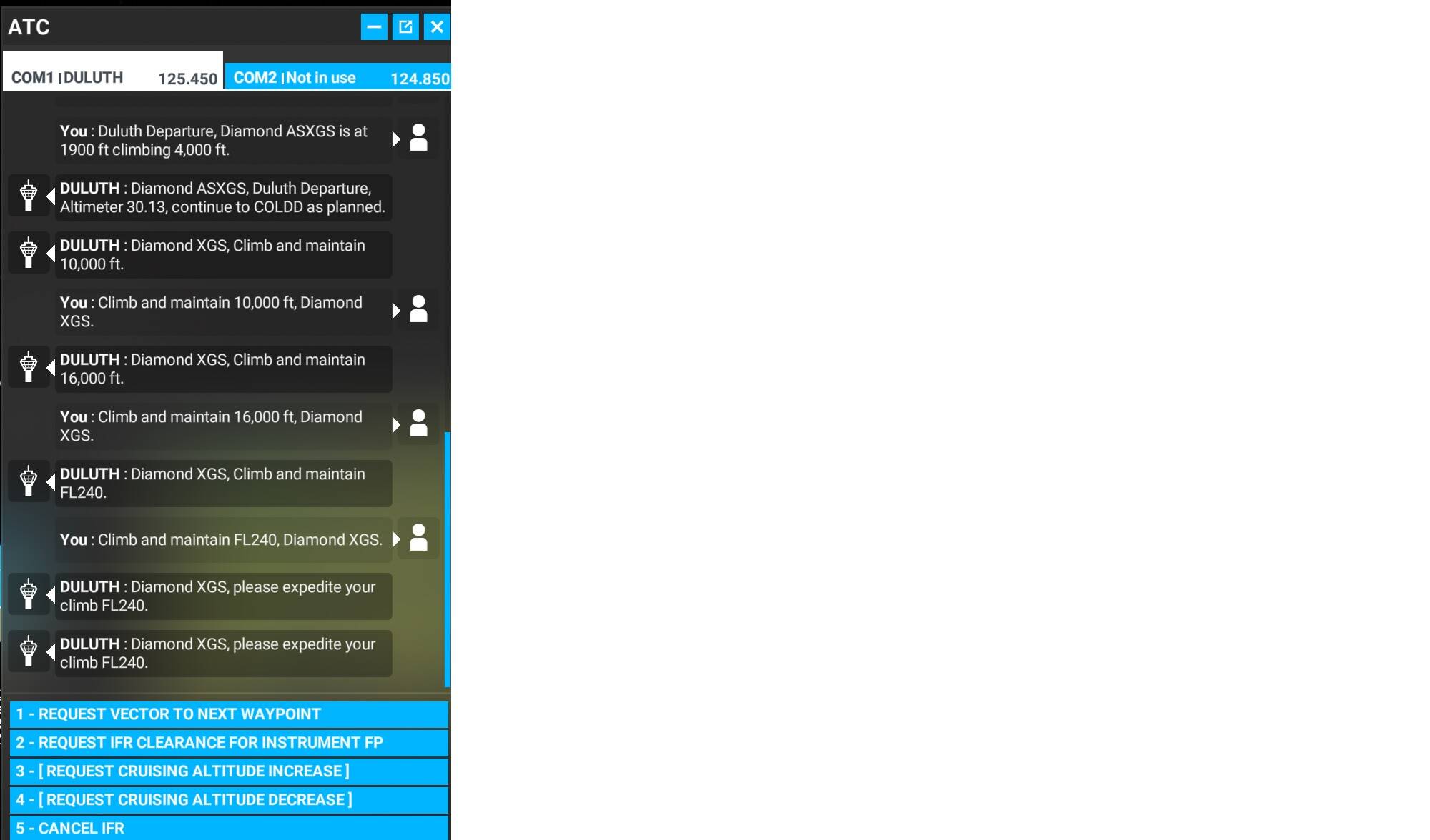
This try (the 4th) within a couple minutes the ATC rattled off “climb to 10,000”, “climb to 16,000” and “climb to FL24” all within a minute. Withing a few minutes the “please expedite your climb” starts from the ATC.
Thanks.
This is what I get when I generate that plan - note the selected flight plan and two alternates (grayed) that you can click on if you don’t like the active one.
A couple of things that you may not have done.
When selecting Duluth as the Departure, I zoom in and pick a ramp spot because I always start Cold & Dark to simulate end-to-end IFR including listening to ATIS and getting clearance.
Then I pick destination. I don’t pick an approach (ILS17 in your case) because it may be completely wrong from a winds aloft reading - I fly with Live Weather. I wait until I get closer and handed off to Approach, who will then assign me an Approach and Runway.
In order to save this as a plan - assuming you picked one of the three paths you like, you can hit the Space Bar on the keyboard, OR you can see it on the bottom of the screen and click it if you prefer.

You’ll then get a different set of options at the bottom of the World Map. Press Space Key on the keyboard OR Click on Load/Save:

Then you’ll get this Dialogue Box:
Click on Save to this PC, and you’ll get this dialogue box:
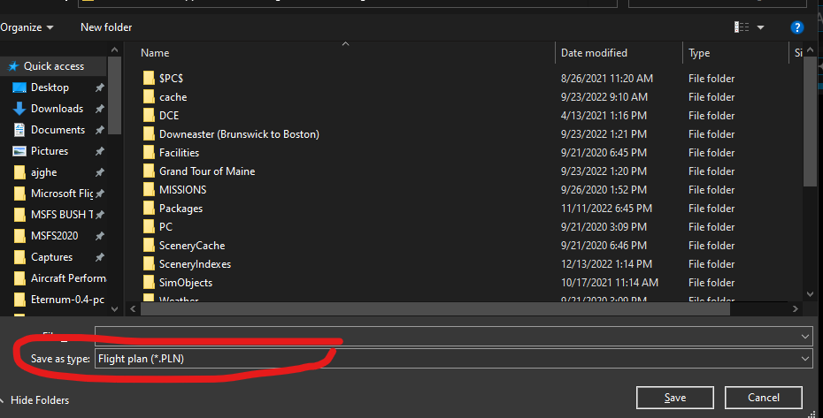
Make note of the path the flight plan is being saved to, give it a name and be sure to change the file type from Flight (.FLT) to Plan (.PLN) and hit Save.
You can then reply here in this thread and use the Upload button to launch a dialog box, locate the .PLN file and attach it to the reply, just like I did below.
TEST-DA62.PLN (6.9 KB)
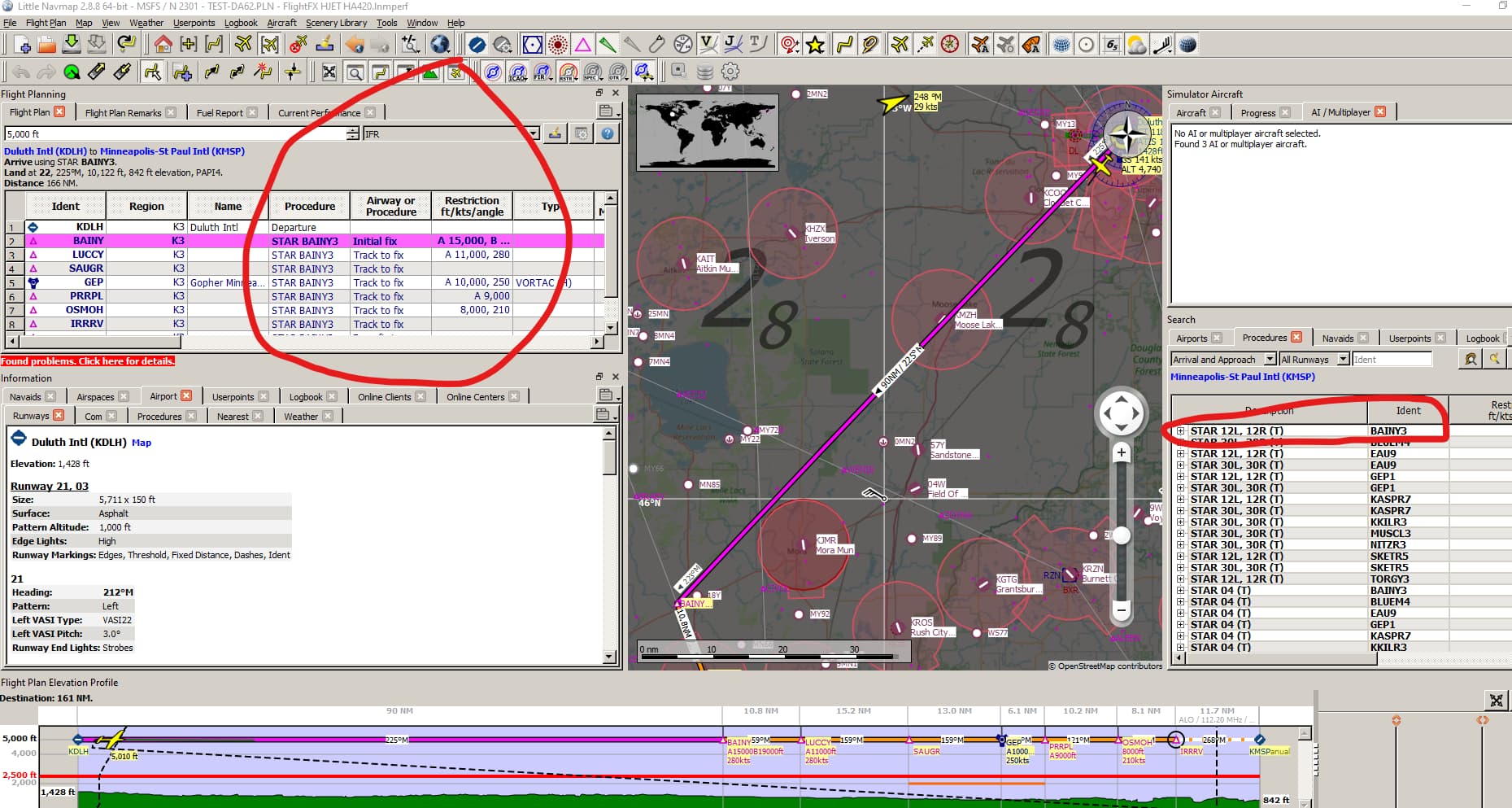
I then took the Test-DA62 flight plan and checked it out in an off-board utility Little Nav Map.
I figured out part of the problem -the Arrival at Minnesota - BAINY3, requires the airplane to be at least at 11,000 feet, so you may want to clear out any Arrival Information in the World Map. Then I think the flight plan and ATC will respect the low altitude cruise you set.
I looked up the selected approach on the FAA charts. I saw that 10000’ requirement for the selected STAR, but I didn’t comment here, because I didn’t see how that would/should translate to ATC assigning FL240.
What are your thoughts on that?
That may be due to Airspace requirements atop the routing or the expectation that the arrival connects to a Victor Jetway that has minimum altitude floors.
The real test is to remove the STAR and ensure the plan has no STARS / SIDs . The latter is unlikely as Duluth has no Departures from what I can see. I’ve shut down for the evening - others can try and remove those legs and see what happens.
1 Like
Thanks for the tests and advice. I’ll try some of your suggestions tomorrow. A lot of new implementation steps here for me to experiment and learn.
The 11,000 is interesting. If the MSFS ATC has that data, I would think the MSFS world map flight planner should too.
The 24,000 is even more strange since the plane only handles 20,000.
You definitely have to be careful with SIDs and STARs. Many of them are designed for high altitude airliner traffic routing and aren’t going to be applicable to GA aircraft. You can end up with ATC assigning unrealistic flight levels, as a result. I, too, find it pretty weird that ATC overlooks an aircraft type’s operational ceiling.
If you haven’t been doing so, I’d encourage you to check out a site like skyvector.com to review the various charts for the airports you fly out of and into. Just click the airport icon in the top left and type in the ICAO (eg KSBP, KSMX, etc.). From there you can learn about all the possible SIDs, STARs and Approach procedures. These charts are all in .pdf format. I fly with an iPad next to me for reviewing charts as I fly.
It can be daunting at first, but learning these sorts of real-world aspects of aviation will just bring so much more depth to your sim experience and feed your brain, at the same time.
This is super helpful. It’s the FAA’s guide to reading charts:
1 Like