Are the direct VFR flight plans similar to what would be done in real life?
It looks to me like it typically goes direct 3NM from airport center and then drops you 3NM off from center over the selected approach runway. The turn to intercept the runway happens on the descent leg.
It doesn’t seem optimal to enter a typical pattern.
I suspect real world VFR is to disengage AP navigation some miles out and following ATC or patterns.
How is altitude determined?
Can the Auto Pilot use this flight plan for vertical navigation? Probably not with a GNS530 I would guess.
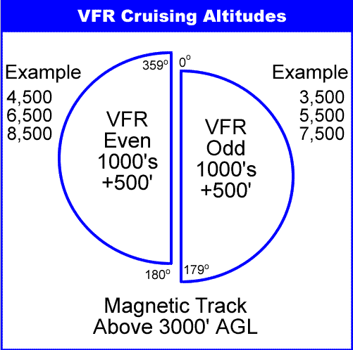
You choose your altitude, but the general rule is you should have visual contact with the ground below you.
There are conditions that allow you to fly VFR above clouds, but I believe that varies from area to area, and there are special regulations you need to follow when you do so.
A “hole” in the clouds is obviously needed to climb/descend.
VFR just means ATC isn’t controlling your flight.
You are on your own, using the “see and be seen” principle.
How you want to fly, manually or autopilot, is entirely your choice.
You have to manually enter the vertical aspects of your flight in the AP, and choose the AP mode you want to use to climb/descend.
You then use simple formula to determine when to descend:
Current altitude - pattern altitude* X 3/1000 = distance to begin descent
*usually 1000ft
GPS units can also spit out a flight plan showing the TOC and TOD. As for pattern it depends heavily on where you are headed. You dont want to blunder in on a long final when someones just turned base - with another 3 planes following on the downwind. So in that example yes you would enter the pattern carefully on the 45 deg while giving short accurate position reports. See and be seen is the name of the game out there.
So the world map doesn’t pass the altitude info to the navigation system? I haven’t checked to see if it’s available anywhere when in the sim. It was only recently I found the detailed flight plan in the world map.
I was aslo curious if the world map accounted for ground elevation. I’m on a multi leg trip and starting to see mountains in the distance.
That’s correct, the altitude is only passed on to ATC.
It isn’t in your GPS or FMC etc., except for fuel planning, and in some cases T of C and T of D plotting.
If I load the flight plan in Sky4Sim I get a ground elevation plot but I’m not quite sure if this is provided anywhere in the sim. Most flying I’ve done so far has been over low and flat terrain.
I often must adjust my altitude on a vfr flight plan, because the plan would assign me, say 3500ft, yet the gps path has me fly straight into 7,000ft mountains. Yikes!
The VFR flight plan IRL is totally different from the MSFS VFR flight plan. IRL if the flight plan is not closed within a certain amount of time, people start searching for the missing pilot and aircraft. And IRL the VFR flight plan is optional.
The pilot determines which VFR altitude to use. Sectional charts have minimum safe altitudes which are a good guide.
The MSFS VFR “flight planner” is a hack of the IFR flight planner to provide easy programming of an aircraft’s GPS/FMS. It creates a magenta line just like the IFR flight plan. IFR flights mostly use defined airways and waypoints to fly to their destination as quickly as possible. VFR flights use visual landmarks like lakes, rivers, and cities for navigation and can wander around changing course as needed to avoid clouds. One helpful tool in the MSFS VFR flight planner are the POI and fauna landmarks. It is easy to create a VFR “tour” by adding POI and fauna markers to the flight plan.
The main difference is that IFR flights have to follow ATC instructions. VFR flights don’t have to communicate with ATC and can fly to any place within VFR authorized airspace. IRL IFR aircraft are required to have specific navigation equipment and the pilot has to have the IFR charts for the flight. VFR aircraft are not required to have navigation equipment or even an electrical system. And no charts are required.
At the moment I’m trying to plot my way around the Blueridge mountains. It’s a bit trickier than I expected.
For one, the traditional pattern often isn’t possible within the capabilities of most aircraft and I can’t even find published info on the procedures. Even LittleNavMap would run me into the ground.